
Welcome New Members! We want to hear from you. Register, stop lurking and start posting!
Hot and thundery - Tropical moisture feed - Jan 4 to 14 2015
Re: Warm/hot and thundery: Jan 4 to 10
From what I can tell has 40 to 70mm from Thursday to Saturday for Melbourne
- Dane
- Supercell
- Reactions:
- Posts: 1662
- Joined: Thu Nov 26, 2009 9:51 am
- Location: Sebastopol 420m ASL
- Contact:
Re: Warm/hot and thundery: Jan 4 to 10
BOM going for between 20 and 90mm's for my area from Thursday thru to Sunday.
- MasterOfRoc
- Cumulus
- Reactions:
- Posts: 58
- Joined: Fri Sep 03, 2010 4:47 pm
- Location: St Arnaud, VIC
Re: Warm/hot and thundery: Jan 4 to 10
In St Arnaud, and I am sick of carting water, so I'll take whatever we can get
- wolfcat
- Cumulonumbus Calvas
- Reactions:
- Posts: 562
- Joined: Sun Mar 07, 2010 12:14 pm
- Location: Bentleigh East
- Contact:
Re: Warm/hot and thundery: Jan 4 to 10
I was all set up to take a great time-lapse of the thundery change coming into Melbourne on Saturday...
So here is the thundery change stormy time-lapse, which is just missing the thunder, rain and storms. ( 2 hours of recording down to just under 2 min )
[youtube]ZgJFFZN9wu8[/youtube]
So here is the thundery change stormy time-lapse, which is just missing the thunder, rain and storms. ( 2 hours of recording down to just under 2 min )
[youtube]ZgJFFZN9wu8[/youtube]
other places you will find me...
My blog...http://www.wolfcat.com.au/randomrants/
Flickr .. http://www.flickr.com/photos/wolfcat_aus/
Twitter... http://twitter.com/wolfcat
Redbubble... http://www.redbubble.com/people/wolfcat
My blog...http://www.wolfcat.com.au/randomrants/
Flickr .. http://www.flickr.com/photos/wolfcat_aus/
Twitter... http://twitter.com/wolfcat
Redbubble... http://www.redbubble.com/people/wolfcat
-
Rivergirl

- Memorial
- Reactions:
- Posts: 3674
- Joined: Sun Nov 22, 2009 6:04 pm
- Location: Ferny Creek VIC
- Contact:
Re: Warm/hot and thundery: Jan 4 to 10
Still looks good wolfcat 
- I_Love_Storms
- Supercell
- Reactions:
- Posts: 2812
- Joined: Wed Dec 02, 2009 2:01 pm
- Location: Hawthorn
Re: Warm/hot and thundery: Jan 4 to 10
Latest GFS (it is coming back):

- SC.
- Cumulonimbus
- Reactions:
- Posts: 346
- Joined: Wed Nov 25, 2009 5:57 pm
- Location: Wheelers Hill
- Contact:
Re: Warm/hot and thundery: Jan 4 to 10
I second that!Rivergirl » Tue Jan 06, 2015 9:36 am wrote:Rivergirl wrote:Still looks good wolfcat
- I_Love_Storms
- Supercell
- Reactions:
- Posts: 2812
- Joined: Wed Dec 02, 2009 2:01 pm
- Location: Hawthorn
Re: Warm/hot and thundery: Jan 4 to 10
Latest EC showing widespread big falls ie 100-150mm in wide parts of state higher in alpine areas in North east
-
Australis(Shell3155)

- Supercell
- Reactions:
- Posts: 3147
- Joined: Mon Nov 30, 2009 8:05 pm
- Location: FTG
- Contact:
Re: Warm/hot and thundery: Jan 4 to 10
Might be a good time to get gutter cleaned out... clear the leaves off the tank strainers...
tad excited...
tad excited...
- I_Love_Storms
- Supercell
- Reactions:
- Posts: 2812
- Joined: Wed Dec 02, 2009 2:01 pm
- Location: Hawthorn
Re: Warm/hot and thundery: Jan 4 to 10
Cleaned mine out last night!! Not risking it if we get 50mm or so in one hit
-
Australis(Shell3155)
- Supercell
- Reactions:
- Posts: 3147
- Joined: Mon Nov 30, 2009 8:05 pm
- Location: FTG
- Contact:
Re: Warm/hot and thundery: Jan 4 to 10
best get that plumber sorted (gutters of course his job)..
I see some small branches in one of those odd roof angles.. those tricky ones where the water cant get away...
or where hail builds up so I've found out in the past..
is there going to be wind with this..?
I see some small branches in one of those odd roof angles.. those tricky ones where the water cant get away...
or where hail builds up so I've found out in the past..
is there going to be wind with this..?
- dazrain
- Cumulonimbus
- Reactions:
- Posts: 111
- Joined: Thu Feb 03, 2011 7:39 pm
- Location: Brighton East, Victoria
Re: Warm/hot and thundery: Jan 4 to 10
It's a humid cesspit outside already.
Two more days of buildup together with heat can only conclude with one thing - a massive storm!
Two more days of buildup together with heat can only conclude with one thing - a massive storm!
-
Didjman

- Supercell
- Reactions:
- Posts: 2100
- Joined: Fri Sep 03, 2010 2:52 pm
- Location: Wallan, Vic 328m ASL
- Contact:
Re: Warm/hot and thundery: Jan 4 to 10
19C here atm. 78%RH. insane but loving it 
Peter
Peter
- I_Love_Storms
- Supercell
- Reactions:
- Posts: 2812
- Joined: Wed Dec 02, 2009 2:01 pm
- Location: Hawthorn
Re: Warm/hot and thundery: Jan 4 to 10
Yes Sunday looks a bit windy potentially maybe some of the other days
- StratoBendigo
- Supercell
- Reactions:
- Posts: 2833
- Joined: Fri Jan 02, 2015 2:18 pm
- Location: Kangaroo Flat
Re: Warm/hot and thundery: Jan 4 to 10
06Z GFS looks ominous. Especially for Friday - Sunday period. Aligns mostly with EC which is telling.
- Jake Smethurst
- Supercell
- Reactions:
- Posts: 3583
- Joined: Mon Nov 23, 2009 8:49 pm
- Location: Cheltenham
Re: Warm/hot and thundery: Jan 4 to 10
Very sticky today, was sweating like I was in Bali, and I am fit! Can't imagine what tomorrow or Thursday will feel like in this humidity. Otherwise it was relatively fine and warm here in Brighton today, managed to reach 28.5 degrees.
Haven't really had the time to post until now, but have been keeping an eye on the models. Jeepers at what they are predicting for some areas across the country, even for us here in Victoria, falls potentially in excess of 100mm. It's still very variable, although I would probably be inclined to lock in large falls for somewhere in Victoria. The majority of the models continue to suggest large falls across the state, except for ACCESS, which isn't and hasn't really been interested, in the second half of the event anyway. It was touch and go with the EC model also - up until tonight it was keeping most of the rain away from Victoria until Monday, but in tonight's run has pushed everything more east across Victoria, now a little similar to GFS but not completely. If I was to hazard a guess now as to rainfall amounts over Melbourne, I would say 50-100mm, but if we can get that low a little closer then we'd be in for some much much higher totals. Still a waiting game though, models still have to firm on the details. Tropical incursions are always so frustratingly tricky to predict, but that's the fun of it I guess
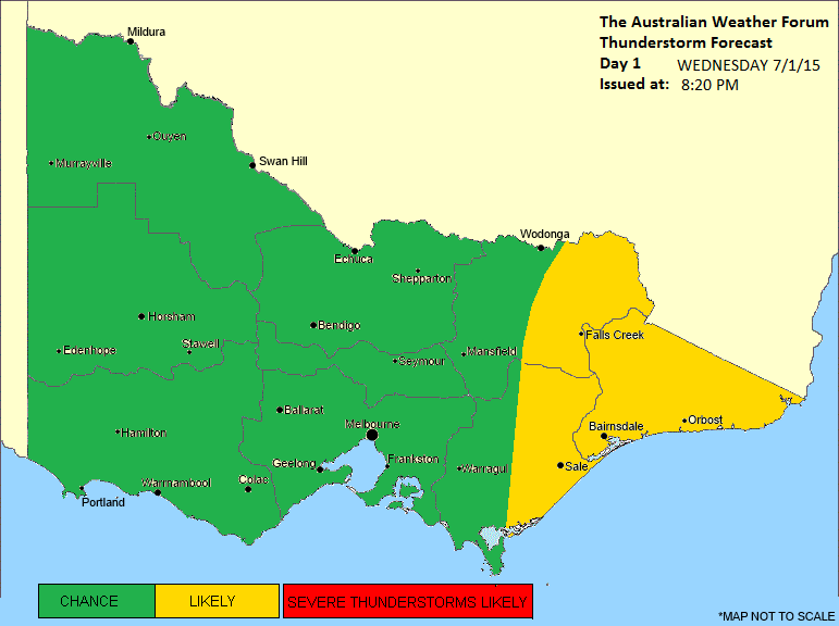
We can be pretty confident in tomorrow and Thursday though. Back to basics ... instability increasing across the state overnight along with that high moisture and quite hot surface temperatures as a trough lays over western Victoria or near there. Expect to see scattered showers and isolated thunderstorms develop across most areas, mainly during the afternoon with convective heating, but I'd be inclined to suggest thunderstorms are more likely over the eastern districts near the ranges where there is deeper lifting and also near Gippsland where if a seabreeze convergence can get going, a focus will be there. But obviously, not ruling it out for Melbourne, there is indeed a good risk. The showers and storms will be pulsey, and with the high moisture expect heavy falls which may lead to flash flooding under them. Large hail and damaging wind also possible. We did our thunderstorm charts earlier this evening for tomorrow, here it is:
Thunderstorm Forecast - Day 1
Issued at 8:20pm Tuesday 6th January 2015
Discussion for Wednesday
Instability increases across Victoria during Wednesday, with isolated thunderstorms becoming a possibility across the entire state. They are most likely over the eastern ranges, although as marked, could develop anywhere. High levels of moisture and slower moving storms also means that heavy rainfall leading to flash flooding is the biggest threat in storm activity, although large hail and damaging winds are also possible. Activity is more likely during the afternoon.
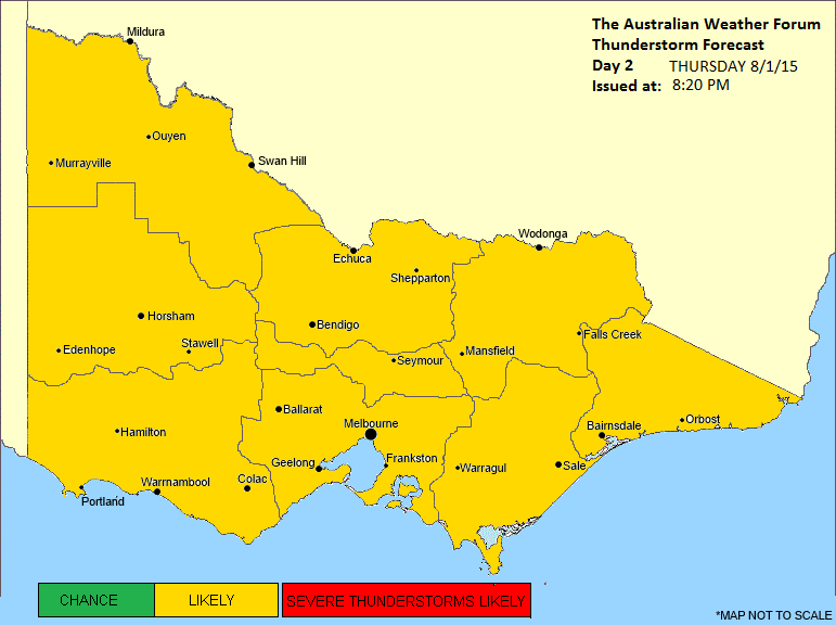
For Thursday we are likely to see even higher moisture levels across the state and even more unstable uppers as the trough over western Victoria slowly moves eastwards. On current guidance I'd say it will reach Melbourne around 5pmish. Likely to see showers and thunderstorms develop across all areas of the state, particularly near the trough, so central parts including Melbourne could be in with a fantastic opportunity of thunderstorms! These storms will be more organised so likely to see damaging winds, large hail and flash flooding. Again we created the day 2 chart earlier this evening for our website:
Thunderstorm Forecast - Day 2
Issued at 8:20pm Tuesday 6th January 2015
Discussion for Thursday
Moisture levels are expected to be very high across Victoria during Thursday, with warm to hot surface temperatures and high instability through all areas. This is ahead of a trough of low pressure which will begin moving eastwards across the state during the day, reaching Melbourne at roughly 5pm. Due to the combination of these variables, scattered thunderstorm activity is likely across all areas of the state, but particularly near the trough of low pressure. Flash flooding is again the highest threat regarding severe phenomena, though organized cells are possible meaning damaging winds and large hail are also possible.
Beyond Thursday is when models get a little tricky to diagnose/examine. Broadly speaking we are likely to see areas of rain potentially across the state from Friday until early Monday morning if GFS is to be believed. Highest falls will be wherever the low develops closest to, but despite that, fairly high totals expected nonetheless. Southwest of the state could be hit and miss, but watch for a wrap-around in the low moves into Bass Strait.
We've also updated our forecast for Melbourne (http://theaustralianweatherforum.com/me ... ecast.html) and Victoria State (http://theaustralianweatherforum.com/vi ... ecast.html) on our website. Lots of work goes into these by the team!
Haven't really had the time to post until now, but have been keeping an eye on the models. Jeepers at what they are predicting for some areas across the country, even for us here in Victoria, falls potentially in excess of 100mm. It's still very variable, although I would probably be inclined to lock in large falls for somewhere in Victoria. The majority of the models continue to suggest large falls across the state, except for ACCESS, which isn't and hasn't really been interested, in the second half of the event anyway. It was touch and go with the EC model also - up until tonight it was keeping most of the rain away from Victoria until Monday, but in tonight's run has pushed everything more east across Victoria, now a little similar to GFS but not completely. If I was to hazard a guess now as to rainfall amounts over Melbourne, I would say 50-100mm, but if we can get that low a little closer then we'd be in for some much much higher totals. Still a waiting game though, models still have to firm on the details. Tropical incursions are always so frustratingly tricky to predict, but that's the fun of it I guess
We can be pretty confident in tomorrow and Thursday though. Back to basics ... instability increasing across the state overnight along with that high moisture and quite hot surface temperatures as a trough lays over western Victoria or near there. Expect to see scattered showers and isolated thunderstorms develop across most areas, mainly during the afternoon with convective heating, but I'd be inclined to suggest thunderstorms are more likely over the eastern districts near the ranges where there is deeper lifting and also near Gippsland where if a seabreeze convergence can get going, a focus will be there. But obviously, not ruling it out for Melbourne, there is indeed a good risk. The showers and storms will be pulsey, and with the high moisture expect heavy falls which may lead to flash flooding under them. Large hail and damaging wind also possible. We did our thunderstorm charts earlier this evening for tomorrow, here it is:
Thunderstorm Forecast - Day 1
Issued at 8:20pm Tuesday 6th January 2015
Discussion for Wednesday
Instability increases across Victoria during Wednesday, with isolated thunderstorms becoming a possibility across the entire state. They are most likely over the eastern ranges, although as marked, could develop anywhere. High levels of moisture and slower moving storms also means that heavy rainfall leading to flash flooding is the biggest threat in storm activity, although large hail and damaging winds are also possible. Activity is more likely during the afternoon.
For Thursday we are likely to see even higher moisture levels across the state and even more unstable uppers as the trough over western Victoria slowly moves eastwards. On current guidance I'd say it will reach Melbourne around 5pmish. Likely to see showers and thunderstorms develop across all areas of the state, particularly near the trough, so central parts including Melbourne could be in with a fantastic opportunity of thunderstorms! These storms will be more organised so likely to see damaging winds, large hail and flash flooding. Again we created the day 2 chart earlier this evening for our website:
Thunderstorm Forecast - Day 2
Issued at 8:20pm Tuesday 6th January 2015
Discussion for Thursday
Moisture levels are expected to be very high across Victoria during Thursday, with warm to hot surface temperatures and high instability through all areas. This is ahead of a trough of low pressure which will begin moving eastwards across the state during the day, reaching Melbourne at roughly 5pm. Due to the combination of these variables, scattered thunderstorm activity is likely across all areas of the state, but particularly near the trough of low pressure. Flash flooding is again the highest threat regarding severe phenomena, though organized cells are possible meaning damaging winds and large hail are also possible.
Beyond Thursday is when models get a little tricky to diagnose/examine. Broadly speaking we are likely to see areas of rain potentially across the state from Friday until early Monday morning if GFS is to be believed. Highest falls will be wherever the low develops closest to, but despite that, fairly high totals expected nonetheless. Southwest of the state could be hit and miss, but watch for a wrap-around in the low moves into Bass Strait.
We've also updated our forecast for Melbourne (http://theaustralianweatherforum.com/me ... ecast.html) and Victoria State (http://theaustralianweatherforum.com/vi ... ecast.html) on our website. Lots of work goes into these by the team!
Jake - Senior AWF Forecaster
Feel free to send me a private message if you have any questions.
Feel free to send me a private message if you have any questions.
-
Rivergirl
- Memorial
- Reactions:
- Posts: 3674
- Joined: Sun Nov 22, 2009 6:04 pm
- Location: Ferny Creek VIC
- Contact:
Re: Warm/hot and thundery: Jan 4 to 10
Thanks for the comprehensive update and forecasts Jake
- I_Love_Storms
- Supercell
- Reactions:
- Posts: 2812
- Joined: Wed Dec 02, 2009 2:01 pm
- Location: Hawthorn
Re: Warm/hot and thundery: Jan 4 to 10
Hmm looking good! Expecting between 50 and 150mm in Eastern Suburbs from this event. Probably about 80 to 100mm will be the actual outcome. Saturday night into Sunday will be very wet I think.
- stevco123
- Supercell
- Reactions:
- Posts: 2942
- Joined: Sat Aug 07, 2010 7:42 pm
- Location: Cranbourne 78m asl
Re: Warm/hot and thundery: Jan 4 to 10
Ominous clouds about at the moment (i forget their name) indicating there will be instability later (possibly storms) around the area.
https://www.weatherlink.com/bulletin/53 ... 76dd68e8bc: for current weather updated every 2 minutes
- wolfcat
- Cumulonumbus Calvas
- Reactions:
- Posts: 562
- Joined: Sun Mar 07, 2010 12:14 pm
- Location: Bentleigh East
- Contact:
Re: Warm/hot and thundery: Jan 4 to 10
And the BoM have officially switched off the LaTrobe St weather station as of today.
edit: My bad - it was yesterday at 9am...
edit: My bad - it was yesterday at 9am...
Last edited by wolfcat on Wed Jan 07, 2015 12:12 pm, edited 1 time in total.
other places you will find me...
My blog...http://www.wolfcat.com.au/randomrants/
Flickr .. http://www.flickr.com/photos/wolfcat_aus/
Twitter... http://twitter.com/wolfcat
Redbubble... http://www.redbubble.com/people/wolfcat
My blog...http://www.wolfcat.com.au/randomrants/
Flickr .. http://www.flickr.com/photos/wolfcat_aus/
Twitter... http://twitter.com/wolfcat
Redbubble... http://www.redbubble.com/people/wolfcat