Welcome New Members! We want to hear from you. Register, stop lurking and start posting!

Vic - More rain likely March 7th - 10th

Archived Weather Events since 2009.
If you have any valuable content to add to any locked thread, please PM board moderator.
User avatar
Karl Lijnders
Tornadic Supercell
Reactions:
Posts: 5771
Joined: Sun Nov 22, 2009 11:17 pm
Location: Knoxfield, Victoria

Re: Vic - More rain likely March 7th - 10th

Post by Karl Lijnders »

IDV65758
Australian Government Bureau of Meteorology
Victoria Regional Office

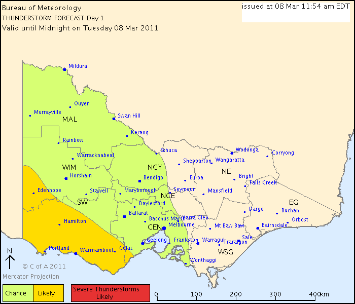
THUNDERSTORM FORECAST
Issued at 11:54 am Tuesday, 8 March 2011,
Valid until midnight on Tuesday, 8 March 2011.
Middle level instability combined with favourable upper level flow provide the chance of isolated thunderstorm activity across the northern part of the region shown. As thunderstorm activity may be slow moving in this region, there is a slight chance of flash flooding. Across the southern part, a surface trough will provide enhanced upmotion that makes the chance of thunderstorms in this region more likely. There is a chance that the direction of motion may line up with the orientation of the trough from later this afternoon, enhanced showers or thunderstorms may move over the same region providing a chance of flash flooding over this region.

Image
Former Owner - The Australian Weather Forum. Email me anytime - weatherman1000@hotmail.com
User avatar
Karl Lijnders
Tornadic Supercell
Reactions:
Posts: 5771
Joined: Sun Nov 22, 2009 11:17 pm
Location: Knoxfield, Victoria

Re: Vic - More rain likely March 7th - 10th

Post by Karl Lijnders »

Seeing plenty of sunshine ahead of the rain developing over the west so we could see thunderstorms develop in the middle levels of the atmosphere this evening and become embedded in the developing areas of rain. Anticipating Melbourne to see rain after dark.

A good chance statewide of seeing 10-20mm over the course of the week with locally heavy falls of 50mm scattered in W and C areas where the heavier rain trains over.

Now there is the added insurance of a convective weekend so totals could well be supplemented by the time we get to Sunday.

A very slim chance of seeing this whole sequence becoming protracted and a deepening low form in the easterly winds over the weekend. That is to watch as it will spark large scale rainfall.
Former Owner - The Australian Weather Forum. Email me anytime - weatherman1000@hotmail.com
M
MurrayRiver1712
Cumulus
Reactions:
Posts: 61
Joined: Sat Feb 05, 2011 10:18 am
Location: Echuca

Re: Vic - More rain likely March 7th - 10th

Post by MurrayRiver1712 »

About 12pm in Echuca it looked and felt like a storm was brewing up, and was very windy. Now the wind has died down to nothing and its overcast. Weird day indeed.
User avatar
Petros
Supercell
Reactions:
Posts: 2001
Joined: Tue Dec 01, 2009 6:25 pm
Location: Maffra, Gippsland, Vic

Re: Vic - More rain likely March 7th - 10th

Post by Petros »

Karl Lijnders » Tue Mar 08, 2011 4:54 pm wrote:
Karl Lijnders wrote: ........A very slim chance of seeing this whole sequence becoming protracted and a deepening low form in the easterly winds over the weekend. That is to watch as it will spark large scale rainfall.
Muggy 32.5C here today, calm overcast and a perfect evening to fire up the BBQ (which I will do soon). :D

Is AccessR any good? The old MLAPS was always very close after its last run pre-event, so you'd expect its replacement to be the same. For us AccR progs 30mm rain over a 24hr period starting 11am tomorrow, yet all the others are reluctant to squeeze out any more than (a welcome) 6mm-odd. What the?

As for your quote Karl, get out of my territory! I'm the one who has the patent on calling doomed-to-fail Easterly Rain Events!!! :D :D ;)

..... and now off to have another look to see what I missed!

Love the generous edit time on AWF!

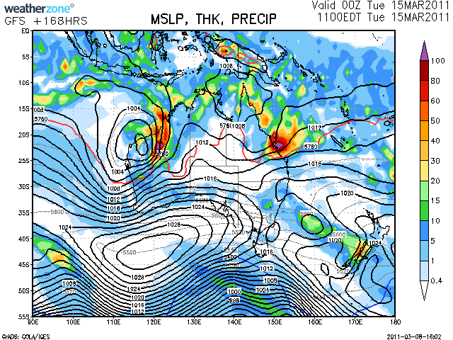
OK Karl, shopped around and this is the nearest threat to a cut-off I can find on the current runs:
Image

Other models have the next high sausaging in from the W to push any low formation out into the Tasman. So for me, its fairly unlikely as you said, yet worth watching because is a fair way out, a change is coming on Sunday, and its the season for cut-offs in SE Aus in my experience.
Last edited by Petros on Tue Mar 08, 2011 6:20 pm, edited 1 time in total.
User avatar
Karl Lijnders
Tornadic Supercell
Reactions:
Posts: 5771
Joined: Sun Nov 22, 2009 11:17 pm
Location: Knoxfield, Victoria

Re: Vic - More rain likely March 7th - 10th

Post by Karl Lijnders »

LOL!! Yes make sure you have another look as I could be so sleep deprived I am making it up :P

ACCESS 3 day is like the old MLAPS with much better accuracy according to some. It does hold an interesting pressure pattern come the weekend with a low lingering over the NE and easterly winds developing over the state. If the high can undercut and cradle this system, we could see some major changes coming to our weather forecasts, especially eastern and northern VIC.
Former Owner - The Australian Weather Forum. Email me anytime - weatherman1000@hotmail.com
User avatar
Petros
Supercell
Reactions:
Posts: 2001
Joined: Tue Dec 01, 2009 6:25 pm
Location: Maffra, Gippsland, Vic

Re: Vic - More rain likely March 7th - 10th

Post by Petros »

Amazing mild night here, crickets chirping loudly, 26C.

The satloop shows it'll be tomorrow night before the changes out in the bight merge and hit us - as I interpret what I see.
User avatar
Karl Lijnders
Tornadic Supercell
Reactions:
Posts: 5771
Joined: Sun Nov 22, 2009 11:17 pm
Location: Knoxfield, Victoria

Re: Vic - More rain likely March 7th - 10th

Post by Karl Lijnders »

Petros you will find that the lows will not be obvious in the charts!! It is what is unseen that is the wild card!!! :)
Former Owner - The Australian Weather Forum. Email me anytime - weatherman1000@hotmail.com
d
droughtbreaker
Supercell
Reactions:
Posts: 2844
Joined: Wed Nov 25, 2009 7:50 pm
Location: Mount Macedon, VIC, 520m asl

Re: Vic - More rain likely March 7th - 10th

Post by droughtbreaker »

I am a bit concerned that the ACCESS models are the only ones really going for much with this system. EC and GFS don't seem all that interested to me. Still, 5-10mm in Melbourne and 10-20mm on the ranges still seems a reasonable prospect with 25-40mm falls over parts of the west. I would like to see a bit more action on the radar at this stage of proceedings but we will see what happens overnight and tomorrow morning.
T
Twister
Cumulonumbus Calvas
Reactions:
Posts: 914
Joined: Sun Nov 29, 2009 10:47 pm
Location: Brisbane Qld

Re: Vic - More rain likely March 7th - 10th

Post by Twister »

I agree to I cant see much rain falling, the rain in SA is moving out quickly, no more developing the NE in feed moving quickly E SE, over 40mm in Broken hill, it hasnt been as wet as I thought it would interested to see if forecast comes off tomorrow should be interesting

Another great warm day and still pretty good out there now
Now Living in Wet QLD
User avatar
stratospear
Supercell
Reactions:
Posts: 1261
Joined: Sat Dec 19, 2009 9:38 am
Location: Usually Bendigo

Re: Vic - More rain likely March 7th - 10th

Post by stratospear »

Strong upper westerlies over Vic are quickly pushing moisture out East. Not sure if we'll get anything much at all now.
User avatar
Didjman
Supercell
Reactions:
Posts: 2100
Joined: Fri Sep 03, 2010 2:52 pm
Location: Wallan, Vic 328m ASL
Contact:

Re: Vic - More rain likely March 7th - 10th

Post by Didjman »

A clear dawn here. Temps 17.4/13.0 with a breath of SW breeze.
Peter
P
Petethemoskeet
Cumulonimbus
Reactions:
Posts: 272
Joined: Mon Mar 08, 2010 1:06 pm
Location: Toowoomba

Re: Vic - More rain likely March 7th - 10th

Post by Petethemoskeet »

No rain here and can't see any falling from this system.It looks to be heading NE into NSW.Then again the potential for storms on Sun/Mon look better
S
Skywalker
Supercell
Reactions:
Posts: 1874
Joined: Sun Nov 29, 2009 10:03 am
Location: Burnside Heights/Cowes (Home) & Sunshine West (Work)

Re: Vic - More rain likely March 7th - 10th

Post by Skywalker »

I must be on another planet or something. We have had about 1mm of rain this week, if that, yet all I've seen in the forecasts is "Areas of rain". :? :dunno:
Caroline Springs, Melbourne's meteorological boredom zone.
User avatar
stratospear
Supercell
Reactions:
Posts: 1261
Joined: Sat Dec 19, 2009 9:38 am
Location: Usually Bendigo

Re: Vic - More rain likely March 7th - 10th

Post by stratospear »

It looks like the first wave dumped its load on SA, not Vic as originally forecast, thus delaying everything by 24 hours. Talk about getting it wrong.

However there appears to be some lifting occurring in Western Vic (the second wave) atm, and latest EC has got all excited about it dumping about 40mm on us tonight. It certainly "smells" of rain out there this morning. BOM forecast explorer isn't at all interested in much at all, while GFS says only 20mm.
W
WaterBaby
Cumulonimbus
Reactions:
Posts: 109
Joined: Sun Jan 30, 2011 5:24 pm
Location: Loddon shire, VIC

Re: Vic - More rain likely March 7th - 10th

Post by WaterBaby »

Rained pretty lightly here for a few hours early this morning, and it's still quite misty with a few drops here and there but nothing too exciting.
User avatar
occluded
Cumulonumbus Calvas
Reactions:
Posts: 611
Joined: Tue May 04, 2010 3:26 pm
Location: Mooroolbark 130m asl

Re: Vic - More rain likely March 7th - 10th

Post by occluded »

Yes, smells like it's going to rain a bit here too (not exactly scientific I know) but that rain to the NW of Melbourne seems to have been breaking up all morning before it reaches here. Didn't check the manual gauge this morning but AWS showing a whopping 0.4mm.

A line of sparkies out to the NW but not holding out much hope that anything will make it this far. Hopefully Sunday/Monday looking better for storm activity?
M
MurrayRiver1712
Cumulus
Reactions:
Posts: 61
Joined: Sat Feb 05, 2011 10:18 am
Location: Echuca

Re: Vic - More rain likely March 7th - 10th

Post by MurrayRiver1712 »

Mainly drizzle in Echuca, just after lunch it has become a bit heavier, but i dont think there is much rain on the way today.
L
Lily
Supercell
Reactions:
Posts: 4014
Joined: Wed Nov 25, 2009 10:29 pm
Location: Rowville/Lysterfield

Re: Vic - More rain likely March 7th - 10th

Post by Lily »

Woke to rain this morning, a few showers on and off today, and another just passing through, 4mm since 12am.

Looks like a few strikes of lightning in the NW of the state?
User avatar
Karl Lijnders
Tornadic Supercell
Reactions:
Posts: 5771
Joined: Sun Nov 22, 2009 11:17 pm
Location: Knoxfield, Victoria

Re: Vic - More rain likely March 7th - 10th

Post by Karl Lijnders »

That is the beginning of the rainband which was always set to start later in C and E VIC as a secondary pulse.

Should see 20-50mm through C and E VIC.
Former Owner - The Australian Weather Forum. Email me anytime - weatherman1000@hotmail.com
User avatar
Anthony Violi
Supercell
Reactions:
Posts: 2652
Joined: Mon Nov 23, 2009 9:03 pm
Location: Lilydale
Contact:

Re: Vic - More rain likely March 7th - 10th

Post by Anthony Violi »

The main feature so far has been the main trigger is almost stationary, thus any rain over the last 24 hours has petered out into not much by the time its meandered through Central. Slowly but surely its inching closer and the rain is getting more consistent, and also the flow is shifting more NNW rather than WNW. Cant see too many totals above 15mm, but am happy to be surprised as its quite humid and slow moving.
http://www.therealworldweatherforum.com" onclick="window.open(this.href);return false;

avweatherforecasts.com
Locked