Morning updates on all models, has now made this a VERY interesting system.
Agree with hillbilly that the WAA on this system is very impressive, which should lead to great up slide and a lot of rain forming in S NSW and N NE VIC and moving across C and E Vic
Looks like the system will Peak in SA then an even bigger peak E of a line Ivanhoe, Swan hill, were the rain band may stall and even tilt just a little as the cold air is flung up over SA and later into W VIC
NE and N facing slopes looking to do really well again, could you see another 50mm Bendgio what a wet year you are having.
Falls of 100mm possible again in some parts mostly the mounts, cant believe that every major system we talk about and receive 100-150mm falls its just nuts but loving this La Nina and pattern.
Also of Note is that a lot of Rain looks to fall in SE NSW were they had 150-200mm 10 days ago with another possible 50-100mm there this weekend things could get really bad in that part of the world so watch out.
Agree that storms are not looking great Friday and Saturday more so areas of rain and the odd embedded storm looking like another Heavy rain event then almost cold air outbreak behind it with lots of Showers few storms and gusty winds nothing like Friday 2 weeks ago though.
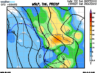
Watch the cloud explode in WA tomorrow and slowly make it way into SE Aus were it will transition into a stalling trough then cut off low feature
SO Friday look for rain and a few storms to develop in the west and over parts of NSW Friday night this rain will move slowly S SE Overnight
Saturday morning rain will have spread throughout the state, clearing the West later, but thickening and becoming more extensive through C and E areas with slight tilting expect the rain to come more from the N maybe NE than NW on Saturday as a low develops some were in the area, cooler in the W with gusty winds warm and humid in the E
Sunday rain band clears out apart from the east were rain will linger Showers for rest of the state more widespread in S and Mount regions but with upper low about could have more rain areas about not sure at this stage will be wet and cooler for most though.
Hoping for 20mm here looking good for a 15-25mm fall which is great we have all done so well this month.
Many will see another 30-50mm with many 50-80mm falls and quite a few 100+ falls expected to i feel
Only bad news out of this is for farmers and flood affected areas as both dont need rain right now
Still would like another 48 hours before totally sure on this event
Looking great though, Most models putting the low S of Gippy and nice cold pool in SW VIC by Saturday Night
HAPPY TIMES

Welcome New Members! We want to hear from you. Register, stop lurking and start posting!
Victoria: Low Pressure System Cup Weekend 2010
- Twister
- Cumulonumbus Calvas
- Reactions:
- Posts: 914
- Joined: Sun Nov 29, 2009 10:47 pm
- Location: Brisbane Qld
Re: Vic - a lick of cold air rising into moist atm 29-31/10/
Now Living in Wet QLD
Re: Victoria: Low Pressure System Cup Weekend 2010
Of course we're going to have torrential rain...I'm going camping 
Just tell me I'm not going to get a repeat of the New Years Day storm I had at lake at lake eildon.
Just tell me I'm not going to get a repeat of the New Years Day storm I had at lake at lake eildon.
- droughtbreaker
- Supercell
- Reactions:
- Posts: 2844
- Joined: Wed Nov 25, 2009 7:50 pm
- Location: Mount Macedon, VIC, 520m asl
Re: Vic - a lick of cold air rising into moist atm 29-31/10/
Yep, that's pretty much the way I see it. 30C is a near certainty for western suburbs on Friday. Melbourne city and the rest of the metro area may still be touch and go but it will certainly get close. Warm air advection and tropical moisture combined with the cold pool behind is the key to this system, it could be very big, thinking some areas of flooding in areas on and north of the divide. I wonder if Derby day will go ahead? It will be a very soggy one that's for sure.hillybilly wrote:This system is really starting to look like a doozie. The warm air advection/northerlies on Friday stretch from Vic all the way to Cape York which should see a rapid increase in moisture and strong upslide. To be honest look to me like more of a stratiform rain event with embbeded storms rather that a storm outbreak initially. Rain totals could be excessive, particularly on the northern slopes - not good given the number of people who will be camping over the "long" weekend.
Potential for a wrap-around rain band into central areas which could be slow moving on Sat/Sun. Cold pool then over Vic on Monday with very cold air (850T around -3C) - should be lots of intense convection, particularly north of the divide - have seen some of the nastiest storm outbreaks occur in these situations where a deep cold pool finds itself cut off over Victoria with only weak low level flow and a warm spring sun.
Not sure about rainfall totals - but expecting somewhere between 40 and 100mm in Ferny Creek - the big uncertainty is the extent of the wrap around for us.
Off to the beach for a week so it's gauranteed to be cold and wet next week
BTW should/could see the first 30C in Melbourne on Friday - BOG/OCF has 28C.
-
Supercellimpact

- Supercell
- Reactions:
- Posts: 1238
- Joined: Thu Oct 07, 2010 8:39 pm
- Location: Bendigo
Re: Vic - a lick of cold air rising into moist atm 29-31/10/
That means Bendigo will get hammered.droughtbreaker wrote:Yep, that's pretty much the way I see it. 30C is a near certainty for western suburbs on Friday. Melbourne city and the rest of the metro area may still be touch and go but it will certainly get close. Warm air advection and tropical moisture combined with the cold pool behind is the key to this system, it could be very big, thinking some areas of flooding in areas on and north of the divide. I wonder if Derby day will go ahead? It will be a very soggy one that's for sure.hillybilly wrote:This system is really starting to look like a doozie. The warm air advection/northerlies on Friday stretch from Vic all the way to Cape York which should see a rapid increase in moisture and strong upslide. To be honest look to me like more of a stratiform rain event with embbeded storms rather that a storm outbreak initially. Rain totals could be excessive, particularly on the northern slopes - not good given the number of people who will be camping over the "long" weekend.
Potential for a wrap-around rain band into central areas which could be slow moving on Sat/Sun. Cold pool then over Vic on Monday with very cold air (850T around -3C) - should be lots of intense convection, particularly north of the divide - have seen some of the nastiest storm outbreaks occur in these situations where a deep cold pool finds itself cut off over Victoria with only weak low level flow and a warm spring sun.
Not sure about rainfall totals - but expecting somewhere between 40 and 100mm in Ferny Creek - the big uncertainty is the extent of the wrap around for us.
Off to the beach for a week so it's gauranteed to be cold and wet next week
BTW should/could see the first 30C in Melbourne on Friday - BOG/OCF has 28C.
-
Petros

- Supercell
- Reactions:
- Posts: 2001
- Joined: Tue Dec 01, 2009 6:25 pm
- Location: Maffra, Gippsland, Vic
Re: Victoria: Low Pressure System Cup Weekend 2010
Still heaps of variance between the models but certainly still on track for significant weather in some parts of Vic Fri - Sun. GFS certainly gives a good heads-up even from 7-8 days out (at least for La Nina years).
One of these cut-off low's will linger (or track out over S NSW) and give Gippsland a decent rain event - maybe this one, maybe the next.
Hume dam full, so the rain progged up Alexia's way, even if it was 30-50mm, will be of significant impact along the banks of the Murray in coming weeks. We have Glenmaggie full here, and with the snow melt still in the finishing stage, a flush for the Gippsland lakes shouldnt take much more than 50-75mm "up top" which is not out of the question.
Not sure if the grain growers in Vic NW want it, but 25mm at least seems probable for them too.
-
Karl Lijnders

- Tornadic Supercell
- Reactions:
- Posts: 5771
- Joined: Sun Nov 22, 2009 11:17 pm
- Location: Knoxfield, Victoria
Re: Victoria: Low Pressure System Cup Weekend 2010
US is the only model really not handling it at the moment.
At this time there should be still up to 100mm for many areas IMO.
At this time there should be still up to 100mm for many areas IMO.
Former Owner - The Australian Weather Forum. Email me anytime - weatherman1000@hotmail.com

Re: Victoria: Low Pressure System Cup Weekend 2010
06z stormcast is intriguing for this part of the state Friday afternoon...decent CAPE, good shear, LI's lacking a little only down to -3, but still, something to keep an eye on I suppose.
- Twister
- Cumulonumbus Calvas
- Reactions:
- Posts: 914
- Joined: Sun Nov 29, 2009 10:47 pm
- Location: Brisbane Qld
Re: Victoria: Low Pressure System Cup Weekend 2010
Yes to Model dance continues and boy its annoying
GFS looks to have fallen off just a bit but sure GFS will pick back up tomorrow
EC has been fairly constant last few days so might be the one to watch, not going nuts but a solid 20-50mm system for many
AC last few days has shown little, but today has slowed down fast moving front and now has a slow moving trough, front cutting off South of Gippy and stalling the rain through Central VIC on Saturday morning. Also has a bit of wrap around moving up through SA and Vic
CMC has the best run, but this is a new model so no idea how good it is. Has a heavy rain band almost stalling in E SA then slowly moving E on Saturday drawing in lots of rain and moisture from NSW into Vic. also has Cold air cutting off in E SA developing a low over SE SA, SW VIC, with wrap around into W Vic and the rain band hanging around Central E Vic this model looks great but each run is changing quite a bit.
Lots to watch but looking quite likely that the cold air will race up behind the front and then cut off some were in the SE leading to a stalling and tilting of the rain band over C and E areas at this stage with west areas getting nice drop of rain then wrap around on Saturday while C and E areas will just be wet
Once again this system could be huge with wide spread 50-100mm falls, flooding should again appear in the wet spots and the NC NE areas.
You are right Petros many framers here dont need the rain just a few weeks of dry weather to harvest then after chrissy they will want it to rain as much as it can but i feel many up here will get 100mm before the New year and on top of the hoppers a horror end to the best season in 10 years.
Getting a bit excited about this, looking very wet though and quite cool for much of next week, few big storm outbreaks be nice though but coming into the peak months of Nov Dec should not be far away.
Now Living in Wet QLD
- Rhino
- Supercell
- Reactions:
- Posts: 1227
- Joined: Mon Nov 30, 2009 11:37 am
- Location: Carisbrook-Near Maryborough
Re: Victoria: Low Pressure System Cup Weekend 2010
Still looking good for some decent falls around the place with eastern areas looking to be in the best spot at the moment, although all areas should get a nice drop. EC really pumping up falls tonight and OCF giving some nice 2 day totals for the weekend. Personally the nth-slopes should get hammered but I think I might be dissapointed come sunday with my total here, just a feeling, but should get 20-30mm here so should'nt be dissapointed with that I guess. 
Rhino.
Rhino.
- droughtbreaker
- Supercell
- Reactions:
- Posts: 2844
- Joined: Wed Nov 25, 2009 7:50 pm
- Location: Mount Macedon, VIC, 520m asl
Re: Victoria: Low Pressure System Cup Weekend 2010
GFS is still on track if you look at the synoptics, it's only the rainfall totals and positioning that it is playing around with. Expect it to come back on board tomorrow.
- Twister
- Cumulonumbus Calvas
- Reactions:
- Posts: 914
- Joined: Sun Nov 29, 2009 10:47 pm
- Location: Brisbane Qld
Re: Victoria: Low Pressure System Cup Weekend 2010
Yeah true am sure it will, been steady last few days before today still almost all models have it in some form or another so its on for sure
Its funny how things have changed in the last year.
If 12 months ago we were looking at 20-30mm fall we would be over the moon, now it seems to be the low end of the scale and 25mm is like we did ok but many had 50-70mm AMAZING how things have changed
Looking great bring on Friday
Its funny how things have changed in the last year.
If 12 months ago we were looking at 20-30mm fall we would be over the moon, now it seems to be the low end of the scale and 25mm is like we did ok but many had 50-70mm AMAZING how things have changed
Looking great bring on Friday
Now Living in Wet QLD
- Rhino
- Supercell
- Reactions:
- Posts: 1227
- Joined: Mon Nov 30, 2009 11:37 am
- Location: Carisbrook-Near Maryborough
Re: Victoria: Low Pressure System Cup Weekend 2010
Was just thinking the same thing Twister when I was reading my last post. I had 17mm here last Oct for the whole month and here I am going to be dissapointed if I only get 20-30mm. Certainly puts things into perpsective. It's almost like we're rain craved addicts who have had a taste of the good stuff and want more..more..more. 
Rhino.
Rhino.
- Twister
- Cumulonumbus Calvas
- Reactions:
- Posts: 914
- Joined: Sun Nov 29, 2009 10:47 pm
- Location: Brisbane Qld
Re: Victoria: Low Pressure System Cup Weekend 2010
So true Rhino cant get enough of this wet stuff just love it, really do want more and more, bring on 30mm for me and 50m for u.
Watching the models like a hawk and enjoying the dance
Cloud starting to move into SW WA almost looks like a small NWCB, also note the cold air well S SW of WA moving E NE this is one of the important factors for this system also watch WA go up with cloud and showers next 36 hours
Watching the models like a hawk and enjoying the dance
Cloud starting to move into SW WA almost looks like a small NWCB, also note the cold air well S SW of WA moving E NE this is one of the important factors for this system also watch WA go up with cloud and showers next 36 hours
Now Living in Wet QLD
-
Blackee

- Site Admin/Moderator
- Reactions:
- Posts: 3859
- Joined: Tue Nov 24, 2009 8:57 pm
- Location: Elwood and Mansfield 370m
Re: Victoria: Low Pressure System Cup Weekend 2010
Certainly has DJ!
If EC was playing poker, it has just gone "all-in"!
4 day spread for my locality reads 33,23,16,24 (96mm in all).
Will hold off showing extreme levels of excitement until Thursday night!
If EC was playing poker, it has just gone "all-in"!
4 day spread for my locality reads 33,23,16,24 (96mm in all).
Will hold off showing extreme levels of excitement until Thursday night!
Mansfield 370m and Elwood
-
Karl Lijnders
- Tornadic Supercell
- Reactions:
- Posts: 5771
- Joined: Sun Nov 22, 2009 11:17 pm
- Location: Knoxfield, Victoria
Re: Victoria: Low Pressure System Cup Weekend 2010
Most models going for a protracted period of wet weather now with EC/US going for a lot of rainfall across the state. EC as Wes has stated above has gone all in and would not be suprised to see it scale back. I only get excited if it is 24hrs out from the event. In any case some major weather is on the way.
Will post some analysis later with more time.
Norweigen has over 100mm here too, but seriously remains to be believed but good signs none the less.
BTW rainfall of that magnitude will send Upper Yarra into spillway!
Will post some analysis later with more time.
Norweigen has over 100mm here too, but seriously remains to be believed but good signs none the less.
BTW rainfall of that magnitude will send Upper Yarra into spillway!
Former Owner - The Australian Weather Forum. Email me anytime - weatherman1000@hotmail.com
Re: Victoria: Low Pressure System Cup Weekend 2010
Most rivers in South central Victoria will be sent into spillway if that rain fell not just the Yarra.
But realistic I expect it to scale back somewhat tonight but nevertheless BOM water land map has 50-100mm over large part of the state including Central Victoria and Melbourne, The good signs are CMC & NOGAPS also linger the low/upper low and cold air back over or near us into early next week, next 36-48 hours we will know more would like to see UK onboard too by then, if Friday morning EC is still holding & UK is similar then get your boats ready!
But realistic I expect it to scale back somewhat tonight but nevertheless BOM water land map has 50-100mm over large part of the state including Central Victoria and Melbourne, The good signs are CMC & NOGAPS also linger the low/upper low and cold air back over or near us into early next week, next 36-48 hours we will know more would like to see UK onboard too by then, if Friday morning EC is still holding & UK is similar then get your boats ready!
- samueliza
- Cumulonimbus
- Reactions:
- Posts: 161
- Joined: Mon Nov 30, 2009 10:05 pm
- Location: Point Cook- or somewhere in Northern or Western Victoria!!!
Re: Victoria: Low Pressure System Cup Weekend 2010
Heard David Brown on 3aw this morning expecting 50mm on saturday and 30mm on Sunday. Fairly optimistic. Does anyone else listen for the bureau forecast on 774 just before 7 oclock in the morning. Red Symonds mindless chatter always takes the time away from the bureau report which drives me mental!!! Anyway i briefly got the message that its gonna be seriously wet so hope everyone gets a good drop. Anyone wanna go to Derby Day??? ................not me
Re: Victoria: Low Pressure System Cup Weekend 2010
What time is David Brown on 3AW in the mornings Sam?
-
Petros
- Supercell
- Reactions:
- Posts: 2001
- Joined: Tue Dec 01, 2009 6:25 pm
- Location: Maffra, Gippsland, Vic
Re: Victoria: Low Pressure System Cup Weekend 2010
Agree with most re rain focus on NE side of the ranges in Vic..... so does GFS at this stage....
It certainly is funny how the models show basically the same synoptics yet greatly differ in rainfall location as well as quantities for Vic. Other than the Thompson Dam catchment (and perhaps Dartmouths too), I dont think any area in Vic is desparate for a 50mm+ deluge right now. Some areas, most likely along the Murray, are going to get very inconvenienced by this event, as most here have already predicted.
It certainly is funny how the models show basically the same synoptics yet greatly differ in rainfall location as well as quantities for Vic. Other than the Thompson Dam catchment (and perhaps Dartmouths too), I dont think any area in Vic is desparate for a 50mm+ deluge right now. Some areas, most likely along the Murray, are going to get very inconvenienced by this event, as most here have already predicted.
-
Anthony Violi

- Supercell
- Reactions:
- Posts: 2652
- Joined: Mon Nov 23, 2009 9:03 pm
- Location: Lilydale
- Contact:
Re: Victoria: Low Pressure System Cup Weekend 2010
Gfs is the outlier, this time the opposite of normal. Moves it through too quick, hence it's not cutting it off. Will change, and will come back with the highest totals of the lot once it slows it down.
Expect most of vic to be flooded, particularly northern areas. And to think that this system won't be as big as the ones to follow in the next couple of months is astounding.
Expect most of vic to be flooded, particularly northern areas. And to think that this system won't be as big as the ones to follow in the next couple of months is astounding.
http://www.therealworldweatherforum.com" onclick="window.open(this.href);return false;
avweatherforecasts.com
avweatherforecasts.com