Page 3 of 5
Re: VICTORIA - Sequence of fronts: July 16-24 2018
Posted: Tue Jul 17, 2018 3:30 pm
by StratoBendigo
Front has ripped thru here with 70 km/h winds and temp back to 9 degC.
South Channel Island maxed at 126 km/h. Impressive.
MetroTrains will be a shambles at peak hour....
Re: VICTORIA - Sequence of fronts: July 16-24 2018
Posted: Tue Jul 17, 2018 3:33 pm
by Gordon
JasmineStorm wrote: ↑Tue Jul 17, 2018 6:31 am
Big vertical temperature differences between 850 and 500 hPa this afternoon and evening in central areas. Access R showing above 55 this evening on the 12z run. If that verifies, there could be an angry squall line with a good chance of sparks.
Good pick once again JS!
Re: VICTORIA - Sequence of fronts: July 16-24 2018
Posted: Tue Jul 17, 2018 3:36 pm
by Onetahuti
Just cycled home from nursing home, thankfully wind was not into me, agree it is wild out there. Already some limbs off trees in the short distance I have come and not a single bin standing. Also thankfully home dry.
Re: VICTORIA - Sequence of fronts: July 16-24 2018
Posted: Tue Jul 17, 2018 3:48 pm
by flyfisher
I am working at Frankston today and it's cyclonic here with heavy sheeting rain, thunder and increadible strong winds. Hope it's not this bad in Belgrave.
Emergency management Victoria map is lighting up like a Xmas tree with trees reporting down everywhere....
http://emergency.vic.gov.au/respond/
Re: VICTORIA - Sequence of fronts: July 16-24 2018
Posted: Tue Jul 17, 2018 3:52 pm
by stevco123
Right under it now and very surprised the wind is actually not that strong. A lot calmer than before. Heavy rain for 30 seconds and now it's over.
Nothing impressive locally.
--edit, wind has picked up dramatically after that front went through
Re: VICTORIA - Sequence of fronts: July 16-24 2018
Posted: Tue Jul 17, 2018 3:54 pm
by stevco123
Geez, rain has eased off but the wind is something else
Re: VICTORIA - Sequence of fronts: July 16-24 2018
Posted: Tue Jul 17, 2018 3:56 pm
by Gordon
stevco123 wrote: ↑Tue Jul 17, 2018 3:52 pm
Right under it now and very surprised the wind is actually not that strong. A lot calmer than before. Heavy rain for 30 seconds and now it's over.
Nothing impressive locally.
--edit, wind has picked up dramatically after that front went through
The issue is possibly whether or not you're under one of the imbedded thunderstorms within the band? They're not all the way along it.
Re: VICTORIA - Sequence of fronts: July 16-24 2018
Posted: Tue Jul 17, 2018 4:10 pm
by stevco123
Yeah definitely wasn't under any embedded storm. Bit of rain, fair bit of wind but nothing impressive to mention
Re: VICTORIA - Sequence of fronts: July 16-24 2018
Posted: Tue Jul 17, 2018 4:25 pm
by dazrain
Was absolutely sheeting down torrential rain for about 5 minutes at Brighton East for school pickup
Re: VICTORIA - Sequence of fronts: July 16-24 2018
Posted: Tue Jul 17, 2018 5:17 pm
by JasmineStorm
@Gordon, thanks for the mention

A few mm, plenty of sparks, claps and gusts around 70 km/h here.
This explains the 120 km/h + gusts on the Port Philip Bay and the damage across Melbourne. A line echo wave formed. Doppler image is maxing out as it crossed the bay….nasty squall line indeed

Re: VICTORIA - Sequence of fronts: July 16-24 2018
Posted: Tue Jul 17, 2018 6:58 pm
by hillybilly
Missed it all, couped up in a meeting room without windows

just over 2mm here, with a max of 12C. Dropped to 6C within minutes.
Pretty disappointed with the rain. Had hoped for 5-10mm. The evaporation today would amount to more than the rain
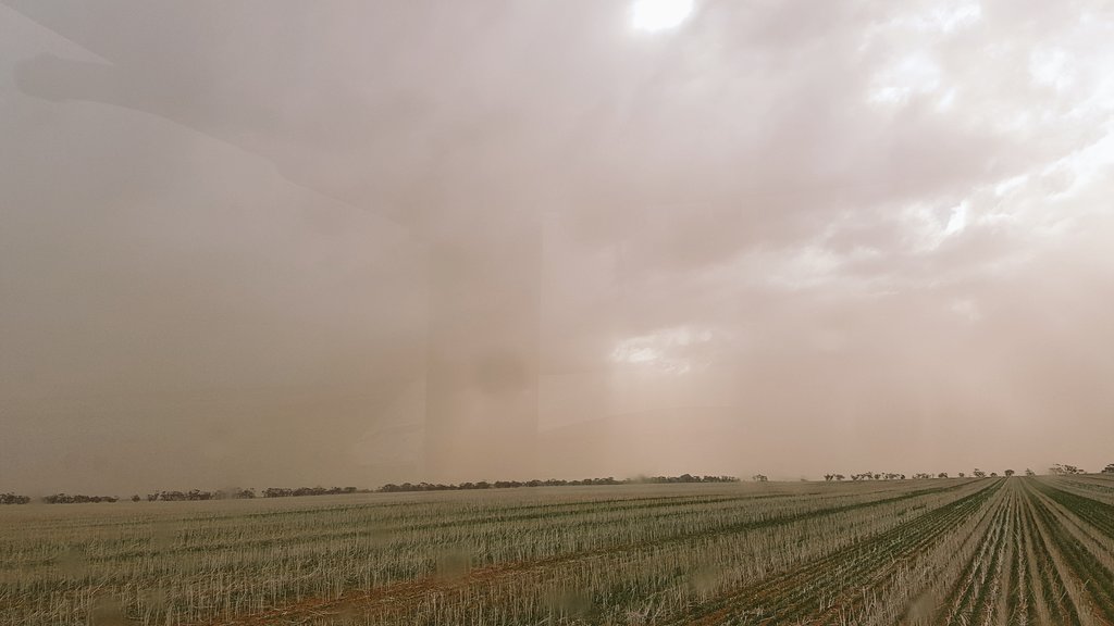
Showing how drynthings are there were a few small bushfires out west and a dust storm at Mildura

A photo of the dust storm in the Mallee.
Couple of briefly warned fires also, one in Gippsland and the other the Mallee. I’ve never seen that in July before
Re: VICTORIA - Sequence of fronts: July 16-24 2018
Posted: Tue Jul 17, 2018 8:04 pm
by snowfall
I wasn't here today to see the wind, but thankfully haven't noticed any damage. 3.2mm from the squall line, which must have been heavy judging from the radar, but fairly brief. A line of showers just passed through a few moments ago, but were weakening rapidly, so only a sprinkling in the end. Currently 7.6c here.
Re: VICTORIA - Sequence of fronts: July 16-24 2018
Posted: Wed Jul 18, 2018 10:45 am
by occluded
Yesterday morning was actually relatively pleasant with full sunshine and 17 degrees by early afternoon.
Only a couple of mm with that squall line yesterday afternoon - was all over very quickly.
Plenty of large wind gusts on the AWS especially when the squall line came through - a number of large tree branches / trees down through Doncaster East and Warrandyte made for a late night.
Re: VICTORIA - Sequence of fronts: July 16-24 2018
Posted: Wed Jul 18, 2018 11:56 am
by StratoBendigo
We ended up with 2mm. A cold start with a pea-souper fog this morning. Sunny now but just 10 degC.
Tomorrow night's front looks rather cold and damp. Really chilly upper temps Friday morning are expected, then more frosty mornings on the weekend

Re: VICTORIA - Sequence of fronts: July 16-24 2018
Posted: Wed Jul 18, 2018 12:29 pm
by Gordon
6.5mm for us, so a handy fall. Brings us to 32mm mtd, so ticking along okay. Another cold but mostly dry day today.
July temps are running slightly below average, as they did for June.
Wind speeds map from BOM yesterday:

Re: VICTORIA - Sequence of fronts: July 16-24 2018
Posted: Wed Jul 18, 2018 12:59 pm
by StratoBendigo
Gordon wrote: ↑Wed Jul 18, 2018 12:29 pm
6.5mm for us, so a handy fall. Brings us to 32mm mtd, so ticking along okay. Another cold but mostly dry day today.
July temps are running slightly below average, as they did for June.
Wind speeds map from BOM yesterday:
141 km/h at Wilson's Prom. Just a bit blowy. (Ranks as a 12 - Hurricane force on the Beaufort Scale)
Re: VICTORIA - Sequence of fronts: July 16-24 2018
Posted: Wed Jul 18, 2018 6:55 pm
by hillybilly
Cool sunny one here today with a max of 9C. Tomorrow looks quite mild but cloud and wind building with a solid rainband later. Gfs and EC both showing fairly widespread 5-15mm falls so a bit in it
Second followup front for Friday, tending to be a bit more coastally focused but should still deliver a bit.
That wind maps is impressive

Re: VICTORIA - Sequence of fronts: July 16-24 2018
Posted: Thu Jul 19, 2018 5:23 am
by StratoBendigo
Looks like another "4 seasons in one day" today.
One of the notable things about this month is the large diurnal range. Quite a few locations in NSW might end up recording their coldest July mean min and warmest July mean max in the same month! Case in point is Penrith which is running 2c below avg for min, and 2c above avg for max.
We're on about 1c below min, 1c above max and the forecast into next week indicates this will expand.
Re: VICTORIA - Sequence of fronts: July 16-24 2018
Posted: Thu Jul 19, 2018 7:58 am
by flyfisher
"One of the notable things about this month is the large diurnal range."
Yep, that's a drought signature. We might as well be living on the Moon currently, just cut off from tropical moisture. The Indian ocean is so important to our winter rains, much for than ENSO.
Re: VICTORIA - Sequence of fronts: July 16-24 2018
Posted: Thu Jul 19, 2018 8:00 am
by Tassiedave
Rain in Tas since 9am Wed: Lake Gwendy 79mm, Mt Victoria 62mm, Cradle Valley 61mm, Warra 60mm, Mt Barrow 42mm, Strahan 33mm, Deloraine 19mm, Ross 17mm, Hobart 7.6mm, Launceston 5.6mm,