Think your estimation of 30mm is a little high for this week DJ but things can change. Perhaps 10-20mm is much more reasonable as the SW winds are cold and dry IMO.
That low passing over N VIC is interesting and if it can swing south it could indeed bring better falls again for northern VIC and the flood zones. Probably not what they want but still continuing the trend of wetter and cooler conditions here in the SE this week.
No 20C weather in sight.

Welcome New Members! We want to hear from you. Register, stop lurking and start posting!
Victoria - Series of fronts - September 12-20 2010
-
Karl Lijnders

- Tornadic Supercell
- Reactions:
- Posts: 5771
- Joined: Sun Nov 22, 2009 11:17 pm
- Location: Knoxfield, Victoria
Re: Series of fronts, Sept 12-20
Former Owner - The Australian Weather Forum. Email me anytime - weatherman1000@hotmail.com
- droughtbreaker
- Supercell
- Reactions:
- Posts: 2844
- Joined: Wed Nov 25, 2009 7:50 pm
- Location: Mount Macedon, VIC, 520m asl
Re: Series of fronts, Sept 12-20
Back to a relatively dry pattern now. It will be cold and showery for the most part but no major rainfall or renewed flooding which is good news really because we should be returning to very wet conditions in the coming months and we don't want rivers to reach ever increasing high levels with each rainfall event.
Not expecting much excitement here but as David says it should build up into something half decent over the days.
Not expecting much excitement here but as David says it should build up into something half decent over the days.
-
Karl Lijnders
- Tornadic Supercell
- Reactions:
- Posts: 5771
- Joined: Sun Nov 22, 2009 11:17 pm
- Location: Knoxfield, Victoria
Re: Series of fronts, Sept 12-20
Doesn't look great for southern areas. Better for northern areas on Monday/Tuesday with rain areas and some thunderstorms about moving through to the NE on Tuesday with falls of 20-30mm likely here.
Southern areas have to wait till about Wednesday when a strong cold front comes in but there will be a lot of dry cold air so not much precip. Maybe up to 10mm in southern areas at best over 3 days.
Looks like something pretty large will develop over SE QLD and N NSW later in the period and could work it's way down as the high moves under TAS.
Former Owner - The Australian Weather Forum. Email me anytime - weatherman1000@hotmail.com
-
Petros

- Supercell
- Reactions:
- Posts: 2001
- Joined: Tue Dec 01, 2009 6:25 pm
- Location: Maffra, Gippsland, Vic
Re: Series of fronts, Sept 12-20
Not much agreeance between models, and as stated in the expired thread - we have EC for 3 runs now still progging a closed low over N Vic for 12 hours on Tuesday. The only model running with this. As karl said, one to watch for NE Vic wet areas. I will be watching it closely too.
.... and out a week, significant rain chances for central QLd ranges?? Its all good.
.... and out a week, significant rain chances for central QLd ranges?? Its all good.
- Jake Smethurst
- Supercell
- Reactions:
- Posts: 3583
- Joined: Mon Nov 23, 2009 8:49 pm
- Location: Cheltenham
Re: Series of fronts, Sept 12-20
At this point in time, I think western Victoria could be in for a surprise regarding thunderstorm activity on Monday. I am keeping a close eye on it, but it may get interesting. Not promising anything though as models are still very choppy ... however I have made my thunderstorm charts (see link in signature) ... just note that these will probably change by Monday.
Jake - Senior AWF Forecaster
Feel free to send me a private message if you have any questions.
Feel free to send me a private message if you have any questions.
-
AUSSKY

- Storm Chaser
- Reactions:
- Posts: 538
- Joined: Wed Nov 25, 2009 11:59 pm
- Location: Trentham (700m ASL)
- Contact:
Re: Series of fronts, Sept 12-20
wouldn't be surprised to get some snow in the central ranges from this ......currently 6.6C - too warm for me - I'd like winter back thanks!
Australian Sky & Weather (AUSSKY)
Victoria - The State of Drizzle & Occasional Tornadoes
(1999 -2016)
Victoria - The State of Drizzle & Occasional Tornadoes
(1999 -2016)
-
Karl Lijnders
- Tornadic Supercell
- Reactions:
- Posts: 5771
- Joined: Sun Nov 22, 2009 11:17 pm
- Location: Knoxfield, Victoria
Re: Series of fronts, Sept 12-20
Well that would be a nice suprise indeed. Falls of 20-30mm hugging the ranges and coming in early on Monday so there is a good shot at it.
Winter not over yet by any means,
Sitting on 6C here with a NE breeze. Might sneak a 20C today in the CBD but elsewhere we will have to wait.
Winter not over yet by any means,
Sitting on 6C here with a NE breeze. Might sneak a 20C today in the CBD but elsewhere we will have to wait.
Former Owner - The Australian Weather Forum. Email me anytime - weatherman1000@hotmail.com
- I_Love_Storms
- Supercell
- Reactions:
- Posts: 2812
- Joined: Wed Dec 02, 2009 2:01 pm
- Location: Hawthorn
Re: Series of fronts, Sept 12-20
This weather is great. After 12 years of drought or more and very low rainfalls and above average temps we are definitely now back to a more normalised pattern. I'm glad we haven't seen any blocking highs etc. that were evident in other years and even last winter where temps were well above average and rainfalls were very low.
I really do hope this continues and we have another monster storm season down here.
These series of fronts are just another entree of what's to come.
I really do hope this continues and we have another monster storm season down here.
These series of fronts are just another entree of what's to come.
Re: Series of fronts, Sept 12-20
Gday ILS, to be honest mate there actually is a block coming this week a huge massive high sitting underneath WA for a week or so but thankfully for us its to our advantage getting a high there ( I know Perth won't see it that way though) it means cool to cold weather for us and wet weather at times, if this high were to have happend in the Tasman sea we would be looking at temps of mid to high 20's in Melbourne and 30c wouldn't be out of realms of possibilty either mate for a week
Re: Series of fronts, Sept 12-20
as much as this rain is good and everything i would love some sun...seems most days are still overcast here with only the occasional glimpse of light...feel very sun deprived the last 6 months
- Jake Smethurst
- Supercell
- Reactions:
- Posts: 3583
- Joined: Mon Nov 23, 2009 8:49 pm
- Location: Cheltenham
Re: Series of fronts, Sept 12-20
Quite a bit of convection around here this morning, and some of it growing nicely and extending to my northwest. Latest Visual shows most of it to be over southwest Victoria. Not likely to do anything though I don't think. Nice and warm though here!
Tomorrow still looking quite good for thunderstorms, particularly western Victoria. More on that later.
Tomorrow still looking quite good for thunderstorms, particularly western Victoria. More on that later.
Jake - Senior AWF Forecaster
Feel free to send me a private message if you have any questions.
Feel free to send me a private message if you have any questions.
Re: Victoria - Series of fronts - September 12-20 2010
Thunderstorms Jake? I'll be suprised if theres rain about tomorrow let alone thunderstorms mate. Time will tell.
-
typhoon29

- Cumulonumbus Calvas
- Reactions:
- Posts: 510
- Joined: Fri Jan 01, 2010 11:05 pm
- Location: Ballarat (Mitchell Park)
- Contact:
Re: Victoria - Series of fronts - September 12-20 2010
Yes Jake some nice Cu development here too, sun+moist(wet) ground= convection. Had a brief shower too. Mild and a tad humid with a coollish NW wind. Interesting NW cloud mass streaming down from WA just entereing NW Vic. Tomorrow will be interesting.....
Ballarat, Home of the Anti-Thunderstorm Shield!
- Jake Smethurst
- Supercell
- Reactions:
- Posts: 3583
- Joined: Mon Nov 23, 2009 8:49 pm
- Location: Cheltenham
Re: Victoria - Series of fronts - September 12-20 2010
Yes John, I have had the feeling that tomorrow could be interesting for a few days. I am no expert at thunderstorm prediction, but am getting there with the help of numerous people. Who knows, tomorrow there could be nothing after all, but unless models change rapidly tonight, at this stage I am expecting at least isolated thunderstorms over the west tomorrow afternoon. Moisture profile looks good, 0-6 KM sheer good, some good instability and we have the trigger in a way of a trough. Surface temperatures is the limiting factor statewide. As I said last night, could get interesting. That is could ... 
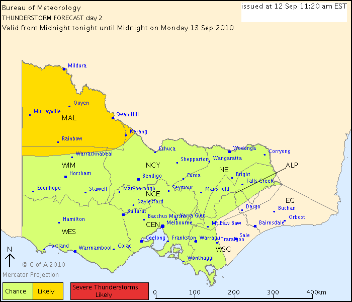
Here is the BoM Thunderstorm Chart for tomorrow below. I think by tomorrow it would have changed a little with the 'yellow' area more widespread over the west. Anyway, at least it shows they are interested too.
Australian Government Bureau of Meteorology
Victoria Regional Office
DAY 2 THUNDERSTORM FORECAST
Issued at 11:20 am Sunday, 12 September 2010,
Valid from midnight tonight until midnight on Monday, 13 September 2010.
Isolated thunderstorms are possible over a lot of Victoria on Monday with the passage of a trough and weak low pressure system. Thunderstorms are most likely during the afternoon and evening, and much more likely over the northwest of the state than elsewhere. The risk is quite low south of the ranges, and would require higher moisture levels than are anticipated. There is the risk of severe thunderstorms developing in the northwest of the State in the late afternoon and evening and producing heavy rainfall leading to flash flooding due to high moisture levels and the likelihood of slow-moving thunderstorms.
Jake - Senior AWF Forecaster
Feel free to send me a private message if you have any questions.
Feel free to send me a private message if you have any questions.
Re: Victoria - Series of fronts - September 12-20 2010
I agree with the storms being a good chance in the NW but I hardly see anything happening for down here and SW Vic
-
Karl Lijnders
- Tornadic Supercell
- Reactions:
- Posts: 5771
- Joined: Sun Nov 22, 2009 11:17 pm
- Location: Knoxfield, Victoria
Re: Victoria - Series of fronts - September 12-20 2010
I am with John on this one. The BoM are holding onto they're initial forecasts from Friday and winding them back gradually everyday. There will be little in S VIC tomorrow, but that said looking across in S WA there is a lot of rainfall so it is certainly not over yet for us down here.
Good rainfall likely in the NW giving them probably one of the wettest Septembers in a very long time. Good times.
Good rainfall likely in the NW giving them probably one of the wettest Septembers in a very long time. Good times.
Former Owner - The Australian Weather Forum. Email me anytime - weatherman1000@hotmail.com
Re: Series of fronts, Sept 12-20
This probably belongs in a future thread but just on this subject, current model runs suggest a classic split-flow setup at 500hpa developing south of WA by midweek favouring a big persistent blocking high (progged to be >1040 hpa) creeping into the Bight. Latest runs have it almost stationary or retrogressing west a bit near the weekend and hovering there right into the middle of next week (with the strongly positively tilted belt of cold air on its eastern flank over the southern parts of the continent until later this week).johnno wrote:Gday ILS, to be honest mate there actually is a block coming this week a huge massive high sitting underneath WA for a week or so
Ken.
-
Karl Lijnders
- Tornadic Supercell
- Reactions:
- Posts: 5771
- Joined: Sun Nov 22, 2009 11:17 pm
- Location: Knoxfield, Victoria
Re: Victoria - Series of fronts - September 12-20 2010
Yes and there is a significant chance of seeing continued below average temps, showery conditions and snowfalls for VIC in this period. Not huge amounts but as DJ initially pointed out at the start of the thread this could add up to something reasonable and now be back to initial prognostics.
Interesting that the low pressure system over N VIC seems to be washing out a little however still a 10-25mm along the N border.
Scattered showers forming throughout the state at the moment may dump a couple of mm over the ranges.
Interesting that the low pressure system over N VIC seems to be washing out a little however still a 10-25mm along the N border.
Scattered showers forming throughout the state at the moment may dump a couple of mm over the ranges.
Former Owner - The Australian Weather Forum. Email me anytime - weatherman1000@hotmail.com
- droughtbreaker
- Supercell
- Reactions:
- Posts: 2844
- Joined: Wed Nov 25, 2009 7:50 pm
- Location: Mount Macedon, VIC, 520m asl
Re: Victoria - Series of fronts - September 12-20 2010
The Bendigo fall is actually from this band passing through right now, Redesdale now has 2.2mm so that can be added to the list.
Looks like we're going to just miss out on the best of it here.
I actually reckon it will be quite convective tomorrow. Not necessarily thunderstorms down here but quite a few slow moving showers and some may be heavy. If we can get a decent band in northern and north central VIC on nightfall today when nothing was forecast at all then tomorrow with more of a trigger and a better setup in general plus daytime heating should be half decent for some IMHO.
- Jake Smethurst
- Supercell
- Reactions:
- Posts: 3583
- Joined: Mon Nov 23, 2009 8:49 pm
- Location: Cheltenham
Re: Victoria - Series of fronts - September 12-20 2010
I am sticking with what I said earlier and predicting isolated afternoon thunderstorms over the western and northern districts. I have not seen the latest Stormcast due to a problem with it not updating, however looking at the showers across the state now, some locally heavy, tomorrow should be better with more of them and better convection. Trigger close by, good moisture levels, should be enough in the surface temps, cold uppers and 0-6 KM sheer is good. Time will tell ... and if nothing happens, well I'm an idiot!!
Jake - Senior AWF Forecaster
Feel free to send me a private message if you have any questions.
Feel free to send me a private message if you have any questions.