Welcome New Members! We want to hear from you. Register, stop lurking and start posting!

TC Laurence. December 10th-23rd 2009

Archived Weather Events since 2009.
If you have any valuable content to add to any locked thread, please PM board moderator.
J
Jake Smethurst
Supercell
Reactions:
Posts: 3583
Joined: Mon Nov 23, 2009 8:49 pm
Location: Cheltenham

Re: TC Laurence. December 10th-??? 2009

Post by Jake Smethurst »

Yeah nice pick up Anthony! ;)

I am hopeing we get some storms next week, as for the 2 weeks after that, I will not have internet access at the place I am staying at for work on the radio.

BTW, good to see Laurence remain fairly strong despite being over land. It's taking him a while to weaken.
Jake - Senior AWF Forecaster
Feel free to send me a private message if you have any questions.
User avatar
Karl Lijnders
Tornadic Supercell
Reactions:
Posts: 5771
Joined: Sun Nov 22, 2009 11:17 pm
Location: Knoxfield, Victoria

Re: TC Laurence. December 10th-??? 2009

Post by Karl Lijnders »

Excellent call Anthony, you have been spot on with this.

Should now see significant rain and storm events arise from this cyclone, Christmas and New Years. 20-50mm each time.
Former Owner - The Australian Weather Forum. Email me anytime - weatherman1000@hotmail.com
j
johnno
Supercell
Reactions:
Posts: 3449
Joined: Mon Nov 30, 2009 8:49 am
Location: Ascot Vale

Re: TC Laurence. December 10th-??? 2009

Post by johnno »

Yeah I was telling Karl yesterday morning that this system won't go East and EC was confused yesterday morning andwill eventually come down bringing closer to us so I'm not suprised at all suddenly its in our neck of the woods just a matter of when it will come down.
User avatar
AUSSKY
Storm Chaser
Reactions:
Posts: 538
Joined: Wed Nov 25, 2009 11:59 pm
Location: Trentham (700m ASL)
Contact:

Re: TC Laurence. December 10th-??? 2009

Post by AUSSKY »

...and quite possibly some flooding!!!
Australian Sky & Weather (AUSSKY)
Victoria - The State of Drizzle & Occasional Tornadoes
(1999 -2016)
User avatar
Blackee
Site Admin/Moderator
Reactions:
Posts: 3857
Joined: Tue Nov 24, 2009 8:57 pm
Location: Elwood and Mansfield 370m

Re: TC Laurence. December 10th-??? 2009

Post by Blackee »

Latest track map has seen Laurence travel more SE than S, which will spare Derby somewhat. Forecast track is still having Laurence downgraded to a low by this time tomorrow and heading back out to the Indian Ocean, giving Broome a nice dumping on the way.
Mansfield 370m and Elwood
User avatar
Anthony Violi
Supercell
Reactions:
Posts: 2652
Joined: Mon Nov 23, 2009 9:03 pm
Location: Lilydale
Contact:

Re: TC Laurence. December 10th-??? 2009

Post by Anthony Violi »

thanks guys...Something I always keep in mind is that when I see cyclones models can only be relied on as a guide only. Every 12 hours they need to realign themselves as cyclones really don't care for models. So I always go with logic, and logic told me that with a general Sw tendency for the next 4 days would see it be on the western side of the ridge and be forced South or SE. Also if anything at that latitude winds would almost be Easterly forcing it southward. Anyway let's see it happenfirst before we get to excited as Laurence is not one to go to the script so far.
http://www.therealworldweatherforum.com" onclick="window.open(this.href);return false;

avweatherforecasts.com
j
johnno
Supercell
Reactions:
Posts: 3449
Joined: Mon Nov 30, 2009 8:49 am
Location: Ascot Vale

Re: TC Laurence. December 10th-??? 2009

Post by johnno »

Yeah could end up going to Our West then south but all honesty can't see that happen but as you say anything is possible with cyclones
User avatar
Blackee
Site Admin/Moderator
Reactions:
Posts: 3857
Joined: Tue Nov 24, 2009 8:57 pm
Location: Elwood and Mansfield 370m

Re: TC Laurence. December 10th-??? 2009

Post by Blackee »

TC Laurence has slowed to a walk but still continues as a Cat1 cyclone. It's longevity over land has been impressive.
Mansfield 370m and Elwood
User avatar
Karl Lijnders
Tornadic Supercell
Reactions:
Posts: 5771
Joined: Sun Nov 22, 2009 11:17 pm
Location: Knoxfield, Victoria

Re: TC Laurence. December 10th-??? 2009

Post by Karl Lijnders »

It is certainly seeing some intense rainfall over parts of the NW Coast. 200mm falls in the Kimberley region. Up to 300mm at Troughton Island where heavy where heavy rain still falls. That region around the Mitchell Plateau has had 500mm+ from this system and it is not done with yet.

Should see another 200-300mm in the region over the weekend as the TC moves offshore. Next in line is Broome.
Former Owner - The Australian Weather Forum. Email me anytime - weatherman1000@hotmail.com
User avatar
Anthony Violi
Supercell
Reactions:
Posts: 2652
Joined: Mon Nov 23, 2009 9:03 pm
Location: Lilydale
Contact:

Re: TC Laurence. December 10th-??? 2009

Post by Anthony Violi »

Well its really dependant on the next 2 days as to our chances for a massive event between Xmas and new years. I expect Xmas Eve will be just average in terms of rainfall. Laurence i think will do the right thing and stay out to the West of the ridge, even though this morning Ec sends him East again and washes it out..this may well happen this time, as last time it forecast this it was totally illogical.

However, if in the next 2 days he can edge further South, say below PH, then i think that changes everything. And even if that happens, there may be no system to link up with of any substance. And im hoping he slows down as he has sped up the last 48 hours, slowing down allows him to hopefully go down the western flank of the ridge. Anyhow, critical 48 hours for both scenarios.
http://www.therealworldweatherforum.com" onclick="window.open(this.href);return false;

avweatherforecasts.com
User avatar
Karl Lijnders
Tornadic Supercell
Reactions:
Posts: 5771
Joined: Sun Nov 22, 2009 11:17 pm
Location: Knoxfield, Victoria

Re: TC Laurence. December 10th-??? 2009

Post by Karl Lijnders »

TOP PRIORITY FOR IMMEDIATE BROADCAST

TROPICAL CYCLONE ADVICE NUMBER 62
Issued at 5:50 am WST on Saturday, 19 December 2009
BY THE BUREAU OF METEOROLOGY
TROPICAL CYCLONE WARNING CENTRE PERTH

A Cyclone WARNING continues for coastal areas from Cape Leveque to Bidyadanga.

A Cyclone WATCH continues for coastal areas from Bidyadanga to Pardoo.

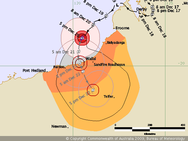
At 5:00 am WST Ex-Tropical Cyclone Laurence was estimated to be
145 kilometres north northeast of Broome and moving
west northwest at 12 kilometres per hour.

Ex-Tropical Cyclone Laurence has moved over the Dampier Peninsula and crossed
the west Kimberley coast.

The low is expected to reintensify into a tropical cyclone in the next three to
six hours. GALES could develop along the west Kimberley coast between Cape
Leveque and Bidyadanga, including Broome during the morning. As the system moves
south westwards GALES could extend further down the coast to Pardoo late on
Sunday.

Heavy rainfall is expected to continue in the west Kimberley with 24 hour falls
in excess of 200mm possible. Curtin has reported 142mm since 9am Friday.


FESA-State Emergency Service advises as a precautionary measure the following
community alerts:
BLUE ALERT: People in the communities from Cape Leveque to Beagle Bay, including
One Arm Point, Djarindjin and Lombadina need to prepare for cyclonic weather and
organise an emergency kit including first aid kit, torch, portable radio, spare
batteries, food and water.
Communities in the remainder of the western Kimberley and northern Pilbara
should listen for the next advice.


Details of Ex-Tropical Cyclone Laurence at 5:00 am WST:
.Centre located near...... 16.7 degrees South 122.5 degrees East
.Location accuracy........ within 35 kilometres
.Recent movement.......... towards the west northwest at 12 kilometres per hour
.Wind gusts near centre... 85 kilometres per hour
.Severity category........ below cyclone intensity
.Central pressure......... 996 hectoPascals

The next advice will be issued by 9:00 am WST Saturday 19 December.Cyclone
advices and State Emergency Service Community Alerts are available by
dialling 1300 659 210


A map showing the track of the cyclone is available at:
http://www.bom.gov.au/weather/cyclone
Former Owner - The Australian Weather Forum. Email me anytime - weatherman1000@hotmail.com
User avatar
Karl Lijnders
Tornadic Supercell
Reactions:
Posts: 5771
Joined: Sun Nov 22, 2009 11:17 pm
Location: Knoxfield, Victoria

Re: TC Laurence. December 10th-??? 2009

Post by Karl Lijnders »

The TC moves quite a fair way offshore in the coming 24hrs and develops in to a Cat 3 by Monday morning. Seems like it is going to be caught up on the western side of the ridge which makes the latest US rainfall track more understandable.

Anyhow by Tuesday I can see this crossing the coast or coming nearer the coast as a 5. Could be another Tracey for one of the unlucky communities along the NW coast.
Former Owner - The Australian Weather Forum. Email me anytime - weatherman1000@hotmail.com
User avatar
Karl Lijnders
Tornadic Supercell
Reactions:
Posts: 5771
Joined: Sun Nov 22, 2009 11:17 pm
Location: Knoxfield, Victoria

Re: TC Laurence. December 10th-??? 2009

Post by Karl Lijnders »

Napier Downs had 402mm the previous 24hrs to 9am. That rain focus has shifted west towards the coast with 100-200mm over Curtain and Derby. Insane rainfall.
Former Owner - The Australian Weather Forum. Email me anytime - weatherman1000@hotmail.com
J
Jake Smethurst
Supercell
Reactions:
Posts: 3583
Joined: Mon Nov 23, 2009 8:49 pm
Location: Cheltenham

Re: TC Laurence. December 10th-??? 2009

Post by Jake Smethurst »

And Laurence is now a cyclone again, category 1. ;)
Jake - Senior AWF Forecaster
Feel free to send me a private message if you have any questions.
J
Jake Smethurst
Supercell
Reactions:
Posts: 3583
Joined: Mon Nov 23, 2009 8:49 pm
Location: Cheltenham

Re: TC Laurence. December 10th-??? 2009

Post by Jake Smethurst »

Laurence strengthening quite quickly with the warm waters off the NW coast. Now at a category 2 stage.
Jake - Senior AWF Forecaster
Feel free to send me a private message if you have any questions.
User avatar
Blackee
Site Admin/Moderator
Reactions:
Posts: 3857
Joined: Tue Nov 24, 2009 8:57 pm
Location: Elwood and Mansfield 370m

Re: TC Laurence. December 10th-??? 2009

Post by Blackee »

Jake, the SST's are perfect for strengthening any system. Track chart suggests an upgrade from Cat3 to Cat4 within 12 hour tonight, and moving less than 100kms. SST's drop marginally the closer he moves to the coast, thus the chance of returning to a Cat5 as less of a chance, however not without a chance. Port Hedland appears to have luck on its side this time, just gales and rain, no direct or near direct hit. Wallal is a different story.
Mansfield 370m and Elwood
J
Jake Smethurst
Supercell
Reactions:
Posts: 3583
Joined: Mon Nov 23, 2009 8:49 pm
Location: Cheltenham

Re: TC Laurence. December 10th-??? 2009

Post by Jake Smethurst »

Yeah very warm mate! BoM upgraded the system to a severe category 3 with the latest update. Wallal is expected to pretty much get a direct hit still, the cyclone just nudges the town.
Jake - Senior AWF Forecaster
Feel free to send me a private message if you have any questions.
User avatar
Karl Lijnders
Tornadic Supercell
Reactions:
Posts: 5771
Joined: Sun Nov 22, 2009 11:17 pm
Location: Knoxfield, Victoria

Re: TC Laurence. December 10th-??? 2009

Post by Karl Lijnders »

Getting close to a landfall. Next 24hrs of final movement over water could prove interesting for Pardoo - Wallall into Telfar. Nervous residents there no doubt!!

Image
Former Owner - The Australian Weather Forum. Email me anytime - weatherman1000@hotmail.com
User avatar
Blackee
Site Admin/Moderator
Reactions:
Posts: 3857
Joined: Tue Nov 24, 2009 8:57 pm
Location: Elwood and Mansfield 370m

Re: TC Laurence. December 10th-??? 2009

Post by Blackee »

Laurence up to a Cat 4 now, strengthening from a Cat 3 in 9 hours!!!
Wont go to a Cat 5 (not enough time), however 230km/h winds will cause enough problems!!
Great view of the eye and movement on the 256km Port Hedland radar.
Mansfield 370m and Elwood
User avatar
Karl Lijnders
Tornadic Supercell
Reactions:
Posts: 5771
Joined: Sun Nov 22, 2009 11:17 pm
Location: Knoxfield, Victoria

Re: TC Laurence. December 10th-??? 2009

Post by Karl Lijnders »

It will get to a 5 IMHO.
Former Owner - The Australian Weather Forum. Email me anytime - weatherman1000@hotmail.com
Locked