Page 1 of 7
Cold outbreak 3 August - ?
Posted: Thu Jul 30, 2020 3:52 pm
by Gordon
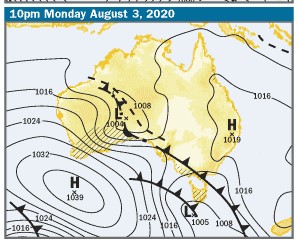
After being tossed around by the models for a few days (particularly GFS) what looks like a burst of very cold weather and low level snow is finally showing up on the BOM 4 day charts:

Time will tell how much snow falls and where, but as it's only 4 days out, a new thread seems appropriate!
Re: Cold outbreak 3 August - ?
Posted: Thu Jul 30, 2020 6:32 pm
by Gordon
Updated MetEye has snow for us most of Tuesday and into Wednesday morning. Very unusual for MetEye to forecast low snow that far out - and for that duration.
Eastern Vic also looks due for some.
Re: Cold outbreak 3 August - ?
Posted: Thu Jul 30, 2020 8:39 pm
by Sean
There isn't an effective consensus across the models yet, but most of them are showing something at least.
Derwent, your foruntes might change soon. Some models are showing sea-level snow in Hobart, and more than just a flurry.
HOWEVER, lol, we get a sea-level snow event in the charts every year it seems, yet they generally fail to actualize.
But at least something is brewing. This could well be the break in the pattern we've been waiting for.
Re: Cold outbreak 3 August - ?
Posted: Fri Jul 31, 2020 6:18 am
by Didjman
The LWT is finally in the right position for us! Has been a while. Hoping we might get flurries at 328m. Snow in Kilmore used to be a regular winter occurrence. Never had snow at home before.
Re: Cold outbreak 3 August - ?
Posted: Fri Jul 31, 2020 6:20 am
by StratoBendigo
Looks cold still. But I fear that Nthn Vic will miss out on rain due to Tassie rainshadowing, and the later Inland low going too far North.
Axs-G the only exception really as it reckons the Inland low will track into Vic this time next week.
Incidentally, we just had our driest July in 19 years.
Re: Cold outbreak 3 August - ?
Posted: Fri Jul 31, 2020 12:41 pm
by Sean
Is looking less impressive today

Re: Cold outbreak 3 August - ?
Posted: Fri Jul 31, 2020 12:49 pm
by Skywalker
StratoBendigo wrote: ↑Fri Jul 31, 2020 6:20 am
Incidentally, we just had our driest July in 19 years.
Had to start watering some of my outdoor plants today, something unimaginable considering the wet first half of the year we had.
Really hope we get something next week.
Re: Cold outbreak 3 August - ?
Posted: Fri Jul 31, 2020 8:39 pm
by hillybilly
Latest EC and GFS look very good for low level snow, while CMC and UK have a near miss. Would like to see a bit more convergence. It is a really complex dual cyclogenesis situation so still not confident on details.
Re: Cold outbreak 3 August - ?
Posted: Fri Jul 31, 2020 9:36 pm
by Adam38
Only 15mm for July here and June only had 24mm so it’s been very dry so far this winter, I too had to water my native garden this morning...
Re: Cold outbreak 3 August - ?
Posted: Sat Aug 01, 2020 4:15 pm
by hillybilly
Adam38 wrote: ↑Fri Jul 31, 2020 9:36 pm
Only 15mm for July here and June only had 24mm so it’s been very dry so far this winter, I too had to water my native garden this morning...
Wow, that is grim. We’ve had about 215mm which is about 2mm above average. We got really lucky start of July with 50mm of showery swly flow. Some spot north of me scored nearly 100mm, so be running quite a bit above average.
GFS is first model to update, and is icy cold. 850Ts dropping to about -7C. That is comparable with the July 1986 event so cold enough for snow to sea level. Too far out to lock it in that cold, and would like to see all the models line up, but has some real potential. Shame most people will be unable to see it if it does fall properly in the usual cold spots

Re: Cold outbreak 3 August - ?
Posted: Sat Aug 01, 2020 5:14 pm
by Gordon
Yes the cold seems to have intensified if anything - BOM forecast for Central District snow level Tuesday has dropped from 500m to 400m.
Moisture will be the question here. Otways & Strezleckis look very good for a decent fall, although outlier systems like this one, I won't be betting on anything!
Re: Cold outbreak 3 August - ?
Posted: Sat Aug 01, 2020 5:16 pm
by StratoBendigo
Yes, very cold.
But it looks like zero rain here all week. We might be in strife. But signs of good rains mid-August though.
Re: Cold outbreak 3 August - ?
Posted: Sat Aug 01, 2020 5:30 pm
by Sean
If GFS is to be believed, places east of western port bay have a chance of sea-level snow (including much of outskirt Melbourne). You just need to be awake in the early hours of Wed morning to see it, lol.
We'll probably see a good fall at the usual, lower lying spots, e.g. Daylesford, Balarat, Mt Macedon, Warburton, Dandenongs, etc.
Any upgrades from here would make things very interesting.
Re: Cold outbreak 3 August - ?
Posted: Sat Aug 01, 2020 5:55 pm
by Skywalker
It will be my bloody luck that it snows down on the island.
Like many, own a property there & not aloud to travel down there to use it.
Re: Cold outbreak 3 August - ?
Posted: Sat Aug 01, 2020 6:33 pm
by Sean
There's a very slim chance down that way, but it'll most likely be a 400m+ event if history if anything to go by.
Re: Cold outbreak 3 August - ?
Posted: Sun Aug 02, 2020 6:15 am
by hillybilly
Progs look to be holding. Coldest air has two shot. First early Tuesday comes through with a mainly westerly so will focus on the immediate coast, west facing parts of the Great Divide and South Gippsland. As Tuesday progresses a second surge of cold air comes through with more southerly, so showers will be a lot more extensive, continuing into Wednesday.
Snow lines drop well below 500m early Tuesday, rise middle of the day then drop again in the evening. Unfortunately the coldest air and moisture doesn’t quite match up. Early on Tuesday it looks to be cold enough for snow down to near sea level but will be mostly dry. When showers push in the levels will rise towards 500m, give or take.
It looks cold enough for snow in the Dandenongs from early Tuesday to about middle of Wednesday so quite a wide window. Should see some settling. Expecting lots of coldies through the second half of Tuesday with hail, thunder and graupel.
Re: Cold outbreak 3 August - ?
Posted: Sun Aug 02, 2020 6:36 am
by stevco123
hillybilly wrote: ↑Sun Aug 02, 2020 6:15 am
Progs look to be holding. Coldest air has two shot. First early Tuesday comes through with a mainly westerly so will focus on the immediate coast, west facing parts of the Great Divide and South Gippsland. As Tuesday progresses a second surge of cold air comes through with more southerly, so showers will be a lot more extensive, continuing into Wednesday.
Snow lines drop well below 500m early Tuesday, rise middle of the day then drop again in the evening. Unfortunately the coldest air and moisture doesn’t quite match up. Early on Tuesday it looks to be cold enough for snow down to near sea level but will be mostly dry. When showers push in the levels will rise towards 500m, give or take.
It looks cold enough for snow in the Dandenongs from early Tuesday to about middle of Wednesday so quite a wide window. Should see some settling. Expecting lots of coldies through the second half of Tuesday with hail, thunder and graupel.
Sounds a little on par with the August 2005 event. That had to be the most frustrating weather day ever for weather nerds. Almost guaranteed snow conditions for the CBD,yet a westerly flow kept them south.
Re: Cold outbreak 3 August - ?
Posted: Sun Aug 02, 2020 9:14 am
by Australis(Shell3155)
my post code notes..
Tuesday
max 5
min 2
t/storms 90% 1-5mm
got the wood stacked and camera charged
Re: Cold outbreak 3 August - ?
Posted: Sun Aug 02, 2020 1:42 pm
by Didjman
I just noticed "Mares Tails" racing up from the SW. Jetstream is pumping!
Re: Cold outbreak 3 August - ?
Posted: Sun Aug 02, 2020 3:35 pm
by Blackie
Australis(Shell3155) wrote: ↑Sun Aug 02, 2020 9:14 am
my post code notes..
Tuesday
max 5
min 2
t/storms 90% 1-5mm
got the wood stacked and camera charged
Might have to venture up the zig zag to 450m on Wednesday morning!

