Page 4 of 6
Re: Warm and dry weather rolls on: April 17-30?
Posted: Tue Apr 23, 2019 11:31 pm
by Sean
Legend!
Really off topic, but the Millennium Drought years are atrocious. Then bam, 2010 and 2011 strike. Both well above average. 1994 is just about where it starts declining, but which is followed by good years in 1995 and 1996, but then 1997 hits and we only record 360mm for the whole year.
Interesting to note that many of the bountiful years come in twos (La Nina years?). Also, we've only surpassed 900mm 3x since 1856. 2014 and 2015 are both pretty dismal. 2016 and 2017 were decent, both around the 600mm mark.
What's clear, though, is that this below average trend of the 1990s, 2000s and 2010s has no precedence. There are bad years going all the way back to 1856, but they're nowhere near as sustained. I.e. the periods of dry are followed by stretches of average or above average rainfall. 1906 to 1915 comes close, but the dry years aren't as dry, and they're also followed by a very sustained and wet period of above average rainfall.
Re: Warm and dry weather rolls on: April 17-30?
Posted: Wed Apr 24, 2019 5:46 am
by hillybilly
0.2mm here overnight. Currently foggy with a few spits. Looks like a gloomy day with some showers or drizzle. Not a lot in it but with April so dismally dry anything is welcome.
Front on Friday looking like quite a doozie with 850Ts dropping to around -2C, though moisture starved. Could make for a decent fall of snow at Baw Baw etc and frosts inland.
Btw here an update on the Melbourne dry....
https://www.theage.com.au/politics/vict ... 51glb.html
Re: Warm and dry weather rolls on: April 17-30?
Posted: Wed Apr 24, 2019 11:45 am
by StratoBendigo
Sea surface anomalies don't give me much confidence for rain in the coming weeks. Much cooler than average water off WA at present, and looks locked in.
There's going to be some savage frosts this winter IMO.
Re: Warm and dry weather rolls on: April 17-30?
Posted: Wed Apr 24, 2019 2:41 pm
by Dane
Managed to get lucky early this morning. 4.0mm's at Ballarat airport MTD 10.0mm's YTD 42.0mm's.
Driest first 4 months on record is 60.4mm's in the drought year of 1967 so looks like we have that one beaten.
I recorded 4.5mm's up to 9am today taking my MTD to 9.7mm's. Monthly average is 51mm's.
Re: Warm and dry weather rolls on: April 17-30?
Posted: Wed Apr 24, 2019 3:00 pm
by Adam38
Nothing here, sitting on 30mm YTD. I’ve noticed locally, old River Gums are dropping large limbs lately including one that fell on the pub car park.
Re: Warm and dry weather rolls on: April 17-30?
Posted: Wed Apr 24, 2019 5:58 pm
by JasmineStorm
EC going for an early May haymaker. Large cut off upper tropospheric cyclonic vortex that cuts off a surface low over NSW/Vic. It then gets the moisture advection machine cranking off the Tasman into a convergence zone heading into central and Gippsland. Needs a few more runs but other models are also picking up the upper low in a weeks time. Its starting to get volatile

Re: Warm and dry weather rolls on: April 17-30?
Posted: Wed Apr 24, 2019 6:13 pm
by hillybilly
JasmineStorm wrote: ↑Wed Apr 24, 2019 5:58 pm
EC going for an early May haymaker. Large cut off upper tropospheric cyclonic vortex that cuts off a surface low over NSW/Vic. It then gets the moisture advection machine cranking off the Tasman into a convergence zone heading into central and Gippsland. Needs a few more runs but other models are also picking up the upper low in a weeks time. Its starting to get volatile
EC been on/off/on/off/on last few runs. Not much confidence, but does look like a decent prospect (maybe).
Meanwhile, a piddly 0.6mm for us today. Pretty disappointed with that. Was expecting 2-5mm.
Now look to Friday's strong but moisture starved front (which I suspect will be mainly cold and windy). Could well see some raised dust with that one

Maybe a thread next week in which we can talk about real weather, rather than this dismal string of disappointments

Re: Warm and dry weather rolls on: April 17-30?
Posted: Wed Apr 24, 2019 6:34 pm
by JasmineStorm
hillybilly wrote: ↑Wed Apr 24, 2019 6:13 pm
JasmineStorm wrote: ↑Wed Apr 24, 2019 5:58 pm
EC going for an early May haymaker. Large cut off upper tropospheric cyclonic vortex that cuts off a surface low over NSW/Vic. It then gets the moisture advection machine cranking off the Tasman into a convergence zone heading into central and Gippsland. Needs a few more runs but other models are also picking up the upper low in a weeks time. Its starting to get volatile
EC been on/off/on/off/on last few runs. Not much confidence, but does look like a decent prospect (maybe).
With so many false starts in the last 2 months, this set up needs to still exist within 100 hours on every main ensemble to have any confidence
Re: Warm and dry weather rolls on: April 17-30?
Posted: Thu Apr 25, 2019 6:10 am
by Australis(Shell3155)
As much as the rainfall is dismal,
It's a pretty time, the clouds with sun rays sparkling through.
The colouring of the leaves, very pretty, reds yellows and green.
A little moisture, the 5mm Blackie mentioned
And follow ups has seen the talcum turn a tinge of green before your eyes,
What used to be a lake of water then a mud plain then a green tinge in a few showers..
Mansfield had a little yesterday afternoon and upon arriving in Bayswater 4pm if only it had eventuated as it was chunky drops, then they stopped.
Arrived back to FTG and could still see push bike tracks in the dust, nothing I presume in the prior three days to even settle it down,
Enough moisture this morning on tin roof to hear a few drops into the temporary down pipes set up in anticipation.

Re: Warm and dry weather rolls on: April 17-30?
Posted: Thu Apr 25, 2019 9:45 am
by snowfall
0.4mm here yesterday, which takes us up to 3.2mm for the month. We're also tracking about 3c above average for our maximum temperature. Quite a few stressed and dying trees out this way, as well as fields with bare dirt patches and cracked ground. The latest EC run for late next week does look good for Victoria. It's still a long way out, but at least there's something on the horizon even if it's still in theory.
Re: Warm and dry weather rolls on: April 17-30?
Posted: Thu Apr 25, 2019 11:39 am
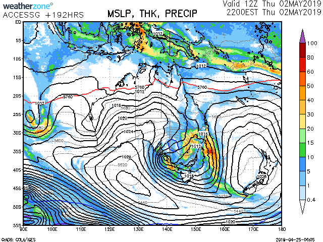
by Gordon
I don't know why I torture myself like this, but ACCESS-G now broadly agrees with EC re a cut-off low over Vic late next week:
Re: Warm and dry weather rolls on: April 17-30?
Posted: Thu Apr 25, 2019 12:46 pm
by StratoBendigo
Gordon wrote: ↑Thu Apr 25, 2019 11:39 am
I don't know why I torture myself like this, but ACCESS-G now broadly agrees with EC re a cut-off low over Vic late next week:
And completely gone on 18Z run. I have very little confidence at present.
Re: Warm and dry weather rolls on: April 17-30?
Posted: Thu Apr 25, 2019 4:12 pm
by tonycynic
Have faith people, there will be rain next weekend. Am doing my first market in 18 months, the last three I did were almost rained out. Expecting the same.
Re: Warm and dry weather rolls on: April 17-30?
Posted: Thu Apr 25, 2019 5:11 pm
by Horts
For those interested.. 20ft at Bells tomorrow for the Rippy!!
Epic day of surfing ahead
Re: Warm and dry weather rolls on: April 17-30?
Posted: Thu Apr 25, 2019 6:33 pm
by hillybilly
Solid front for tomorrow with 850Ts dropping to about -2C and squally swly to wstly winds. Unfortunately moisture starved so showers just near the coast and ranges. Hoping for 5-10mm here, and should see locally near 20mm about the usual wet spots (Otways, Donna Buang, South Gippsland).
EC looks very good for next week, and GFS3 and CMC also onboard. Looks a bit like last year when we went from baking dry and warm/mild to cold and wet with not much proper autumn growing season inbetween

Re: Warm and dry weather rolls on: April 17-30?
Posted: Thu Apr 25, 2019 7:49 pm
by Tassiedave
Tas temps today: Fingal 20.1, Maria Isl 20.0, Friendly Beaches 19.8, Hobart 19.1, Wynyard 18.6, Launceston 18.1 - also Mt Read 26mm of rain
Re: Warm and dry weather rolls on: April 17-30?
Posted: Thu Apr 25, 2019 8:05 pm
by Gordon
StratoBendigo wrote: ↑Thu Apr 25, 2019 12:46 pm
Gordon wrote: ↑Thu Apr 25, 2019 11:39 am
I don't know why I torture myself like this, but ACCESS-G now broadly agrees with EC re a cut-off low over Vic late next week:
And completely gone on 18Z run. I have very little confidence at present.
ACCESS-G looking even better on the latest run??
http://www.weatherzone.com.au/models/
Re: Warm and dry weather rolls on: April 17-30?
Posted: Fri Apr 26, 2019 7:37 am
by Tassiedave
Rainfall overnight in Tasmania: Mt Read 47mm, Cradle Valley 21mm, Reece Dam 19mm, Scottsdale 5.6mm, Low Head 5.6mm, Hobart 1mm
Re: Warm and dry weather rolls on: April 17-30?
Posted: Fri Apr 26, 2019 7:49 am
by occluded
I am pleased to report that we have actual RAIN here. A short sharp band of rain, just in time for the school drop of course.
Re: Warm and dry weather rolls on: April 17-30?
Posted: Fri Apr 26, 2019 7:50 am
by hillybilly
Pouring here and foggy atm, though looks to be short lived
4mm so far.
Cities 3mm makes for the wettest day of the month and nearly double the April total
Now about 15% of the average

Some showers to follow in the cold air.
Looks like locally 10mm about parts of the exposed coast