Page 1 of 1
crikey's weather snaps
Posted: Mon Oct 03, 2011 8:39 pm
by crikey
Went storm chasing today in the comfort of my arm chair.

Travelled to South east Queensland and checked out the storms happening there today
3rd October 2011
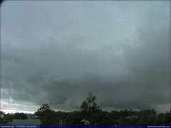
Can anyone tell me if this is a funnel or a tornado in Bellowrie at 4.29pm.
Snap taken from BSCH web cam. I took a series of them but this is the best.
http://webcams.bsch.au.com/" onclick="window.open(this.href);return false;
To view the larger image at flickr click below
" onclick="window.open(this.href);return false;
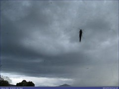
I liked this shot of insect on webcam
Re: crikey's webcam snaps
Posted: Mon Oct 03, 2011 10:31 pm
by Rivergirl
haha love the insect crikey

Someone more knowledgable should be able to answer your question
Re: crikey's webcam snaps
Posted: Mon Oct 03, 2011 10:39 pm
by Meso
Are u referring to the right hand side of the pic? Way too hard to tell with all those trees. Who knows what is behind there. But I suspect it probably just tapers off not too long after the tree line and is just a raggedy bit of cloud at the base of the storm.
Those webcams are great tho. I watched many shelf clouds roll through QLD last summer on there.
Have you discovered the timelapse feature yet?
Re: crikey's webcam snaps
Posted: Mon Oct 03, 2011 11:30 pm
by crikey
You like rivergirl.

My first attempt at photography with someone else's camera/webcam .LOL..I am sure insects wouldn't dare sit on a professionals lens. LOL
Thanks meso for your answer.
Yep. Today was my first storm watch on webcams and l had some understanding of what drives you stormchasers to do what you do . Quite entertaining really and exhilarating if you come across something special.
I did find the timelapse feature and played it this evening.
I captured about 7 snaps and put in them in sequence on slideshow, in photobucket . LOL
Also took my first sky shot locally with my dodgy mobile phone and uploaded .
So all in all, had a fun day, cheers.
Sunday October the 9th 2011, is looking the best day for you professionals for storm chasing in VIC, according to
http://www.bom.gov.au/jsp/watl/wind/index.jsp" onclick="window.open(this.href);return false;
..Have fun..!.and stay safe.

Re: crikey's webcam snaps
Posted: Sat Oct 08, 2011 6:45 pm
by crikey
Snaps of a really good rainshaft near Tamworth NSW today. October 8th 2011 about 3.30pm
Thanks to BSCH webcam
More here( sorry they are not in order..learning photobuckets software. L plates
SLIDE show has better quality
http://s1081.photobucket.com/albums/j34 ... =slideshow" onclick="window.open(this.href);return false;
Re: crikey's webcam snaps
Posted: Fri Oct 14, 2011 8:55 pm
by crikey
14th Oct 2011 Eastern South Australia.. Storms and hail
Took some webcam shots from webcams in SA today looking for some interesting shots
I have posted my favorite three but many more interesting snaps can be viewed from the following links
http://www.imagehosting.com/photo/album ... h-oct-2011" onclick="window.open(this.href);return false;
http://www.flickr.com/photos/crikeyawf/ ... 765682031/" onclick="window.open(this.href);return false;
Sorry about all the links but photobucket annoys me because it often crashes and flickr copyrights the photos. Found Image hosting today which was quicker to work with.
SOUTH FLINDERS RANGES SA..

HAIL STORM
 Check out this from the Whyalla web cam.
Eeerie isn't it. No idea what caused that?

Re: crikey's webcam snaps
Posted: Sun Nov 13, 2011 6:21 pm
by crikey
Hey.. I really like this satellite picture of fields of cumulus growing along a trough line in South Australia. 13th November 2011 6pm Melbourne time.
I Reckon this is really cool!
THe barom pressure around 1003 h pascals in Woomera on the trough line.
The webcam shot is from the Hammond web cam in the Flinders ranges and is a snapshot of the young growing cumulus that may develop into storms as the trough moves eastward in to NSW and Victoria. The trough is an area of low pressure and is often associated with convection because air in a low pressure zone is less dense and rises. As the air heats with solar heating on the land and atmosphere,the air above the land warms and rises. When the rising air parcel reaches cooler altitudes the water content in the rising air parcel condenses into clouds. In this case the rapidly rising air is not only from convective heating but also is assisted by a general region of low pressure. At least that is how l understand it.
 ONE HOUR LATER

Re: crikey's webcam snaps
Posted: Sun Nov 13, 2011 7:33 pm
by Rivergirl
Yes interesting web cam shots for sure crikey
Re: crikey's weather snaps
Posted: Wed Nov 16, 2011 10:24 pm
by crikey
This is a satellite picture of an Interesting weather watch on Tuesday 16th of November 2011.
A cold front pushing up from the south onto the mainland and some moisture laden cloud moving down from the north . The two distinctly different air parcels on a collision course.
Cold moist interfaces with warmer moist air on converging.
I was watching to see if a storm line developed on convergence as the cold air mass pushed up the warm air at the boundary of the two air masses creating convection sufficient to create a storm line. I was not disappointed. I particularly liked this case study as it did not involve trough activity. In fact Adelaide had a Barometer pressure of 1016hpascals and the trough was well to the east in Victoria.
