Welcome New Members! We want to hear from you. Register, stop lurking and start posting!
Victoria: Rain/Storm event: 29th Nov - 5th Dec (Analysis)
-
Supercellimpact

- Supercell
- Reactions:
- Posts: 1241
- Joined: Thu Oct 07, 2010 8:39 pm
- Location: Bendigo
Re: Victoria: Rain/Storm event: 29th Nov - 5th Dec (Analysis
The Lastest Stormcast ( 00z) still had big instability for Friday, but then Tuesday it has HUGE instability 2000+ cape -6 li's. Also rainfall of 100mm for here and central area's and 120+mm for the north east. Some big storms and rainfall ramping up from now until the big day on Tuesday. 
- Harley34
- Cumulonumbus Calvas
- Reactions:
- Posts: 580
- Joined: Sat Mar 06, 2010 1:08 pm
- Location: Ringwood East, Melbourne
Re: Victoria: Rain/Storm event: 29th Nov - 5th Dec (Analysis
Good to see BOM's latest forecast for the next few days have included isolated thunderstorms, and not that "in the north" bs.
I guess that was there uncertainty, but now things are starting to line up. Big storms from tomorrow onwards..
I guess that was there uncertainty, but now things are starting to line up. Big storms from tomorrow onwards..
-
Karl Lijnders

- Tornadic Supercell
- Reactions:
- Posts: 5771
- Joined: Sun Nov 22, 2009 11:17 pm
- Location: Knoxfield, Victoria
Re: Victoria: Rain/Storm event: 29th Nov - 5th Dec (Analysis
Well after todays perfomance we could be up for anything tomorrow.
EC looks magnificent to me, (norweigen looks a little benign but again it had 0.3mm for much of Melbourne today ) with US and ACCESS also supporting sultry and thundery weather ahead of a major rain event next week.
Collectively the models still going for 50-100mm across many places over the state with higher falls.
May see a secondary system develop later next week but still too far off.
EC looks magnificent to me, (norweigen looks a little benign but again it had 0.3mm for much of Melbourne today
Collectively the models still going for 50-100mm across many places over the state with higher falls.
May see a secondary system develop later next week but still too far off.
Former Owner - The Australian Weather Forum. Email me anytime - weatherman1000@hotmail.com
- droughtbreaker
- Supercell
- Reactions:
- Posts: 2844
- Joined: Wed Nov 25, 2009 7:50 pm
- Location: Mount Macedon, VIC, 520m asl
Re: Victoria: Rain/Storm event: 29th Nov - 5th Dec (Analysis
Norwegian site is pretty useless and I still can't believe that it is 100% EC. Maybe some of it is but they get the rest of the information from some other model I guess. Useless for convective rainfall anyway, as EC is generally.
GFS giving us the highest falls, on and north of the ranges and down into Melbourne as well. BOM models looking very lacklustre. Who do we trust?
I reckon GFS is the best bet for the week because of its superior storm forecasting abilities.
General trend suggests heaviest falls will be in the eastern half of the state. Would love to see some big storms here but wouldn't mind a break from it either just to dry things out a little. A big event more than likely in a weeks time that will give widespread big falls anyway.
-
Karl Lijnders
- Tornadic Supercell
- Reactions:
- Posts: 5771
- Joined: Sun Nov 22, 2009 11:17 pm
- Location: Knoxfield, Victoria
Re: Victoria: Rain/Storm event: 29th Nov - 5th Dec (Analysis
I think the worrying thing, a long way off, is if another pool of cold air and upper level low gets flung up from the south over the top of the LWT, as the first system which resolves this time next week, and another low pressure system taps into moisture. That could be truly something out of this world. So so far away but a few models hinting at it.
Anyway, ACCESS has about 100mm next week for many areas of the state after the stormy sequence.
Anyway, ACCESS has about 100mm next week for many areas of the state after the stormy sequence.
Former Owner - The Australian Weather Forum. Email me anytime - weatherman1000@hotmail.com
- HarleyB
- Cumulonumbus Calvas
- Reactions:
- Posts: 839
- Joined: Sun Oct 10, 2010 9:39 pm
- Location: Wangaratta
Re: Victoria: Rain/Storm event: 29th Nov - 5th Dec (Analysis
Don't know how useful the OCF thing is but it has 50mm for here over 2 days early next week. EC upgrades 17% for here also so it should be the start of the model upgrade. Looking forward to getting a direct hit from at least one storm in the next 6 days
-
Anthony Violi

- Supercell
- Reactions:
- Posts: 2652
- Joined: Mon Nov 23, 2009 9:03 pm
- Location: Lilydale
- Contact:
Re: Victoria: Rain/Storm event: 29th Nov - 5th Dec (Analysis
I am pretty sure Norweigan is an ensemble much like OCF isnt it?
In any case, its garbage and has been right very few times. Tomorrow we could see a band of thundery rain dump 30mm across the whole of Vic, let alone the ranges.
Cumulative totals by next week should be up around 40mm statewide at least, before a rain band of monstrous proportions dragging down moisture form the Arctic Ocean. I think if GFS is even half right the whole of Vic will be underwater. All of the models are very bullish so with all the cold air around we could see a historic event, but too early to call.
http://www.therealworldweatherforum.com" onclick="window.open(this.href);return false;
avweatherforecasts.com
avweatherforecasts.com
Re: Victoria: Rain/Storm event: 29th Nov - 5th Dec (Analysis
Storms tomorrow;
What's your take on the situation?
I'm a bit confused as to where my best opportunities lie. There's several potential places which all could be lots of fun, but I'd love your input.
Might sway me one way or another!
What's your take on the situation?
I'm a bit confused as to where my best opportunities lie. There's several potential places which all could be lots of fun, but I'd love your input.
Might sway me one way or another!
-
Anthony Violi
- Supercell
- Reactions:
- Posts: 2652
- Joined: Mon Nov 23, 2009 9:03 pm
- Location: Lilydale
- Contact:
Re: Victoria: Rain/Storm event: 29th Nov - 5th Dec (Analysis
Im tipping you wont have to go far at all tomorrow. The upper low is now moving South and near Hay, will be in the NW tomorrow.
You will be able to see where the bands begin to form early tomorrow as to how far you will need to go.
At this stage it looks like we could get cleaned up tomorrow.
You will be able to see where the bands begin to form early tomorrow as to how far you will need to go.
At this stage it looks like we could get cleaned up tomorrow.
http://www.therealworldweatherforum.com" onclick="window.open(this.href);return false;
avweatherforecasts.com
avweatherforecasts.com
- I_Love_Storms
- Supercell
- Reactions:
- Posts: 2812
- Joined: Wed Dec 02, 2009 2:01 pm
- Location: Hawthorn
Re: Victoria: Rain/Storm event: 29th Nov - 5th Dec (Analysis
Yeah I agree, best bet are similar areas to what got hit today I'd say. We have got reverse topography so anything within a close proximity to the west of the Eastern ranges will probably get hit pretty hard.
-
Karl Lijnders
- Tornadic Supercell
- Reactions:
- Posts: 5771
- Joined: Sun Nov 22, 2009 11:17 pm
- Location: Knoxfield, Victoria
Re: Victoria: Rain/Storm event: 29th Nov - 5th Dec (Analysis
Well I don't know if we could do another 20-50mm fall tomorrow in quick time. We are quickly going under but with rain falling again rather thickly, something tells me that we have no choice in the matter.
EC is by far the best model overall, late in it's run in this example it is rather vague, and leaves the door open to something in the upper levels in our region, where the other models have gone for something much more significant. It is the outlier in that sense and will most likely fall into line and lead the way in progging that sequence.
Anticipating around 20-50mm over the next few days over large parts of the state.
Former Owner - The Australian Weather Forum. Email me anytime - weatherman1000@hotmail.com
- Jake Smethurst
- Supercell
- Reactions:
- Posts: 3583
- Joined: Mon Nov 23, 2009 8:49 pm
- Location: Cheltenham
Re: Victoria: Rain/Storm event: 29th Nov - 5th Dec (Analysis
Storms for tomorrow will be likely in the N Cou, N Cen, C, SW, Wim and Gippsland. Severe storms are more likely in the south, particularly southwest, but also Melbourne.
Jake - Senior AWF Forecaster
Feel free to send me a private message if you have any questions.
Feel free to send me a private message if you have any questions.
- Microburst
- Cumulus
- Reactions:
- Posts: 32
- Joined: Wed Nov 24, 2010 4:31 pm
- Location: Horsham
Re: Victoria: Rain/Storm event: 29th Nov - 5th Dec (Analysis
Well for farming folk in the Western districts tomorrow it sounds like make sure your well insured for hail. Where is that low supposed to head tomorrow is Horsham likely to see severe storms tomorrow?
- I_Love_Storms
- Supercell
- Reactions:
- Posts: 2812
- Joined: Wed Dec 02, 2009 2:01 pm
- Location: Hawthorn
Re: Victoria: Rain/Storm event: 29th Nov - 5th Dec (Analysis
Trough and low supposed to sit west around VIC/SA Border...going to be a wild day.

-
Anthony Violi
- Supercell
- Reactions:
- Posts: 2652
- Joined: Mon Nov 23, 2009 9:03 pm
- Location: Lilydale
- Contact:
Re: Victoria: Rain/Storm event: 29th Nov - 5th Dec (Analysis
Not saying EC isnt the best model, clearly it is...but the Norweigan rainfall does not much up well with synoptics and never has, except for a huge low right over is which is obvious.hillybilly wrote:First two days it's a downscaled version of the EC - ie not the EC. The following days it's the EC modelI am pretty sure Norweigan is an ensemble much like OCF isnt it?
In any case, its garbage and has been right very few times. Tomorrow we could see a band of thundery rain dump 30mm across the whole of Vic, let alone the ranges.
The EC model is the best in the world and the performance of this model has never been better. The second best is UK/ACCESS (they are very similar models). Last week EC had a massive northeast fetch - a set up which is almost unheard of - and if you look at the charts today it was nearly spot on. Without the models we would all be flying blind.
You are wrong to expect a model to predict the rainfall in your back year. Over central areas as a whole today there was less than 5mm on average fall. Some got lucky while most missed out. EC had light falls overall - it forecasts for areas not for points. GFS had LI to -2 today so suggested convective potential and that's exactly what we got.
Looking at EC the next 3 days look great for storms/showers, though picking where and when... GFS suggests the most intense instability will be south of the divide tomorrow with LI to -7 east of Melbourne. With an easterly/northeasterly steering it should get interesting again in Ferny Creek:?:
http://www.therealworldweatherforum.com" onclick="window.open(this.href);return false;
avweatherforecasts.com
avweatherforecasts.com
- Jake Smethurst
- Supercell
- Reactions:
- Posts: 3583
- Joined: Mon Nov 23, 2009 8:49 pm
- Location: Cheltenham
Re: Victoria: Rain/Storm event: 29th Nov - 5th Dec (Analysis
Microburst ... the low is expected to be situated over NW Victoria tomorrow, however the BoM mentioned today that it could even go as far south to sit over Horsham itself. So there is some variance, will have to keep watching the synoptics.
If the low is over Horsham, unlikely to be severe storms, if it's further to the north, then there is likely to be storms, possibly severe. Will update ya in the morning on the where abouts of the low mate.
If the low is over Horsham, unlikely to be severe storms, if it's further to the north, then there is likely to be storms, possibly severe. Will update ya in the morning on the where abouts of the low mate.
Jake - Senior AWF Forecaster
Feel free to send me a private message if you have any questions.
Feel free to send me a private message if you have any questions.
- HarleyB
- Cumulonumbus Calvas
- Reactions:
- Posts: 839
- Joined: Sun Oct 10, 2010 9:39 pm
- Location: Wangaratta
Re: Victoria: Rain/Storm event: 29th Nov - 5th Dec (Analysis
Thank goodness GFS had a huge downgrade, the guys in the north don't need any more rain, Anthony probably wont be too impressed though 
-
Petros

- Supercell
- Reactions:
- Posts: 2005
- Joined: Tue Dec 01, 2009 6:25 pm
- Location: Maffra, Gippsland, Vic
Re: Victoria: Rain/Storm event: 29th Nov - 5th Dec (Analysis
...... we mustnt forgot the flooding potential either, I may be wrong, but I thought my area was the driest in the state over past 6 weeks. 50mm of extra rain in the next 7 days would flood our local region, so the rest of the state must be on the verge of a major flood event as Karl and AV have often said over past week.
Re: Victoria: Rain/Storm event: 29th Nov - 5th Dec (Analysis
Power Storm wrote:Storms for tomorrow will be likely in the N Cou, N Cen, C, SW, Wim and Gippsland. Severe storms are more likely in the south, particularly southwest, but also Melbourne.
Hahahahaha.. Quit sitting on the fence!
-
Petros
- Supercell
- Reactions:
- Posts: 2005
- Joined: Tue Dec 01, 2009 6:25 pm
- Location: Maffra, Gippsland, Vic
Re: Victoria: Rain/Storm event: 29th Nov - 5th Dec (Analysis
Records will be (re) recorded if this ACCESSG scenario comes to play.............
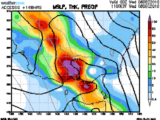
[edit] - sorry, way too early for this thread I just noticed......
[edit] - sorry, way too early for this thread I just noticed......