
Welcome New Members! We want to hear from you. Register, stop lurking and start posting!
Victoria: Low Pressure System Cup Weekend 2010
Re: Victoria: Low Pressure System Cup Weekend 2010
Hi Anthony, can you put the link up GFS rainfall chart? The one I'm looking at (BSCH) isn't working
-
Karl Lijnders

- Tornadic Supercell
- Reactions:
- Posts: 5771
- Joined: Sun Nov 22, 2009 11:17 pm
- Location: Knoxfield, Victoria
Re: Victoria: Low Pressure System Cup Weekend 2010
http://www.weatheronline.co.uk/cgi-bin/ ... =&PERIOD=0
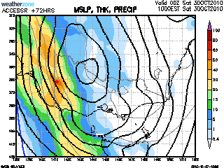
Only goes up to 96hrs tonight due to another glitch...but shows 30-50mm up until that time around Melbourne. 100mm in the NE.
Only goes up to 96hrs tonight due to another glitch...but shows 30-50mm up until that time around Melbourne. 100mm in the NE.
Former Owner - The Australian Weather Forum. Email me anytime - weatherman1000@hotmail.com
Re: Victoria: Low Pressure System Cup Weekend 2010
Thanks Karl, hmm sticks with the big falls through the NE and NW of Melbourne
EDIT: This just updated which is from GFS and looks the same....
http://wxmaps.org/pix/prec7.html" onclick="window.open(this.href);return false;
EDIT: This just updated which is from GFS and looks the same....
http://wxmaps.org/pix/prec7.html" onclick="window.open(this.href);return false;
-
Anthony Violi

- Supercell
- Reactions:
- Posts: 2652
- Joined: Mon Nov 23, 2009 9:03 pm
- Location: Lilydale
- Contact:
Re: Victoria: Low Pressure System Cup Weekend 2010
Yeah i went off the charts Johnno, more rain through the western Central area with a mini wrap starting to take shape.. will increase next day or so to a fully blown cut off..
http://www.therealworldweatherforum.com" onclick="window.open(this.href);return false;
avweatherforecasts.com
avweatherforecasts.com
- Lily
- Supercell
- Reactions:
- Posts: 4014
- Joined: Wed Nov 25, 2009 10:29 pm
- Location: Rowville/Lysterfield
Re: Victoria: Low Pressure System Cup Weekend 2010
Sharon, I've sent you a pm about Eildon, not sure if I can help you hold onto your camping weekend or not, but happy to help out if you think it might work 
-
Karl Lijnders
- Tornadic Supercell
- Reactions:
- Posts: 5771
- Joined: Sun Nov 22, 2009 11:17 pm
- Location: Knoxfield, Victoria
Re: Victoria: Low Pressure System Cup Weekend 2010
EC looks amazing this evening and somewhat more defined with placement. There seems to be some agreement now that W,C and NE areas will be copping a pounding and potentially the E VIC next week but the secondary system will become more defined as the first one develops.
It is quite complex with many factors coming into play for this to come off big time.
Models still not drawing in the low or shortwave which is in W QLD and having any effect on moisture in the region. With the rain not looking likely to enter W VIC till late Friday and C areas Saturday morning, I would suspect a 30C is possible now for much of VIC but this will enhance our chances of seeing thunderstorms developing from the N ahead of the rainband.
In any case, I am still anticipating around 40-70mm here and a good shot at 100mm+ for the sequence.
A nice end to October and we could see November rainfall taken care of by next week!
BTW EC is throwing up a very significant system coming into the region towards next weekend that needs to be watched.
We will post warnings and updates as they come to hand to keep everyone informed on what is going to unfold. A busy time this weekend!!
It is quite complex with many factors coming into play for this to come off big time.
Models still not drawing in the low or shortwave which is in W QLD
In any case, I am still anticipating around 40-70mm here and a good shot at 100mm+ for the sequence.
A nice end to October and we could see November rainfall taken care of by next week!
BTW EC is throwing up a very significant system coming into the region towards next weekend that needs to be watched.
We will post warnings and updates as they come to hand to keep everyone informed on what is going to unfold. A busy time this weekend!!
Former Owner - The Australian Weather Forum. Email me anytime - weatherman1000@hotmail.com
Re: Victoria: Low Pressure System Cup Weekend 2010
Lily wrote:Sharon, I've sent you a pm about Eildon, not sure if I can help you hold onto your camping weekend or not, but happy to help out if you think it might work
Thank you lily, I have sent a reply.
The message didnt come through to my email, is it meant to?
-
Karl Lijnders
- Tornadic Supercell
- Reactions:
- Posts: 5771
- Joined: Sun Nov 22, 2009 11:17 pm
- Location: Knoxfield, Victoria
Re: Victoria: Low Pressure System Cup Weekend 2010
I disagree, but the models are the models and again will bounce around the place. We shall see what they do tomorrow.
One thing that it will be is COLD! Last year we were in a heatwave, this year a protracted cold snap.
Whether we get 40mm or 100mm, it is all good news and bucking the trend of the last 12yrs.
One thing that it will be is COLD! Last year we were in a heatwave, this year a protracted cold snap.
Whether we get 40mm or 100mm, it is all good news and bucking the trend of the last 12yrs.
Former Owner - The Australian Weather Forum. Email me anytime - weatherman1000@hotmail.com
-
stratospear

- Supercell
- Reactions:
- Posts: 1261
- Joined: Sat Dec 19, 2009 9:38 am
- Location: Usually Bendigo
Re: Victoria: Low Pressure System Cup Weekend 2010
It looks like water releases from Hume Dam are being ramped up in expectation of significant inflows this weekend...
Will Lake Eppalock fill this year? It hasn't overflowed since 1996...
I just hope the cropping areas to our north don't get too much rain though.
Will Lake Eppalock fill this year? It hasn't overflowed since 1996...
I just hope the cropping areas to our north don't get too much rain though.
-
Petros

- Supercell
- Reactions:
- Posts: 2001
- Joined: Tue Dec 01, 2009 6:25 pm
- Location: Maffra, Gippsland, Vic
Re: Victoria: Low Pressure System Cup Weekend 2010
Agree the low looks set to form in W Vic Sat, good for Twister!!!!
A lot will change - but I'm BIG TED (and showing my age) about it.
A lot will change - but I'm BIG TED (and showing my age) about it.
-
Karl Lijnders
- Tornadic Supercell
- Reactions:
- Posts: 5771
- Joined: Sun Nov 22, 2009 11:17 pm
- Location: Knoxfield, Victoria
Re: Victoria: Low Pressure System Cup Weekend 2010
That low will move further east across the state to be off the SE coast by Sunday morning. I suspect that models are now finally developing the low and the placement is becoming more NW-SE aligned. UK also shows this up to Saturday morning.
50-100mm over W and C areas looks reasonable and over the NE. Up to 30mm in the SE.
50-100mm over W and C areas looks reasonable and over the NE. Up to 30mm in the SE.
Former Owner - The Australian Weather Forum. Email me anytime - weatherman1000@hotmail.com
-
Didjman

- Supercell
- Reactions:
- Posts: 2100
- Joined: Fri Sep 03, 2010 2:52 pm
- Location: Wallan, Vic 328m ASL
- Contact:
Re: Victoria: Low Pressure System Cup Weekend 2010
I don't think anyone has noticed, but there is another moisture infeed!! Way out in the Indian Ocean. Check out the following link!!
http://www.ssec.wisc.edu/data/geo/index ... thod=flash" onclick="window.open(this.href);return false;
Peter
http://www.ssec.wisc.edu/data/geo/index ... thod=flash" onclick="window.open(this.href);return false;
Peter
- Rhino
- Supercell
- Reactions:
- Posts: 1227
- Joined: Mon Nov 30, 2009 11:37 am
- Location: Carisbrook-Near Maryborough
Re: Victoria: Low Pressure System Cup Weekend 2010
EC really ramping up falls for around my area, 60mm sat-sun, and Ballarat going for 70+mm for the same period but should ease a little with around 30-40mm here IMO on the weekend.
Rhino.
Rhino.
-
typhoon29

- Cumulonumbus Calvas
- Reactions:
- Posts: 510
- Joined: Fri Jan 01, 2010 11:05 pm
- Location: Ballarat (Mitchell Park)
- Contact:
Re: Victoria: Low Pressure System Cup Weekend 2010
so this weekends cricket will hmmm might as well be cancelled now! 
If we get our 50-100mm here floods will be on again. Alas I am going to the inlaws near Hamilton this Friday for the weekend. Probably be driving into the teeth of a squall line of thunderstorms around 6pm~!
will be plenty of work for me come Monday then!
If we get our 50-100mm here floods will be on again. Alas I am going to the inlaws near Hamilton this Friday for the weekend. Probably be driving into the teeth of a squall line of thunderstorms around 6pm~!
will be plenty of work for me come Monday then!
Ballarat, Home of the Anti-Thunderstorm Shield!
- Harley34
- Cumulonumbus Calvas
- Reactions:
- Posts: 580
- Joined: Sat Mar 06, 2010 1:08 pm
- Location: Ringwood East, Melbourne
Re: Victoria: Low Pressure System Cup Weekend 2010
IMO Inner Melbourne areas should see 40-60 mm. Esperance radar look really good at the moment. Models still could toss and turn a little. I'd be watching the Adelaide radar on Friday if anything, that's your best shot to predict IMO. Interesting how on weatherzone's 7-day forecast, Day 7 next Tuesday (Cup Day) has what looks like a tropical cyclone heading towards NW-W W.A (989 hpa), something to watch..
-
Didjman
- Supercell
- Reactions:
- Posts: 2100
- Joined: Fri Sep 03, 2010 2:52 pm
- Location: Wallan, Vic 328m ASL
- Contact:
Re: Victoria: Low Pressure System Cup Weekend 2010
Harley, the TC is alrdy out there!!!!!!!!!!! Look at the link in my previous post:D
Peter
Peter
-
Karl Lijnders
- Tornadic Supercell
- Reactions:
- Posts: 5771
- Joined: Sun Nov 22, 2009 11:17 pm
- Location: Knoxfield, Victoria
Re: Victoria: Low Pressure System Cup Weekend 2010
Yes Peter - models have got that being slingshot from the NW as a sister low SW of Perth is pulled south, the northern one will most likely get caught up in the jetstream and brought SE next weekend but more discussion is in General Weather.
I must say that the cloudband is looking ominous, stuff to the north of NSW is looking very interesting too.
I must say that the cloudband is looking ominous, stuff to the north of NSW is looking very interesting too.
Former Owner - The Australian Weather Forum. Email me anytime - weatherman1000@hotmail.com
- Harley34
- Cumulonumbus Calvas
- Reactions:
- Posts: 580
- Joined: Sat Mar 06, 2010 1:08 pm
- Location: Ringwood East, Melbourne
Re: Victoria: Low Pressure System Cup Weekend 2010
I wonder what the probability of that happening is? I think we are in with a chance, just depends on the location of the Low positioning when it arrives near VIC.typhoon29 wrote:Probably be driving into the teeth of a squall line of thunderstorms around 6pm~!
-
Didjman
- Supercell
- Reactions:
- Posts: 2100
- Joined: Fri Sep 03, 2010 2:52 pm
- Location: Wallan, Vic 328m ASL
- Contact:
Re: Victoria: Low Pressure System Cup Weekend 2010
Another view of the Indian Ocean TC!!:
http://www.ssec.wisc.edu/data/geo/index ... d&file=gif" onclick="window.open(this.href);return false;
Note the moisture feeding via the JET into WA!!
Peter
http://www.ssec.wisc.edu/data/geo/index ... d&file=gif" onclick="window.open(this.href);return false;
Note the moisture feeding via the JET into WA!!
Peter
Re: Victoria: Low Pressure System Cup Weekend 2010
Bit confused by your comment David.. EC has around 80mm for the weekend around Ballarat and 50mm through the Western suburbs, it has fresh Southerly winds for Ararat but Northerly winds for Ballarat which would mean EC at this stage has the trough and developing low between those 2 towns with a trough extending NNW/SSE but that could easily change several times between now and Saturday morning, other models (RHMC, NOGAPS, CMC, JMA, GFS, CMC Ensemble) that I have checked have the surface low developing over Northern Victoria Echuca to Yarrawonga area putting us in SE winds as the low slides South so there will be more shifting with the models