Power Storm wrote:Yeah Dean you should be in with some fun. Activity starting to really get going currently with the first of the cells developing in the far northwest of the state currently. Further thunderstorm development is expected tonight and should move southeast to affect western Victoria and parts of the north.
That Renmark cell had a black core not long ago.
Hey everyone, back home from work trip.....
and wowee, what a system to come back to. Dean you lucky bugger, go get em tiger. SA BOM put a warning on the Riverland with large hail included. Should get a report from a couple chasers who are racing to the area shortly.
Twister wrote:BANG thunderstorms are now exploding with convection now going up all over the shop, looks great out and radar showing some very heavy cells this is getting exciting no sleep for me by the looks of it
Lots to Come storms going up across E Sa W NSw and soon NW Vic
Well it is looking like a very interesting next 36 hours.
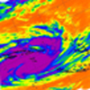
The cold front is still strengthening by the looks of the satellite as it is currently approaching the southwest of the state. The front is expected to move into the southwest tonight, then move over central parts during the morning and to the east during Friday afternoon. EC, ACCESS and UKMET are all in agreement that a cut-off will form just to the east of Melbourne as well during Friday, which will only enhance rain areas and totals. Expect a massive interaction between the moisture availability and the cold front.
Already showers and thunderstorms are forming across the northwest of Victoria and eastern South Australia ahead of the system as the atmosphere continues to destabilize, and this activity should continue tonight, spreading into Victoria, before tending to areas of rain from the west overnight with some locally heavy falls.
Rain areas across most areas of the state tomorrow, but will slowly contract eastwards to have cleared southwest Victoria by midday. Locally heavy falls are again expected, particularly in the northeast, but also over some southern parts of the central regions and near the Otways area thanks to the low. Flooding will again become a concern after the past few months heavy rains, and flood warnings are out for this in the other thread. Showers and isolated thunderstorms are likely on Friday also following the cold front. Local hail is expected in shower and thunderstorm activity. Snow still looks likely down to at least 500m, but even lower values such as 400m are reasonable and flurries are possible even lower. Winds will shift to the southwest and be strong to gale force during the day behind the front, particularly for the southern regions and coastal parts.
Expect some good rainfall across the state. Lots of big falls expected for most of the state, but particularly the northeast where 100mm+ totals are possible. Most of the other parts of the state should see a general 25mm, locally higher up to 50mm in areas that the rain areas focus through.
Jake - Senior AWF Forecaster
Feel free to send me a private message if you have any questions.
Twister wrote:BANG thunderstorms are now exploding with convection now going up all over the shop, looks great out and radar showing some very heavy cells this is getting exciting no sleep for me by the looks of it
Lots to Come storms going up across E Sa W NSw and soon NW Vic
Well, all I need is a few showers here overnight Friday into Saturday and I will have a cover.
I'm seriously not expecting much in the way of precipitation with the coldest air but I reckon there is a fair chance for at least something. 2-3mm usually produces a half decent cover on the ground so hoping for at least that. Dandenongs will probably be completely snowbound.
johnno wrote:Yeah this is big. EC onboard with ACCESS and UKMET with a deep low developing in the trough just East of Melbourne tomorrow morning. Its amazing with models how the dance around and now have come to this conlcusion on the eve of the event.
Looks like EC tonight has gone back to what it had 5 days ago Sunday! For tomorrow system! Cept its now deeper the low and cold air is deeper behind it amazing to watch the models usually come back to what they had 5 days ago EC in particular does it alot. Was always going to develop a deep low this system to much cold air and moisture to play around with to have not too.
That is an excellent post with great effort behind it to demonstrate your intent Johno - thanks.
Naturally I'm hoping the dance will continue with the low forming in NSW and tracking SE down over Merimbula (greedy arent I).
Low likely to slide offshore the W Gippsland coast and give the C areas a whack!
Storms building into NW further over the last hour. Plenty of thundery rain building back through E SA moving SSE and that is what will be here with us in the next 6hrs.
I expect a noisy morning in Melbourne.
Looking good for around 50mm tomorrow perhaps more if storms develop.
Karl Lijnders wrote:Low likely to slide offshore the W Gippsland coast and give the C areas a whack!
Storms building into NW further over the last hour. Plenty of thundery rain building back through E SA moving SSE and that is what will be here with us in the next 6hrs.
I expect a noisy morning in Melbourne.
Looking good for around 50mm tomorrow perhaps more if storms develop.
Ay Karl, what are the chances for thunderstorms to develop tomorrow morning? and what specific time do you predict the main band will hit Melbourne?
Last edited by Harley34 on Thu Oct 14, 2010 7:59 pm, edited 1 time in total.
WOW what an intense little thunderstorm to Milduras west, now south, the structure around 7pm was real impressive nice bow with lots of scud fingers on the N side and some of the heaviest rain i have seen since chasing in the USA almost could not see the white lines with whole areas of road under water was unreal all this under THICK high cloud if only it was sunny today WOW.
Also lots of embedded lightening but some sweet crawlers on the back edge, SO nice to get back out there
More cells going up to my W and E nothing yet to NW and sky dont look great though does look good to N NE E storm to South is still flashing away also storm E of Renmark looks good to.
Cloud band in SA now screaming east hope it slows a bit and tilts later tonight to feed all those rain and thunderstorms down into VIc
Very unstable skies out there stuff will go up all night
Harley, storms are more than likely during the early hours of tomorrow morning. Keep an eye on the Mildura radar and DEan (Twisters) updates.
If you afford to, go to sleep now and then wake up at midnight
Also worth mentioning that lightning tracker detected cells further south in SA nearer to Bordertown.
Sniper wrote:Harley, storms are more than likely during the early hours of tomorrow morning. Keep an eye on the Mildura radar and DEan (Twisters) updates.
If you afford to, go to sleep now and then wake up at midnight
Also worth mentioning that lightning tracker detected cells further south in SA nearer to Bordertown.
Cheers Snipes! Might jst do that. I will probably get up, as things are looking pretty good already.
Question, how are these storms going to form without heating, or is there more to it? Perhaps it's the cold front mmm not sure, can you feel me in?
Storms dont always need heat and sun if you have steep lapse rates different in temp from surface to upper levels this allows air to rise, and if steep then will rise quickly nd Many other factors then you can get storms any time. we have Humid air been up lifted by a strong trigger into cold upper air that is an over simple example though
Most mods have up rain just a tad more so looking good for 15-25mm for W NW, and 25-50mm E of Swan hill, Colac AGAIN and yup to 60-100mm in NE
Mid level cloud really increasing out side and coming from almost due N with NE winds and models now look to push rain down from NSW ahead of the band of rain in SA so wet times ahead wish this was happening during the day so i could enjoy oh well.
They are subtly moving south as well. I must say it is looking like C areas will score well with the whole band likely to tilt as the low builds and develops over the region before bombing to our east. This will see rainfall and storms stall.
Looking vicious and I have not been this excited about event since about Feb 2005.
Yeah you guys are looking good once again man what a month you have had.
Also off note to all, last few frames of the sat pic show the frontal cloud band starting to tilt just of the coast of SA, if this the case and a low forms much further W then tracks across Vic just makes things more interesting
All this while i bake bread from 3am till 1pm which by then all be over here not fair lol.
Looks like Showers to my N NE quickly turning to a big area of rain which will move down into the Swan hill and then later central and Ne areas has really developed last 30 mins
Wow its moist to, Dps in the 15-19c range across NW Vic and W Central NSW no wonder this band will explode
rain pouring across NW NSW and that is all feeding S SE up to 15mm up there should see an easy 50mm there tonight
Karl Lijnders wrote: Looking vicious and I have not been this excited about event since about Feb 2005.
Funny you mention that Karl! Was reading up on that event just yesterday and wondering if this one will dump a similar amount but over a shorter period. Feb 2005 was one heck of a system!
Will probably be too excited to sleep tonight (No smiley for "excited as a 5 year old on Christmas morning" )
Looking like an excellent system, lucky for me I am home tomorrow to see this happen . Car club guys are off to Bendigo tomorrow and were not exactly happy to hear about the weather tomorrow and sat morning!. I was going to trundle up Friday but will wait until mid sat arvo to go meet them now with this system on the way.
Whats the prognosis from then models for snow in my area? We are at 570m so I assume we have a good chance provided everything hits the ranges OK.
I encourage everyone to get rest now and get up early to enjoy. Worst case scenario is that you wake up and there is just rain and not much but atleast you have the option of going to bed!!
Storms really firing now along the band in SE SA inline with the WImmera, Horsham in particular and then over the Grampians into W Central areas.
Storms also continuing in the NW of the state.
Feb 2005 is a standout and this system will not dump as much and as widespread but there will be a fall up to 100mm in the NE and I feel an accumulation of 100mm is likely in E Central areas.
Snow showers I like Going to be a great weekend anyway, though with that much rain coming whats he chances of more flooding? We are off up Bendigo, Castlemaine, Echuca way
James the activity is likely to beinto the Melbourne area as follows:
Western and Northern from 2am
Eastern from 3am
Southern and Southeast from 330am.
Thunderstorms are uncertain but certainly heavy rain likely with flash flooding. I am sure if there are storms around that you will be hearing them, if not that, the rainfall.
Wind change not due till about 12pm and showers and hail with thunderstorms not likely till about 3pm increasing towards evening.
Flooding is a moderate risk over much of the state which experienced flooding in September but will be lower than the recorded levels from last month though it leaves us vulnerable next week with further activity moving south.