Another version of EC for those who are interested...
http://www.coaps.fsu.edu/~maue/tropical ... winds.html" onclick="window.open(this.href);return false;

Welcome New Members! We want to hear from you. Register, stop lurking and start posting!
Victoria: A humid thundery week - 13th-20th Feb 2011
- Twister
- Cumulonumbus Calvas
- Reactions:
- Posts: 914
- Joined: Sun Nov 29, 2009 10:47 pm
- Location: Brisbane Qld
Re: Another humid showery week: 13-20 Feb
Yeah amazing storms in E SA and NW Vic today they formed near Broken Hill around 8am and just propagated S, SW almost all the way to Adel and Mt Gambier unreal just outflow new storm then another outflow then more storms and so on
Few 30-50mm falls under the big cores so quite wet again for many up that way
Looking more widespread tomorrow but dont think they will be as strong
Still not sure about Fri Sat Ec looking great others all over the place shall be interesting
Also lots going on, TC near Darwin, WA another big low, storms in every state bar Tassie lots of rain about
Showers storms next 2 days then some heavy rain about think flooding wont be issue apart from any big storms.
The cut low dont look like going ahead now which is good news for many but i would have liked it
Enjoying the warm humid weather
Now Living in Wet QLD
- droughtbreaker
- Supercell
- Reactions:
- Posts: 2844
- Joined: Wed Nov 25, 2009 7:50 pm
- Location: Mount Macedon, VIC, 520m asl
Re:
Already a handful of trees with significant autumn colour here. I put it down to stress from repeated water logging over summer that has got to some of the trees, especially recently planted or otherwise young trees. The trees that weren't affected by the water logging (probably about 95%) are in great shape atm.hillybilly wrote:Yeah your right Johnno - got the years mixed up. Was a shocker for the gardens as plants went into autumn mode and were then scorched by the heat.
It hasn't really been cool enough to bring on Autumn colour naturally. In 2008, the end of Feb had heaps of days in the high teens here if I remember correctly before that insane March heatwave. We had about 20% of leaves on trees changing colour in late Feb which was ridiculous, then it all stopped dead thanks to the heatwave.
Anyway, this sequence doesn't excite me but I'm sure we'll end up with something by the end of it.
-
Karl Lijnders

- Tornadic Supercell
- Reactions:
- Posts: 5771
- Joined: Sun Nov 22, 2009 11:17 pm
- Location: Knoxfield, Victoria
Re: Another humid showery week: 13-20 Feb
Yeah some of the crab apples are turning they're toes up here after nearly 450mm for Summer!!
It is appearing that the trough is beginning to move into W VIC in an organised fashion. This means scattered showers and thunderstorms to develop from late tomorrow morning over the western and northern plains before spreading into C areas during the mid afternoon. Could well be some hefty totals of 50mm locally with any of the storms.
A repeat performance as the trough stalls through C areas overnight tomorrow where the rain areas will ease. Then scattered showers and thunderstorms developing from late morning Thursday over C districts before spreading east and north as a southerly wind change penetrates the southern half of the state. Another opportunity for local falls creeping towards the 50mm mark but isolated.
Significant rainfall and gusty gale force winds likely on Fri/Sat/Sun with the potential for 50-100mm in areas of W and mountain VIC. Melbourne likely to get 20-40mm if the N wind allows. This will not be a storm event on the Saturday but leading into the areas of rain, western VIC could explode later Friday.
Former Owner - The Australian Weather Forum. Email me anytime - weatherman1000@hotmail.com
Re: Another humid showery week: 13-20 Feb
Karl, will Portland see much in the way of Storms and Rainfall
- norwester
- Cumulonimbus
- Reactions:
- Posts: 105
- Joined: Sat Feb 05, 2011 9:54 am
- Location: Merbein, Vic
Re: Victoria: A humid thundery week - 13th-20th Feb 2011
Just had a short sharp heavy rainfall here in Merbein - 3ml.
Dry, dusty and hot - usually!
- Twister
- Cumulonumbus Calvas
- Reactions:
- Posts: 914
- Joined: Sun Nov 29, 2009 10:47 pm
- Location: Brisbane Qld
Re: Victoria: A humid thundery week - 13th-20th Feb 2011
Looks like another heavy cell about to hit you norwester.
Man the last 6 months in Mildura have been nuts, after living there almost all my life now in Melb I have missed the 2 biggest events in Mildura's history but 2 weeks ago was unreal and it just keeps raining up there crazy.
Showers still firing up in NW Vic but quite every were else
Man the last 6 months in Mildura have been nuts, after living there almost all my life now in Melb I have missed the 2 biggest events in Mildura's history but 2 weeks ago was unreal and it just keeps raining up there crazy.
Showers still firing up in NW Vic but quite every were else
Now Living in Wet QLD
- norwester
- Cumulonimbus
- Reactions:
- Posts: 105
- Joined: Sat Feb 05, 2011 9:54 am
- Location: Merbein, Vic
Re: Victoria: A humid thundery week - 13th-20th Feb 2011
Spot on another 3ml (sounds and feels like much more) in half an hour - woke me up. Still bucketing down! Nothing in the airports rain gauge so far!
Dry, dusty and hot - usually!
- Jake Smethurst
- Supercell
- Reactions:
- Posts: 3583
- Joined: Mon Nov 23, 2009 8:49 pm
- Location: Cheltenham
Re: Victoria: A humid thundery week - 13th-20th Feb 2011
Looking very unstable outside. I think today might be the day for down here.
Otherwise looking like scattered showers and thunderstorms over most of the state, particularly west and central parts. Going to be interesting. I will not be home until later tonight, so no internet until then.
Otherwise looking like scattered showers and thunderstorms over most of the state, particularly west and central parts. Going to be interesting. I will not be home until later tonight, so no internet until then.
Jake - Senior AWF Forecaster
Feel free to send me a private message if you have any questions.
Feel free to send me a private message if you have any questions.
-
Karl Lijnders
- Tornadic Supercell
- Reactions:
- Posts: 5771
- Joined: Sun Nov 22, 2009 11:17 pm
- Location: Knoxfield, Victoria
Re: Victoria: A humid thundery week - 13th-20th Feb 2011
This week's event has become more hit and miss and pot luck so not the widespread heavy falls IMO and we may have dodged a bullet for now with the following TC moisture next week.
In the meantime, local falls of 30-50mm with any mature storm today across the state so some areas will be swamped while others down the road, just mildly wet.
Looking for a few storms around Melbourne from after 1pm.
In the meantime, local falls of 30-50mm with any mature storm today across the state so some areas will be swamped while others down the road, just mildly wet.
Looking for a few storms around Melbourne from after 1pm.
Former Owner - The Australian Weather Forum. Email me anytime - weatherman1000@hotmail.com
- norwester
- Cumulonimbus
- Reactions:
- Posts: 105
- Joined: Sat Feb 05, 2011 9:54 am
- Location: Merbein, Vic
Re: Victoria: A humid thundery week - 13th-20th Feb 2011
Total of 9ml last night here. funny how anytime in the last few years we would have been crowing at that amount, now it seems piddly! Needs to hold of now though for the rest of harvest please.
Dry, dusty and hot - usually!
- firestorm
- Cumulonimbus
- Reactions:
- Posts: 239
- Joined: Wed Dec 02, 2009 9:57 am
- Location: Aireys Inlet
Re: Victoria: A humid thundery week - 13th-20th Feb 2011
very convective unstable sky this morning hopefuly showing a sign of things to come this arvo time will tell i supose 
-
Karl Lijnders
- Tornadic Supercell
- Reactions:
- Posts: 5771
- Joined: Sun Nov 22, 2009 11:17 pm
- Location: Knoxfield, Victoria
Re: Victoria: A humid thundery week - 13th-20th Feb 2011
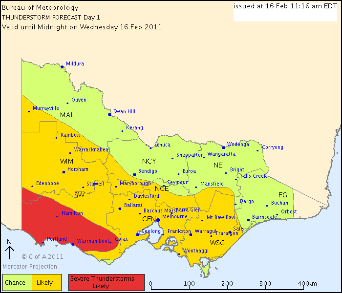
IDV65758
Australian Government Bureau of Meteorology
Victoria Regional Office
THUNDERSTORM FORECAST
Issued at 11:16 am Wednesday, 16 February 2011,
Valid until midnight on Wednesday, 16 February 2011.
Thunderstorms should develop from early afternoon in the likely and severe likely areas. Seabreezes converging with moist northeasterlies make the far southwest the most likely area to experience severe thunderstorms. Flash flooding is the most likely phenomena. Storms will be particularly slow moving. It is not clear that the greater Melbourne area will experience seabreezes but if they occur this will increase the risk of flash flooding storms.
Former Owner - The Australian Weather Forum. Email me anytime - weatherman1000@hotmail.com
- Lily
- Supercell
- Reactions:
- Posts: 4014
- Joined: Wed Nov 25, 2009 10:29 pm
- Location: Rowville/Lysterfield
Re: Victoria: A humid thundery week - 13th-20th Feb 2011
Cell's just firing up on radar over Nojee to the east

Re: Victoria: A humid thundery week - 13th-20th Feb 2011
All the instability is in the SW. Be surprised if the "chance" area gets anything other than a shower or two.
- Lily
- Supercell
- Reactions:
- Posts: 4014
- Joined: Wed Nov 25, 2009 10:29 pm
- Location: Rowville/Lysterfield
Re: Victoria: A humid thundery week - 13th-20th Feb 2011
Radar's starting to look much more interesting to the NE and E of Melbourne now, lots of spots of activity starting to show themselves
- Hamlan
- Storm Chaser
- Reactions:
- Posts: 449
- Joined: Tue Dec 22, 2009 11:05 pm
- Location: Northern suburbs
Re: Victoria: A humid thundery week - 13th-20th Feb 2011
Cells to the NNE now heading towards Melb from Seymour direction as Lily has pointed out. A lone bolt has registered on the WZ lightning tracker down to the SW.
- Storm2
- Cumulus
- Reactions:
- Posts: 66
- Joined: Fri Sep 03, 2010 9:32 pm
- Location: Gippsland= Latrobe Valley - Newborough
Re: Victoria: A humid thundery week - 13th-20th Feb 2011
Starting to get a few rumbles from the cell near noojee. Its all about to happen just as i have to go to work 
- Lily
- Supercell
- Reactions:
- Posts: 4014
- Joined: Wed Nov 25, 2009 10:29 pm
- Location: Rowville/Lysterfield
Re: Victoria: A humid thundery week - 13th-20th Feb 2011
Oh that's a bummer, Storm2, always the way  Now the SW is having it's turn, go Jake! Watching the 128km is a bit like watching popcorn, they're popping up everywhere!
- Harley34
- Cumulonumbus Calvas
- Reactions:
- Posts: 580
- Joined: Sat Mar 06, 2010 1:08 pm
- Location: Ringwood East, Melbourne
Re: Victoria: A humid thundery week - 13th-20th Feb 2011
TOP PRIORITY FOR IMMEDIATE BROADCAST
SEVERE THUNDERSTORM WARNING
for FLASH FLOODING and LARGE HAILSTONES
For people in the Central, South West, North Central, West and South Gippsland and parts of the North East and Wimmera s.
Issued at 1:39 pm Wednesday, 16 February 2011.
Severe thunderstorms are likely to produce very heavy rainfall, flash flooding and large hailstones in the warning area over the next several hours. Locations which may be affected include Warrnambool, Ballarat, Maryborough, Geelong, Melbourne and Traralgon.
Severe thunderstorms have developed near Casterton and other storms are growing near Colac and also in the Latrobe Valley. Storms will keep developing randomly throughout the warning area this afternoon and will be very slow moving. Only the largest storms have the potential to produce damaging hail stones but all will cause flash flooding.
Sun is on and off here, but it's feeling unstable and the sky to the NE is starting to get interesting. 27.5/17.5/55