Bump.....
Just out of interest, the 28 day forecast has the mallee in with a high chance of rain from the 22nd to the 27th. What's the source of this? hope it comes off!

Welcome New Members! We want to hear from you. Register, stop lurking and start posting!
Looking towards substantial rainfall for SE Australia
Re: Looking towards substantial rainfall for SE Australia
The day by day breakdown from CFS (climate model) suggests a front moving through around that time with some extra moisture feeding into it from troughing or a low off NSW. However, trying to forecast individual weather systems such as fronts (instead of average conditions) for such a small area beyond around 2 weeks is just about impossible so I wouldn't bet any money on it yet. We'll just have to wait and see.
EC is currently only painting a very weak wet signal (only 60 to 70% of its members have been shifted into the higher than normal precip regime) over a small part of Vic during this time window which indicates the very high uncertainty.
EC is currently only painting a very weak wet signal (only 60 to 70% of its members have been shifted into the higher than normal precip regime) over a small part of Vic during this time window which indicates the very high uncertainty.
-
Petros

- Supercell
- Reactions:
- Posts: 2001
- Joined: Tue Dec 01, 2009 6:25 pm
- Location: Maffra, Gippsland, Vic
Re: Looking towards substantial rainfall for SE Australia
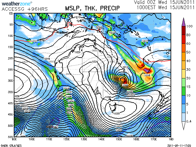
... and in the meantime we have this to contemplate...
-
Supercellimpact

- Supercell
- Reactions:
- Posts: 1238
- Joined: Thu Oct 07, 2010 8:39 pm
- Location: Bendigo
Re: Looking towards substantial rainfall for SE Australia
Blue line right up into NSW for next week, will change no doubt but worth a look at.

-
crikey

- Supercell
- Reactions:
- Posts: 1314
- Joined: Mon Feb 07, 2011 8:02 pm
- Location: tweed shire NSW and nDUNOLLY.. Nth Central district VIC
- Contact:
Re: Looking towards substantial rainfall for SE Australia
Hi supercellimpact. 
In Dunolly we have only had 7mm for June . This coming front is progged for just a few mm for us and the one you post only a few mm for the west.
Wondering if we will get our average rain for June . I have already ordered a water delivery for our water tank. $50 for 4,500litres.including delivery , Will last us a month for 4 people.With my daughter and her defacto staying for awhile , l need all the precipitation we can get. Getting a few buckets of water each morning from the ice dethawing on the roof. That scenario you posted looks like another snow event l suppose.
Wonder what the prognosis is like re snow falls at lower altitudes for June 21?
Haven't the frosts been dramatic. This morning was probably one of the stronger frosts l have seen . Just looked like winter wonderland. I love it!! Winter that is..
Harkup' the outdoor fire at 7.30am and sit by the fire in the fog and frost and just enjoy with a hot cup of tea. Still and beautiful.! An extreme sport this weather watching.
I'd rather do that than photo tornadoes anytime
-
Supercellimpact
- Supercell
- Reactions:
- Posts: 1238
- Joined: Thu Oct 07, 2010 8:39 pm
- Location: Bendigo
Re: Looking towards substantial rainfall for SE Australia
Hey Crikey 
Yeah it's dryed up heaps, it looks unlikely that we will get our average which will make 2 months in a row below average. Synoptic wise we need the high pressure systems to move north more to the usual winter pattern to allow regular cold fronts to penetrate further north from the southern ocean. Fridays front as you said 1-3mm up here and Tuesdays front isn't much either 2-5mm, snow wise, there will be about 5-15cm with the next 2 fronts because the temps will be a tad warm. Tonight is cold already will be a heavy frost no doubt.
Yeah it's dryed up heaps, it looks unlikely that we will get our average which will make 2 months in a row below average. Synoptic wise we need the high pressure systems to move north more to the usual winter pattern to allow regular cold fronts to penetrate further north from the southern ocean. Fridays front as you said 1-3mm up here and Tuesdays front isn't much either 2-5mm, snow wise, there will be about 5-15cm with the next 2 fronts because the temps will be a tad warm. Tonight is cold already will be a heavy frost no doubt.
Re: Looking towards substantial rainfall for SE Australia
It's been looking like the strong winds will be more a feature of the upcoming next couple or so fronts rather than any widespread heavy rain.
-
Karl Lijnders

- Tornadic Supercell
- Reactions:
- Posts: 5771
- Joined: Sun Nov 22, 2009 11:17 pm
- Location: Knoxfield, Victoria
Re: Looking towards substantial rainfall for SE Australia
Indications of southern and mountain areas getting lots of rainfall towards the back end of the long wave feature in around 7 days time. The winds are also too westerly rather than onshore SSW.
I still think SW and NE VIC will do well and widespread damaging winds are possible through this period.
I still think SW and NE VIC will do well and widespread damaging winds are possible through this period.
Former Owner - The Australian Weather Forum. Email me anytime - weatherman1000@hotmail.com
-
Anthony Violi

- Supercell
- Reactions:
- Posts: 2652
- Joined: Mon Nov 23, 2009 9:03 pm
- Location: Lilydale
- Contact:
Re: Looking towards substantial rainfall for SE Australia
Just a quick update on current conditions, this has been the pattern all year. Notice the intense heatwave conditions that are non existent.


Now i posted a lot in the climate section a couple of years ago that our weather was turning, now scientists have raised the possibility of a little ice age returning, which would be continuing the 12 years of cooling we have had.
http://www.theregister.co.uk/2011/06/14/ice_age/" onclick="window.open(this.href);return false;
So if we have a repeat of the Maunder Minimum, there will be widespread and many deaths, and everyone should be worried.
http://www.therealworldweatherforum.com" onclick="window.open(this.href);return false;
avweatherforecasts.com
avweatherforecasts.com
Re: Looking towards substantial rainfall for SE Australia
Anthony, the actual NSO article on which that's based, specifically says:
"We are NOT predicting a mini-ice age. We are predicting the behavior of the solar cycle. In my opinion, it is a huge leap from that to an abrupt global cooling, since the connections between solar activity and climate are still very poorly understood. My understanding is that current calculations suggest only a 0.3 degree C decrease from a Maunder-like minimum, too small for an ice age. It is unfortunate that the global warming/cooling studies have become so politically polarizing."
It's yet another example of a sensationalist website on an anti-global warming crusade, after oversimplistic attention-grabbing garbage "sound bytes" by seizing on such articles, putting words in people's mouths and misquoting them. I also distinctly remember a film made by someone on a similar crusade that proported to prove a 100% correlation between sunspots and global cooling. They based their claims on research done by a body of European solar physicists. It was later revealed they conveniently neglected to show a sizeable chunk of the 20th century where the correlation fell apart and actually reversed. After learning of these claims, those European scientists came out and said how disappointed and angry they were for their research being taken out of context (their research involved investigating solar sunspot cycles - not to prove a watertight correlation between sunspots and global warming/cooling). But you won't hear anything about that on such websites.
It's also worth remembering that of the 5 historically cold autumns between 1917 and the present day, every single one has occurred during or immediately after a La Nina. Of course, there's other factors involved too, but they tend to be a major influence as far as cooler temperatures go.
Back on topic, will be a bit interesting to see what actual rainfall amounts will be over the alpine area in NE VIC over the next several days given the traditional orographic enhancement in that area.
-
Anthony Violi
- Supercell
- Reactions:
- Posts: 2652
- Joined: Mon Nov 23, 2009 9:03 pm
- Location: Lilydale
- Contact:
Re: Looking towards substantial rainfall for SE Australia
I think we will continue to see substantial rainfall for the next 40 years.
It was what i was forecasting, and will continue to forecast. And El Ninos will be less frequent, resulting in a very wet few decades for Australia. We will have a large problem with too much water, both from rainfall and snow fall.
It was what i was forecasting, and will continue to forecast. And El Ninos will be less frequent, resulting in a very wet few decades for Australia. We will have a large problem with too much water, both from rainfall and snow fall.
http://www.therealworldweatherforum.com" onclick="window.open(this.href);return false;
avweatherforecasts.com
avweatherforecasts.com
Re: Looking towards substantial rainfall for SE Australia
I'm pretty sure most people will be wishing for that, regardless of whether or not it's likely. Will be interesting to see if the IPO does end up going into a true negative phase over the next 10 to 30 years and any subsequent effects on modulating rainfall over SE Australia, or whether what we've seen in the past couple or so years is just a random dip.
-
Anthony Violi
- Supercell
- Reactions:
- Posts: 2652
- Joined: Mon Nov 23, 2009 9:03 pm
- Location: Lilydale
- Contact:
Re: Looking towards substantial rainfall for SE Australia
The trend is wetter and cooler, has been for a while now. I like what im seeing from the weather, i dont really look at model predictions.
What im not seeing is the alarmism that it would be getting hotter and drier, its the opposite. And in the next few months we will again see vicious weather in SE OZ with extraordinary rain events. An Auckland style tornado is a near certainty.
What im not seeing is the alarmism that it would be getting hotter and drier, its the opposite. And in the next few months we will again see vicious weather in SE OZ with extraordinary rain events. An Auckland style tornado is a near certainty.
http://www.therealworldweatherforum.com" onclick="window.open(this.href);return false;
avweatherforecasts.com
avweatherforecasts.com
Re: Looking towards substantial rainfall for SE Australia
Another relevant point is that tornadoes aren't uncommon in New Zealand. NZ is actually in the top several regions of the world for tornado frequency. But since the actual real-life odds of a tornado striking a particular point aren't that high in the general scheme of things even in tornado prone areas, all the footage and media attention after a tornado hits a large town or city like Auckland, gives the impression that it's some ominous sign of things to come. Much like how downtown Chicago, Dallas, New York City, Washington DC, etc have rarely seen big tornadoes that have caused widespread damage, even though they lie in a tornado-prone region of the world.
Other points: 'cooler and wetter' for Australia since last year is not representative of long term global changes. There's a whole world outside just Australia. Quite a lot of people have hyped up where it's been cold and wet but conveniently (and always) never mention anything to do with warmth or lack of rain (e.g. the record breaking hot summers across large parts of the northern hemisphere in recent years, NE Canada/Iceland/Greenland, persistent drought in southwest Australia, etc). It's like going to Perth for a day in winter, experiencing a cold wet day and concluding that's going to be representative of what the world will be like throughout every year in the future.
As for wetter conditions, it's been mentioned many times that one of the most fundamental findings from climate change research everywhere is more frequent individual extreme precipitation events and an increase in the average global precipitation. What's still an ongoing area of research is narrowing down more preciesly, exactly which subregions will get drier overall (if the periods between single extreme rain events become drier), which regions will get wetter, and which seasons will be wetter or drier. The continued overall drying trend of southwest Australia and some far southern parts of the continent looks very likely, but I personally like to keep a more open mind about rainfall for SE Oz, especially northern areas of SE Oz and eastern Australia in general. Many would probably disagree with me on that last point though.
Re: Looking towards substantial rainfall for SE Australia
BTW on the subject of viscious weather, one thing worth keeping an eye on is a healthy supply of severe thunderstorms for the SE QLD/NE NSW region during the coming spring/summer if ENSO conditions stay close to neutral through this time. This is due to the correlation between neutral ENSO phases and severe thunderstorms in this region during spring and early summer. Factors like shear, instability and synoptic systems will have to line up well enough for this to happen though so not a guarantee yet.
-
Petros
- Supercell
- Reactions:
- Posts: 2001
- Joined: Tue Dec 01, 2009 6:25 pm
- Location: Maffra, Gippsland, Vic
Re: Looking towards substantial rainfall for SE Australia
Jeez, cant see anything for SE Aus for the next 7-10 days imo. Hopefully the snow resorts get enough frosty nights to continue with the man-made stuff!
Re: Looking towards substantial rainfall for SE Australia
EC looks relentless, showery cold and nasty for the next week or so as the high near Perth is in no hurry to move which has been the common theme most of the Year
-
Petros
- Supercell
- Reactions:
- Posts: 2001
- Joined: Tue Dec 01, 2009 6:25 pm
- Location: Maffra, Gippsland, Vic
Re: Looking towards substantial rainfall for SE Australia
Yep, cold windy and showery, for next week, hopefully good for the snow fields.
Substantial rainfall event for SE Aus? - nup - and nothing significant on the 8-10 horizon either by GFS/AccG
Substantial rainfall event for SE Aus? - nup - and nothing significant on the 8-10 horizon either by GFS/AccG
Re: Looking towards substantial rainfall for SE Australia
The only exception so far has been the past few weeks since late autumn during which the higher pressures have relaxed a bit and allowed some longwave troughing and frontal activity to bring some useful falls and severe weather to coastal southwest WA. Below is the mean MSLP analysis for the latter half of last month showing the higher pressures have been shifted a bit further east over the Bight rather than southwest WA.johnno » Thu Jun 30, 2011 6:08 pm wrote:johnno wrote:EC looks relentless, showery cold and nasty for the next week or so as the high near Perth is in no hurry to move which has been the common theme most of the Year
P.S. the EC's ensemble currently suggests a signal for high pressures around SE Australia approaching mid-month (around the 10th-17th this month) after the upcoming frontal activity and prolonged WSW'ly flow gives way.

-
Karl Lijnders
- Tornadic Supercell
- Reactions:
- Posts: 5771
- Joined: Sun Nov 22, 2009 11:17 pm
- Location: Knoxfield, Victoria
Re: Looking towards substantial rainfall for SE Australia
Interesting signs on GFS for a large rain event offshore the NW WA coastline!! Hmmmmm
Former Owner - The Australian Weather Forum. Email me anytime - weatherman1000@hotmail.com