
Welcome New Members! We want to hear from you. Register, stop lurking and start posting!
Looking towards substantial rainfall for SE Australia
- Jake Smethurst
- Supercell
- Reactions:
- Posts: 3583
- Joined: Mon Nov 23, 2009 8:49 pm
- Location: Cheltenham
Re: Looking towards substantial rainfall for SE Australia
Latest EC at the end of it's run still showing some activity. Will have to keep a very close eye on models.
Jake - Senior AWF Forecaster
Feel free to send me a private message if you have any questions.
Feel free to send me a private message if you have any questions.
Re: Looking towards substantial rainfall for SE Australia
ACCESS and EC have still got it this morning and slowly cranking it up already ACCESS has near 100mm through large parts of SE SA and Western parts of Victoria
- Petethemoskeet
- Cumulonimbus
- Reactions:
- Posts: 272
- Joined: Mon Mar 08, 2010 1:06 pm
- Location: Toowoomba
Re: Looking towards substantial rainfall for SE Australia
End of Access run 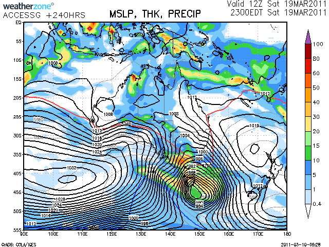
- Lily
- Supercell
- Reactions:
- Posts: 4014
- Joined: Wed Nov 25, 2009 10:29 pm
- Location: Rowville/Lysterfield
Re: Looking towards substantial rainfall for SE Australia
Uh, ok. Now I see it  EC starting to buy into it now too for next Friday and Saturday. There goes the cricket finals
- Jake Smethurst
- Supercell
- Reactions:
- Posts: 3583
- Joined: Mon Nov 23, 2009 8:49 pm
- Location: Cheltenham
Re: Looking towards substantial rainfall for SE Australia
I just find it fascinating how the models can be so different. EC is totally different from GFS from about this Wednesday. Just goes to show the complete uncertainty in the forecasts from then. EC looks the most unstable with thundery weather later next week.
Jake - Senior AWF Forecaster
Feel free to send me a private message if you have any questions.
Feel free to send me a private message if you have any questions.
-
Petros

- Supercell
- Reactions:
- Posts: 2001
- Joined: Tue Dec 01, 2009 6:25 pm
- Location: Maffra, Gippsland, Vic
Re: Looking towards substantial rainfall for SE Australia
So much for the moon closeness thingo theory, no model provides significant rain for SE Aus in the outlook.
-
Karl Lijnders

- Tornadic Supercell
- Reactions:
- Posts: 5771
- Joined: Sun Nov 22, 2009 11:17 pm
- Location: Knoxfield, Victoria
Re: Looking towards substantial rainfall for SE Australia
Your believing models literally a week out. I wonder how our conversations will change over the coming week 
Former Owner - The Australian Weather Forum. Email me anytime - weatherman1000@hotmail.com
-
Didjman

- Supercell
- Reactions:
- Posts: 2100
- Joined: Fri Sep 03, 2010 2:52 pm
- Location: Wallan, Vic 328m ASL
- Contact:
Re: Looking towards substantial rainfall for SE Australia
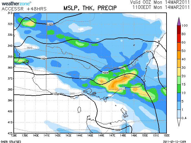
GFS seems to be coming onboard as the following shows:
http://www.weatherzone.com.au/models/?l ... aus&mt=gfs" onclick="window.open(this.href);return false;
So does the Bom 10day forecast:
http://www.weatherzone.com.au/models/" onclick="window.open(this.href);return false; Though it pushes the low through Thurs/Fri.
Still early times though
Peter
http://www.weatherzone.com.au/models/?l ... aus&mt=gfs" onclick="window.open(this.href);return false;
So does the Bom 10day forecast:
http://www.weatherzone.com.au/models/" onclick="window.open(this.href);return false; Though it pushes the low through Thurs/Fri.
Still early times though
Peter
Re: Looking towards substantial rainfall for SE Australia
Yes EC also on it with a cut off in SA and broad upper and surface Trough next Friday to Monday. Its brewing guys.
- droughtbreaker
- Supercell
- Reactions:
- Posts: 2844
- Joined: Wed Nov 25, 2009 7:50 pm
- Location: Mount Macedon, VIC, 520m asl
Re: Looking towards substantial rainfall for SE Australia
Most models I am looking at are indicating a decent system in a week to 10 days time. No reason why it shouldn't happen, big rain events are common in March. There aren't that many rain days but when it does rain at this time of year it is usually tropical origin and often a cut off or easterly trough/dip.
Re: Looking towards substantial rainfall for SE Australia
johnno » Tue Mar 08, 2011 1:00 pm wrote:johnno wrote:Getting inside info (can't reveal my sources) of massive rains hitting SE Australia within the next 2 to 2.5 weeks.. From different sources I have heard all point to the 1 thing.. There was talk earlier in the month of 350mm perhaps falling in NW Victoria this month can't remember who said it?? Since then I have heard 3 NEW different information all pointing to massive rain which believe it or not may eclipse what we had in September and January, If I'm wrong I am perpared to cop egg on my face but given I have heard reports of 8-12 inches in the next 2 weeks or so in some areas near and in Victoria I think 99% of people would be very glad if I am wrong! But I have warned you guys be prepared!
Umm at EC Tonight..
GFS and ACCESS also showing signs of coming onboard
-
Supercellimpact

- Supercell
- Reactions:
- Posts: 1238
- Joined: Thu Oct 07, 2010 8:39 pm
- Location: Bendigo
Re: Looking towards substantial rainfall for SE Australia
About 25mm EC has down from Wednesday onwards. Nothing massive but a good top up.
-
Petros
- Supercell
- Reactions:
- Posts: 2001
- Joined: Tue Dec 01, 2009 6:25 pm
- Location: Maffra, Gippsland, Vic
Re: Looking towards substantial rainfall for SE Australia
Well there is this one looming close by AccR - and they were right for our lucky squirt 2 days ago....
Not supported by other models but naturally I'm hoping.
Not supported by other models but naturally I'm hoping.
-
Petros
- Supercell
- Reactions:
- Posts: 2001
- Joined: Tue Dec 01, 2009 6:25 pm
- Location: Maffra, Gippsland, Vic
Re: Looking towards substantial rainfall for SE Australia
Bugger me AccessR was spot on again in terms of Gippsland rain. Twice in a row and now I'm getting confident that AccessR is as good as the old MLAPS which worked well for Gippsland. How did AccessR perform for other Vic's??? We got >10mm with this change (20mins ago reading) and I'd go out to see the latest if my shirt had dried out after the last dash.! 
[edit] - ended up with 16mm last evening.
[edit] - ended up with 16mm last evening.
Re: Looking towards substantial rainfall for SE Australia
Latest 00z EC is back on for a prolonged period of unsettled wet weather for Victoria and SE Australia from Saturday onwards I would say
- droughtbreaker
- Supercell
- Reactions:
- Posts: 2844
- Joined: Wed Nov 25, 2009 7:50 pm
- Location: Mount Macedon, VIC, 520m asl
Re: Looking towards substantial rainfall for SE Australia
That's a huge system that EC is showing in the latest run. Scattered storms statewide next weekend, then widespread and prolonged heavy rain for a day or two and then a massive wrap around for west central in SE convergent flow and then probably a couple of days of showers and drizzle afterwards. Definitely one to watch.
-
crikey

- Supercell
- Reactions:
- Posts: 1314
- Joined: Mon Feb 07, 2011 8:02 pm
- Location: tweed shire NSW and nDUNOLLY.. Nth Central district VIC
- Contact:
Re: Looking towards substantial rainfall for SE Australia
Hey . I finally figured our what Johnno and anthonyV and others are talking about regarding lots of rain in a week or two.
That low in NWest WA near the coast is undergoing cyclogenesis and the easterlies are likely to push it out to sea where it can feed and grow. Then it will migrate south and all its remnants get strewn across the southern cross section of Australia.
This animated satellite pic is showing some convincing clockwise rotation.
http://www.metoffice.gov.uk/satpics/australasia_IR.html" onclick="window.open(this.href);return false;
Press control ++ for a nice close up. This key sequence enlarges the screen
- Lily
- Supercell
- Reactions:
- Posts: 4014
- Joined: Wed Nov 25, 2009 10:29 pm
- Location: Rowville/Lysterfield
Re: Looking towards substantial rainfall for SE Australia
Thank you Crikey!
- Jake Smethurst
- Supercell
- Reactions:
- Posts: 3583
- Joined: Mon Nov 23, 2009 8:49 pm
- Location: Cheltenham
Re: Looking towards substantial rainfall for SE Australia
Yep latest EC showing some very interesting weather from the weekend. Initially thundery then widespread heavy rain. Andrew covers it nicely ... Otways in particular (including me) would do well in this set-up. But its a fair way out, however something is brewing. I'm inclined to go with EC at this stage, despite no similar data on other models for Victoria.
Jake - Senior AWF Forecaster
Feel free to send me a private message if you have any questions.
Feel free to send me a private message if you have any questions.
-
crikey
- Supercell
- Reactions:
- Posts: 1314
- Joined: Mon Feb 07, 2011 8:02 pm
- Location: tweed shire NSW and nDUNOLLY.. Nth Central district VIC
- Contact:
Re: Looking towards substantial rainfall for SE Australia
Re: WA depression
That N/West WA low has rotating arms and it is growing. ( inland). It looks amazing. I am astonished at the speed of development of extensive white upper cloud .
Can't wait to look at the satellite in the morning. Going to take a snapshot now .
Implications. The mind boggles!

That N/West WA low has rotating arms and it is growing. ( inland). It looks amazing. I am astonished at the speed of development of extensive white upper cloud .
Can't wait to look at the satellite in the morning. Going to take a snapshot now .
Implications. The mind boggles!