Was just going for the Calendar year...2011 will be the wettest year. Just saying it now.
And yes the world can feed itself when its wet, but not when it floods over and over and over again. Just like the world can feed itself when the weather is warm, just not when it is consistently hot.
Welcome New Members! We want to hear from you. Register, stop lurking and start posting!
Looking towards substantial rainfall for SE Australia
-
Karl Lijnders

- Tornadic Supercell
- Reactions:
- Posts: 5771
- Joined: Sun Nov 22, 2009 11:17 pm
- Location: Knoxfield, Victoria
Re: Looking towards substantial rainfall for SE Australia
Big call there Petros. Let's hope it is for our water storages.
It does appear the big wet will continue with an enormous rain event beginning in a week from today which has the potential to be as big as what we had back in January across the state. The concern with this system is that it looks to be cradled for a long period of time so rainfall will not be going anywhere and moisture ports from the NE, N and NW are very active at the moment so the weather will funnel down here readily.
I am anticipating on current prognostics, around 100-200mm again for many areas accummulated over a course of days and locally heavy on the ranges.
Time will tell but we will see how we go.
Former Owner - The Australian Weather Forum. Email me anytime - weatherman1000@hotmail.com
-
Anthony Violi

- Supercell
- Reactions:
- Posts: 2652
- Joined: Mon Nov 23, 2009 9:03 pm
- Location: Lilydale
- Contact:
Re: Looking towards substantial rainfall for SE Australia
The status quo remains until Spring this year. Megalitres of rain, floods, damage, another March 6 storm and a Feb 2005 event all coming up.
The winter will be especially wet, and also Perth will break its drought soon and be decimated by floods, tornadoes and the strongest fronts in 20 years.
Even then its up to the Oscillations after Spring but given the winter to we are about to cop, Spring will be savage and we may even see a return to the massive thunderstorms clear air style we failed to se this year due to the increased moisture. Given the outlook for warmer than average SST Sw of Perth through the winter im confident they will get obliterated.
On current events here, as karl says, the next 2 months will see the same, troughs and cut offs cradled and generally flooding half the country. The dnager is now there with the cold air westerly belt already pushing up strong so early, if it hooks up we are gone.
http://www.therealworldweatherforum.com" onclick="window.open(this.href);return false;
avweatherforecasts.com
avweatherforecasts.com
-
Petros

- Supercell
- Reactions:
- Posts: 2005
- Joined: Tue Dec 01, 2009 6:25 pm
- Location: Maffra, Gippsland, Vic
Re: Looking towards substantial rainfall for SE Australia
GFS, ACCESS and EC are all progging a very large easterly dip situation for most of southern Aust late next weekend and into the following week. At the moment the focus is on S SA with huge rain totals over the days that way, Vic should also be looking at 100+ totals as well. A long way, out but all the moisture from Pt Hedland and up into Arneham Land seems to be headed down to southern aust by current model consensus.
-
stratospear

- Supercell
- Reactions:
- Posts: 1261
- Joined: Sat Dec 19, 2009 9:38 am
- Location: Usually Bendigo
Re: Looking towards substantial rainfall for SE Australia
The MJO pulse is heading toward the phases where lots of tropical moisture tend to be available for transporting down here next week.
A lot will depend on a trigger from the SW. If that happens, then it will be "Game On".
A lot will depend on a trigger from the SW. If that happens, then it will be "Game On".
-
Karl Lijnders
- Tornadic Supercell
- Reactions:
- Posts: 5771
- Joined: Sun Nov 22, 2009 11:17 pm
- Location: Knoxfield, Victoria
Re: Looking towards substantial rainfall for SE Australia
I think the fact that the high is cradling the moisture is the trigger for this event, and it will not clear out with a bang, so for me this is the most concerning system that we have been looking at or sequence of synoptics that we have been looking at all summer.
The last few systems have been flushed out with a big climax with dry cold air and that has delivered a mammoth amount of rainfall, but this system is possibly going to sit for quite awhile over the reigon.
The last few systems have been flushed out with a big climax with dry cold air and that has delivered a mammoth amount of rainfall, but this system is possibly going to sit for quite awhile over the reigon.
Former Owner - The Australian Weather Forum. Email me anytime - weatherman1000@hotmail.com
-
Supercellimpact

- Supercell
- Reactions:
- Posts: 1241
- Joined: Thu Oct 07, 2010 8:39 pm
- Location: Bendigo
Re: Looking towards substantial rainfall for SE Australia
A few 100+ falls around

- Microburst
- Cumulus
- Reactions:
- Posts: 32
- Joined: Wed Nov 24, 2010 4:31 pm
- Location: Horsham
Re: Looking towards substantial rainfall for SE Australia
Karl, I am with you on this one. Just have that feeling, also saw a lizard looking skyward on my way home from work, which is usually a sign a big rain is on the way, and he didnt even predict recent downpours. Now given the set of circumstances it could be the biggest yet...
Time will tell.
Time will tell.
-
Karl Lijnders
- Tornadic Supercell
- Reactions:
- Posts: 5771
- Joined: Sun Nov 22, 2009 11:17 pm
- Location: Knoxfield, Victoria
Re: Looking towards substantial rainfall for SE Australia
Hi Microburst.
I can only hope for the states sake that soaking steady rain falls over this period and the heaviest falls reserved for the Melbourne catchments. That would be in my perfect world but at this stage I am a little nervous.
Latest GFS keeps the threat very high next week.
Also watch the pair of lows over the N NT which will also become absorbed into the outflow from TC Carlos over in WA.
Former Owner - The Australian Weather Forum. Email me anytime - weatherman1000@hotmail.com
-
Petros
- Supercell
- Reactions:
- Posts: 2005
- Joined: Tue Dec 01, 2009 6:25 pm
- Location: Maffra, Gippsland, Vic
Re: Looking towards substantial rainfall for SE Australia
Yep, a prolonged easterly dip situation into next week seems to be the go. Thundery wet weather for maybe even 5 days from Sunday on. Big Ted for me.
The Aussie monsoon season next intensification looks to be 10 days or so away though going by the current situation below....
I am I correct?
The Aussie monsoon season next intensification looks to be 10 days or so away though going by the current situation below....
I am I correct?
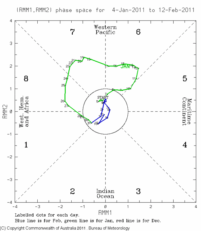
Re: Looking towards substantial rainfall for SE Australia
The current MJO signal is pretty weak (as indicated by its recent trend inside the middle circle). The ensembled versions of various models such as EC, GFS, etc produce MJO forecast diagrams and maps - you can view some of the GFS products here:
http://www.cpc.ncep.noaa.gov/products/p ... egfs.shtml (blue = increased cloudiness trapping in lots of outgoing longwave radiation which implies enhanced convection and an active MJO pulse). Also, for those who weren't aware already, the average effects of the MJO on SE Australia as well as the continent in general for the current season are here:
http://www.bom.gov.au/climate/mjo/graph ... urrent.gif
It's worth remembering though that models often have a hard time trying to nail the MJO accurately compared to other smaller-scale weather systems.
There's also other tropical influences that are regularly monitored because they can increase the likelihood of TC's forming. A couple of examples include Kelvin Waves which travel eastwards across the global tropics and Equatorial Rossby Waves which travel westwards. Like the MJO, they're basically big pulses or waves that propagate through the atmosphere/ocean associated with increased convection and can trigger TC's if other conditions are favourable. Strong SE wind surges pushing up into NW'ly monsoonal flow to their northeast can also impart a spin to the flow and trigger TC's.
Meanwhile, below are the Bureau's weekly tropical notes about the MJO issued last Tuesday (updated every Tue) - they're at
http://www.bom.gov.au/climate/tropnote/tropnote.shtml:
"A very weak MJO lingers
Over the past week, the remnants of a weak Madden-Julian Oscillation (MJO) signature have continued propagating eastwards through the Indian Ocean. Even though the degree of uncertainty remains high, the majority of computer models surveyed by the Bureau are suggesting an MJO pulse may return to the eastern Indian Ocean within the next fortnight; however it is expected to remain weak. Over the last seven days, the enhanced convection observed over northern and eastern Australia was largely due to Ex-tropical Cyclone Yasi. Rainfall and tropical cyclone activity across northern Australia continues to remain at above-normal levels. This can be largely attributed to the strength of the current La Niña and the dominant influence it has had on north Australia’s weather during the current Wet Season. Although a weak MJO is forecast for the next couple of weeks, rainfall and tropical cyclone activity is expected to remain average to above-average across northern Australia, mostly due to the ongoing influence of La Niña."
-
Karl Lijnders
- Tornadic Supercell
- Reactions:
- Posts: 5771
- Joined: Sun Nov 22, 2009 11:17 pm
- Location: Knoxfield, Victoria
Re: Looking towards substantial rainfall for SE Australia
Models have somewhat scaled back the rainfall potential at this point in time, thank goodness, as it was looking severe for a wide area of the state. Still plenty of time for that too change. But to me it looks like we have dodged a bullet.
Still a tonne of moisture coming through the inland of Australia and perhaps further rain down the track.
Still a tonne of moisture coming through the inland of Australia and perhaps further rain down the track.
Former Owner - The Australian Weather Forum. Email me anytime - weatherman1000@hotmail.com
-
Petros
- Supercell
- Reactions:
- Posts: 2005
- Joined: Tue Dec 01, 2009 6:25 pm
- Location: Maffra, Gippsland, Vic
Re: Looking towards substantial rainfall for SE Australia
By this arvo's batch of models, I wouldnt be letting out 25% of Victorians dams waters ahead of rain in the next 6-10 days that for sure.
- Lily
- Supercell
- Reactions:
- Posts: 4014
- Joined: Wed Nov 25, 2009 10:29 pm
- Location: Rowville/Lysterfield
Re: Looking towards substantial rainfall for SE Australia
Off topic, sorry, but 28storms have posted a new youtube video over in the NT Wet Season thread regarding the tropical low forming up there (and over in WA). Worth a watch 
-
Karl Lijnders
- Tornadic Supercell
- Reactions:
- Posts: 5771
- Joined: Sun Nov 22, 2009 11:17 pm
- Location: Knoxfield, Victoria
Re: Looking towards substantial rainfall for SE Australia
Really interested in the rebound of moisture in about 10 days time as we go into a NE/E flow. Appears that a lot of moisture is going to be dragged down into our neck of the woods, however models are now persisting with throwing up upper levels systems, cold air and sharp thermal troughs.
I got a feeling we could be on the verge of a very similar event to March 6th last year.
I got a feeling we could be on the verge of a very similar event to March 6th last year.
Former Owner - The Australian Weather Forum. Email me anytime - weatherman1000@hotmail.com
- Lily
- Supercell
- Reactions:
- Posts: 4014
- Joined: Wed Nov 25, 2009 10:29 pm
- Location: Rowville/Lysterfield
Re: Looking towards substantial rainfall for SE Australia
Yikes! Where can I purchase sandbags from?

-
Petros
- Supercell
- Reactions:
- Posts: 2005
- Joined: Tue Dec 01, 2009 6:25 pm
- Location: Maffra, Gippsland, Vic
Re: Looking towards substantial rainfall for SE Australia
If "feelings" are allowed to be a valid post, then I've got a feeling that La Nina opportunity will bypass SE Vic over the next 8 days.
-
Karl Lijnders
- Tornadic Supercell
- Reactions:
- Posts: 5771
- Joined: Sun Nov 22, 2009 11:17 pm
- Location: Knoxfield, Victoria
Re: Looking towards substantial rainfall for SE Australia
LOL! Your allowed to express instict forecasting here!! How do you think I do it!!?
I must say the first part of the week looks pretty good but increasing humidity later in the week and into the weekend could see a return of showers and storms. Another major rain event in 7-10 days time.
It will be nice to have some summer sunshine!!
I must say the first part of the week looks pretty good but increasing humidity later in the week and into the weekend could see a return of showers and storms. Another major rain event in 7-10 days time.
It will be nice to have some summer sunshine!!
Former Owner - The Australian Weather Forum. Email me anytime - weatherman1000@hotmail.com
- HarleyB
- Cumulonumbus Calvas
- Reactions:
- Posts: 839
- Joined: Sun Oct 10, 2010 9:39 pm
- Location: Wangaratta
Re: Looking towards substantial rainfall for SE Australia
The details are a little sketchy at this point but is there also a chance of a major rain event somewhere around March 5th?
Re: Looking towards substantial rainfall for SE Australia
Is there Harley? Not sure where you got that from mate? Anyway I can't see anything worthwhile for at least minimum of another week, next week should be fine and stable odd coastal shower perhaps on a couple of mornings