
Welcome New Members! We want to hear from you. Register, stop lurking and start posting!
Victoria: Trough/Front - Storms and rain - 17th -19th Nov
- solcampbell
- Cumulus
- Reactions:
- Posts: 58
- Joined: Tue Dec 07, 2010 6:29 pm
- Location: Grovedale, Geelong
Re: Victoria: Trough/Front - Storms and rain - 17th -19th No
Thunder just got a whole lot louder but still nothing else at the moment. Wind has swung to the west and we have dropped from 36.8 at 4pm to 33.8 now.
Re: Victoria: Trough/Front - Storms and rain - 17th -19th No
Looks to hit us right when i leave for work!!
fortius quo fidelius
-
flatcam
- Cumulonimbus
- Reactions:
- Posts: 182
- Joined: Wed Jan 05, 2011 8:16 pm
- Location: Craigieburn, Victoria
Re: Victoria: Trough/Front - Storms and rain - 17th -19th No
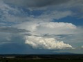
BIG anvil visible over the bay here! 
Should get fun pretty soon considering the line going back to the S.A. border
Cheers, Cam
Should get fun pretty soon considering the line going back to the S.A. border
Cheers, Cam
- Rhino
- Supercell
- Reactions:
- Posts: 1227
- Joined: Mon Nov 30, 2009 11:37 am
- Location: Carisbrook-Near Maryborough
Re: Victoria: Trough/Front - Storms and rain - 17th -19th No
That lines really starting to arc up now, shes gunna blow !!!
Rhino.
Rhino.
- solcampbell
- Cumulus
- Reactions:
- Posts: 58
- Joined: Tue Dec 07, 2010 6:29 pm
- Location: Grovedale, Geelong
Re: Victoria: Trough/Front - Storms and rain - 17th -19th No
Wind now SSE here and down to 24 degrees. Dropped 12.8 degrees in 45 minutes.
- solcampbell
- Cumulus
- Reactions:
- Posts: 58
- Joined: Tue Dec 07, 2010 6:29 pm
- Location: Grovedale, Geelong
Re: Victoria: Trough/Front - Storms and rain - 17th -19th No
now it's bucketing down, lightning, thunder, water tank overflowing cos I didn't clear the mesh earlier. Awesome
Re: Victoria: Trough/Front - Storms and rain - 17th -19th No
Nice toasty 90degrees here atm
Wind gusting between 10-30 k/hr
Looks like the storms will hit just as out to dinner, typical really
Wind gusting between 10-30 k/hr
Looks like the storms will hit just as out to dinner, typical really
-
Anthony Violi

- Supercell
- Reactions:
- Posts: 2652
- Joined: Mon Nov 23, 2009 9:03 pm
- Location: Lilydale
- Contact:
Re: Victoria: Trough/Front - Storms and rain - 17th -19th No
The forecast of about 6mm by Norwegian is going to look really foolish very shortly, at least 25mm through Central and Eastern areas. Haven't been able to work Out all week why models weren't on it, this heat is perfect breeding ground, trough is stalling and moisture aplenty..anyhow enjoy the night, looks very good!
http://www.therealworldweatherforum.com" onclick="window.open(this.href);return false;
avweatherforecasts.com
avweatherforecasts.com
Re: Victoria: Trough/Front - Storms and rain - 17th -19th No
is this likely to persist overnight or is it just this front then all over?
- Bellarine
- Cumulonimbus
- Reactions:
- Posts: 180
- Joined: Thu Dec 31, 2009 8:50 pm
- Location: Box Hill North
Re: Victoria: Trough/Front - Storms and rain - 17th -19th No
Did anyone see what looked like a hook on the rainband radar as that big black cell passed just to the east of Airey's Inlet?
Later peak hour driving is going to be interesting
Later peak hour driving is going to be interesting
Re: Victoria: Trough/Front - Storms and rain - 17th -19th No
Yep its all happening here. Just went and picked my 4 year old boy up from kinder....getting back in the car flash BBBBAAAAANNNG!!! He has just spent the last half hour learning about storms and how it all works...lol.
torrential rain here now. Constant light show and massive thunder as a result. Might turn pc off for a bit now!
oh yeah there were tears too!
torrential rain here now. Constant light show and massive thunder as a result. Might turn pc off for a bit now!
oh yeah there were tears too!
- Twiggy
- Cumulus
- Reactions:
- Posts: 67
- Joined: Wed Nov 09, 2011 6:19 pm
- Location: Loddon Valley, Bears Lagoon.
Re: Victoria: Trough/Front - Storms and rain - 17th -19th No
Can Anyone tell me what it will be like a little North Of Bendigo??
Its looking nasty SW and on radar coming from SA......
Its looking nasty SW and on radar coming from SA......
Re: Victoria: Trough/Front - Storms and rain - 17th -19th No
Well im off to work, heres hoping lightning knocks out the power and we can all go home!!!! Look forward to the reports after!!
fortius quo fidelius
-
Anthony Violi
- Supercell
- Reactions:
- Posts: 2652
- Joined: Mon Nov 23, 2009 9:03 pm
- Location: Lilydale
- Contact:
Re: Victoria: Trough/Front - Storms and rain - 17th -19th No
Trough is stalling, strap your self in, may go until tomorrow night! Will be another great display of lightning.
http://www.therealworldweatherforum.com" onclick="window.open(this.href);return false;
avweatherforecasts.com
avweatherforecasts.com

Re: Victoria: Trough/Front - Storms and rain - 17th -19th No
About to head out. Fingers crossed I see something, the best storms look to be down south tho.
- Jake Smethurst
- Supercell
- Reactions:
- Posts: 3583
- Joined: Mon Nov 23, 2009 8:49 pm
- Location: Cheltenham
Re: Victoria: Trough/Front - Storms and rain - 17th -19th No
That line looks very good on radar, Melbourne about to get some nice thunderstorms. In fact the trough is only in the far southwest currently, and probably will not reach Melbourne until 11pm or after now. Lots of opportunity for further thunderstorm activity to develop behind this line anywhere in the state. This could only be round 1. Will have to watch the radar in coming hours.
EDIT: If you look at this radar,http://www.weatherzone.com.au/radar/vic, it sucks, we are stuck in the middle of two lines!!
EDIT: If you look at this radar,http://www.weatherzone.com.au/radar/vic, it sucks, we are stuck in the middle of two lines!!
Jake - Senior AWF Forecaster
Feel free to send me a private message if you have any questions.
Feel free to send me a private message if you have any questions.
-
typhoon29

- Cumulonumbus Calvas
- Reactions:
- Posts: 510
- Joined: Fri Jan 01, 2010 11:05 pm
- Location: Ballarat (Mitchell Park)
- Contact:
Re: Victoria: Trough/Front - Storms and rain - 17th -19th No
Here in Ballarat the temnp rose like a rocket, it was 21 @ 8am, by midday it was 31! The sky was building all afternoon with prefrontal/trough cells bellowing up, The first band came through right on knock off time 5pm. not much rain, plenty of wind and lightning/thunder. Saw some awesome CGs driving home. The next band should be here by middnight with another stormy rain band. Should turn to more general rain tomorrow as the system stalls. More afternoon storms possible tomorrow too then that will be if for the humid stuff and this system.
Ballarat, Home of the Anti-Thunderstorm Shield!
- solcampbell
- Cumulus
- Reactions:
- Posts: 58
- Joined: Tue Dec 07, 2010 6:29 pm
- Location: Grovedale, Geelong
Re: Victoria: Trough/Front - Storms and rain - 17th -19th No
Clear skies here once again. Amazing how quickly it cleared off.
-
Anthony Violi
- Supercell
- Reactions:
- Posts: 2652
- Joined: Mon Nov 23, 2009 9:03 pm
- Location: Lilydale
- Contact:
Re: Victoria: Trough/Front - Storms and rain - 17th -19th No
It will build again as Jake mentioned Sol, in keeping with the theme of this extraordinary weather, we have about 12 troughs ion the last 2 days lingering around.
Wind change currently moving through Western suburbs, looks very strong too, temps in Geelong now 19 compared with a very warm 33 in the CBDesert.
Wind change currently moving through Western suburbs, looks very strong too, temps in Geelong now 19 compared with a very warm 33 in the CBDesert.
http://www.therealworldweatherforum.com" onclick="window.open(this.href);return false;
avweatherforecasts.com
avweatherforecasts.com
- aussiestormfreak
- Cumulonumbus Calvas
- Reactions:
- Posts: 534
- Joined: Thu Feb 03, 2011 9:52 am
- Location: Melbourne, Corryong, Merimbula, and Fiji
- Contact:
Re: Victoria: Trough/Front - Storms and rain - 17th -19th No
YESSS!!! 35.5C on my thermometer today!!! Another major milestone for me reached as the warm season progresses!
And although the temperature is cooling down (a bit... currently about 31C), the action is heating up!
I was out in Dandenong between 3PM and 4PM, managed to watch and photograph that large cell passing across the southern tip of the Mornington Peninsula, and to a lesser extent the one behind it around Anglesea
On the return trip home, I stopped up along Glenfern Road... and despite the haze, all across the west and south convection is going off like volcanic eruptions with massive cumulonimbus exploding!
Give it about an hour and those cells that are now over the Baccus Marsh/Melton area should reach the Dandenong Ranges. And since the cold front & low pressure trough are still a long way behind as you guys mentioned, after this squall line has gone through we may get more showers & thunderstorms overnight
: