
Welcome New Members! We want to hear from you. Register, stop lurking and start posting!
Victoria: A humid thundery week - 13th-20th Feb 2011
-
Onetahuti

- Supercell
- Reactions:
- Posts: 2791
- Joined: Thu Mar 25, 2010 9:37 pm
- Location: Dandenong Nth.
Re: Victoria: A humid thundery week - 13th-20th Feb 2011
Dean Stewart on ABC 774 saying 15 - 30mm in Melbourne area
Re: Victoria: A humid thundery week - 13th-20th Feb 2011
Well, I'm going out with my camera. Watch the buggers flatten out now 
- Hamlan
- Storm Chaser
- Reactions:
- Posts: 449
- Joined: Tue Dec 22, 2009 11:05 pm
- Location: Northern suburbs
Re: Victoria: A humid thundery week - 13th-20th Feb 2011
Cool! always good to see another chasers spoilsAUS_Twisted » Fri Feb 18, 2011 4:06 pm wrote:AUS_Twisted wrote: Putting together a video of the Mortlake cell with photos also, might have it done in a day or 2 depending when I feel it's done and if theres no more storm action around.
Re: Victoria: A humid thundery week - 13th-20th Feb 2011
Starting to get quite dark to my North, plenty of convection the whole NW - NE sky
-
flatcam
- Cumulonimbus
- Reactions:
- Posts: 182
- Joined: Wed Jan 05, 2011 8:16 pm
- Location: Craigieburn, Victoria
Re: Victoria: A humid thundery week - 13th-20th Feb 2011
That storm is on top of us right now. The rain rate is incredible at times with large drops. It seems to be pulsing between almost no sound, to defening loudness on my carport roof.
Pretty much caused instant minor flooding of the road
Cheers, Cam
EDIT: Got a lovely view of the rain shaft after it had gone through. It's quite serious. If the storm maintains that intensity, it will cause flooding issues in Melbourne I think.
Pretty much caused instant minor flooding of the road
Cheers, Cam
EDIT: Got a lovely view of the rain shaft after it had gone through. It's quite serious. If the storm maintains that intensity, it will cause flooding issues in Melbourne I think.
Last edited by flatcam on Fri Feb 18, 2011 5:37 pm, edited 1 time in total.
-
Petros

- Supercell
- Reactions:
- Posts: 2001
- Joined: Tue Dec 01, 2009 6:25 pm
- Location: Maffra, Gippsland, Vic
Re: Victoria: A humid thundery week - 13th-20th Feb 2011
Easterly drizzle this morning gave us 0.5mm for this thread, remained windy E'ly and overcast all day (still is), 23C max, baro backed off from 1017 to 1014 hPa during the day.
AccessR now gives us 20-30mm from now till tomorrow lunchtime . I'll believe it when I pour it out of the gauge. I reckon 7.5mm may see us out tonight.
............ but would love to be proven wrong.
AccessR now gives us 20-30mm from now till tomorrow lunchtime
............ but would love to be proven wrong.
Re: Victoria: A humid thundery week - 13th-20th Feb 2011
any thunder with that storm?
I'm down in black rock...be nice if something happened by the bay
Edit: looks like its going the wrong way grr
I'm down in black rock...be nice if something happened by the bay
Edit: looks like its going the wrong way grr
-
flatcam
- Cumulonimbus
- Reactions:
- Posts: 182
- Joined: Wed Jan 05, 2011 8:16 pm
- Location: Craigieburn, Victoria
Re: Victoria: A humid thundery week - 13th-20th Feb 2011
Didn't hear any when it went over about 20 minutes ago. The storm appears to have gained strength though since it passed over here. I think the CBD might flood a fair bit with that cell.James » Fri Feb 18, 2011 5:40 pm wrote:James wrote:any thunder with that storm?
I'm down in black rock...be nice if something happened by the bay
Edit: looks like its going the wrong way grr
I managed some pics of the rain shaft before. I'll try and upload when I can.
Cheers, Cam
-
tizza

- Cumulonumbus Calvas
- Reactions:
- Posts: 728
- Joined: Wed Nov 25, 2009 6:48 pm
- Location: Dandenong North
- Contact:
Re: Victoria: A humid thundery week - 13th-20th Feb 2011
VERY LOUD THUNDER!!!!!!!!!!
CAN YOU HEAR ME????
CAN YOU HEAR ME????
- norwester
- Cumulonimbus
- Reactions:
- Posts: 105
- Joined: Sat Feb 05, 2011 9:54 am
- Location: Merbein, Vic
Re: Victoria: A humid thundery week - 13th-20th Feb 2011
Steady rain up here now, started about 10 mins ago, falling a bit more heavily than the mildura radar is showing ( as usual) - 1ml in the gauge. I think i need to pop over to the airport BOM with my pen and colour it in a bit! No wind to speak of though and the temp has dropped a couple of degrees - still humid though.
Dry, dusty and hot - usually!
-
tizza
- Cumulonumbus Calvas
- Reactions:
- Posts: 728
- Joined: Wed Nov 25, 2009 6:48 pm
- Location: Dandenong North
- Contact:
Re: Victoria: A humid thundery week - 13th-20th Feb 2011
I must admit, I think that might have been a bolt out of the blue, the sky doesn't look that bad. I'm sure I'll eat those words in 10 mins, dead calm and extremely oppressive here
-
mick

- Supercell
- Reactions:
- Posts: 1453
- Joined: Mon Nov 30, 2009 6:45 pm
- Location: Mid North SA Baaaaaaaaaaaaaaa
Re: Victoria: A humid thundery week - 13th-20th Feb 2011
Roaring easterly here, being sucked into something.
-
AUS_Twisted

- Storm Chaser
- Reactions:
- Posts: 652
- Joined: Wed Nov 25, 2009 6:15 pm
- Location: Dandenong North, Melb
Re: Victoria: A humid thundery week - 13th-20th Feb 2011
I was going to check out that cell NW of city but cant be bothered with all the peak hour traffic lol, looks pretty good on radar though.
-
tizza
- Cumulonumbus Calvas
- Reactions:
- Posts: 728
- Joined: Wed Nov 25, 2009 6:48 pm
- Location: Dandenong North
- Contact:
Re: Victoria: A humid thundery week - 13th-20th Feb 2011
YEP, so it is floyd!!
I'm sorry to ask but where are you again mate?
I'm basically near corner of Rowena Pde and Punt Rd
No rain here as yet, not a drop, no more thunder either
I'm sorry to ask but where are you again mate?
I'm basically near corner of Rowena Pde and Punt Rd
No rain here as yet, not a drop, no more thunder either
-
flatcam
- Cumulonimbus
- Reactions:
- Posts: 182
- Joined: Wed Jan 05, 2011 8:16 pm
- Location: Craigieburn, Victoria
Re: Victoria: A humid thundery week - 13th-20th Feb 2011
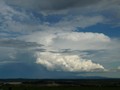
Large anvil visible here. Very dark base too with lots of rain. You guys should get a good show! 
Cheers, Cam
Cheers, Cam
Re: Victoria: A humid thundery week - 13th-20th Feb 2011
whats the weather situation like, are more expected to form...or is it just going to be an area of rain and wind tonight?
-
Didjman

- Supercell
- Reactions:
- Posts: 2100
- Joined: Fri Sep 03, 2010 2:52 pm
- Location: Wallan, Vic 328m ASL
- Contact:
Re: Victoria: A humid thundery week - 13th-20th Feb 2011
Part of a SWW Courtesy of the BoM:
"A low pressure system is expected to form over South Australia today and will deepen and move southeastwards tonight before heading southeast during Saturday.
Damaging winds averaging 60 to 70 km/h with peak gusts around 100 km/h are forecast to develop over parts of the South West, North Central, Central and North East forecast districts overnight. Elevated areas are most susceptible.
Rain and thunderstorms which may lead to flash flooding is forecast to develop from the west later tonight, reaching eastern districts by late morning tomorrow. The South West, North Central, Wimmera, Central, West and South Gippsland and North East forecast districts will be affected."
Peter
-
tizza
- Cumulonumbus Calvas
- Reactions:
- Posts: 728
- Joined: Wed Nov 25, 2009 6:48 pm
- Location: Dandenong North
- Contact:
Re: Victoria: A humid thundery week - 13th-20th Feb 2011
James that wasn't aimed at you mate I didn't see your post, just busy on the computer and nearly hit the roof.James » Fri Feb 18, 2011 5:40 pm wrote:James wrote:any thunder with that storm?
I'm down in black rock...be nice if something happened by the bay
Edit: looks like its going the wrong way grr
EDIT: very light rain now, and that's going to be about it for now me thinks, maybe more later
Re: Victoria: A humid thundery week - 13th-20th Feb 2011
AUS_Twisted » Fri Feb 18, 2011 5:54 pm wrote:AUS_Twisted wrote:I was going to check out that cell NW of city but cant be bothered with all the peak hour traffic lol, looks pretty good on radar though.
Was unreal Amazing ENE wind gusts that came through with it dumped on me close to 7mm in 5 mins localised flash flooding through the Inner NW and W suburbs some places further West of me would of had 15mm in 5mins as rain looked even heavier few ks that direction just amazing
-
tizza
- Cumulonumbus Calvas
- Reactions:
- Posts: 728
- Joined: Wed Nov 25, 2009 6:48 pm
- Location: Dandenong North
- Contact:
Re: Victoria: A humid thundery week - 13th-20th Feb 2011
That new cell, coming in from the NE doesn't look like much visually yet. There's too much kaka in the sky to tell though