Warning to Sheep Graziers
for the Western, North Central, Wimmera, Central, West and South Gippsland, East Gippsland and Northeast forecast districts
Issued at 11:10 am EDT on Thursday 14 October 2010.
Sheep Graziers are warned that cold temperatures, showers and strong southwesterly winds are expected to develop in the west tonight and extending eastwards on Friday. Areas likely to be affected include the Western, North Central, Wimmera, Central, West and South Gippsland, East Gippsland and Northeast forecast districts. There is a high risk of losses of lambs and sheep exposed to these conditions.
The next warning will be issued by 5:00 pm EDT Thursday.
Welcome New Members! We want to hear from you. Register, stop lurking and start posting!
VIC: Cold outbreak with showers/hail 15-17 October'10
-
Blackee

- Site Admin/Moderator
- Reactions:
- Posts: 3869
- Joined: Tue Nov 24, 2009 8:57 pm
- Location: Elwood and Mansfield 370m
Re: VIC: Cold outbreak with showers/hail 15-17 October'10
Mansfield 370m and Elwood
- stevco123
- Supercell
- Reactions:
- Posts: 2970
- Joined: Sat Aug 07, 2010 7:42 pm
- Location: Cranbourne 78m asl
Re: VIC: Cold outbreak with showers/hail 15-17 October'10
I agree karl.that cold front certainly looks monstrous and winter like.and the setup for the rain is better than the one we had a couple days ago.my main interest is just how low the snow will fall to.any ideas.is 400-500 still the go? Or lower
Last edited by stevco123 on Thu Oct 14, 2010 11:30 am, edited 1 time in total.
https://www.weatherlink.com/bulletin/53 ... 76dd68e8bc: for current weather updated every 2 minutes
-
Karl Lijnders

- Tornadic Supercell
- Reactions:
- Posts: 5771
- Joined: Sun Nov 22, 2009 11:17 pm
- Location: Knoxfield, Victoria
Re: VIC: Cold outbreak with showers/hail 15-17 October'10
Storms now starting to fire ahead of the cold front on the upper trough in C SA heading SE.
Should only see this expand rapidly this afternoon
Should only see this expand rapidly this afternoon
Former Owner - The Australian Weather Forum. Email me anytime - weatherman1000@hotmail.com
-
Blackee
- Site Admin/Moderator
- Reactions:
- Posts: 3869
- Joined: Tue Nov 24, 2009 8:57 pm
- Location: Elwood and Mansfield 370m
Re: VIC: Cold outbreak with showers/hail 15-17 October'10
Steve - 500m ASL would be a safe bet for snowfalls.
Lets see what the 00z runs produce
Lets see what the 00z runs produce
Mansfield 370m and Elwood
-
Blackee
- Site Admin/Moderator
- Reactions:
- Posts: 3869
- Joined: Tue Nov 24, 2009 8:57 pm
- Location: Elwood and Mansfield 370m
Re: VIC: Cold outbreak with showers/hail 15-17 October'10
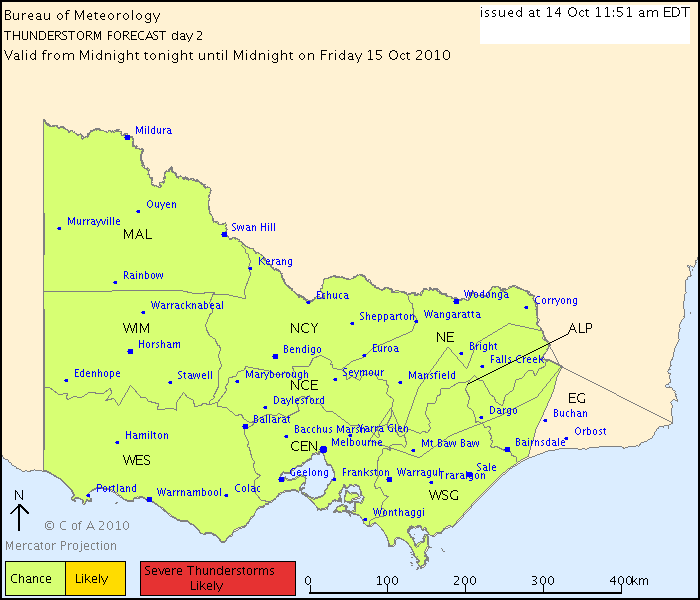
DAY 2 THUNDERSTORM FORECAST
Issued at 11:51 am Thursday, 14 October 2010,
Valid from midnight tonight until midnight on Friday, 15 October 2010.
Cold-air thunderstorms are possible throughout most of Victoria behind a strong
cold front tomorrow. These thunderstorms are unlikely to be severe, although
damaging wind gusts are a possibility. There is only a very small chance of
isolated thunderstorm activity embedded in the rain band ahead of the front.
Heavy falls leading to flash flooding is possible with the rain, however flood
watches are current and a severe weather warning will be issued for this
situation.
Mansfield 370m and Elwood
Re: VIC: Cold outbreak with showers/hail 15-17 October'10
EC's current offering is for near-surface temps to be on a continual downward slippery slope after this arvo (Thu) which doesn't end until early Sat morning. This scenario results in temps diving through the day on Fri and a max temp quite early on during the day with a considerably colder afternoon. If this were to happen and the max temp was reached before the 9am reset, Friday's official max temp could end up being quite low. Of course if it happened after 9am, the official max probably won't be as low.
Incidentally, the spread of the forecast members of the EC ensemble have now tightened up (higher confidence than previously) around a pretty cold late Fri/early Sat scenario.
P.S. forgot to metion, the above scenario is for Melbourne.
Incidentally, the spread of the forecast members of the EC ensemble have now tightened up (higher confidence than previously) around a pretty cold late Fri/early Sat scenario.
P.S. forgot to metion, the above scenario is for Melbourne.
- Gordon
- Supercell
- Reactions:
- Posts: 2939
- Joined: Thu Jun 17, 2010 10:01 am
- Location: Near Gordon, Vic. 620 m asl
Re: VIC: Cold outbreak with showers/hail 15-17 October'10
Thanks for the update Ken - I value your insights. Am I right in thinking that the first scenario is likely to lead to heavier low level snow? (Being 600 m asl with an access road impassable after more than a few cms, I have a keen interest!)
Edit: We're about 80 kms west of the CBD.
Edit: We're about 80 kms west of the CBD.
- vegemitegirl
- Cumulus
- Reactions:
- Posts: 32
- Joined: Tue Jun 22, 2010 11:40 pm
- Location: springvale vic
Re: VIC: Cold outbreak with showers/hail 15-17 October'10
ok this might win dumbest question of the day but.............. what would be the best time to go up to mount dandenong to see snow. Is pin pointing a time too hard?
- Petethemoskeet
- Cumulonimbus
- Reactions:
- Posts: 272
- Joined: Mon Mar 08, 2010 1:06 pm
- Location: Toowoomba
Re: VIC: Cold outbreak with showers/hail 15-17 October'10
I'd say pretty early Sat morning
-
Karl Lijnders
- Tornadic Supercell
- Reactions:
- Posts: 5771
- Joined: Sun Nov 22, 2009 11:17 pm
- Location: Knoxfield, Victoria
Re: VIC: Cold outbreak with showers/hail 15-17 October'10
Early Saturday morning VG!! Steve I would say snow down briefly with heavier showers towards 200m at this time.
Latest 3 Day ACCESS has around 60-80mm across E Central VIC and the low bombing very close to us tomorrow morning.
It is going to be a wild few days and lots of rainfall so I can see the severe weather warnings for flash flooding being issued and damaging winds too and also renewed river flooding in C areas.
Thankfully a few days to dry out till a week from now when we look at the next humid thundery spell.
Former Owner - The Australian Weather Forum. Email me anytime - weatherman1000@hotmail.com
Re: VIC: Cold outbreak with showers/hail 15-17 October'10
Yep sat morning best time.
Anyone seen 00z 3 day ACCESS? All I have to say is wow! A surface low 985hPa just East of Melbourne.
Anyone seen 00z 3 day ACCESS? All I have to say is wow! A surface low 985hPa just East of Melbourne.
- Skywalker
- Supercell
- Reactions:
- Posts: 1884
- Joined: Sun Nov 29, 2009 10:03 am
- Location: Burnside Heights/Cowes (Home) & Sunshine West (Work)
Re: VIC: Cold outbreak with showers/hail 15-17 October'10
What are we looking at around the western parts of Melbourne guys. Getting pretty excited about this system. Bright sunshine here with a moderate northerly at present.
Caroline Springs, Melbourne's meteorological boredom zone.
-
Blackee
- Site Admin/Moderator
- Reactions:
- Posts: 3869
- Joined: Tue Nov 24, 2009 8:57 pm
- Location: Elwood and Mansfield 370m
Re: VIC: Cold outbreak with showers/hail 15-17 October'10
As Karl mentioned earlier, a Severe Weather Warning would be issued.
Severe Weather Warning
for damaging winds
for people in the Alpine Areas, Western, North Central, Central, West and South Gippsland, East Gippsland and Northeast forecast districts
Issued at 1:07 pm EDT on Thursday 14 October 2010.
Weather Situation
A strong cold front south of the Bight will continue to intensify as it approaches Victoria, reaching southwest Victoria later tonight, central Victoria by dawn Friday and then clearing eastern areas of the State by early Friday afternoon.
Damaging winds averaging 60 km/h with peak gusts to around 90 km/h and heavy rain are forecast for the Alpine Areas and Northeast forecast districts and parts of the Western, North Central, Central, West and South Gippsland and East Gippsland forecast districts Thursday night and during Friday as an intense cold front sweeps across the State. Behind the change wintry conditions will arrive with hail and thunder and snow showers on the ranges above 500m.
Mansfield 370m and Elwood
- Lily
- Supercell
- Reactions:
- Posts: 4014
- Joined: Wed Nov 25, 2009 10:29 pm
- Location: Rowville/Lysterfield
Re: VIC: Cold outbreak with showers/hail 15-17 October'10
Wooohooo 
(Apologies for not having anything more useful to add to the thread, just expressing my excitement lol).
(Apologies for not having anything more useful to add to the thread, just expressing my excitement lol).
-
Blackee
- Site Admin/Moderator
- Reactions:
- Posts: 3869
- Joined: Tue Nov 24, 2009 8:57 pm
- Location: Elwood and Mansfield 370m
Re: VIC: Cold outbreak with showers/hail 15-17 October'10
850T from 18z GFS run produced the following:
Fri @ 2000: -3 for most of southern VIC (Ex. Gippsland)
Fri @ 2300: -4 for most of southern VIC (Ex. Gippsland) and pushing into Bendigo
Sat @ 0200: -4 Statewide
Sat @ 0500: -4 & -5 Statewide
Sat @ 0800: -5 thru Western, Central, Nth Central, Nth Country & North East
That is would the window for snowfalls.
Mansfield 370m and Elwood
-
Karl Lijnders
- Tornadic Supercell
- Reactions:
- Posts: 5771
- Joined: Sun Nov 22, 2009 11:17 pm
- Location: Knoxfield, Victoria
Re: VIC: Cold outbreak with showers/hail 15-17 October'10
Generally looking at snowfalls down to 600m by tomorrow afternoon and then 400m by late tomorrow night into Saturday morning, again any locally heavy precip can force snowfalls down further without settling.
Settling level for snowfalls IMO will be 400m and flurries at 200m.
So higher suburbs like Mitcham and Ringwood are a chance too.
Temps not bad at the moment, should see things gradually worsen later today over the NW and in 8hrs time, a lot of colour on the radar in W VIC. I might go to bed when I get home so I can get up at 3am!!
Skywalker, your looking at reasonable rain tomorrow morning, very windy conditions from tomorrow afternoon out on the plains with scattered showers, hail and isolated thunder. Conditions like this will favour the eastern suburbs more but due to the nature of the system, you will get what we get out here in a normal frontal system and SW flow, if that makes sense.
25mm out there. Up to 100mm now out east is possible.
Former Owner - The Australian Weather Forum. Email me anytime - weatherman1000@hotmail.com
Re: VIC: Cold outbreak with showers/hail 15-17 October'10
Anyone familiar with the appearance of snow on the BOM radar? Does it just look like ordinary precip, or are there any telltale signs..?
- Twister
- Cumulonumbus Calvas
- Reactions:
- Posts: 914
- Joined: Sun Nov 29, 2009 10:47 pm
- Location: Brisbane Qld
Re: VIC: Cold outbreak with showers/hail 15-17 October'10
Huge System Much like the Sept system but more E this time
The Big thing to watch is the Cloud in N SA and S NT can see it explode and thicken this cloud is deep, thick and heavy also quite bright on sat pic.
Rain band already stretches from Woomera to Alice springs it looks VERY VERY good
HUGE falls expected For Much of NSW QLD and Central, E, NE, Vic.
Think we will see solid flooding once again in NE Vic with a good 50-80mm with this rain band and up to 100mm or so in mounts on top of all the rain last 6 few days WOW
Rain starting to come into radar in SA atm and the Cloud over N SA is going off like a bomb and diving SE
Looking at only 10-15mm here as will be just on edge hope for 20mm but might have to be happy with 10 but had 13 so far so not bad week at all.
Cold air field is huge and heading straight into this warm humid air mass no wonder such a big and heavy rain band will form on the edge the air masses.
Yes snow to 500mm looking great if you live at or above that watch out Friday night and Saturday morning
SA radar really picking up I have to work 3am to 1pm which i thin k is when it all happen sucks i will miss most of it.
this time tomorrow things will be very wild wet and windy
Now Living in Wet QLD
Re: VIC: Cold outbreak with showers/hail 15-17 October'10
Latest 00z UKMET has the low bombing to 990hPa just East of Melbourne mid to late morning then down to 984hPa near Orbost 4pm tomorrow! Looks very similar to 3 day ACCESS
-
daviescr

- Supercell
- Reactions:
- Posts: 1394
- Joined: Wed Dec 02, 2009 5:40 pm
- Location: Warranwood, Vic
Re: VIC: Cold outbreak with showers/hail 15-17 October'10
Great question Ryan.
Dusting off my toboggan tonight
Dusting off my toboggan tonight