Welcome New Members! We want to hear from you. Register, stop lurking and start posting!

VIC: Severe Wind Event - Spring Fronts. Sep 2-8 2012

Archived Weather Events since 2009.
If you have any valuable content to add to any locked thread, please PM board moderator.
User avatar
apocalypse
Cumulonumbus Calvas
Reactions:
Posts: 761
Joined: Tue Jan 19, 2010 6:17 pm
Location: Wagga Wagga, NSW 189m asl

Re: VIC: Cold Front - Warmth, Rain, Storms, Snow Sept 2-8 20

Post by apocalypse »

Lovely transition between the primary low centre and the secondary low spinning up this afternoon. You can see how the first one weakens and moves north overnight, and convection begins to rotate around the second one today.

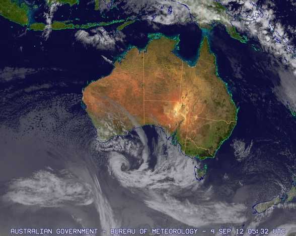
To see, animate the satpic from the beginning of Monday.
http://www.bom.gov.au/australia/satellite/" onclick="window.open(this.href);return false;

For keep sake..
Image
Nathan Morris
2013 Rainfall
Jan - 3.8mm
Feb - 27.0mm
Mar - 0.0mm
YTD - 30.8mm
I
I_Love_Storms
Supercell
Reactions:
Posts: 2812
Joined: Wed Dec 02, 2009 2:01 pm
Location: Hawthorn

Re: VIC: Cold Front - Warmth, Rain, Storms, Snow Sept 2-8 20

Post by I_Love_Storms »

Gale force wind to lash Melbourne
Posted by: 3AW Radio | 4 September, 2012 - 5:29 PM

Gale force winds are expected to sweep across the state throughout the night and bear down on the city come morning.

The weather bureau says the gusts of up to 120 kilometres per hour will last for around five hours from 8 o'clock in the morning.

SES director Andrew Gissing says people need to take precautions and avoid going outside if necessary.

The strong northerly winds are expected to keep overnight temperatures high, with the mercury not expected to drop below 16 degrees tonight.

Cooler conditions are expected to return on Thursday, when snow is forecast to fall down to 1500 metres, lowering to 1100 metres on Friday.

The last time winds of this strength lashed at the state was in April 2008 and the SES recieved 5000 calls for help.

http://www.3aw.com.au/blogs/breaking-ne ... 25c9y.html" onclick="window.open(this.href);return false;
User avatar
Karl Lijnders
Tornadic Supercell
Reactions:
Posts: 5771
Joined: Sun Nov 22, 2009 11:17 pm
Location: Knoxfield, Victoria

Re: VIC: Severe Wind Event - Spring Fronts. Sep 2-8 2012

Post by Karl Lijnders »

Forecasts are updated on the main page and will be updated as we go through the event. Johnno has done tonights forecast and I will take a look later on at current conditions. Jake to look at things tomorrow.

In the meantime strap yourselves in for a gale and a half. Really strong pressure gradient, high winds, destructive gusts and nice warm temps to start tomorrow across the city with a smattering of sunshine. Rain will move into the west and north early but have little impact in Central areas away from the northern slopes.

Winds will ease tomorrow afternoon with the passage of the front, possible storm with that but mainly dry with winds easing.

Those winds to spring up again tomorrow night with more damage possible, this time over the coastal fringes and in the south. So lots of weather to get too.

Nice cold outbreak across the weekend and fine again next week with warm temps!

Spring is here!!!
Former Owner - The Australian Weather Forum. Email me anytime - weatherman1000@hotmail.com
User avatar
mick
Supercell
Reactions:
Posts: 1453
Joined: Mon Nov 30, 2009 6:45 pm
Location: Mid North SA Baaaaaaaaaaaaaaa

Re: VIC: Severe Wind Event - Spring Fronts. Sep 2-8 2012

Post by mick »

Geeze youre a bit slow on the bandwagon karl. Its after sept 1, so no spare seats.

September gales, were a lil bit early this year, didnt have any last year, but september gales in Vic and melb are an historical fact. Its also fact that everyones memory pre internet has been erased. Everything seems to run together now. During the drought we were getting then early august, gone by sept, but by then it felt like summer, so I guess people didnt notice them.

There is a wisp of dark grey cloud way out past the heads on the horizon, be a shower in it for sure.

I dunno where all these damaging winds were today. I think the media has forced the BOM to issue a lot of just in case warnings since black saturday. The weather became an interesting topic, the media calls up, they want something to report.

Looking at the sat pics, I cant see anything we havent had before, not even this year. Looking a bit over hyped to me, but I live in hope.

Nice sunset

http://www.syc.com.au/weather/webcam/" onclick="window.open(this.href);return false;
w
wobbie
Cumulonimbus
Reactions:
Posts: 149
Joined: Mon Nov 30, 2009 9:45 pm
Location: Knox

Re: VIC: Severe Wind Event - Spring Fronts. Sep 2-8 2012

Post by wobbie »

mick » Tue Sep 04, 2012 7:02 pm wrote:
mick wrote:
September gales, were a lil bit early this year, didnt have any last year, but september gales in Vic and melb are an historical fact. Its also fact that everyones memory pre internet has been erased. Everything seems to run together now. During the drought we were getting then early august, gone by sept, but by then it felt like summer, so I guess people didnt notice them.
I seem to remember many severe wind events up here as a kid (in the 90's)... You know those ones where trees and power lines would be all over the joint. Then it just stopped and I assumed all the big trees around my place had fallen down :D
I
I_Love_Storms
Supercell
Reactions:
Posts: 2812
Joined: Wed Dec 02, 2009 2:01 pm
Location: Hawthorn

Re: VIC: Severe Wind Event - Spring Fronts. Sep 2-8 2012

Post by I_Love_Storms »

Wind picking up here. A bit worried about this event, it's a much more prolonged wind storm than usual. If it goes westerly and wild as predicted by EC on Friday night there is bound to be very widespread damage.
G
Geoff
Supercell
Reactions:
Posts: 2538
Joined: Tue Jul 05, 2011 9:46 pm
Location: Olinda VIC (470m ASL)

Re: VIC: Severe Wind Event - Spring Fronts. Sep 2-8 2012

Post by Geoff »

Wind just beginning to get that ominous "roar" in the treetops around here, but it comes in fits and starts and dies off at times. Expecting it to get much worse as the night progresses, so am filling water containers in case/when the power goes off. :(
AWF Rainfall Details - Monthly rainfall stats. Please post your totals here at the end of each month, thank you
http://www.theaustralianweatherforum.co ... &start=180
User avatar
apocalypse
Cumulonumbus Calvas
Reactions:
Posts: 761
Joined: Tue Jan 19, 2010 6:17 pm
Location: Wagga Wagga, NSW 189m asl

Re: VIC: Severe Wind Event - Spring Fronts. Sep 2-8 2012

Post by apocalypse »

Calm before the storm here with only a light easterly. Not expecting it to be as bad as down south and in western NSW, but we still could see 70km/h+ tomorrow, and probably moderating a bit with next front.

It's beginning to spark up a bit ahead of the front in SA, so a lightning show isn't out of the question yet!

Stay safe everyone.
Nathan Morris
2013 Rainfall
Jan - 3.8mm
Feb - 27.0mm
Mar - 0.0mm
YTD - 30.8mm
T
Twiggy
Cumulus
Reactions:
Posts: 67
Joined: Wed Nov 09, 2011 6:19 pm
Location: Loddon Valley, Bears Lagoon.

Re: VIC: Severe Wind Event - Spring Fronts. Sep 2-8 2012

Post by Twiggy »

As always, nothing exciting here!! :( Nice and calm, with the occasional light breeze. I am thinking we should move our farm to Melbourne hahaha or NE of the State... LOL
User avatar
crikey
Supercell
Reactions:
Posts: 1314
Joined: Mon Feb 07, 2011 8:02 pm
Location: tweed shire NSW and nDUNOLLY.. Nth Central district VIC
Contact:

Re: VIC: Severe Wind Event - Spring Fronts. Sep 2-8 2012

Post by crikey »

Twiggy. I am just 50km south of you and we had the most beautiful day
Certainly got the spring gardening green figure bug and the craving for salad and fruit..
All in the space of a week What a change of events here.

No wind here either. I think the strong winds are expected here early tomorrow morning.. to begin

Thanks for that sat animation link of low forming Apocalypse. Brilliant !! :D weather poetry in motion

Here is the current static pic' of that same low
Note the current central pressure is 971 hpascal. What is really outrageous is that the central pressure of 971 sits on the 40 deg S longitude meridian.. :o 8-)

Image

And after posting few days ago saying the Southern hemisphere sat pic had settled down
Another look a few days later and she's looking frisky again. Must be the spring transition? LOL ..Springy!! get it..

It is hard to imagine that the 'eye' of that southern ocean cyclone(a typical : comma) is forecast to be just off the s/west coast of vic on wednesday night/thursday morning..MSLP on the coast could be down to 990..!!
If it edges closer, could be even less!! A good watch tomorrow night..
I
I_Love_Storms
Supercell
Reactions:
Posts: 2812
Joined: Wed Dec 02, 2009 2:01 pm
Location: Hawthorn

Re: VIC: Severe Wind Event - Spring Fronts. Sep 2-8 2012

Post by I_Love_Storms »

83 kph gust at melb airport already
User avatar
Australis(Shell3155)
Supercell
Reactions:
Posts: 3148
Joined: Mon Nov 30, 2009 8:05 pm
Location: FTG
Contact:

Re: VIC: Severe Wind Event - Spring Fronts. Sep 2-8 2012

Post by Australis(Shell3155) »

Might be taking the WS to bed with a torch,
have windows rattling, had to put up the outside blinds earlier in the day as one nearly took off.
Time for the wind chimes to come down, unless you dont really like your neighbours.
Yes do stay safe everyone...
User avatar
daviescr
Supercell
Reactions:
Posts: 1394
Joined: Wed Dec 02, 2009 5:40 pm
Location: Warranwood, Vic

Re: VIC: Severe Wind Event - Spring Fronts. Sep 2-8 2012

Post by daviescr »

Still calm here, often is in the lead up to events like this - we're close to the top of a south facing hill often dont feel the full force of strong northerlies. Will be a different story in a few hours though... expecting tomorrow's commute to be a shocker.

Take care everyone and stay tuned for all the latest updates
User avatar
apocalypse
Cumulonumbus Calvas
Reactions:
Posts: 761
Joined: Tue Jan 19, 2010 6:17 pm
Location: Wagga Wagga, NSW 189m asl

Re: VIC: Severe Wind Event - Spring Fronts. Sep 2-8 2012

Post by apocalypse »

Obs in SA show the very sharp temperature gradient with the front - currently 16.3c in Ceduna and 27.9c in Tarcoola 180km to the NE.

Approx 27c in Mannipa and Wudinna just ahead of the front.
Nathan Morris
2013 Rainfall
Jan - 3.8mm
Feb - 27.0mm
Mar - 0.0mm
YTD - 30.8mm
I
I_Love_Storms
Supercell
Reactions:
Posts: 2812
Joined: Wed Dec 02, 2009 2:01 pm
Location: Hawthorn

Re: VIC: Severe Wind Event - Spring Fronts. Sep 2-8 2012

Post by I_Love_Storms »

Mt William 102 kph. Continuing to ratchet up here. Strongest gusts registering in many areas in last 30 mins
User avatar
Didjman
Supercell
Reactions:
Posts: 2100
Joined: Fri Sep 03, 2010 2:52 pm
Location: Wallan, Vic 328m ASL
Contact:

Re: VIC: Severe Wind Event - Spring Fronts. Sep 2-8 2012

Post by Didjman »

I have sent warning txts to relevant contacts on my mobile. My Wife thinks I am mad! "A stitch in time saves nine!!"
Peter
j
johnno
Supercell
Reactions:
Posts: 3449
Joined: Mon Nov 30, 2009 8:49 am
Location: Ascot Vale

Re: VIC: Severe Wind Event - Spring Fronts. Sep 2-8 2012

Post by johnno »

130kmh gusts at Mt.William past hour
User avatar
Karl Lijnders
Tornadic Supercell
Reactions:
Posts: 5771
Joined: Sun Nov 22, 2009 11:17 pm
Location: Knoxfield, Victoria

Re: VIC: Severe Wind Event - Spring Fronts. Sep 2-8 2012

Post by Karl Lijnders »

Very dry air right across SA and VIC spreading into NSW so lots of dust and pollen flying around today. Looking at winds strengthening rapidly after 8am. Already seen a marked increase with dawn breaking and gusts up over 40 knots on the bays. BoM need to raise the wind warning for the bays immediately - 35 knots is well below the potential average winds of 45 knots today.

Should see winds peak between 8am and 2pm. A band of cloud and perhaps a little rain around the middle of the day but don't expect much. I am not even expecting a thunderstorm, just not the right setup here. If we get either I would be very suprised.

Tonight the winds will be stronger still for southern areas with a more westerly flow setting up and could see winds to 110kmh for many parts of Melbourne. Local damaging gusts of a higher nature will be confined to the coast.

Mild this morning, but trending cooler this afternoon.

Better prospects for rainfall later in the week, 20-30mm possible for parts of southern Victoria. Might even be a mini cold outbreak. One to watch.

Beyond all this, a spring like pattern continues into next week with warmer windy weather ahead of further fronts.
Former Owner - The Australian Weather Forum. Email me anytime - weatherman1000@hotmail.com
G
Geoff
Supercell
Reactions:
Posts: 2538
Joined: Tue Jul 05, 2011 9:46 pm
Location: Olinda VIC (470m ASL)

Re: VIC: Severe Wind Event - Spring Fronts. Sep 2-8 2012

Post by Geoff »

Yes it was a windy night, certainly gale force, but nothing exceptional really. Power is still on here hillybilly, luck of the draw eh?
May be a few trees down if it gets much stronger in the next few hours, as Karl suggests. Warm though, 14.1c currently.
AWF Rainfall Details - Monthly rainfall stats. Please post your totals here at the end of each month, thank you
http://www.theaustralianweatherforum.co ... &start=180
R
Rhino
Supercell
Reactions:
Posts: 1227
Joined: Mon Nov 30, 2009 11:37 am
Location: Carisbrook-Near Maryborough

Re: VIC: Severe Wind Event - Spring Fronts. Sep 2-8 2012

Post by Rhino »

Don't know what to expect here, been a tad windy here but certainly nothing that strong, but that might change soon. Patchy rain to my west and think that will bring the stronger gusts, doppler showing that too. You guys down sth stay safe.

Rhino. :) :)
Locked