Welcome New Members! We want to hear from you. Register, stop lurking and start posting!
Vic - heralding in March with humidity and an Easterly dip!!
Re: Vic - heralding in March with humidity and an Easterly d
8.5mm in the past 24hrs taking Feb total to 219.5mm, I can't remember seen the garden so lush and green at this time of the year.
Re: Vic - heralding in March with humidity and an Easterly d
12mm here from the rain, the *horrible* Flemington station on the BoM only says 3mm. always about half of what i receive. Must be under a highrise flat. 
Go the bombersss!
- droughtbreaker
- Supercell
- Reactions:
- Posts: 2844
- Joined: Wed Nov 25, 2009 7:50 pm
- Location: Mount Macedon, VIC, 520m asl
Re: Vic - heralding in March with humidity and an Easterly d
Very cool week ahead for the state. Not just cool days, but significantly cool nights from about mid week onwards. If anything it is a return to 'normal' early Autumn weather. We should still see some warm spells this month but it looks like it will be generally stable as the anticyclones strengthen up and move a little northwards. With any luck we will see perfect conditions for Autumn colour after a few shockers in recent times.
-
Petros

- Supercell
- Reactions:
- Posts: 2005
- Joined: Tue Dec 01, 2009 6:25 pm
- Location: Maffra, Gippsland, Vic
Re: Vic - heralding in March with humidity and an Easterly d
Go and have a look at that rain gauge site Nafets.
We had 13mm here and not a drop wasted, all falling slowly over 12 hrs, just fantastic.
North Gippsland is green and in my opinion will not whiten off now that we have the onset of Autumn.
Had a couple of beers with other locals and cockies before (golf got cancelled at Maffra), and the group consensus was that "we" (at our average age 55 yo) will never see these conditions again. I must add that the group are confident that normal rain will continue through to next summer - God knows after that. The group of 6 comprises older farmers and slightly younger very amateur weather enthusiests (like me) - no qualifications ,but I bet a slab that we are closer than that Ross Garaunlt (sorry - spelling)!! Those with an opinion in this area which is totally dependant on rain do not believe in carbon induced global warming, yet our school teacher golfers (I DO like school teachers) stand back to back defending it. Each to thier own, but interesting eh?
[edit] - have a look at Tuesday! "Blue cold line" into Bass Straight, and SW squally showers like as if its late May!!!!
-
Supercellimpact

- Supercell
- Reactions:
- Posts: 1241
- Joined: Thu Oct 07, 2010 8:39 pm
- Location: Bendigo
Re: Vic - heralding in March with humidity and an Easterly d
EC has 4mm down for tommorrow here, so the trough must be lingering tommorrow and trigger a few showers and maybe a storm but Storm cast isn't very encourging at all. I reckon the chance of a few showers tommorow is at about 50%.
Re: Vic - heralding in March with humidity and an Easterly d
I'm not sure where it is, does anyone have a clue? ThanksPetros » Sun Feb 27, 2011 6:48 pm wrote:Petros wrote:Go and have a look at that rain gauge site Nafets.
Go the bombersss!
-
daviescr

- Supercell
- Reactions:
- Posts: 1394
- Joined: Wed Dec 02, 2009 5:40 pm
- Location: Warranwood, Vic
Re: Vic - heralding in March with humidity and an Easterly d
Nafets, take a look at Melbourne Water's site for comparison - http://www.melbournewater.com.au/conten ... eID=45#103
The BOM data is probably taken from there, but not at regular intervals - hence the mis-match of numbers (BOM at 3mm, MW at 8.4). Still, significant difference between your 12mm and 8.4mm - more than 30% variation.
Not sure on the actual location, sorry.
The BOM data is probably taken from there, but not at regular intervals - hence the mis-match of numbers (BOM at 3mm, MW at 8.4). Still, significant difference between your 12mm and 8.4mm - more than 30% variation.
Not sure on the actual location, sorry.
- Twister
- Cumulonumbus Calvas
- Reactions:
- Posts: 914
- Joined: Sun Nov 29, 2009 10:47 pm
- Location: Brisbane Qld
Re: Vic - heralding in March with humidity and an Easterly d
Had 7mm here lots of mist and drizzle but stopped mid arvo
Looking at a cool to cold cloudy with showers about week, hurry up high and get into the tasmen
Looking at a cool to cold cloudy with showers about week, hurry up high and get into the tasmen
Now Living in Wet QLD
-
Supercellimpact
- Supercell
- Reactions:
- Posts: 1241
- Joined: Thu Oct 07, 2010 8:39 pm
- Location: Bendigo
Re: Vic - heralding in March with humidity and an Easterly d
Wow !! Horsham have just had 30mm from a storm ! Very unexpected !
- HarleyB
- Cumulonumbus Calvas
- Reactions:
- Posts: 839
- Joined: Sun Oct 10, 2010 9:39 pm
- Location: Wangaratta
Re: Vic - heralding in March with humidity and an Easterly d
Had a nice 8mm over the weekend here.
-
Supercellimpact
- Supercell
- Reactions:
- Posts: 1241
- Joined: Thu Oct 07, 2010 8:39 pm
- Location: Bendigo
Re: Vic - heralding in March with humidity and an Easterly d
If that cell could track a tiny bit north we will get hit, also it's moving quite fast and developing an Inflow or Outflow tail? on the North Eastern Side
-
Karl Lijnders

- Tornadic Supercell
- Reactions:
- Posts: 5771
- Joined: Sun Nov 22, 2009 11:17 pm
- Location: Knoxfield, Victoria
Re: Vic - heralding in March with humidity and an Easterly d
Should see the storms and showers continue across northern areas today with scattered 5-10mm falls and isolated falls up to 50mm.
Former Owner - The Australian Weather Forum. Email me anytime - weatherman1000@hotmail.com
- Microburst
- Cumulus
- Reactions:
- Posts: 32
- Joined: Wed Nov 24, 2010 4:31 pm
- Location: Horsham
Re: Vic - heralding in March with humidity and an Easterly d
18mm here this morning in a huge suprise , not a storm just very humid wet rain, typical of this summer. Incredibly Horsham airport has recorded 43mm just north of Horsham. What will happen for the rest of the day, will it fine up?
-
stratospear

- Supercell
- Reactions:
- Posts: 1261
- Joined: Sat Dec 19, 2009 9:38 am
- Location: Usually Bendigo
Re: Vic - heralding in March with humidity and an Easterly d
Rain band is just missing us. A steep temperature gradient across the state is apparent and it feels like the season is changing right on cue.
- Monbulkian
- Cumulonimbus
- Reactions:
- Posts: 192
- Joined: Thu Nov 11, 2010 9:42 pm
- Location: Monbulk
Re: Vic - heralding in March with humidity and an Easterly d
Had 7.5mm here in Monbulk on Saturday and 1.5mm on Sunday. Will post MTD and YTD tomorrow.
-
Petros
- Supercell
- Reactions:
- Posts: 2005
- Joined: Tue Dec 01, 2009 6:25 pm
- Location: Maffra, Gippsland, Vic
Re: Vic - heralding in March with humidity and an Easterly d
Just mizzle out our way this morning, now very overcast.
-
Supercellimpact
- Supercell
- Reactions:
- Posts: 1241
- Joined: Thu Oct 07, 2010 8:39 pm
- Location: Bendigo
Re: Vic - heralding in March with humidity and an Easterly d
We are going to clip the top of it a few mm maybe.
-
Supercellimpact
- Supercell
- Reactions:
- Posts: 1241
- Joined: Thu Oct 07, 2010 8:39 pm
- Location: Bendigo
Re: Vic - heralding in March with humidity and an Easterly d
Rain coming down now, very tropical feel to it .
-
Supercellimpact
- Supercell
- Reactions:
- Posts: 1241
- Joined: Thu Oct 07, 2010 8:39 pm
- Location: Bendigo
Re: Vic - heralding in March with humidity and an Easterly d
Got 6.2mm out of that, not a bad top up. The temps up north are hot. 
-
Karl Lijnders
- Tornadic Supercell
- Reactions:
- Posts: 5771
- Joined: Sun Nov 22, 2009 11:17 pm
- Location: Knoxfield, Victoria
Re: Vic - heralding in March with humidity and an Easterly d
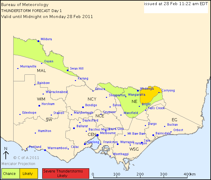
IDV65758
Australian Government Bureau of Meteorology
Victoria Regional Office
THUNDERSTORM FORECAST
Issued at 11:22 am Monday, 28 February 2011,
Valid until midnight on Monday, 28 February 2011.
Very moist air still persisting in the far north and with a trough or surge in the southerly flow moving across the northern border later this afternoon or evening there is still the chance of thunderstorms developing when the trough moves through. Thunderstorms more likely about the far northeast due to higher instability. Drier southerly air should follow the change.
Former Owner - The Australian Weather Forum. Email me anytime - weatherman1000@hotmail.com