Page 20 of 31
Re: Victoria: A humid thundery week - 13th-20th Feb 2011
Posted: Thu Feb 17, 2011 6:30 pm
by schitzengiggles
Are you done for the year or are you having a bash on Sunday?
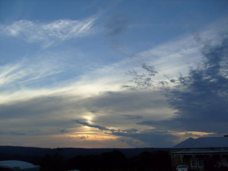
This is the SE side of the one that really threatened today.

Re: Victoria: A humid thundery week - 13th-20th Feb 2011
Posted: Thu Feb 17, 2011 6:45 pm
by flatcam
Just got hit by the cell I mentioned earlier. It didn't drop much rain, but each drop was massive! My driveway is now littered with 1 inch (+) wide splats from the rain. It sound more like hail against the carport.
There appears to be another cell building behind it. Not sure how much it will develop before it gets here though.
Cheers, Cam
Re: Victoria: A humid thundery week - 13th-20th Feb 2011
Posted: Thu Feb 17, 2011 6:47 pm
by Robbo
Warm Sunshine here,if you look South towards the Divide,mega build ups which will surely head to Melbourne.
Re: Victoria: A humid thundery week - 13th-20th Feb 2011
Posted: Thu Feb 17, 2011 6:48 pm
by Jake Smethurst
Okay, I must admit that the BoM thunderstorm chart for today was not the best, however it is worth to be mentioned that predicting thunderstorms with absolute certainty is extremely difficult. I would also like to mention that whilst the BoM have got t'storm charts wrong in the past, they have got many right. There are positives!! There are so many factors to be taken into consideration when preparing a chart like that. Remember it's meant to be for the emergency services' eyes only, and if the bashing of the chart or the BoM is to be had, we will stop posting it altogether.
Re: Victoria: A humid thundery week - 13th-20th Feb 2011
Posted: Thu Feb 17, 2011 6:49 pm
by Anthony Violi
Southerly wasnt really a problem, lack of trigger and no convergence were the main problems.
yesterday the Ne flow was a perfect set up for the convergence zone in the outer suburbs, today the Southerlies were well inland so no forcing mechanism was there. The only place they went off today was nearest the trough where trigger was greatest, most of the short lived ones were in areas that didnt have the extra kick.
Having said that, dont be surprised if we see convergence as the flow shifts NW overnight and activity kicks off during the night.
And the 14mm that Norwegian has for here for the next 72 hours is probably the biggest joke of all time.
Re: Victoria: A humid thundery week - 13th-20th Feb 2011
Posted: Thu Feb 17, 2011 6:51 pm
by AUS_Twisted
Meso wrote:The thunderstorm charts from the BoM are a joke basically. I'd just ignore them, Cam, so as not get your hopes up. How so called professionals can put together something like today's effort really baffles me.
I'd agree for todays (think they went a bit overboard with the red), but yesterdays was fairly accurate from what I saw down SW. I think the Mortlake cell was one of the most organized of the day going by what I've seen from sat pics, radar and seeing it visually. One of the main reasons I went SW yesterday was because of the sat pic, there was big clear areas all day down SW.
Re: Victoria: A humid thundery week - 13th-20th Feb 2011
Posted: Thu Feb 17, 2011 6:53 pm
by Petros
PalmTrees wrote:Petros wrote:PalmTrees wrote: that
- southerly has nailed us to the cross yet again. We just cant seem to escape it this summer on potential storm days.
Try living out here in C Gippsland, Bass Straight seabreaze storm killing is a daily event from Nov onwards.
27.5C here today, muggier I thought than yesterday yet delivered nil here at Maffra. Was fair rain in Traralgon and Sale around midday (circa 3-6mm) but have lost faith in seeing a storm here again today. Its a tough job being a storm watcher when you live in Maffra, and you cant just hop in a car and head N like you can in Melbourne. Gripe gripe grizzle.
This summer just struck me as the summer of the southerly. Ironic how we always complain about a lack of humidity being the problem, when this season we are getting all the humidity in the world, but getting a fairly ordinary storm season, as far as lightning activity and frequency of storm events are concerned. Sure, we got a few big deluges, but electrical activity has been lacking. Still not one night time lightning display.
NE Vic seemed to be getting hammered constantly this season. I think it's time to set up a share house there where we can all hang out!

Can sense your frustration, but didnt you get HUGE STORMS and rain cutting the highway only a week ago? Isnt Berwick sitting way above average for Jan/Feb rainfall?
Re: Victoria: A humid thundery week - 13th-20th Feb 2011
Posted: Thu Feb 17, 2011 7:02 pm
by Petros
Meso wrote:Karl Lijnders wrote: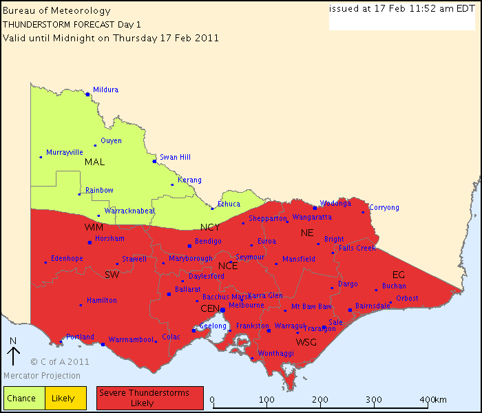
WTF?! BoM continue to embarrass themselves. There is a snowflakes chance in hell of a severe thunderstorm here this afternoon and that goes for most of the western half of the state. But whatever, they're the experts.
Pertinent and spot on observation Meso.
Administrators: - is it possible to include the date/time of the original post when invoking the Quote function? Would add heaps of context to the post and would avoid a lot of flaring because out of context timiness in quotes is very often the root cause of misconceptions/arguments.
Re: Victoria: A humid thundery week - 13th-20th Feb 2011
Posted: Thu Feb 17, 2011 7:13 pm
by daviescr
Good point Petros, we will look into it.
Re: Victoria: A humid thundery week - 13th-20th Feb 2011
Posted: Thu Feb 17, 2011 7:53 pm
by stratospear
A decent bank of cloud with anvils to my West. Very slow moving and quite high based.
Re: Victoria: A humid thundery week - 13th-20th Feb 2011
Posted: Thu Feb 17, 2011 7:58 pm
by AUS_Twisted
I'm to hoping for some better storms for night time as far as lightning photography goes, theres been barely anything down south for that. All the action is currently central and north Australia, take your pick lol
Re: Victoria: A humid thundery week - 13th-20th Feb 2011
Posted: Thu Feb 17, 2011 8:00 pm
by Meso
Power Storm wrote:Okay, I must admit that the BoM thunderstorm chart for today was not the best, however it is worth to be mentioned that predicting thunderstorms with absolute certainty is extremely difficult. I would also like to mention that whilst the BoM have got t'storm charts wrong in the past, they have got many right. There are positives!! There are so many factors to be taken into consideration when preparing a chart like that. Remember it's meant to be for the emergency services' eyes only, and if the bashing of the chart or the BoM is to be had, we will stop posting it altogether.
No need to get upset, Jake. I don't understand why the majority of discussion on here that invokes a bit of heated debate seems to get knocked on the head so quickly. They're a government organization and should be open to criticism like anyone else.
Anyway, I totally understand how hard it is to predict thunderstorms. I'm sure we all do. And yes, they have got it right a few times too. But, to have such a wide area of red "severe thunderstorms likely" today, was just mind boggling. I'd love to know their reasoning behind it. Add to that, no yellow area, just "chance" outside the red area makes it really hard to make any sense out of it. Unfortunately today's chart didn't come with much insight about their reasoning, like they seem to do a majority of the time. Maybe someone on work experience got the job doing todays?

To add something constructive to my "bashing" of the chart...I think the problem lies in the system they use for these charts. The gab between the terms "chance", "likely" and "
Severe thunderstorms likely", means they leave themselves open to being perceived as getting it wrong a lot of the time. As I suggested to you, maybe a percentage model or something else might prove to be a bit more accurate.
Re: Victoria: A humid thundery week - 13th-20th Feb 2011
Posted: Thu Feb 17, 2011 8:06 pm
by norfolk
So hands up who is glad there were only a few instances of storms today? A day with not many storms about is a day the state can dry up!
My hands are up!! hahaha
Re: Victoria: A humid thundery week - 13th-20th Feb 2011
Posted: Thu Feb 17, 2011 8:15 pm
by schitzengiggles
Meso the way I see it is, there's two distinctly separate definitions of thunderstorms.
I was explaining to someone the other day that on this particular forum, there's two distinct type of nerds. (We're all nerds - I hope nobody takes offence here, there's certainly none intended.)
There's the storm nerd; Myself, yourself, Hamlan, Rikki, so on and so forth.. then, there's the weather nerd; I won't name names here, but I'll go as far as to suggest those that keep rainfall totals, discuss climate change, sea surface temperatures etc.
I think that the storm nerd's definition of thunderstorms is something that's entirely different the definition of thunderstorms according to the weather nerds. The BOM's definition of thunderstorm seems to align with that of the weather nerd. Where the storm nerd sees/discusses severe, he/she is thinking damaging winds, hail, sparkies, rotation, structure........ where the BOM and the weather nerd discussing thunderstorms is nine times out of ten referring to rumbly rain, red cores on the radar, and associated phenomena - flash flooding is a classic. The discrepancy is highlighted I see a "severe" warning from the BOM because of flash flooding and think wtf? it's only water, could be a lot worse!
I think if you take into consideration the above and try to change perspectives, the BOM and Jake too (charts are so often so similar) get it pretty well right, enough of the time to certainly justify their existence.
I could well be wrong here, but it's taken me a little while to work out how to justify things to myself, and this is the most logical explanation I could come up with.
Please don't get up in arms about the term nerd. It's entirely interchangable. If you're upset, we'll change the word to jellybean.
Re: Victoria: A humid thundery week - 13th-20th Feb 2011
Posted: Thu Feb 17, 2011 8:19 pm
by Robbo
Looking West toward Ballarat from Daylesford,all Quiet up here .
Re: Victoria: A humid thundery week - 13th-20th Feb 2011
Posted: Thu Feb 17, 2011 8:39 pm
by gerta
stratospear wrote:A decent bank of cloud with anvils to my West. Very slow moving and quite high based.
Hearing things about flash flooding in Inglewood again. Sounds like them and Wedderburn have copped some more rain.
Re: Victoria: A humid thundery week - 13th-20th Feb 2011
Posted: Thu Feb 17, 2011 8:45 pm
by Petros
norfolk wrote:So hands up who is glad there were only a few instances of storms today? A day with not many storms about is a day the state can dry up!
My hands are up!! hahaha
You are so out of touch with the rainfall across all of Vic.
Re: Victoria: A humid thundery week - 13th-20th Feb 2011
Posted: Thu Feb 17, 2011 8:48 pm
by norfolk
Petros wrote:norfolk wrote:So hands up who is glad there were only a few instances of storms today? A day with not many storms about is a day the state can dry up!
My hands are up!! hahaha
You are so out of touch with the rainfall across all of Vic.
Yes I must admit, Gippsland seems to have missed out on the wetness of the rest of the state. So I whole heartedly apologise for this oversight!
Re: Victoria: A humid thundery week - 13th-20th Feb 2011
Posted: Thu Feb 17, 2011 8:52 pm
by Petros
schitzengiggles wrote:Meso the way I see it is, there's two distinctly separate definitions of thunderstorms.
I was explaining to someone the other day that on this particular forum, there's two distinct type of nerds. (We're all nerds - I hope nobody takes offence here, there's certainly none intended.)
There's the storm nerd; Myself, yourself, Hamlan, Rikki, so on and so forth.. then, there's the weather nerd; I won't name names here, but I'll go as far as to suggest those that keep rainfall totals, discuss climate change, sea surface temperatures etc.
I think that the storm nerd's definition of thunderstorms is something that's entirely different the definition of thunderstorms according to the weather nerds. The BOM's definition of thunderstorm seems to align with that of the weather nerd. Where the storm nerd sees/discusses severe, he/she is thinking damaging winds, hail, sparkies, rotation, structure........ where the BOM and the weather nerd discussing thunderstorms is nine times out of ten referring to rumbly rain, red cores on the radar, and associated phenomena - flash flooding is a classic. The discrepancy is highlighted I see a "severe" warning from the BOM because of flash flooding and think wtf? it's only water, could be a lot worse!
I think if you take into consideration the above and try to change perspectives, the BOM and Jake too (charts are so often so similar) get it pretty well right, enough of the time to certainly justify their existence.
I could well be wrong here, but it's taken me a little while to work out how to justify things to myself, and this is the most logical explanation I could come up with.
Please don't get up in arms about the term nerd. It's entirely interchangable. If you're upset, we'll change the word to jellybean.
Pretty much right from my perspective violet... by your description I, for one, fit neatly into your "weather nerd" designation and havent got a problem with your categorisation - .....and certainly dont take any offence.
Re: Victoria: A humid thundery week - 13th-20th Feb 2011
Posted: Thu Feb 17, 2011 9:09 pm
by schitzengiggles
*wipes sweat off brow*