Welcome New Members! We want to hear from you. Register, stop lurking and start posting!
Victoria: Rain/Storm event: 29th Nov - 5th Dec (Obs)
-
Supercellimpact

- Supercell
- Reactions:
- Posts: 1241
- Joined: Thu Oct 07, 2010 8:39 pm
- Location: Bendigo
Re: Victoria: Rain/Storm event: 29th Nov - 5th Dec (Obs)
That cell to the north nathalia has a brown core and has had one for about 15 mins.
-
Blackee

- Site Admin/Moderator
- Reactions:
- Posts: 3868
- Joined: Tue Nov 24, 2009 8:57 pm
- Location: Elwood and Mansfield 370m
Re: Victoria: Rain/Storm event: 29th Nov - 5th Dec (Obs)
Credit where credit is due, well done to BOM in issuing the SWW for Flash Flooding so early.
I have heard the advice being broadcast on four different radio stations so far!
After 90mins of steady, light rain, it has ceased with conditions becoming brighter by the minute.
The phrase "Chaos & Mayhem" will be suitable to use this afternoon. Tis going to get very, very nasty!! If we get to the forecast temp of 26 then it will be happy hour for Thor!!
Mansfield 370m and Elwood
- Jake Smethurst
- Supercell
- Reactions:
- Posts: 3583
- Joined: Mon Nov 23, 2009 8:49 pm
- Location: Cheltenham
Re: Victoria: Rain/Storm event: 29th Nov - 5th Dec (Obs)
My storm chart for today!! Enjoy.
Thunderstorm Forecast - Day 1 (Thursday) Issued 11:20 AM EDT 2/12/2010
A trough of low pressure is currently sitting over western Victoria, directing a very moist northeasterly airflow of Victoria, and a volatile atmosphere. Current recordings of dew points are in the high teens across most parts of the state. Scattered thunderstorms are likely to develop over most of Victoria today, particularly this afternoon, thanks to hot surface temperatures and colder air aloft. There is a lesser chance of thunderstorms in the northwest today thanks to a more stable atmospheric environment. Severe thunderstorms are highly likely through the area mentioned below today thanks to stronger instability and the general prime area of development. Severe thunderstorms today are likely to bring flash flooding, large hailstones and possibly damaging winds. There is the risk of supercell activity today, particularly in the 'red' area mentioned below, and due to the nature of supercells, tornadoes cannot be ruled out. Motion of thunderstorm activity today should be south to southwest, but tending more southwest over southern regions. Please note that at the issue time of this chart, severe thunderstorms were already located northwest of Yarrawonga.
Jake - Senior AWF Forecaster
Feel free to send me a private message if you have any questions.
Feel free to send me a private message if you have any questions.
-
Blackee
- Site Admin/Moderator
- Reactions:
- Posts: 3868
- Joined: Tue Nov 24, 2009 8:57 pm
- Location: Elwood and Mansfield 370m
Re: Victoria: Rain/Storm event: 29th Nov - 5th Dec (Obs)
Courtesy of the Bureau of Meteorology.
Fire Weather Briefing for Victoria
Issued at 10:50 am EDT on Thursday 2 December 2010.
Estimates Today:
The fire weather forecast should provide good guidance for this afternoon.
There is probably the potential for maximum temperatures to be a couple of
degrees higher, however it is assumed that convective cloud will build this
afternoon with showers and thunderstorms. Wind speed at the time of maximum
temperature may be a touch lower than forecast. at 10.45am the Yarrawonga
weather radar was showing a massive storm tracking toward Tocumwal, perhaps a
sign of things to come this afternoon for other parts of the State.
Weather Situation:
A strong and slow-moving high pressure system over the Tasman Sea is producing
a moist easterly airstream over Victoria. A low pressure system will form over
Western Australia during Saturday before moving over the Bight by Sunday.
24 Hour Rainfall to 9am:
Once again showers and thunderstorms were observed across Victoria over the
last 24 hours with rainfall totals varying greatly. Some of the higher rainfall
totals included 47mm at Croydon, 41mm at Melbourne Airport and 29mm at the
Basin in the Dandenongs.
Weather Today:
Scattered showers and thunderstorms near and south of the ranges with locally
heavy falls. Isolated showers and thunderstorms elsewhere. Mild to warm and
humid with light to moderate north to northeasterly winds and afternoon coastal
sea breezes.
Mansfield 370m and Elwood
- Harley34
- Cumulonumbus Calvas
- Reactions:
- Posts: 580
- Joined: Sat Mar 06, 2010 1:08 pm
- Location: Ringwood East, Melbourne
Re: Victoria: Rain/Storm event: 29th Nov - 5th Dec (Obs)
Can't wait for that BOM TS Chart!
-
Supercellimpact
- Supercell
- Reactions:
- Posts: 1241
- Joined: Thu Oct 07, 2010 8:39 pm
- Location: Bendigo
Re: Victoria: Rain/Storm event: 29th Nov - 5th Dec (Obs)
It will look pretty much the same mate.Harley34 wrote:Can't wait for that BOM TS Chart!
- Monbulkian
- Cumulonimbus
- Reactions:
- Posts: 192
- Joined: Thu Nov 11, 2010 9:42 pm
- Location: Monbulk
Re: Victoria: Rain/Storm event: 29th Nov - 5th Dec (Obs)
Added only 1.5mm overnight to give me a total of 13.5 mm for the 1st Dec. This morning we have had 7.5mm. Currently we have some blue sky and sunshine
- Harley34
- Cumulonumbus Calvas
- Reactions:
- Posts: 580
- Joined: Sat Mar 06, 2010 1:08 pm
- Location: Ringwood East, Melbourne
Re: Victoria: Rain/Storm event: 29th Nov - 5th Dec (Obs)
Sun's out now 
Feels quite hot in the sun, and very humid.
Feels quite hot in the sun, and very humid.
- Harley34
- Cumulonumbus Calvas
- Reactions:
- Posts: 580
- Joined: Sat Mar 06, 2010 1:08 pm
- Location: Ringwood East, Melbourne
Re: Victoria: Rain/Storm event: 29th Nov - 5th Dec (Obs)
IDV65756
Australian Government Bureau of Meteorology
Victoria Regional Office
TOP PRIORITY FOR IMMEDIATE BROADCAST
SEVERE THUNDERSTORM WARNING
for DAMAGING WIND, FLASH FLOODING and LARGE HAILSTONES
For people in the
Northern Country and parts of the
Mallee,
North Central and
North East s.
Issued at 11:44 am Thursday, 2 December 2010.
Severe thunderstorms are likely to produce damaging winds, very heavy rainfall, flash flooding and large hailstones in the warning area over the next several hours. Locations which may be affected include Bendigo, Echuca, Shepparton, Seymour, Wodonga and Wangaratta.
-
Supercellimpact
- Supercell
- Reactions:
- Posts: 1241
- Joined: Thu Oct 07, 2010 8:39 pm
- Location: Bendigo
Re: Victoria: Rain/Storm event: 29th Nov - 5th Dec (Obs)
For melbourne it will be a conveyor belt of storms, get ready melbourne!! 
-
Blackee
- Site Admin/Moderator
- Reactions:
- Posts: 3868
- Joined: Tue Nov 24, 2009 8:57 pm
- Location: Elwood and Mansfield 370m
Re: Victoria: Rain/Storm event: 29th Nov - 5th Dec (Obs)
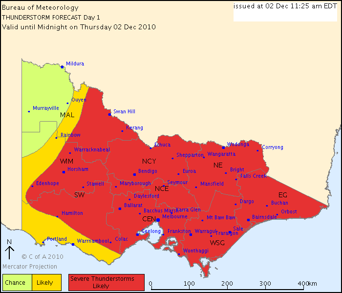
Courtesy of the Bureau of Meteorology
IDV65758
Australian Government Bureau of Meteorology
Victoria Regional Office
THUNDERSTORM FORECAST
Issued at 11:25 am Thursday, 2 December 2010,
Valid until midnight on Thursday, 2 December 2010.
The airmass is unstable again today with very high moisture levels. Severe
thunderstorms are likely to develop during the afternoon and produce heavy
rainfall and flash flooding throughout a good part of the state. There is a
lesser chance in the northwest with a cold pool moving southwards.
Mansfield 370m and Elwood
- Jake Smethurst
- Supercell
- Reactions:
- Posts: 3583
- Joined: Mon Nov 23, 2009 8:49 pm
- Location: Cheltenham
Re: Victoria: Rain/Storm event: 29th Nov - 5th Dec (Obs)
Harley, the BoM TS chart looks like mine mate, except their 'severe' area extends slightly further west than mine, and theirs covers the entire east.
About to hear the BoM on the local radio, can't wait to hear what they have to say.
Fairly nasty storm off Cape Paterson atm.
Lots of thunderstorms developing through central parts atm too.
About to hear the BoM on the local radio, can't wait to hear what they have to say.
Fairly nasty storm off Cape Paterson atm.
Lots of thunderstorms developing through central parts atm too.
Jake - Senior AWF Forecaster
Feel free to send me a private message if you have any questions.
Feel free to send me a private message if you have any questions.
-
Supercellimpact
- Supercell
- Reactions:
- Posts: 1241
- Joined: Thu Oct 07, 2010 8:39 pm
- Location: Bendigo
Re: Victoria: Rain/Storm event: 29th Nov - 5th Dec (Obs)
Hey, what time does that come on ? 12.05 is it?Power Storm wrote:Harley, the BoM TS chart looks like mine mate, except their 'severe' area extends slightly further west than mine, and theirs covers the entire east.
About to hear the BoM on the local radio, can't wait to hear what they have to say.
Fairly nasty storm off Cape Paterson atm.
Lots of thunderstorms developing through central parts atm too.
Re: Victoria: Rain/Storm event: 29th Nov - 5th Dec (Obs)
So much for the showers and storms being on and South of the ranges! Mabye BOM need to look towards the NSW Border of whats to come! Doesn't look that "Isolated" to me!
Re: Victoria: Rain/Storm event: 29th Nov - 5th Dec (Obs)
flower me, look at the charts..
Look at stormcast.., satpic and all the obs around the state.
Where the bloody hell do I go?.....
Look at stormcast.., satpic and all the obs around the state.
Where the bloody hell do I go?.....
Re: Victoria: Rain/Storm event: 29th Nov - 5th Dec (Obs)
I'm very confused here. Why is the above chart from Powerstorm like that yet when I just looked on the BOM site it only has this one??
- Attachments
-
- IDV65643.gif (15.29 KiB) Viewed 6030 times
Last edited by Ausmammal on Thu Dec 02, 2010 11:58 am, edited 1 time in total.
- Harley34
- Cumulonumbus Calvas
- Reactions:
- Posts: 580
- Joined: Sat Mar 06, 2010 1:08 pm
- Location: Ringwood East, Melbourne
Re: Victoria: Rain/Storm event: 29th Nov - 5th Dec (Obs)
Stay in Doncaster, you're fine where you are.schitzengiggles wrote:**** me, look at the charts..
Look at stormcast.., satpic and all the obs around the state.
Where the bloody hell do I go?.....
Re: Victoria: Rain/Storm event: 29th Nov - 5th Dec (Obs)
The one that the boffins just published is speculative, the one on the website is active.
Re: Victoria: Rain/Storm event: 29th Nov - 5th Dec (Obs)
Oh ok.... Boffins on here is their map. BOM is their map.schitzengiggles wrote:The one that the boffins just published is speculative, the one on the website is active.
What one is more accurate?
-
tizza

- Cumulonumbus Calvas
- Reactions:
- Posts: 728
- Joined: Wed Nov 25, 2009 6:48 pm
- Location: Dandenong North
- Contact:
Re: Victoria: Rain/Storm event: 29th Nov - 5th Dec (Obs)
OK the sun is out here now and there's steam coming off everything, the road, fence, etc.... It's going to be a cracking afternoon!!!!