AWF SEVERE THUNDERSTORM ADVICE
Please use official warnings from the Bureau of Meteorology for professional services.
Isolated thunderstorms are currently being observed on weather radar across parts of southern Victoria. The areas of main interests are over the Southwest, and South Gippsland regions. These thunderstorms are capable of producing flash flooding, and damaging winds and large hailstones to a lesser extent.
Please note that a cell northeast of FRANKSTON is likely to produce flash flooding.
URGENT MESSAGE: Severe thunderstorms have been identified on weather radar over the states southwest. A cell to the east of CASTERTON is likely to produce flash flooding and large hailstones ... COLERAINE and CAVENDISH will be affected. A second severe cell to the southwest of CASTERTON is also likely to produce flash flooding and large hailstones ... this cell is likely to affect MERINO. A third cell to the south of DARTMOOR is showing some severe signatures, however this is not yet considered severe. Otherwise, weather radar indicates a cell northeast of LEONGATHA that is likely to produce flash flooding and large hailstones.

Welcome New Members! We want to hear from you. Register, stop lurking and start posting!
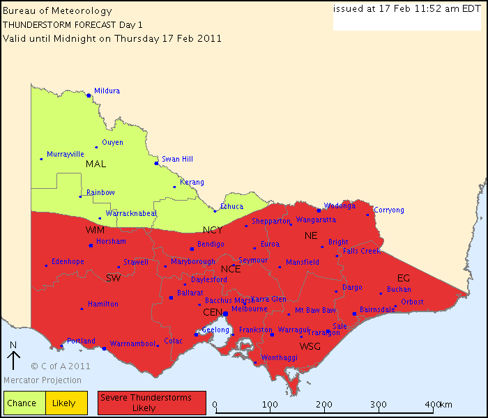
Victoria: A humid thundery week - 13th-20th Feb 2011
- Jake Smethurst
- Supercell
- Reactions:
- Posts: 3583
- Joined: Mon Nov 23, 2009 8:49 pm
- Location: Cheltenham
Re: Victoria: A humid thundery week - 13th-20th Feb 2011
Jake - Senior AWF Forecaster
Feel free to send me a private message if you have any questions.
Feel free to send me a private message if you have any questions.

Re: Victoria: A humid thundery week - 13th-20th Feb 2011
WTF?! BoM continue to embarrass themselves. There is a snowflakes chance in hell of a severe thunderstorm here this afternoon and that goes for most of the western half of the state. But whatever, they're the experts.Karl Lijnders wrote:
Re: Victoria: A humid thundery week - 13th-20th Feb 2011
Been keeping an eye on that Cranbourne cell that died then re-intensified. Certainly built up again...very nice cloud formations. Hope it gets here!!
- Lily
- Supercell
- Reactions:
- Posts: 4014
- Joined: Wed Nov 25, 2009 10:29 pm
- Location: Rowville/Lysterfield
Re: Victoria: A humid thundery week - 13th-20th Feb 2011
Yep, flangfest, I've been watching that too, looks like we might be getting lined up for it 
Re: Victoria: A humid thundery week - 13th-20th Feb 2011
And now I jinxed it and it's dissipating!! Maybe it will rebuild over my house... we get everything hereLily wrote:Yep, flangfest, I've been watching that too, looks like we might be getting lined up for it
-
Instability

- Cumulonimbus
- Reactions:
- Posts: 290
- Joined: Thu Nov 26, 2009 6:26 am
- Location: Live in Burwood - Work in Dandenong South
Re: Victoria: A humid thundery week - 13th-20th Feb 2011
Just went out and had a look at that cell north of Frankston from Brandon Park - it and a lot of the development around it is BIG!! Will be interesting to see how the line interacts with the ranges once it gets that far north.
Rog.
Rog.
-
AUS_Twisted

- Storm Chaser
- Reactions:
- Posts: 652
- Joined: Wed Nov 25, 2009 6:15 pm
- Location: Dandenong North, Melb
Re: Victoria: A humid thundery week - 13th-20th Feb 2011
Heard 1 rumble from that cell thats near Dandenong now, it's falling apart and can't see any rain dropping from it either.
Edit: It's kind of all over the place, not very organized though.
Edit: It's kind of all over the place, not very organized though.
-
Karl Lijnders

- Tornadic Supercell
- Reactions:
- Posts: 5771
- Joined: Sun Nov 22, 2009 11:17 pm
- Location: Knoxfield, Victoria
Re: Victoria: A humid thundery week - 13th-20th Feb 2011
Just bouncing around those cells so they will die but invigorate the convection close by as the parent cells collapse and form new cells out of existing convection...if that makes sense - LOL!!
BTW keep an eye for the King Island stuff to make impact on coastal VIC later.
Hail is being reported from that cell in Hallam presently by AV.
BTW keep an eye for the King Island stuff to make impact on coastal VIC later.
Hail is being reported from that cell in Hallam presently by AV.
Former Owner - The Australian Weather Forum. Email me anytime - weatherman1000@hotmail.com
- Lily
- Supercell
- Reactions:
- Posts: 4014
- Joined: Wed Nov 25, 2009 10:29 pm
- Location: Rowville/Lysterfield
Re: Victoria: A humid thundery week - 13th-20th Feb 2011
No doubt will be here just in time for 3.15 school pick up 

- Hamlan
- Storm Chaser
- Reactions:
- Posts: 449
- Joined: Tue Dec 22, 2009 11:05 pm
- Location: Northern suburbs
Re: Victoria: A humid thundery week - 13th-20th Feb 2011
Nice towering Cu over the far SE burbs, has really gone up, and another down south towards Crib Point again.
Re: Victoria: A humid thundery week - 13th-20th Feb 2011
cant see much happening here unless it develops suddenly later...we seem to be in an area of clear sky most of the day so far
- aussiestormfreak
- Cumulonumbus Calvas
- Reactions:
- Posts: 534
- Joined: Thu Feb 03, 2011 9:52 am
- Location: Melbourne, Corryong, Merimbula, and Fiji
- Contact:
Re: Victoria: A humid thundery week - 13th-20th Feb 2011
HUGE congestus towers exploding just west of my house!!! If they keep going, there could be one nice anvil forming at the top, and then hopefully some thunder to follow!
Re: Victoria: A humid thundery week - 13th-20th Feb 2011
Wow, its all go around Beeac and Cressy! Certainly the sky here now looks messy and less orgainised. Interesting to see what happens with that area near Cape Otway.
-
Karl Lijnders
- Tornadic Supercell
- Reactions:
- Posts: 5771
- Joined: Sun Nov 22, 2009 11:17 pm
- Location: Knoxfield, Victoria
Re: Victoria: A humid thundery week - 13th-20th Feb 2011
Where are in the area of divergence at the moment and you can clearly see the areas of convegence around the place with distinctive storm patterns in W Gippsland and Cape Otway National Park area giving those area a good go. Judging by the shape of the Cressy activity it looks very much the same as the E suburbs complex from yesterday.
Least we are not frying hot PT and you have your fair share of weather so let's share it around!
Least we are not frying hot PT and you have your fair share of weather so let's share it around!
Former Owner - The Australian Weather Forum. Email me anytime - weatherman1000@hotmail.com
-
Karl Lijnders
- Tornadic Supercell
- Reactions:
- Posts: 5771
- Joined: Sun Nov 22, 2009 11:17 pm
- Location: Knoxfield, Victoria
Re: Victoria: A humid thundery week - 13th-20th Feb 2011
IDV65752
Australian Government Bureau of Meteorology
Victoria Regional Office
TOP PRIORITY FOR IMMEDIATE BROADCAST
SEVERE THUNDERSTORM WARNING - MELBOURNE AREA
for FLASH FLOODING
For people in parts of the
Outer East Local Warning Area.
Issued at 3:39 pm Thursday, 17 February 2011.
The Bureau of Meteorology warns that, at 3:35 pm, severe thunderstorms were detected on weather radar near the area east of Pakenham and the area southeast of Cressy.
These thunderstorms are moving towards the north.
They are forecast to affect Bunyip, Upper Pakenham and the area north of Pakenham by 4:05 pm and Gembrook and the area northeast of Pakenham by 4:35 pm.
Very heavy rainfall and flash flooding are likely.
Former Owner - The Australian Weather Forum. Email me anytime - weatherman1000@hotmail.com
- norfolk
- Supercell
- Reactions:
- Posts: 2024
- Joined: Thu Nov 26, 2009 7:03 pm
- Location: Caroline Springs, western Melbourne
- Contact:
Re: Victoria: A humid thundery week - 13th-20th Feb 2011
PalmTrees wrote:Got a good view to the south, and I can report absolutely nothing to get excited about. Too add to the misery, theres a cool storm murdering southerly yet again so looks like it's a dud for MelbourneOverhead it's messy, unorganised and there doesn't appear to be any juice in this cu. Hopefully it'll pull off a surprise evening show like last week.
This time yesterday the situation appeared far better with much larger and crisper cumulus, extending much further south. UNless something miraculous happens, it;s a fizzer for us
A fizzer? No way, lots of sunshine, lots of warmth and a nice cooling breeze. Would only be better with slightly less humidity and a few degrees warmer. But then we can't all win.
I must admit though, I was expecting more clouds and more rain today than I got yesterday. I don't think I picked up any more than 5mm yesterday. But hey. what a gorgeous summers day today, just like summer should be!
Re: Victoria: A humid thundery week - 13th-20th Feb 2011
Looks like going to get wet again tonight
Is that radar genuine over Colac at the moment? Seems to be showing quite a large storm just sitting over the top of Colac and not moving for 30 minutes
Anyway had 30mm since about 7pm last night
Is that radar genuine over Colac at the moment? Seems to be showing quite a large storm just sitting over the top of Colac and not moving for 30 minutes
Anyway had 30mm since about 7pm last night
-
Karl Lijnders
- Tornadic Supercell
- Reactions:
- Posts: 5771
- Joined: Sun Nov 22, 2009 11:17 pm
- Location: Knoxfield, Victoria
Re: Victoria: A humid thundery week - 13th-20th Feb 2011
Sure is Ed. Due to the slack steering and coverging winds, storms are going everywhere.
I must say there are a few very solid towers just over the inner eastern suburbs and to the NW of the Gembrook complex. So not over yet. Pot luck today.
Latest GFS looks good for a nice drop of rain followed by potential 18C temps Sun/Mon through S VIC with a few showers!! Anticipating 50-100mm here for the weekend and for large areas of the state.
Former Owner - The Australian Weather Forum. Email me anytime - weatherman1000@hotmail.com
Re: Victoria: A humid thundery week - 13th-20th Feb 2011
I'm sitting atop a massive landfill mountain in Heatherton with perfect 360 degree views. The stuff near Pakenham doesn't look that exciting, just a nice tall tower and it's wobbling slowly North, presumably dumping a lot of rain, hence the severe warning. The most exciting convection I can see is sitting above the Northern suburbs... Massive cauliflower convection. If that drops it's bundle, lookout!
-
AUS_Twisted
- Storm Chaser
- Reactions:
- Posts: 652
- Joined: Wed Nov 25, 2009 6:15 pm
- Location: Dandenong North, Melb
Re: Victoria: A humid thundery week - 13th-20th Feb 2011
If I had somewhere to stay SW yesterday and not have to worry about coming back home to take care of a few things I would, sure looks good down there now.