
Welcome New Members! We want to hear from you. Register, stop lurking and start posting!
Victoria: A humid thundery week - 13th-20th Feb 2011
- firestorm
- Cumulonimbus
- Reactions:
- Posts: 239
- Joined: Wed Dec 02, 2009 9:57 am
- Location: Aireys Inlet
Re: Victoria: A humid thundery week - 13th-20th Feb 2011
Just at work but there is massive towers just north of me they ate getting going for sure have heard some rumbles already
Re: Victoria: A humid thundery week - 13th-20th Feb 2011
Looking at the sky there is something brewing to my south west. Last few frames of radar confirms that.
Emptied out about a mil from last night......
Emptied out about a mil from last night......
-
Karl Lijnders

- Tornadic Supercell
- Reactions:
- Posts: 5771
- Joined: Sun Nov 22, 2009 11:17 pm
- Location: Knoxfield, Victoria
Re: Victoria: A humid thundery week - 13th-20th Feb 2011
IDV65758
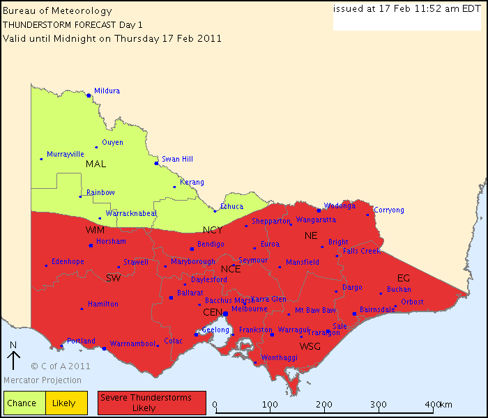
Australian Government Bureau of Meteorology
Victoria Regional Office
THUNDERSTORM FORECAST
Issued at 11:52 am Thursday, 17 February 2011,
Valid until midnight on Thursday, 17 February 2011.
Severe thunderstorms are likely to develop this afternoon/evening in the area shown, with flash flooding the most likely phenomena, however damaging winds and large hail are also a small risk. Thunderstorms are less likely in the northwest.
Former Owner - The Australian Weather Forum. Email me anytime - weatherman1000@hotmail.com
-
Supercellimpact

- Supercell
- Reactions:
- Posts: 1238
- Joined: Thu Oct 07, 2010 8:39 pm
- Location: Bendigo
Re: Victoria: A humid thundery week - 13th-20th Feb 2011
Some nice chunky clouds getting dark bases now, going by the radar theres a tiny bit of development to the south east of here.
Re: Victoria: A humid thundery week - 13th-20th Feb 2011
Holy hell that's an enthusiastic chart! I think that'd even top some of Jake's finest work.
In other news, here's some of that really low scud from last night that Rog mentioned earlier.

In other news, here's some of that really low scud from last night that Rog mentioned earlier.
-
Onetahuti

- Supercell
- Reactions:
- Posts: 2792
- Joined: Thu Mar 25, 2010 9:37 pm
- Location: Dandenong Nth.
Re: Victoria: A humid thundery week - 13th-20th Feb 2011
With humidity so high, I have 93% currently and the sun trying to break through to heat things up we could easily have a repeat of yesterday. Something we do not really need barring the statistical side of the event in adding to the months accumalative rainfall.
I note that Scoresby AWS has already broken its February rainfall record of 188 mm set in 2005, now sitting at 190.4 mm
I note that Scoresby AWS has already broken its February rainfall record of 188 mm set in 2005, now sitting at 190.4 mm
-
Rivergirl

- Memorial
- Reactions:
- Posts: 3674
- Joined: Sun Nov 22, 2009 6:04 pm
- Location: Ferny Creek VIC
- Contact:
Re: Victoria: A humid thundery week - 13th-20th Feb 2011
Australian Government Bureau of Meteorology
Victoria Regional Office
TOP PRIORITY FOR IMMEDIATE BROADCAST
SEVERE THUNDERSTORM WARNING
for FLASH FLOODING
For people in the Central, East Gippsland, West and South Gippsland and parts of the South West, North Central and North East s.
Issued at 12:27 pm Thursday, 17 February 2011.
Severe thunderstorms are likely to produce very heavy rainfall and flash flooding in the warning area over the next several hours. Locations which may be affected include Warrnambool, Ballarat, Geelong, Melbourne, Traralgon and Bairnsdale.
The State Emergency Service advises that people should:
* keep away from creeks and drains.
* do not drive vehicles through flooded areas.
* stay indoors if possible.
* Avoid using the phone during the storm.
* if you are outside, avoid sheltering under trees
* listen to the radio for storm updates
* switch off your computer and electrical appliances
The next warning is due to be issued by 3:30 pm.
If severe thunderstorms develop in the Melbourne Area, a more detailed Severe Thunderstorm Warning will be issued to people in this area.
Warnings are also available through TV and Radio broadcasts, the Bureau's website at http://www.bom.gov.au" onclick="window.open(this.href);return false; or call 1300 659 217. The Bureau and State Emergency Service would appreciate warnings being broadcast regularly.
- norfolk
- Supercell
- Reactions:
- Posts: 2024
- Joined: Thu Nov 26, 2009 7:03 pm
- Location: Caroline Springs, western Melbourne
- Contact:
Re: Victoria: A humid thundery week - 13th-20th Feb 2011
Nice cell formed near Geelong and moving north east. I wonder if it will maintain intensity and hit us here in the north west, that missed out yesterday?
-
Petros

- Supercell
- Reactions:
- Posts: 2001
- Joined: Tue Dec 01, 2009 6:25 pm
- Location: Maffra, Gippsland, Vic
Re: Victoria: A humid thundery week - 13th-20th Feb 2011
Very nice and steady rain has set in here in Latrobe Valley (at work) - been at it for 40 minutes now. 
- Hamlan
- Storm Chaser
- Reactions:
- Posts: 449
- Joined: Tue Dec 22, 2009 11:05 pm
- Location: Northern suburbs
Re: Victoria: A humid thundery week - 13th-20th Feb 2011
Currently have a view of both the Geelong cells and also the Crib Point cells. The Geel cells sent up sufficient updrafts to develop a weak mid to high level anvil (which doesnt appear to be lasting) with new pulses building on the northern flank now. The Crib Point cell has had some phenomenal punching updrafts, true cauliflower type if you can imagine  and I can now see the dark lowered base directly below what was previously the main convective updraft.
Brad
Brad
Last edited by Hamlan on Thu Feb 17, 2011 12:53 pm, edited 1 time in total.
-
Karl Lijnders
- Tornadic Supercell
- Reactions:
- Posts: 5771
- Joined: Sun Nov 22, 2009 11:17 pm
- Location: Knoxfield, Victoria
Re: Victoria: A humid thundery week - 13th-20th Feb 2011
Some of the bigger cells that develop over the inland suburbs this afternoon will be the ones too watch as they ride into the ranges later on. Could be some nasty storms with large hail potential.
Former Owner - The Australian Weather Forum. Email me anytime - weatherman1000@hotmail.com
- MurrayRiver1712
- Cumulus
- Reactions:
- Posts: 61
- Joined: Sat Feb 05, 2011 10:18 am
- Location: Echuca
Re: Victoria: A humid thundery week - 13th-20th Feb 2011
Its very humid here in Echuca, dosn't feel like anything is brewing though, but plenty of dark clouds passing. Usually if something does start its later in the afternoon.
-
AUS_Twisted

- Storm Chaser
- Reactions:
- Posts: 652
- Joined: Wed Nov 25, 2009 6:15 pm
- Location: Dandenong North, Melb
Re: Victoria: A humid thundery week - 13th-20th Feb 2011
Few web cam frame grabs from a pulsing CG yesterday of the Mortlake cell, one of the frames in the video shows the step leader coming up from the ground.


-
Karl Lijnders
- Tornadic Supercell
- Reactions:
- Posts: 5771
- Joined: Sun Nov 22, 2009 11:17 pm
- Location: Knoxfield, Victoria
Re: Victoria: A humid thundery week - 13th-20th Feb 2011
I know it is SA weather but this gives an indication as to the rainfall potential this weekend....
IDS20368
AUSTRALIAN GOVERNMENT - BUREAU OF METEOROLOGY
SOUTH AUSTRALIA REGIONAL OFFICE
FLOOD WATCH
For the Eyre Peninsula, Yorke Peninsula, Central [including the Mount Lofty
Ranges], Murraylands and Upper South East districts.
Issued at 11:35 am on Thursday, 17 February 2011
Note: This Flood Watch is a "heads up" for possible future flooding and is NOT a
Flood Warning.
Synoptic Situation:
A upper trough will bring a rain band to agricultural areas during Friday. Local
heavy falls are possible under the rain band, particularly about the Mount Lofty
Ranges. The rain band will gradually weaken and clear later on Friday and into
Saturday morning.
Rainfall:
Forecast:
30-50mm over agricultural areas with local falls of 50-80 mm, more likely about
the Mount Lofty Ranges.
Former Owner - The Australian Weather Forum. Email me anytime - weatherman1000@hotmail.com
-
Mosaic

- Cumulus
- Reactions:
- Posts: 90
- Joined: Mon Nov 30, 2009 2:39 pm
- Location: Glen Waverley, Victoria
Re: Victoria: A humid thundery week - 13th-20th Feb 2011
Extraordinary steamy outside, plenty of sunshine, upto 27 degC. Accumulated 4 mm out of the cells before lunchtime, looking forward to some action, we missed it yesterday.
-
Karl Lijnders
- Tornadic Supercell
- Reactions:
- Posts: 5771
- Joined: Sun Nov 22, 2009 11:17 pm
- Location: Knoxfield, Victoria
Re: Victoria: A humid thundery week - 13th-20th Feb 2011
IDV65752
Australian Government Bureau of Meteorology
Victoria Regional Office
TOP PRIORITY FOR IMMEDIATE BROADCAST
SEVERE THUNDERSTORM WARNING - MELBOURNE AREA
for FLASH FLOODING
For people in parts of the
Geelong and Bellarine Peninsula,
Mornington Peninsula and
Outer East Local Warning Areas.
Issued at 12:33 pm Thursday, 17 February 2011.
The Bureau of Meteorology warns that, at 12:35 pm, severe thunderstorms were detected on weather radar near the area north of Pakenham, the area west of Lara, Corio and the area east of Rosebud. These thunderstorms are moving towards the northeast. They are forecast to affect Gembrook, Lara and Upper Pakenham by 1:05 pm and Tyabb, the area east of Mornington and the area west of Werribee by 1:35 pm.
Very heavy rainfall and flash flooding are likely.
Former Owner - The Australian Weather Forum. Email me anytime - weatherman1000@hotmail.com
Re: Victoria: A humid thundery week - 13th-20th Feb 2011
Hmm.. where to go and watch.. decisions decisions!
Re: Victoria: A humid thundery week - 13th-20th Feb 2011
Just had a fresh downpour, the kind where it gets extremely dark beforehand, and I can see how people got such amazing totals yesterday... Thick huge fat tropical raindrops. Hopefully the driveway holds up to whatever more is on the way!
-
Karl Lijnders
- Tornadic Supercell
- Reactions:
- Posts: 5771
- Joined: Sun Nov 22, 2009 11:17 pm
- Location: Knoxfield, Victoria
Re: Victoria: A humid thundery week - 13th-20th Feb 2011
You can follow the weather locally here on facebook - all you got to do is add me and sign up!!
http://www.facebook.com/#!/album.php?ai ... =688641646
Very nice structure around. Inland stuff going the next step.
I would be heading inland Ryan.
http://www.facebook.com/#!/album.php?ai ... =688641646
Very nice structure around. Inland stuff going the next step.
I would be heading inland Ryan.
Former Owner - The Australian Weather Forum. Email me anytime - weatherman1000@hotmail.com
- Jake Smethurst
- Supercell
- Reactions:
- Posts: 3583
- Joined: Mon Nov 23, 2009 8:49 pm
- Location: Cheltenham
Re: Victoria: A humid thundery week - 13th-20th Feb 2011
Plenty of shower and even some thunderstorm development across the state. BoM pretty much spot on with that Severe Thunderstorm Warning map, I would be watching those areas closely for any development on the southern convergence in particular, but also lingering along the trough system which is very slow moving ... in-fact its slower moving than predicted.
Interesting here locally with some fresh convection going up, similar looking as to yesterday. Will be worth a close eye as the afternoon progresses.
Interesting here locally with some fresh convection going up, similar looking as to yesterday. Will be worth a close eye as the afternoon progresses.
Jake - Senior AWF Forecaster
Feel free to send me a private message if you have any questions.
Feel free to send me a private message if you have any questions.