I missed the moon Lily. Sounds like it was a sight to see

Welcome New Members! We want to hear from you. Register, stop lurking and start posting!
Victoria: Strong Westerly Frontal Belt. Aug 22nd-28th 2010
-
Rivergirl

- Memorial
- Reactions:
- Posts: 3674
- Joined: Sun Nov 22, 2009 6:04 pm
- Location: Ferny Creek VIC
- Contact:
Re: Victoria: Strong Westerly Frontal Belt. August 22nd-?
nafets, I have lived in Ferny Creek in the Dandenongs for 25 years and have never seen that happen. The best snow we've had since I've been here was in 1986, it stayed on the ground for 3 days. Nothing has compared to that since. We have more worries with falling trees from high winds and being stressed out by the drought.
I missed the moon Lily. Sounds like it was a sight to see
I missed the moon Lily. Sounds like it was a sight to see
Re: Victoria: Strong Westerly Frontal Belt. August 22nd-?
Thats good to hear!Rivergirl wrote:nafets, I have lived in Ferny Creek in the Dandenongs for 25 years and have never seen that happen. The best snow we've had since I've been here was in 1986, it stayed on the ground for 3 days. Nothing has compared to that since. We have more worries with falling trees from high winds and being stressed out by the drought.
I missed the moon Lily. Sounds like it was a sight to see
Go the bombersss!
Re: Victoria: Strong Westerly Frontal Belt. August 22nd-?
AV, The average rainfall here is still between 600mm and 650mm. I know it still isn't as mush as you might receive but is still more than the SW'ern suburbs 
Go the bombersss!
Re: Victoria: Strong Westerly Frontal Belt. August 22nd-?
Hi Everyone,
I was living in Montrose in 1986 when it snowed there, about 200m elevation overnight, and again about 9am. I think it was 25th July 1986. I also remember the nylex clock said 2C at about midday that day. I do have a picture of Mt Dandenong covered in snow that morning, taken the Montrose roundabout. I should dig it out and scan it and if anyone is interested post it here.
Back to the local weather, in Balaclava, I have seen rainful measurements from Prahran, but not found any BOM webpage listing it.
Yesterday evening the hail was very loud with a clap of thunder, was great to hear and see. All this rain has made the rivers flow wonderfully, Keppel Falls on Lady Talbot Drive near Marysville are flowing great, well worth a look.
Darren
Rivergirl wrote:nafets, I have lived in Ferny Creek in the Dandenongs for 25 years and have never seen that happen. The best snow we've had since I've been here was in 1986, it stayed on the ground for 3 days. Nothing has compared to that since. We have more worries with falling trees from high winds and being stressed out by the drought.
I missed the moon Lily. Sounds like it was a sight to see
- Skywalker
- Supercell
- Reactions:
- Posts: 1875
- Joined: Sun Nov 29, 2009 10:03 am
- Location: Burnside Heights/Cowes (Home) & Sunshine West (Work)
Re: Victoria: Strong Westerly Frontal Belt. August 22nd-?
ahh memories Daz. I remember that day well, was in Grade 6 & woke up to snow falling in Epping! Couldn't believe it at the time. Such a long time ago now.
Have a feeling about that cloud mass racing up from the south west overnight. Should be a few mm for me here.
Have a feeling about that cloud mass racing up from the south west overnight. Should be a few mm for me here.
Caroline Springs, Melbourne's meteorological boredom zone.
-
Rivergirl
- Memorial
- Reactions:
- Posts: 3674
- Joined: Sun Nov 22, 2009 6:04 pm
- Location: Ferny Creek VIC
- Contact:
Re: Victoria: Strong Westerly Frontal Belt. August 22nd-?
Hi Darren,
Yes I still have a clipping from the local paper of Rostrevor in Sassafras covered in snow. Looks a sight with the snow covered tree ferns. Also heaps of photos of my garden but Mt Dandenong taken from Montrose would be wonderful to see if you get a chance to scan.
Robyn
Yes I still have a clipping from the local paper of Rostrevor in Sassafras covered in snow. Looks a sight with the snow covered tree ferns. Also heaps of photos of my garden but Mt Dandenong taken from Montrose would be wonderful to see if you get a chance to scan.
Robyn
-
Karl Lijnders

- Tornadic Supercell
- Reactions:
- Posts: 5771
- Joined: Sun Nov 22, 2009 11:17 pm
- Location: Knoxfield, Victoria
Re: Victoria: Strong Westerly Frontal Belt. August 22nd-?
Looking pretty much dry for the Melbourne areas the winds are NW in a WSW flow so the falls will be light. Rain will increase in the morning with that warm front  moving in.
Former Owner - The Australian Weather Forum. Email me anytime - weatherman1000@hotmail.com
- droughtbreaker
- Supercell
- Reactions:
- Posts: 2844
- Joined: Wed Nov 25, 2009 7:50 pm
- Location: Mount Macedon, VIC, 520m asl
Re: Victoria: Strong Westerly Frontal Belt. August 22nd-?
I have photos from here in the 1986 event, really thick winter wonderland stuff. June (or July I've forgotten when exactly) 1995 was probably better though when we had thick snow down to about 450m here and it hung around for a couple of days.
-
Karl Lijnders
- Tornadic Supercell
- Reactions:
- Posts: 5771
- Joined: Sun Nov 22, 2009 11:17 pm
- Location: Knoxfield, Victoria
Re: Victoria: Strong Westerly Frontal Belt. August 22nd-?
Melbourne Metropolitan Area Forecast
Issued at 4:20 pm EST on Wednesday 25 August 2010
for the period until midnight EST Wednesday 1 September 2010.
Forecast for the rest of Wednesday
Cloudy. Isolated showers and the chance of thunderstorms with hail. Winds west to northwesterly averaging up to 40 km/h, although stronger with showers and thunderstorms.
Forecast for Thursday
Cloudy. Scattered showers with possible hail. Winds west to northwesterly averaging up to 30 km/h.
Forecast for Friday
Cloudy. Scattered showers. Winds west to southwesterly averaging 10 to 20 km/h.
CityFew showers.Min7Max14
Forecast for Saturday
Cloudy. Isolated showers. Winds west to southwesterly averaging 10 to 20 km/h tending south to southwesterly around midday.
CityShower or two.Min8Max15
Forecast for Sunday
Areas of morning fog. Light winds.
CitySunny.Min6Max17Mostly sunny.
-----------------------------------------------------------------
State Forecast
IDV10310
Australian Government Bureau of Meteorology
Victoria
Victoria State Forecast
Issued at 4:30 pm EST on Wednesday 25 August 2010
for the period until midnight EST Sunday 29 August 2010.
Weather Situation
A series of cold fronts will affect Victoria today and Thursday while an intense low pressure system south of Tasmania will move steadily eastwards during the week. A high pressure system will drift across South Australia on Friday and move over Victoria during the weekend.
Forecast for the rest of Wednesday
Scattered showers, mainly on and south of the divide, with possible hail and thunderstorms in the west. Snow above 700 metres. Fresh west to northwesterly winds, stronger about the coast and ranges.
Forecast for Thursday
Scattered showers, falling as snow above 900 metres, rising to 1200 metres. Possible hail and thunderstorms near the coast. Cold and cloudy with moderate to fresh west to northwesterly winds tending southwesterly later in the west.
Forecast for Friday
Scattered showers on and south of the divide, with snow above 1200 metres. Isolated showers on the northern plains. Cold and mostly cloudy with fresh to strong southwesterly winds, easing later in the west.
Forecast for Saturday
Isolated showers although more widespread in southern and mountain districts, with snow above 1200 metres. Cool to cold and mainly cloudy with light to moderate southwesterly winds, fresh about the coast.
Forecast for Sunday
Isolated showers on and south of the ranges, falling as snow above 1300 metres. Cool with light to moderate southerly winds.
------------------------------------------------------------------------
I wonder which it will be as the BoM are hinting at fine over Melbourne and cold and cloudy everywhere else away from the 5km radius of the CBD.
Former Owner - The Australian Weather Forum. Email me anytime - weatherman1000@hotmail.com
-
Petros

- Supercell
- Reactions:
- Posts: 2001
- Joined: Tue Dec 01, 2009 6:25 pm
- Location: Maffra, Gippsland, Vic
Re: Victoria: Strong Westerly Frontal Belt. August 22nd-?
Have a look at the level difference in Lake Glenmaggie compared to this time last year.
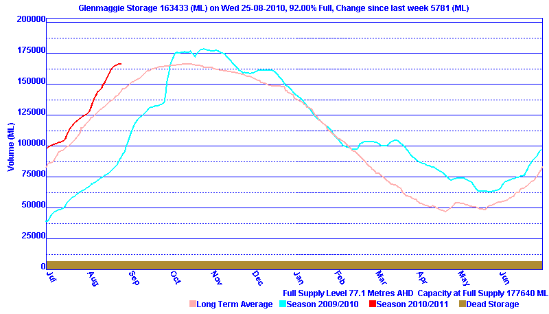
The rapid taper off over the last week is a combination of charging the McAllister (they've shut in the dam at Maffra) and filling the irrigation channels for the new season, plus a decent flow rate down river (through the Maffra weir) which I suspect is deliberate management of a surge buffer in Glenmaggie ahead of the melt and any possible pending rain event.
The rapid taper off over the last week is a combination of charging the McAllister (they've shut in the dam at Maffra) and filling the irrigation channels for the new season, plus a decent flow rate down river (through the Maffra weir) which I suspect is deliberate management of a surge buffer in Glenmaggie ahead of the melt and any possible pending rain event.
- Gordon
- Supercell
- Reactions:
- Posts: 2909
- Joined: Thu Jun 17, 2010 10:01 am
- Location: Near Gordon, Vic. 620 m asl
Re: Victoria: Strong Westerly Frontal Belt. August 22nd-?
Greatest destruction I've seen in the bush (besides fire) was due to heavy low level snow. Happened in the late 80s around Mt Buller (may have been that 1986 fall?) I intended to visit a friend at Howqua Hills a few days after the snowfall, but the Howqua Track was still closed by fallen trees, which took a week or more to clear. Below the 'regular' snowline for heavy snow (say, 700 metres or so) every second or third tree was either badly damaged or felled by the weight of the snow. On my friend's 5 acres (only 400 metres asl) a foot of snow fell and every gum or wattle lost branches or fell over. Only the European trees were unscathed. Same trip, I remember driving along the Buller Rd and there was still thick snow days later in the shaded sections along the Delatite near Sawmill Settlement.
Back on topic, 7 mm here today, taking us to 154 mm for August and thereby making this the wettest month in our 14 years here.
Back on topic, 7 mm here today, taking us to 154 mm for August and thereby making this the wettest month in our 14 years here.
Last edited by Gordon on Wed Aug 25, 2010 10:30 pm, edited 1 time in total.
- Twister
- Cumulonumbus Calvas
- Reactions:
- Posts: 914
- Joined: Sun Nov 29, 2009 10:47 pm
- Location: Brisbane Qld
Re: Victoria: Strong Westerly Frontal Belt. August 22nd-?
Well cant bash the Bom to much, there isolated shower forecast was bang on for tonight only few showers about thats it and dieing away.
Yeah that cloud rocketing up from the SW is quite interesting surely be some rain from that but looks like a huge area of mid and low level cloud maybe the warm air wrapped underneath the high then shot NE toward us moving at rapid pace might be all gone by morning its moving that fast
7c and cold atm with light W wind
Now Living in Wet QLD
-
Karl Lijnders
- Tornadic Supercell
- Reactions:
- Posts: 5771
- Joined: Sun Nov 22, 2009 11:17 pm
- Location: Knoxfield, Victoria
Re: Victoria: Strong Westerly Frontal Belt. August 22nd-?
Not worried about tonight as it is too westerly. I will bash them over this constant 3 different forecasts for each link they have. Over it.
Finished with 3.6mm here which is not too bad given that things didn't quite go our way. Sitting on 27mm now for the event, wettest winter in years and should get another 10-20mm over the coming days as we go a little more SW.
US bang on the money tonight it seems, not bad for a model that has been bashed a bit by some.
Former Owner - The Australian Weather Forum. Email me anytime - weatherman1000@hotmail.com
-
Karl Lijnders
- Tornadic Supercell
- Reactions:
- Posts: 5771
- Joined: Sun Nov 22, 2009 11:17 pm
- Location: Knoxfield, Victoria
Re: Victoria: Strong Westerly Frontal Belt. August 22nd-?
Rain increasing in the SW and that should generally traverse the region overnight and tomorrow morning. We should see it here in Melbourne by 4am.
Former Owner - The Australian Weather Forum. Email me anytime - weatherman1000@hotmail.com
-
AUSSKY

- Storm Chaser
- Reactions:
- Posts: 538
- Joined: Wed Nov 25, 2009 11:59 pm
- Location: Trentham (700m ASL)
- Contact:
Re: Victoria: Strong Westerly Frontal Belt. August 22nd-?
Drove home over Mt Macedon tonight - around 6pm snow level was 900m (rang Steve King at the BoM and he was happy because it confirmed his obs according to data). Slushy, sleety stuff in Macedon township as well....curretnly 2.3C in Trentham and trying very hard to sleet (I call it 'thick rain')
Australian Sky & Weather (AUSSKY)
Victoria - The State of Drizzle & Occasional Tornadoes
(1999 -2016)
Victoria - The State of Drizzle & Occasional Tornadoes
(1999 -2016)
- Twister
- Cumulonumbus Calvas
- Reactions:
- Posts: 914
- Joined: Sun Nov 29, 2009 10:47 pm
- Location: Brisbane Qld
Re: Victoria: Strong Westerly Frontal Belt. August 22nd-?
Yeah that band is looking quite nice, looks like periods of light rain, drizzle across W SW Vic through much of the am hoping it makes it up here, will be our last chance tomorrow before dieing and warming into the weekend and early next week
Most of state should see another few mms tomorrow
Cloud band looks unreal and look how far it has traveled last 12 hours unreal
Most of state should see another few mms tomorrow
Cloud band looks unreal and look how far it has traveled last 12 hours unreal
Now Living in Wet QLD
- Nick Sykes
- Cumulonimbus
- Reactions:
- Posts: 353
- Joined: Wed Nov 25, 2009 6:16 pm
- Location: Gungahlin, ACT
Re: Victoria: Strong Westerly Frontal Belt. August 22nd-?
There is one brighter blob in the band on the sat pic which may line up the Central district, fingers crossed. Got an all nighter ahead of me getting an assignment done, so watching it come ashore will help keep me awake lol, oh and coffee.
Nick
Nick
- stevco123
- Supercell
- Reactions:
- Posts: 2944
- Joined: Sat Aug 07, 2010 7:42 pm
- Location: Cranbourne 78m asl
Re: Victoria: Strong Westerly Frontal Belt. August 22nd-?
I can't remember who mentioned it on here tonight, but someone said they had a photo from 1986 of Mt dandenong from Montrose. I would LOOOVVVVEEEEto see that photo. In fact, I would love to see pics of snow in Melbourne, and also hear of any reports as well from the past.
https://www.weatherlink.com/bulletin/53 ... 76dd68e8bc: for current weather updated every 2 minutes
-
daviescr

- Supercell
- Reactions:
- Posts: 1394
- Joined: Wed Dec 02, 2009 5:40 pm
- Location: Warranwood, Vic
Re: Victoria: Strong Westerly Frontal Belt. August 22nd-?
Great idea Steveco, I'll start another thread for snow pics...
- stevco123
- Supercell
- Reactions:
- Posts: 2944
- Joined: Sat Aug 07, 2010 7:42 pm
- Location: Cranbourne 78m asl
Re: Victoria: Strong Westerly Frontal Belt. August 22nd-?
That's a good idea. I tried that on Weatherzone (Am i allowed to say that? I dont know as im new), but there wasnt enough people on the forum. I can get a lot more pics and info if a thread was started on here. It would be really interesting. Can't wait for it.
https://www.weatherlink.com/bulletin/53 ... 76dd68e8bc: for current weather updated every 2 minutes