
Welcome New Members! We want to hear from you. Register, stop lurking and start posting!
Victoria: A humid thundery week - 13th-20th Feb 2011
-
Anthony Violi

- Supercell
- Reactions:
- Posts: 2652
- Joined: Mon Nov 23, 2009 9:03 pm
- Location: Lilydale
- Contact:
Re: Victoria: A humid thundery week - 13th-20th Feb 2011
77.4mm was the total, more of the same today. Models were useless as usual and as I said 2 days ago I didn't believe the 2mm Norwegian had, they failed to pick it well at all. Expect Saturday to upgrade as well, as I have been saying, widespread 25-50mm.
http://www.therealworldweatherforum.com" onclick="window.open(this.href);return false;
avweatherforecasts.com
avweatherforecasts.com
-
Karl Lijnders

- Tornadic Supercell
- Reactions:
- Posts: 5771
- Joined: Sun Nov 22, 2009 11:17 pm
- Location: Knoxfield, Victoria
Re: Victoria: A humid thundery week - 13th-20th Feb 2011
Had 63mm of rain here. If Norweigen was to take them in a grid format as it appears it does then the 3mm it had for me yesterday needs explaining if that is the case and if it is worthy to defend. Not one model had the rainfall suggested, not one, and that bodes a problem for a system like Forecast Explorer, but there is a thread for that in General Weather in model discussion.
Anyway, I think a few showers and storms over the northern and eastern suburbs clearing today. Should develop on our door step then clear away to the NE at this stage.
Weekend still holding promise.
Anyway, I think a few showers and storms over the northern and eastern suburbs clearing today. Should develop on our door step then clear away to the NE at this stage.
Weekend still holding promise.
Former Owner - The Australian Weather Forum. Email me anytime - weatherman1000@hotmail.com

Re: Victoria: A humid thundery week - 13th-20th Feb 2011
Not far behind you AV with 69mm last night. WOW 
That was easily the most torrential rain I have had in the last two years since living in Bayswater.
That was easily the most torrential rain I have had in the last two years since living in Bayswater.
-
flatcam
- Cumulonimbus
- Reactions:
- Posts: 182
- Joined: Wed Jan 05, 2011 8:16 pm
- Location: Craigieburn, Victoria
Re: Victoria: A humid thundery week - 13th-20th Feb 2011
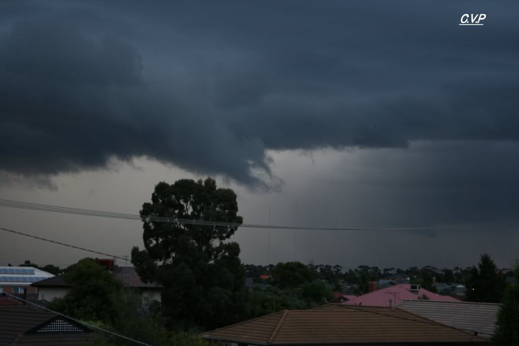
Guys, here are two more pics of the wall cloud and scud/funnel formation.
and
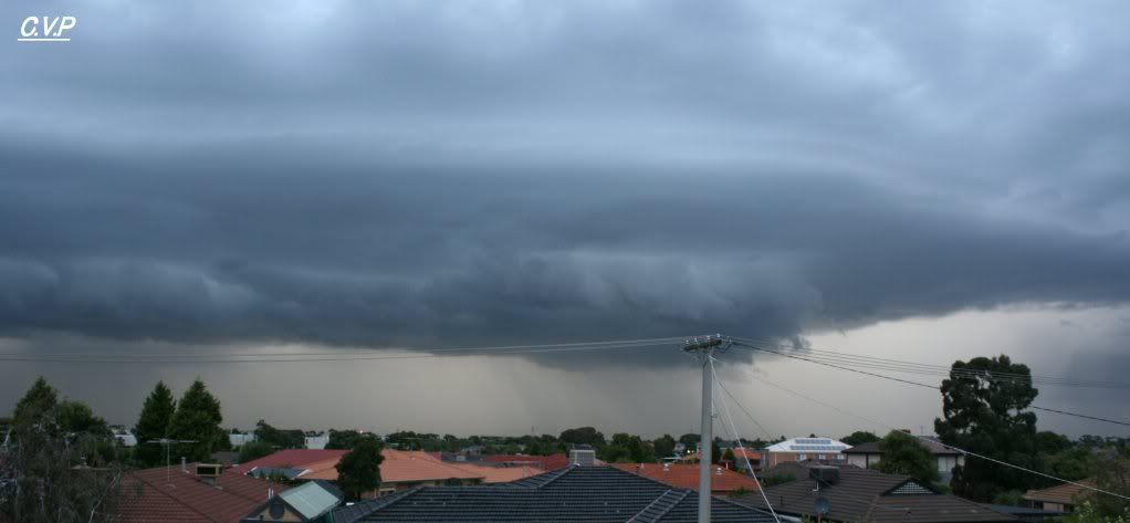
With the wall cloud, I couldn't find any pics of it as it developed with the wide angle view. I have one or two close ups though.
Cheers, Cam
and
With the wall cloud, I couldn't find any pics of it as it developed with the wide angle view. I have one or two close ups though.
Cheers, Cam
- Madmel
- Cumulonimbus
- Reactions:
- Posts: 182
- Joined: Thu Nov 26, 2009 3:19 pm
- Location: Tarneit & Williamstown Vic
Re: Victoria: A humid thundery week - 13th-20th Feb 2011
Not a bad drop since a few weeks ago. 20mm last night and was not expacting it at all.
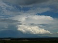
Cant really say much with this event cos nothing has really been happening this side of town apart from the humidity and watching the towers go up in the distance Great Show!
Cant really say much with this event cos nothing has really been happening this side of town apart from the humidity and watching the towers go up in the distance
-
Karl Lijnders
- Tornadic Supercell
- Reactions:
- Posts: 5771
- Joined: Sun Nov 22, 2009 11:17 pm
- Location: Knoxfield, Victoria
Re: Victoria: A humid thundery week - 13th-20th Feb 2011
Yeah nothing more than perhaps some inflow scud into the storm, or maybe it is a boundary between the NE winds and the S outflow. In any case, just scuddy cloud which indicates where the start of the rain is. Lovely pictures!!
Mel nice to see you getting in on some rainfall.
Showers becoming heavy here at work.
Mel nice to see you getting in on some rainfall.
Showers becoming heavy here at work.
Former Owner - The Australian Weather Forum. Email me anytime - weatherman1000@hotmail.com
-
Onetahuti

- Supercell
- Reactions:
- Posts: 2792
- Joined: Thu Mar 25, 2010 9:37 pm
- Location: Dandenong Nth.
Re: Victoria: A humid thundery week - 13th-20th Feb 2011
Light shower, 3mm so far this morning, 52mm in total
-
flatcam
- Cumulonimbus
- Reactions:
- Posts: 182
- Joined: Wed Jan 05, 2011 8:16 pm
- Location: Craigieburn, Victoria
Re: Victoria: A humid thundery week - 13th-20th Feb 2011
ThanksKarl Lijnders wrote:Yeah nothing more than perhaps some inflow scud into the storm, or maybe it is a boundary between the NE winds and the S outflow. In any case, just scuddy cloud which indicates where the start of the rain is. Lovely pictures!!
Mel nice to see you getting in on some rainfall.
Showers becoming heavy here at work.
Certainly was interesting to see it wrap. Would a funnel have a more tightly compacted shape? This formation seemed very 'loose', if you know what I mean.
Definitely a wall cloud though?
Cheers, Cam
-
Karl Lijnders
- Tornadic Supercell
- Reactions:
- Posts: 5771
- Joined: Sun Nov 22, 2009 11:17 pm
- Location: Knoxfield, Victoria
Re: Victoria: A humid thundery week - 13th-20th Feb 2011
Not a wall cloud mate, it appears to be a RFB (Rain Free Base) where the convection ahead of the storms rain core is developing due to strong outflow winds and this pushing the clouds infront of the rain up, giving you that distinctive black shelf of cloud. It is a fairly benign feature of these type of storms, but can throw out some lovely CGs before they unload they're precipitation.
Wall clouds are generally involved with much more mature storms. Yesterday was classic High Precipitation multicells.
Looking like the NW winds extend way back west DJ, so it could be a bit better today with storms firing off the SW coast even!
Wall clouds are generally involved with much more mature storms. Yesterday was classic High Precipitation multicells.
Looking like the NW winds extend way back west DJ, so it could be a bit better today with storms firing off the SW coast even!
Former Owner - The Australian Weather Forum. Email me anytime - weatherman1000@hotmail.com
-
flatcam
- Cumulonimbus
- Reactions:
- Posts: 182
- Joined: Wed Jan 05, 2011 8:16 pm
- Location: Craigieburn, Victoria
Re: Victoria: A humid thundery week - 13th-20th Feb 2011
Oh, okay. Unfortunately, this cell didn't produce any lightning that I saw, and I did not hear any thunder. Would have been great if it did - I could have gotten some lightning photos from my doorstep.Karl Lijnders wrote:Not a wall cloud mate, it appears to be a RFB (Rain Free Base) where the convection ahead of the storms rain core is developing due to strong outflow winds and this pushing the clouds infront of the rain up, giving you that distinctive black shelf of cloud. It is a fairly benign feature of these type of storms, but can throw out some lovely CGs before they unload they're precipitation.
Wall clouds are generally involved with much more mature storms. Yesterday was classic High Precipitation multicells.
Looking like the NW winds extend way back west DJ, so it could be a bit better today with storms firing off the SW coast even!
Hoping for some more storms soon. We still haven't been hit by one this year I think!
Cheers, Cam
-
Karl Lijnders
- Tornadic Supercell
- Reactions:
- Posts: 5771
- Joined: Sun Nov 22, 2009 11:17 pm
- Location: Knoxfield, Victoria
Re: Victoria: A humid thundery week - 13th-20th Feb 2011
More Storms to Batter VIC today.
http://www.abc.net.au
More storms are expected in Victoria today after a deluge last night caused flash flooding in some areas.
The rain caused flash flooding, power outages, and disruptions to some train services in Melbourne's east, but there were no reports of major damage.
Motorists had to be rescued from their swamped cars, and power was cut in some parts of Melbourne.
There were also major delays on the Cranbourne and Pakenham train lines.
About 60 millimetres of rain fell in parts of Melbourne's east, and 40mm at Mortlake in the western district.
About 50mm of rain fell at Scoresby and more than 60mm at Lilydale.
The Bureau of Meteorology's Terry Ryan says there will be more rain today.
"I think Melbourne mightn't get as much today, with most activity taking place about the ranges," he said.
"But there still is a good chance of some form of showers or thunderstorm activity either later morning or ... through the afternoon."
- ABC
© ABC 2010
----------------------------------
Interesting in a cross to the ABC radio yesterday the BoM advised not much rainfall around yesterday and they have said the same for today....maybe they have now cursed today and brought us more rain!!!
Former Owner - The Australian Weather Forum. Email me anytime - weatherman1000@hotmail.com
- norwester
- Cumulonimbus
- Reactions:
- Posts: 105
- Joined: Sat Feb 05, 2011 9:54 am
- Location: Merbein, Vic
Re: Victoria: A humid thundery week - 13th-20th Feb 2011
we have an amazingly thick blanket of fog everywhere this morning. Forecast is for a sunny day but rather hard to tell, even at 9.30am!
Dry, dusty and hot - usually!
- Claude Cat
- New User
- Reactions:
- Posts: 9
- Joined: Sun Mar 07, 2010 5:47 pm
- Location: Canterbury
Re: Victoria: A humid thundery week - 13th-20th Feb 2011
20mm from last night's activities in Canterbury.
-
Instability

- Cumulonimbus
- Reactions:
- Posts: 290
- Joined: Thu Nov 26, 2009 6:26 am
- Location: Live in Burwood - Work in Dandenong South
Re: Victoria: A humid thundery week - 13th-20th Feb 2011
I picked up 14.5mm overnight, taking me to 159.5 MTD and 259.7 YTD. My YTD total is already 30% of what I got for 2010, and 2010 was a pretty wet year! More impressive though is the total rainfall that I have had since the 6th of October 2010, coming in at 673.2mm (I am sure some have had much more than this). Over the last 134 days since the 6th of October that is an average rainfall of 5.02mm per day
I agree with your assessment too Karl re the low cloud that was photographed and mentioned. With such massive amounts of concentrated rain falling in small pockets on the eastern side of the convergence, it set the environment up beautifully for scud formation under the RFB to the west (possibly southwest) of the outflow. Some of it was forming, I would estimate, at or below 200m MSL, which looks spectacular but (as you mentioned) is pretty benign. I did not witness any rotation or lowering from my vantage point, but can undersstand confusion, as the scud was gathering and condensing so quickly and low to the ground that if you did not see the whole cycle it would appear to possibly be a lowering or wall cloud formation.
Rog.
P.S. I am so sick of mowing my lawn this summer!!! it just keeps growing and growing due to the rain / sun / rain / sun / etc.!!
-
daviescr

- Supercell
- Reactions:
- Posts: 1394
- Joined: Wed Dec 02, 2009 5:40 pm
- Location: Warranwood, Vic
Re: Victoria: A humid thundery week - 13th-20th Feb 2011
Incredible how only a few k's can make such a difference - i made it to 27.5mm, yet AV gets another 50mm. takes me to whopping 147mm for the month so far, with still more to go...
-
stratospear

- Supercell
- Reactions:
- Posts: 1261
- Joined: Sat Dec 19, 2009 9:38 am
- Location: Usually Bendigo
Re: Victoria: A humid thundery week - 13th-20th Feb 2011
I'm scratching my head at the differences between each of the main forecast models atm for next 3 days. For Bendigo: GFS has 80mm, EC - 25mm, BOM - 30mm, BOM (OCF) - 20mm. GFS is definitely the outlier, but it might be onto something given its recent record. A fair chunk of cloud over southern WA heading this way.
I think the positioning of the complex low that's forecast to form on Saturday morning over Vic is going to be influential on what we get.
I think the positioning of the complex low that's forecast to form on Saturday morning over Vic is going to be influential on what we get.
- Monbulkian
- Cumulonimbus
- Reactions:
- Posts: 192
- Joined: Thu Nov 11, 2010 9:42 pm
- Location: Monbulk
Re: Victoria: A humid thundery week - 13th-20th Feb 2011
Was sent outside by my husband to photograph an interesting black cloud heading our way. Where i am situated does not give me a great view of what is heading our way. Heard lots of thunder and saw some lightning strikes but we didn't get to much rain from the event early yesterday evening.HarleyB wrote:Wow! Monbulkian must be having a ball right about now!!
Had to play basketball in upwey and there seemed to be more rain in Kallista, Belgrave and Tecoma than we had at home. I have read through 12 pages in this thread and from what I have read I can assume that Knoxfield, FTG etc and from the other side Mt Evelyn and Lilydale seemed to cop the brunt of the storms and we missed it.
However until 9am this morning we have had 17.5mm. 4mm of that fell bwn 8:45 am and around 9:00 but I was doing the school run.
MTD: 191.5mm
YTD:284.5mm
- Skywalker
- Supercell
- Reactions:
- Posts: 1876
- Joined: Sun Nov 29, 2009 10:03 am
- Location: Burnside Heights/Cowes (Home) & Sunshine West (Work)
Re: Victoria: A humid thundery week - 13th-20th Feb 2011
It certainly is amazing how a few km's can make such a difference, have a look at my side of town. Madmel reported 20mm at Tarneit, Laverton recorded 16.8mm, yet the most I got was 2 brief showers that gave me a total of 2mm!daviescr wrote:Incredible how only a few k's can make such a difference - i made it to 27.5mm, yet AV gets another 50mm. takes me to whopping 147mm for the month so far, with still more to go...
It's been a very frustrating storm season for Caroline Springs, we have certainly had our share of rain events here but have missed every single decent storm to date.
Caroline Springs, Melbourne's meteorological boredom zone.
Re: Victoria: A humid thundery week - 13th-20th Feb 2011
Why us, Have got a small cell going every which way but loose and despite a STW for down here, it's hardly that at all, just a bit of rain and thunder.
Oh well, it had to be my turn someday.
Oh well, it had to be my turn someday.
- Claude Cat
- New User
- Reactions:
- Posts: 9
- Joined: Sun Mar 07, 2010 5:47 pm
- Location: Canterbury
Re: Victoria: A humid thundery week - 13th-20th Feb 2011
9am GFS has further upgraded rainfall through till Sunday.
