Page 14 of 21
Re: Victoria: Strong Westerly Frontal Belt. August 22nd-?
Posted: Wed Aug 25, 2010 4:42 pm
by stevco123
Latest bureau forecast for tonight is for isolated showers only with possible hail and thunder. Isolated??? have they seen the radar?
Re: Victoria: Strong Westerly Frontal Belt. August 22nd-?
Posted: Wed Aug 25, 2010 4:52 pm
by adon
Twister wrote:Lucky you adon, great month for you, what are you up to now, about 70mm for the month
Just missing EVERY shower today, going just north or south of here and only getting the side drizzle and light rain
Can see big CBs and Anvils to my SW S SE last few hours, they look great.
Once again many are getting more good rain today, and some areas have 10-15mm totals in the SW and still raining with it all moving E NE
Hoping for more later today looking black to my W SW once again
Next front racing up behind this one WELL south of SA more to come bring on all the rain
12c gusty N winds
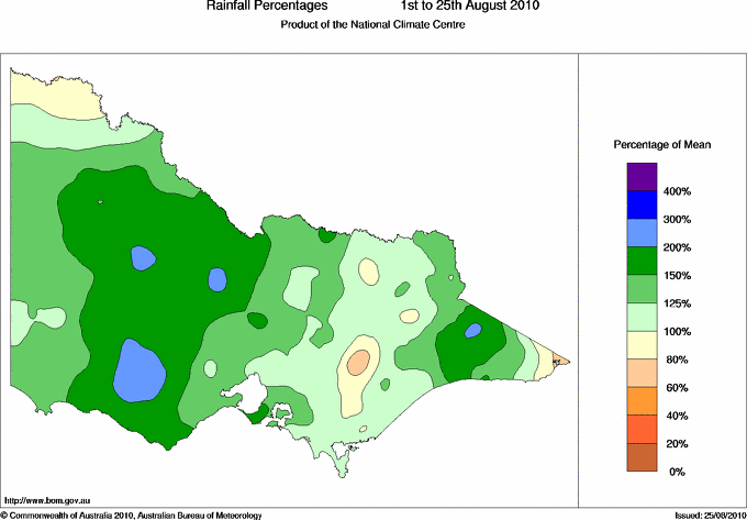
Would be closing in on 80-85mm for the month Twister. Water everywhere now and stories of people getting bogged everywhere now! Dunno what the record is but geez this is the wettest I remember and as I type it's pouring again!
Re: Victoria: Strong Westerly Frontal Belt. August 22nd-?
Posted: Wed Aug 25, 2010 5:03 pm
by Jake Smethurst
We have to remember that that forecast is for the Metropolitan region of Melbourne, or the CBD. But I agree, it's not isolated.

Showers all afternoon, some very heavy not reflective on radar for where we are. Winds become very strong too just before school finished. It's been raining since. Very nice. And we had 13mm to 9am this morning.
Would not be surprised to see a few embedded thunderstorms develop south/southeast of Echuca soon. Otherwise thunderstorms remain mostly possible in the southwest and about the coast.
Just had a close CG with amazing thunder!!

Re: Victoria: Strong Westerly Frontal Belt. August 22nd-?
Posted: Wed Aug 25, 2010 5:13 pm
by Duckey
Hi All!
Lightning showing up on the radar now around Birchip, hopefully will get some more firing up around the Eastern 'burbs later this evening. Was absolutely freezing today, wind chill factor must have been close to zero. Can any of our Mt Dandy residents tell me if there were any flurries up on the mountain today?

Re: Victoria: Strong Westerly Frontal Belt. August 22nd-?
Posted: Wed Aug 25, 2010 5:23 pm
by adon
Up to 10mm now so double what the forecast was. VERY good sign IMO. We seem to be getting at least the forecast and some times more than forecast. Last decade we have been getting a quarter of the forecast.
Re: Victoria: Strong Westerly Frontal Belt. August 22nd-?
Posted: Wed Aug 25, 2010 5:26 pm
by Macedonian
Hey towering updraft, snow falling thiis afternoon at mount macedon, looking over that way now i would say that it would probably still be snowing, it is absolutely filthy out there! Hoping for a settled fall in the morning.
Re: Victoria: Strong Westerly Frontal Belt. August 22nd-?
Posted: Wed Aug 25, 2010 5:34 pm
by droughtbreaker
Looks like a classic NW rain shadow going by GFS. 10mm+ down to around my place but then drops away to next to nothing by the time you get to Melbourne. Can't really see the temperature getting that low tonight but I was wrong about last night (although clear skies and dry air must have played a part). Had an unusual situation this morning, clear skies, a bit windy, 0.9C and the car iced over. Soon after that a little bit of drizzle started with the temp still around 1C.
0.9C to 5.5C temp range here today.
Re: Victoria: Strong Westerly Frontal Belt. August 22nd-?
Posted: Wed Aug 25, 2010 5:35 pm
by Karl Lijnders
US has an appalling track record of late so wouldn't read to much into it. Norweigen had 16mm here last night and has 0mm for tonight but it is raining already again! So the models are basically useless at the moment.
Just have to watch the radar.
Re: Victoria: Strong Westerly Frontal Belt. August 22nd-?
Posted: Wed Aug 25, 2010 5:36 pm
by Harley34
Can just make out the Squall line emerging from the SW near the Otways

, however the quality is poor as the line is currently in the hole..
Can anyone please explain why the line last night suddenly intensified, as it past the inner/eastern suburbs of Melbourne?
Re: Victoria: Strong Westerly Frontal Belt. August 22nd-?
Posted: Wed Aug 25, 2010 5:42 pm
by Duckey
Light rain just starting here now, the winds aren't as strong as earlier in the day but still very fresh
Re: Victoria: Strong Westerly Frontal Belt. August 22nd-?
Posted: Wed Aug 25, 2010 5:45 pm
by Petros
Baro has dropped from 1001 to 998 hPa and we have a very cold and gusty westerly happening outside. Got 3mm in the squally front last night and a 5 - 15C day here.
BOM 3 day chart shows us getting no rain here tonight so thats a bummer.
Re: Victoria: Strong Westerly Frontal Belt. August 22nd-?
Posted: Wed Aug 25, 2010 5:46 pm
by droughtbreaker
droughtbreaker wrote:Looks like a classic NW rain shadow going by GFS. 10mm+ down to around my place but then drops away to next to nothing by the time you get to Melbourne. Can't really see the temperature getting that low tonight but I was wrong about last night (although clear skies and dry air must have played a part).
Hadn't realised I'd already had 6.2mm for the day, so probably only about 5mm more in it. All the rain has been on and north of the ranges today with a strong rainshadow. Not sure if that will be the case tonight though, if an organised line comes through they tend to affect areas more south of the ranges.
Re: Victoria: Strong Westerly Frontal Belt. August 22nd-?
Posted: Wed Aug 25, 2010 5:48 pm
by Twister
Got smashed by a coldie more like a Summer storm than coldie had unreal anvil and billowing updraft was very impressive i must say really looked like spring storm.
Very heavy rain and hail, with hail roar was great to see am so happy and hopefully a few more mms with that last line to my west
3mm in 2 mins from the very small local shower
Once again many 5-15mm falls right across the state moving into central and E areas tonight
Re: Victoria: Strong Westerly Frontal Belt. August 22nd-?
Posted: Wed Aug 25, 2010 5:50 pm
by Karl Lijnders
Nice to hear you copping a smack there Dean!!
Rain increasing here in the east but not much wind at the moment. Nice wet August continues.

Re: Victoria: Strong Westerly Frontal Belt. August 22nd-?
Posted: Wed Aug 25, 2010 5:51 pm
by typhoon29
very very cold here today! Oh so close to snow I reckon, constant medium to light rain through out today (No hail!

), rather windy. At the moment the wind and rain has died right off. This morning we had a severe frost with fog, -2, black ice and a few prangs!Another frost tonight and more black ice.
Re: Victoria: Strong Westerly Frontal Belt. August 22nd-?
Posted: Wed Aug 25, 2010 5:51 pm
by Rivergirl
Hey Duckey

Hasn't been any snow or sleet here in Ferny Creek today, don't know about Mt Dandenong tho, probably not.
Re: Victoria: Strong Westerly Frontal Belt. August 22nd-?
Posted: Wed Aug 25, 2010 5:55 pm
by Duckey
Rivergirl wrote:Hey Duckey

Hasn't been any snow or sleet here in Ferny Creek today, don't know about Mt Dandenong tho, probably not.
Thanks Rivergirl, must have been close though. It's been such a lovely wet rainy cold winter, I'd love to see some snow up there before spring!
Re: Victoria: Strong Westerly Frontal Belt. August 22nd-?
Posted: Wed Aug 25, 2010 5:59 pm
by nafets
Harley34 wrote:Can anyone please explain why the line last night suddenly intensified, as it past the inner/eastern suburbs of Melbourne?
Im not 100% sure why, im also not 100% correct, so if im totally wrong someone please butt in

! I think as the CBD is a great example of a UHI, the heat remaining from the day that was trapped in the concrete jungle lifted (warm rising air) collided with the incoming showers to become heavier. Yet again im not sure as it was dark by the time the showers hit.

EDIT: does anyone think there will be a squall line? if so what time do you thing it would hit? Also to AV, would you classify John and i apart of the CBDesert?


Re: Victoria: Strong Westerly Frontal Belt. August 22nd-?
Posted: Wed Aug 25, 2010 6:01 pm
by Karl Lijnders
BTW Wislons Prom had another 42mm overnight and Weeoporinah had 27mm as well bringing them close to 500mm for the month!!
The rain tends to develop better over the eastern suburbs with the friction of the topography, the rise and fall of the land almost shakes the clouds a little and gives rainfall a better opportunity to fall. Out here we certainly are seeing that affect tonight.
Re: Victoria: Strong Westerly Frontal Belt. August 22nd-?
Posted: Wed Aug 25, 2010 6:07 pm
by typhoon29
raining steady again. Only 5mm so far today.......burrr still damn cold!

Hasn't been any snow or sleet here in Ferny Creek today, don't know about Mt Dandenong tho, probably not.