Hello all,
We are too far north (and west) for this event. Just 9mm, still a handy little total as I was only expecting 5-15mm, so right in the middle of that.

Welcome New Members! We want to hear from you. Register, stop lurking and start posting!
Victoria: Cold fronts & cut-off low - 17-20th Dec (Obs)
-
Karl Lijnders

- Tornadic Supercell
- Reactions:
- Posts: 5771
- Joined: Sun Nov 22, 2009 11:17 pm
- Location: Knoxfield, Victoria
Re: Victoria: Cold fronts & cut-off low - 17-20th Dec (Obs)
Sitting in torrential rain here still in Warranwood. Nearing 60mm and still coming down. 100mm might not be that unreal here this morning. Looking south towards TAS there is plenty more coming.
Flooding reports coming in from many places now around the east from Ringwood, Park Orchards, Knox and Glen Waverley. The Dandenongs have missed out on the bulk of it so far.
Flooding reports coming in from many places now around the east from Ringwood, Park Orchards, Knox and Glen Waverley. The Dandenongs have missed out on the bulk of it so far.
Former Owner - The Australian Weather Forum. Email me anytime - weatherman1000@hotmail.com
-
Instability

- Cumulonimbus
- Reactions:
- Posts: 290
- Joined: Thu Nov 26, 2009 6:26 am
- Location: Live in Burwood - Work in Dandenong South
Re: Victoria: Cold fronts & cut-off low - 17-20th Dec (Obs)
Just got home and still bucketing down outside. Appears we are sitting close to the firing line of this activity streaming in from the SSW.
Lots of flooded roads earlier today along Burwood HWY coming back from Knox City - although it always rains when I go out there
Lots of flooded roads earlier today along Burwood HWY coming back from Knox City - although it always rains when I go out there
-
Karl Lijnders
- Tornadic Supercell
- Reactions:
- Posts: 5771
- Joined: Sun Nov 22, 2009 11:17 pm
- Location: Knoxfield, Victoria
Re: Victoria: Cold fronts & cut-off low - 17-20th Dec (Obs)
Glad the tourist attraction is still being enjoyed by all out there!!
The rain is like a fog outside! Seriously, no weather model can pick this up...not even the new high tech stuff! Amazing!
Well as we are being taught a lesson by mother nature, the rain rates here are back towards 100mm/hr and wind kicked in a bit but briefly. 60.4mm here and rising!!!
The rain is like a fog outside! Seriously, no weather model can pick this up...not even the new high tech stuff! Amazing!
Well as we are being taught a lesson by mother nature, the rain rates here are back towards 100mm/hr and wind kicked in a bit but briefly. 60.4mm here and rising!!!
Former Owner - The Australian Weather Forum. Email me anytime - weatherman1000@hotmail.com
-
Tempest
- Cumulonimbus
- Reactions:
- Posts: 148
- Joined: Sat Aug 14, 2010 8:34 pm
- Location: Warragul North, Vic... 140m asl
Re: Victoria: Cold fronts & cut-off low - 17-20th Dec (Obs)
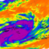
Yep! Even now it's still looking like everything is rotating around a point almost directly over the CBD yet the latest synoptics show the centre of the low well off the east coast nowPetros wrote: Can someone else also run the 24 Hr IR satloop....... am I wrong in thinking the centre of the low will be near Melb in an hour or so? Its supposed to be over N Tassie to move into Bass Straight before dipping to the SE during tomorrow morning. Not saying the models are wrong, just going by the IR evidence.
-
mad*moo73

- Cumulonumbus Calvas
- Reactions:
- Posts: 637
- Joined: Mon Mar 08, 2010 2:11 pm
- Location: Keysborough
Re: Victoria: Cold fronts & cut-off low - 17-20th Dec (Obs)
Absolutely belting down ATM!!!!!!!!!
Double Whopper award winning footy tipper!!!!!!!!!!!!!!
- SC.
- Cumulonimbus
- Reactions:
- Posts: 346
- Joined: Wed Nov 25, 2009 5:57 pm
- Location: Wheelers Hill
- Contact:
Re: Victoria: Cold fronts & cut-off low - 17-20th Dec (Obs)
Just heard a rumble. Crikey 60mm.
-
Karl Lijnders
- Tornadic Supercell
- Reactions:
- Posts: 5771
- Joined: Sun Nov 22, 2009 11:17 pm
- Location: Knoxfield, Victoria
Re: Victoria: Cold fronts & cut-off low - 17-20th Dec (Obs)
That rumble was a massive flang here!! My goodness!!!
66mm here and still coming down. Andersons Ck which is at the bottom of the street here will be over the road if this keeps going!!
66mm here and still coming down. Andersons Ck which is at the bottom of the street here will be over the road if this keeps going!!
Former Owner - The Australian Weather Forum. Email me anytime - weatherman1000@hotmail.com
- Lily
- Supercell
- Reactions:
- Posts: 4014
- Joined: Wed Nov 25, 2009 10:29 pm
- Location: Rowville/Lysterfield
Re: Victoria: Cold fronts & cut-off low - 17-20th Dec (Obs)
Good morning  Like you Stevco, we missed a fair portion of the action last night and only the edge of much of what passed over Melbourne and the inner suburbs. Not complaining though, since Friday, 51mm exactly here, yet Scoresby AWS has 49mm from yesterday alone so looks like we just missed much higher totals. Feels like winter this morning! No sign of the high winds that I was expecting here either, Petros. How are you guys faring down there this morning?
-
Karl Lijnders
- Tornadic Supercell
- Reactions:
- Posts: 5771
- Joined: Sun Nov 22, 2009 11:17 pm
- Location: Knoxfield, Victoria
Re: Victoria: Cold fronts & cut-off low - 17-20th Dec (Obs)
78mm here and still raining in Warranwood. Amazing!
Similar falls back home.
Street is a wash and plenty of very big puddles in the ditches around here.
Similar falls back home.
Street is a wash and plenty of very big puddles in the ditches around here.
Former Owner - The Australian Weather Forum. Email me anytime - weatherman1000@hotmail.com
- Proteous
- Cumulonimbus
- Reactions:
- Posts: 200
- Joined: Fri Nov 27, 2009 4:57 pm
- Location: Paynesville Gippsland Lakes.
Re: Victoria: Cold fronts & cut-off low - 17-20th Dec (Obs)
10.6mm here so far, mostly in thundery showers last evening. Cold with showers about this morning though the heaviest falls are a little further East of here. Westerly at 15 to 20 knots Temp. 10.3
-
Karl Lijnders
- Tornadic Supercell
- Reactions:
- Posts: 5771
- Joined: Sun Nov 22, 2009 11:17 pm
- Location: Knoxfield, Victoria
Re: Victoria: Cold fronts & cut-off low - 17-20th Dec (Obs)
I am sure DJ will have a list of rainfall totals longer than my arm.
Highest fall is Glen Waverley on 85mm and Springvale on 83mm. Still to check back at home but thinking between 70-80mm in Knox judging by the flooding in the area,
Still rain falling as well.
May see another 5-10mm before we clear.
Highest fall is Glen Waverley on 85mm and Springvale on 83mm. Still to check back at home but thinking between 70-80mm in Knox judging by the flooding in the area,
Still rain falling as well.
May see another 5-10mm before we clear.
Former Owner - The Australian Weather Forum. Email me anytime - weatherman1000@hotmail.com
-
Australis(Shell3155)

- Supercell
- Reactions:
- Posts: 3148
- Joined: Mon Nov 30, 2009 8:05 pm
- Location: FTG
- Contact:
Re: Victoria: Cold fronts & cut-off low - 17-20th Dec (Obs)
Mums heard on radio overnight,
5 homes Aspendale Gardens roofs exploded from Lightning strike.
about to google..
16mm friday
5m sat
woke to an extra 24mm overnight so 50.5 since 9am yesterday
71.5mm System.
152mm MTD
979mm Yr.
5 homes Aspendale Gardens roofs exploded from Lightning strike.
about to google..
16mm friday
5m sat
woke to an extra 24mm overnight so 50.5 since 9am yesterday
71.5mm System.
152mm MTD
979mm Yr.
-
Karl Lijnders
- Tornadic Supercell
- Reactions:
- Posts: 5771
- Joined: Sun Nov 22, 2009 11:17 pm
- Location: Knoxfield, Victoria
Re: Victoria: Cold fronts & cut-off low - 17-20th Dec (Obs)
DJ, I am sick of having this conversation with you everytime you get a lot less than everyone else.
I am staying at Chris Davies house in Warranwood, if you like you can take it up with him when you get back but he has had 78mm to 6am and 155mm MTD. I haven't returned home but I am sure I have got something fairly substantial.
David Brown announcing that the drought is over is music to my ears!!!
Oh and if you are referring to the rainfall in the Glen Waverley area then that was announced by the BoM on the ABC this morning at 655am. They said it fell within 4hrs.
I also watched the transformer explosion close to midnight from my perch in Warranwood over the Aspendale area.
Former Owner - The Australian Weather Forum. Email me anytime - weatherman1000@hotmail.com
-
Blackee

- Site Admin/Moderator
- Reactions:
- Posts: 3859
- Joined: Tue Nov 24, 2009 8:57 pm
- Location: Elwood and Mansfield 370m
Re: Victoria: Cold fronts & cut-off low - 17-20th Dec (Obs)
44mm here, which is between 4-5km from Chris Davies/Karls' 2nd place (as the crow flies).
We missed out big time early in the evening and then later in the event, but still jagged 44mm.
A couple of rolls of thunder gave the family a bit of a fright!
We missed out big time early in the evening and then later in the event, but still jagged 44mm.
A couple of rolls of thunder gave the family a bit of a fright!
Mansfield 370m and Elwood
-
Karl Lijnders
- Tornadic Supercell
- Reactions:
- Posts: 5771
- Joined: Sun Nov 22, 2009 11:17 pm
- Location: Knoxfield, Victoria
Re: Victoria: Cold fronts & cut-off low - 17-20th Dec (Obs)
Well if people go back over the radar, research the info on things a little better before coming out and claiming that people have quality control issues, it would be more useful. It is frustrating to people on here who constantly get shouted down at any given chance. It makes people not want to share information. It is wet blanket behaviour.
I he has a La Crosse Weather station, perched high above. I do not know the settings but it reads right. He got less last weekend, I got more, he got more this weekend and I probably got less back down here in Scoresby,
Radar reflects convergence, obvious convergence.
Maybe the houses loosing roofs didn't happen either...
Former Owner - The Australian Weather Forum. Email me anytime - weatherman1000@hotmail.com
-
Australis(Shell3155)
- Supercell
- Reactions:
- Posts: 3148
- Joined: Mon Nov 30, 2009 8:05 pm
- Location: FTG
- Contact:
Re: Victoria: Cold fronts & cut-off low - 17-20th Dec (Obs)
6 homes in one street has holes punched in their roofs,
I think the ses man mentioned 3 to 5 meter hole,
I just caught the end of the segment on the wireless.
think it was the 11pm cell. will be great to see some pics.
they did mention the street name, in one out the other.
I think the ses man mentioned 3 to 5 meter hole,
I just caught the end of the segment on the wireless.
think it was the 11pm cell. will be great to see some pics.
they did mention the street name, in one out the other.
-
Blackee
- Site Admin/Moderator
- Reactions:
- Posts: 3859
- Joined: Tue Nov 24, 2009 8:57 pm
- Location: Elwood and Mansfield 370m
Re: Victoria: Cold fronts & cut-off low - 17-20th Dec (Obs)
Melb 128km Radar sequence from early yesterday morning.
http://radar.strikeone.net.au/?fuseacti ... 1292790000" onclick="window.open(this.href);return false;
Bairnsdale 128km (requires alot of speeding up)
http://radar.strikeone.net.au/?fuseacti ... 1292790000" onclick="window.open(this.href);return false;
http://radar.strikeone.net.au/?fuseacti ... 1292790000" onclick="window.open(this.href);return false;
Bairnsdale 128km (requires alot of speeding up)
http://radar.strikeone.net.au/?fuseacti ... 1292790000" onclick="window.open(this.href);return false;
Mansfield 370m and Elwood
-
Onetahuti

- Supercell
- Reactions:
- Posts: 2792
- Joined: Thu Mar 25, 2010 9:37 pm
- Location: Dandenong Nth.
Re: Victoria: Cold fronts & cut-off low - 17-20th Dec (Obs)
Had 34.7mm in the manual guage, 38mm on the weather station since 9am yesterday, was sitting on about 15mm at nightfall.
-
Australis(Shell3155)
- Supercell
- Reactions:
- Posts: 3148
- Joined: Mon Nov 30, 2009 8:05 pm
- Location: FTG
- Contact:
Re: Victoria: Cold fronts & cut-off low - 17-20th Dec (Obs)
Scoresby sitting on 49.6mm
Mine AH 50.5mm
need the waders to check the manual gauge..
Mine AH 50.5mm
need the waders to check the manual gauge..