Page 2 of 2
Re: Summer 2016 /17 possible upcoming weather events
Posted: Sat Jan 21, 2017 3:26 pm
by Tassiedave
The heatwave looks well and truly on at the end of the month by the look of ACCESS.
Re: Summer 2016 /17 possible upcoming weather events
Posted: Sat Jan 21, 2017 5:59 pm
by JasmineStorm
Tassiedave wrote:The heatwave looks well and truly on at the end of the month by the look of ACCESS.
Certainly looking hot in the middle late next week. Depends I think on that monsoonal low starting to develop around the gulf and where it heads from there.
Re: Summer 2016 /17 possible upcoming weather events
Posted: Sat Jan 21, 2017 6:26 pm
by JasmineStorm
Another monsoon burst is now surging into the Australian tropics and models are becoming erratic again between runs. Level of confidence of anything past 4 days is low with this 3rd monsoon surge likely to trigger 1 or maybe 2 cyclones. The flow on affects for Victoria could be large between Jan 28th to Feb 10th. History suggests extreme weather events for Victoria associated with heat, storms or heavy rain are triggered once the monsoon is in full swing in early Feb.
Currently the monsoon trough is dipping and strengthening into northern Australia. Increased convection and strong westerlies can be seen on the current wind and cape map.
https://earth.nullschool.net/#current/w ... 81,-12.834
By next weekend, an inland heat bomb is lining up and there might be a strong north westerly at some point. GFS shows Saturday Jan 28th and EC shows Jan 30th for model run 21 Jan 00z
Re: Summer 2016 /17 possible upcoming weather events
Posted: Tue Jan 24, 2017 10:56 am
by JasmineStorm
This one is looking a little extreme at the moment for Monday across Vic – I'm using Access and EC as an example but all of the models a quite similar. Monsoon is off and running now, so anything is possible from this point. If the cyclone in the coral sea happens, I’m seeing an epic heat event for Northern Vic which will occasionally creep into the south with the northerly on certain days. Both Access and EC are showing high 40's above Victoria on Monday afternoon. EC's wind projection is a little worrying from a fire danger point of view as well.
Re: Summer 2016 /17 possible upcoming weather events
Posted: Tue Jan 24, 2017 11:30 am
by Geoff
I can't see anything to get excited about in those charts JS. Looks pretty standard summer fare to me, one hot day with temps in the low 40's in the Mallee and mid/high 30's in central Vic, with a decent cool change soon following. Doesn't look too windy either atm, though bear in mind it is still six days out and could end up completely different.
It's been a good summer here so far, let's hope it continues!

Re: Summer 2016 /17 possible upcoming weather events
Posted: Tue Jan 24, 2017 11:42 am
by StratoBendigo
Monday looks like a good chance of being our second day over 40 degC this summer. Fortunately it looks like a mild start to Feb 2017 (at least for the first few days).
Re: Summer 2016 /17 possible upcoming weather events
Posted: Tue Jan 24, 2017 12:25 pm
by JasmineStorm
Geoff wrote:I can't see anything to get excited about in those charts JS. Looks pretty standard summer fare to me, one hot day with temps in the low 40's in the Mallee and mid/high 30's in central Vic, with a decent cool change soon following. Doesn't look too windy either atm, though bear in mind it is still six days out and could end up completely different.
It's been a good summer here so far, let's hope it continues!
Yes Geoff, charts look quite standard-ish but watch for the impact of the monsoon the low's on this set up in the coming days

Re: Summer 2016 /17 possible upcoming weather events
Posted: Tue Jan 24, 2017 12:51 pm
by Tassiedave
I notice BOM has a forecast of 44 for Swan Hill on Monday.
Re: Summer 2016 /17 possible upcoming weather events
Posted: Tue Jan 24, 2017 4:40 pm
by hillybilly
850Ts look like being well into the mid 20s. That's potential runs towards 45C in the north. This used to be a rare event for Vic (will dig up some stats).
Thankfully, nice and green here ATM.
Re: Summer 2016 /17 possible upcoming weather events
Posted: Wed Jan 25, 2017 2:11 pm
by StratoBendigo
It's a long way out, but Access-G for 3rd Feb raises eyebrows. Yet another jet of tropical moisture from W.A which could dump a bit of rain (i.e. 20mm+) on parts of Vic again....
Re: Summer 2016 /17 possible upcoming weather events
Posted: Mon Jan 30, 2017 4:40 pm
by StratoBendigo
The odds of next week's rain event happening are firming up for us. EC still reckons 30mm+ and 00Z GFS is now on-board.
Some pretty big rain totals in parts of SW Western Australia last night and today...
Re: Summer 2016 /17 possible upcoming weather events
Posted: Fri Feb 03, 2017 10:36 am
by JasmineStorm
The Hadley cell is as far south as it gets. This is a serious area of heat in the middle of OZ next week, I can see why the BoM are thinking near 50c around Birdsville. One to watch here is if Victoria gets a north to north westerly feed from the terrestrial heat bomb, as there would be a large temp spike late next week if it does.
Re: Summer 2016 /17 possible upcoming weather events
Posted: Mon Feb 06, 2017 7:25 am
by Tassiedave
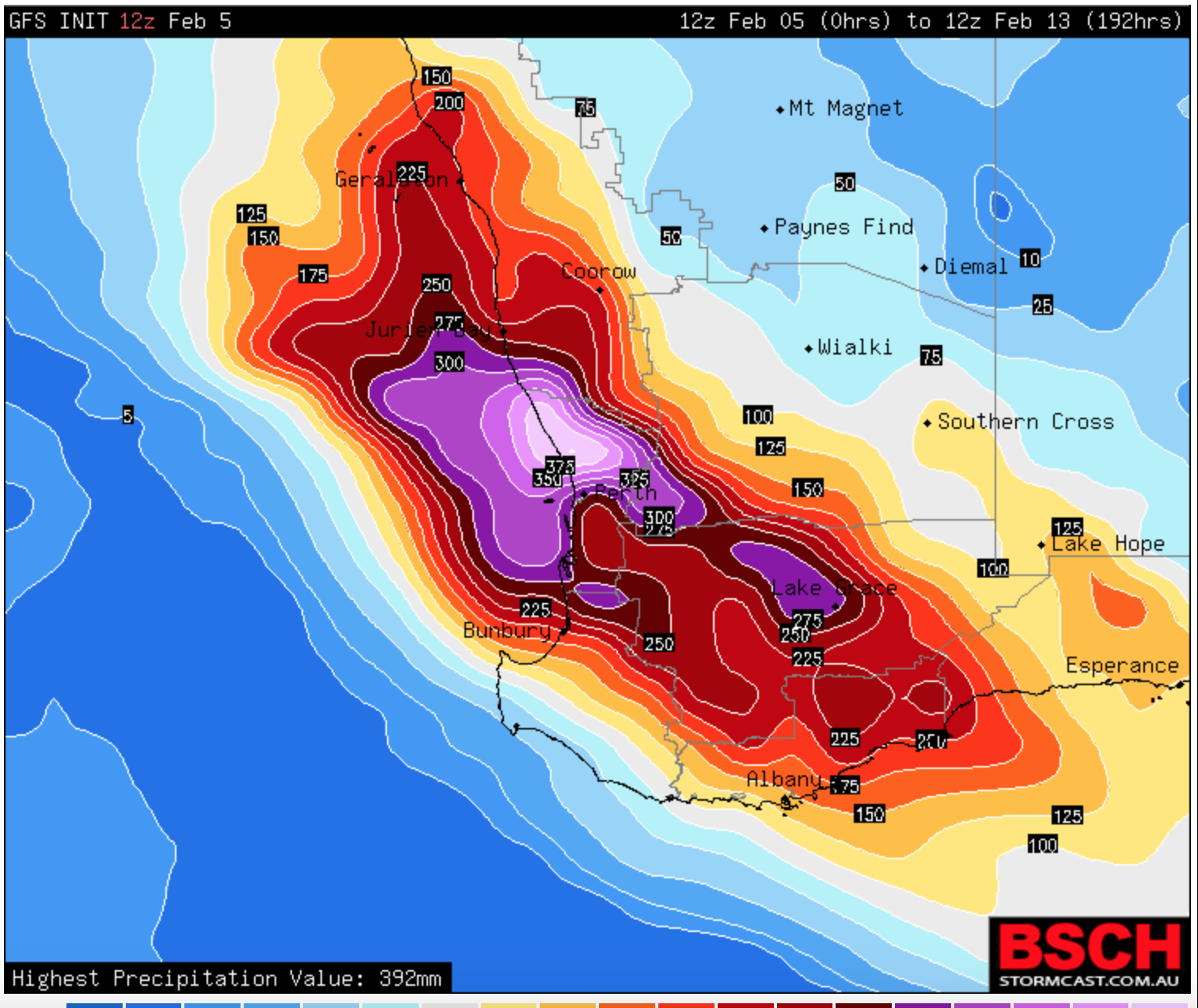
- Surely if this level of rain fell in Perth it would be one of the most incredible weather events in our nation's history!! How likely is it that this could occur?
- Screenshot 2017-02-06 07.18.55.png (422.17 KiB) Viewed 18548 times
Re: Summer 2016 /17 possible upcoming weather events
Posted: Mon Feb 06, 2017 8:59 pm
by JasmineStorm
Tassiedave wrote:Screenshot 2017-02-06 07.18.55.png
Definitely one to watch Tassie Dave.... I think we really won't know until that monsoonal low / possible cyclone shows it's cards. Cyclones are notorious for making mince meat of the forecast models, so I think once it's a predicable tropical despression or weaker low, confidence will be higher on the impact zone.
Re: Summer 2016 /17 possible upcoming weather events
Posted: Tue Feb 07, 2017 12:17 pm
by Tassiedave
A bit of to and fro from the models but Perth still in line for a record February downpour. Sydney just had 42mm in an hour, its volatile at the moment.
Re: Summer 2016 /17 possible upcoming weather events
Posted: Mon Feb 13, 2017 11:19 am
by JasmineStorm
A cold pulse from the roaring 40’s is stirring up the atmospheric pot according to most models early next week. GFS and EC have a cut off low nearby. CMC has it coming in on the Sunday on the last run. Then GFS has a solid heat wave coming in for the end of summer but this is still very early in the modelling and the monsoon lows could change and allow a southern front to slip through.
Re: Summer 2016 /17 possible upcoming weather events
Posted: Wed Feb 22, 2017 10:08 am
by JasmineStorm
GFS run Feb 21 18z has a March 1st unstable trough followed by a strong cold front on March 2nd that snaps into a deep spinning low on March 3rd around Bass strait, with a big south westerly influence into Melbourne. No other models have seen this scenario other than Access taking the front further south.
Re: Summer 2016 /17 possible upcoming weather events
Posted: Mon Mar 06, 2017 8:51 am
by Geoff
Latest model runs now seem to be favoring this dry blocking pattern to remain right into the last week of March. Could we be in for a completely dry month here? I've not recorded any measurable rain so far, yesterdays drizzly showers didn't register.

Re: Summer 2016 /17 possible upcoming weather events
Posted: Mon Mar 06, 2017 10:43 am
by JasmineStorm
Geoff wrote: ↑Mon Mar 06, 2017 8:51 am
Latest model runs now seem to be favoring this dry blocking pattern to remain right into the last week of March. Could we be in for a completely dry month here? I've not recorded any measurable rain so far, yesterdays drizzly showers didn't register.
Yes Geoff, it seems that way at the moment. Maybe there is a chance this weekend but at the moment the latest runs have it losing moisture as the low approaches Vic. It's hard to see it changing significantly anytime soon unless a big front can push its way up late next week.