Yes races at Flemington have been put back due to lightning. Pulse type storms and very slow moving, nothing here 34
/14.

Welcome New Members! We want to hear from you. Register, stop lurking and start posting!
Warm to hot and unstable: Feb 6 onwards
- I_Love_Storms
- Supercell
- Reactions:
- Posts: 2812
- Joined: Wed Dec 02, 2009 2:01 pm
- Location: Hawthorn
Re: Warm to hot and unstable: Feb 6 onwards
Becoming more widespread a STW for large parts of central
- BigBen
- Cumulonimbus
- Reactions:
- Posts: 135
- Joined: Tue Dec 08, 2009 10:16 am
- Location: Glen Huntly (home) Richmond (work)
Re: Warm to hot and unstable: Feb 6 onwards
Cell has formed just north of me in Sunshine, a few moments of heavy drops and a number of rumbles but it's moving away from me. Think it has a plane to catch at the airport.
- Skywalker
- Supercell
- Reactions:
- Posts: 1875
- Joined: Sun Nov 29, 2009 10:03 am
- Location: Burnside Heights/Cowes (Home) & Sunshine West (Work)
Re: Warm to hot and unstable: Feb 6 onwards
Have a perfect visual of that one, we are right on the edge of it.BigBen » Sat Feb 21, 2015 5:21 pm wrote:BigBen wrote:Cell has formed just north of me in Sunshine, a few moments of heavy drops and a number of rumbles but it's moving away from me. Think it has a plane to catch at the airport.
Just returned back from Kilmore and came back via Lancefield. Had an amazing view of the cells developing in all directions.
Caroline Springs, Melbourne's meteorological boredom zone.
- Jake Smethurst
- Supercell
- Reactions:
- Posts: 3583
- Joined: Mon Nov 23, 2009 8:49 pm
- Location: Cheltenham
Re: Warm to hot and unstable: Feb 6 onwards
These cells are very localised and slow-moving. They are decaying as quickly as they are developing. Anywhere in Melbourne is at risk this afternoon and evening, but will clear later. The storms in Melbourne and surrounds are capable of producing all of the severe phenomena, large hail, damaging winds and heavy rainfall, while the storms in the west of the state are more high-based so damaging winds the biggest threat in those. Likely to see a repeat of this tomorrow afternoon/evening.
Managed to see a heavy burst of rain here in Brighton for like 60 seconds, since then it's been dry. Haven't heard any thunder or seen any lightning, but have heard of reports of tree damage and power outages over northern Melbourne.
Managed to see a heavy burst of rain here in Brighton for like 60 seconds, since then it's been dry. Haven't heard any thunder or seen any lightning, but have heard of reports of tree damage and power outages over northern Melbourne.
Jake - Senior AWF Forecaster
Feel free to send me a private message if you have any questions.
Feel free to send me a private message if you have any questions.
- Dane
- Supercell
- Reactions:
- Posts: 1662
- Joined: Thu Nov 26, 2009 9:51 am
- Location: Sebastopol 420m ASL
- Contact:
Re: Warm to hot and unstable: Feb 6 onwards
North Wharf just West of the CBD has received 22mm's, City just 1.6mm's.
Nothing here and I doubt there will be.
Nothing here and I doubt there will be.
- Skywalker
- Supercell
- Reactions:
- Posts: 1875
- Joined: Sun Nov 29, 2009 10:03 am
- Location: Burnside Heights/Cowes (Home) & Sunshine West (Work)
Re: Warm to hot and unstable: Feb 6 onwards
Caroline Springs storm shield winning the battle here. Cell has drifted east away from us.
Caroline Springs, Melbourne's meteorological boredom zone.
- wolfcat
- Cumulonumbus Calvas
- Reactions:
- Posts: 562
- Joined: Sun Mar 07, 2010 12:14 pm
- Location: Bentleigh East
- Contact:
Re: Warm to hot and unstable: Feb 6 onwards
Brighton, this afternoon.

other places you will find me...
My blog...http://www.wolfcat.com.au/randomrants/
Flickr .. http://www.flickr.com/photos/wolfcat_aus/
Twitter... http://twitter.com/wolfcat
Redbubble... http://www.redbubble.com/people/wolfcat
My blog...http://www.wolfcat.com.au/randomrants/
Flickr .. http://www.flickr.com/photos/wolfcat_aus/
Twitter... http://twitter.com/wolfcat
Redbubble... http://www.redbubble.com/people/wolfcat
- Jake Smethurst
- Supercell
- Reactions:
- Posts: 3583
- Joined: Mon Nov 23, 2009 8:49 pm
- Location: Cheltenham
Re: Warm to hot and unstable: Feb 6 onwards
There's a large supercell thunderstorm north of Mt. Baw Baw. It's moving slowly north and is likely chucking out some impressive hail. I heard somewhere radar is suggesting up to 14cm, but probably not that big. Destructive winds and even tornadoes possible in that HP supercell.
Jake - Senior AWF Forecaster
Feel free to send me a private message if you have any questions.
Feel free to send me a private message if you have any questions.
- wolfcat
- Cumulonumbus Calvas
- Reactions:
- Posts: 562
- Joined: Sun Mar 07, 2010 12:14 pm
- Location: Bentleigh East
- Contact:
Re: Warm to hot and unstable: Feb 6 onwards
Timelapse of an hour at North Point this arvo.
[youtube]zmEhI13_tqs[/youtube]
[youtube]zmEhI13_tqs[/youtube]
other places you will find me...
My blog...http://www.wolfcat.com.au/randomrants/
Flickr .. http://www.flickr.com/photos/wolfcat_aus/
Twitter... http://twitter.com/wolfcat
Redbubble... http://www.redbubble.com/people/wolfcat
My blog...http://www.wolfcat.com.au/randomrants/
Flickr .. http://www.flickr.com/photos/wolfcat_aus/
Twitter... http://twitter.com/wolfcat
Redbubble... http://www.redbubble.com/people/wolfcat
-
typhoon29

- Cumulonumbus Calvas
- Reactions:
- Posts: 510
- Joined: Fri Jan 01, 2010 11:05 pm
- Location: Ballarat (Mitchell Park)
- Contact:
Re: Warm to hot and unstable: Feb 6 onwards
we won cricket easy today a rumble or two late in the game, storms appear to be decaying now, a few spits as they say nigh night, very stgrong out flow from a dying cell 20mins ago as it unloaded, few flangs to the south. Tmoz take two.
Ballarat, Home of the Anti-Thunderstorm Shield!
- Rhino
- Supercell
- Reactions:
- Posts: 1227
- Joined: Mon Nov 30, 2009 11:37 am
- Location: Carisbrook-Near Maryborough
Re: Warm to hot and unstable: Feb 6 onwards
Well here we go with this blasted interference again, really has been bad lately and when it occurs is shocking, would love to know what's causing it and perhaps so would the BOM  ......anyway still seems some decent showers around and may get a sprinkle here overnight but then again with this radar could be patches of goat moths or locusts or fruit bats.....who knows
  .
.
Rhino.
Rhino.
Re: Warm to hot and unstable: Feb 6 onwards
I think the tulla radar is better at the moment.
its also telling me I might get a bit wet soon!
its also telling me I might get a bit wet soon!
-
hillybilly

- Site Admin/Moderator
- Reactions:
- Posts: 5048
- Joined: Thu Nov 26, 2009 7:26 am
- Location: Howden Tasmania, 25m above sea level
- Contact:
Re: Warm to hot and unstable: Feb 6 onwards
About three spots up here from those cells. That's three more than I was expecting 
Hot one 33C which is about 38C at sea level. Was bricking and felt like 133C in the sun during the arvo
Today more or less looks like a repeat. Bit of instability in the mid levels. Yesterday's storms seemed to be getting a bit of kick out of the warm bay sea breeze. Will be really hit and miss again.
Tomorrow's front look a bit more widespread, but not a lot in it at this stage.
 The Melbourne Ap radar is on a hill so avoids this scenario in most cases.
Hot one 33C which is about 38C at sea level. Was bricking and felt like 133C in the sun during the arvo
Today more or less looks like a repeat. Bit of instability in the mid levels. Yesterday's storms seemed to be getting a bit of kick out of the warm bay sea breeze. Will be really hit and miss again.
Tomorrow's front look a bit more widespread, but not a lot in it at this stage.
Seems to be an inversion issue with these humid easterlies in the evening. The radar sits in a low point in a basin and if you have inversions then the radar beam can be bent back down and hit the ground. That's My guess anywayWell here we go with this blasted interference again, really has been bad lately and when it occurs is shocking,
-
mick

- Supercell
- Reactions:
- Posts: 1453
- Joined: Mon Nov 30, 2009 6:45 pm
- Location: Mid North SA Baaaaaaaaaaaaaaa
Re: Warm to hot and unstable: Feb 6 onwards
Very hot last night duh, clouded over atm, knocked 10 degrees off the feel instantly.
Hard to tell what will happen today, will everything burn off or will we get stormies? I dont think even the BOM knows.
36 should not be a problem culd be an ugly night, 30 at midnight scenario but some cooler winds to the west. Northerly only weak atm, the wind could be the key.
Hard to tell what will happen today, will everything burn off or will we get stormies? I dont think even the BOM knows.
36 should not be a problem culd be an ugly night, 30 at midnight scenario but some cooler winds to the west. Northerly only weak atm, the wind could be the key.
-
Rivergirl

- Memorial
- Reactions:
- Posts: 3674
- Joined: Sun Nov 22, 2009 6:04 pm
- Location: Ferny Creek VIC
- Contact:
Re: Warm to hot and unstable: Feb 6 onwards
Nice pic and video wolfcat
- Jake Smethurst
- Supercell
- Reactions:
- Posts: 3583
- Joined: Mon Nov 23, 2009 8:49 pm
- Location: Cheltenham
Re: Warm to hot and unstable: Feb 6 onwards
Expecting a general repeat to yesterday ... it sure is steamy out there! Some lightning reported earlier in the southwest and now again some recent development.
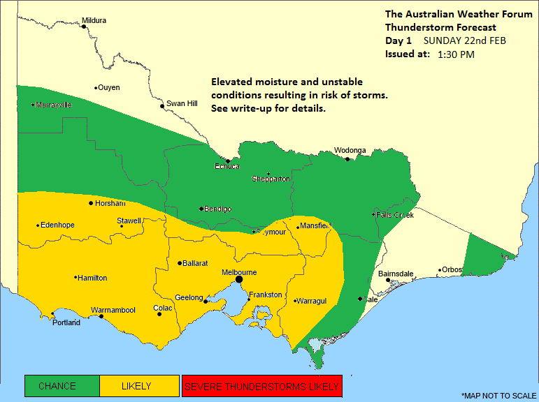
Here's our storm chart for today.
Thunderstorm Forecast - Day 1
Issued at 1:30pm Sunday 22nd February 2015
Discussion for Sunday
Elevated moisture levels and unstable conditions across Victoria may result in thunderstorm activity through parts of the state this afternoon and continuing into the evening. The most likely areas to see development is across the southwest district and central district. In the southwest a trough will extend into the region this afternoon, providing a focus for thunderstorms to initiate. In the central district, generally hot surface temperatures and unstable uppers should be enough to provide an appropriate lifting mechanism for isolated thunderstorm development, as well as local convergence zones being a focus. A chance for development exists through most remaining areas, except for the far northwest and parts of Gippsland where drier conditions are persisting and where there is a lack of a mechanism to activate convection. If thunderstorms develop, they are likely to be similar to yesterday; quick development and then quick decay, and quite local, so hit and miss variety type of activity. Nevertheless, severe thunderstorms are certainly a risk this afternoon and evening. Across central Victoria, all severe phenomena are possible, with the highest risks for heavy rainfall (due to slow movement) and damaging winds. In the west and southwest, the biggest severe risks will be damaging winds, while heavy rainfall is less likely, though cannot be ruled out entirely. Large hailstones will be possible in any severe thunderstorm that develops. It is also worth to note, that if cloud cover does not clear over any particular area, than that area will see a diminished risk of convective development.
Jake - Senior AWF Forecaster
Feel free to send me a private message if you have any questions.
Feel free to send me a private message if you have any questions.
- WeatherViewer
- Cumulonimbus
- Reactions:
- Posts: 389
- Joined: Fri Oct 19, 2012 5:57 pm
- Location: Truganina
Re: Warm to hot and unstable: Feb 6 onwards
While most of you may not believe it as there is no Official BOM site in this corner of the outer South West of Melbourne.
My gauge in the shade and the local trusted station getting close to 40c. Bloody hot out plenty of sun here in Wyndham Vale. Similar temps yesterday also, definitely a warmer pocket here in Summer.
Definitely hoping for some action later, we missed out on everything yesterday.
My gauge in the shade and the local trusted station getting close to 40c. Bloody hot out plenty of sun here in Wyndham Vale. Similar temps yesterday also, definitely a warmer pocket here in Summer.
Definitely hoping for some action later, we missed out on everything yesterday.
- Jake Smethurst
- Supercell
- Reactions:
- Posts: 3583
- Joined: Mon Nov 23, 2009 8:49 pm
- Location: Cheltenham
Re: Warm to hot and unstable: Feb 6 onwards
Thunderstorms popping up quite rapidly now through parts of the Southwest, Central and Gippsland districts. Some of them look severe too, storm near Werribee. Appears another thunderstorm trying to develop around Laverton way.
Jake - Senior AWF Forecaster
Feel free to send me a private message if you have any questions.
Feel free to send me a private message if you have any questions.
- WeatherViewer
- Cumulonimbus
- Reactions:
- Posts: 389
- Joined: Fri Oct 19, 2012 5:57 pm
- Location: Truganina
Re: Warm to hot and unstable: Feb 6 onwards
Dark clouds almost overhead. Very Thundery here in Wyndham Vale. Just saw a massive bolt hit the You Yang's in the distance.