Rhino.

Welcome New Members! We want to hear from you. Register, stop lurking and start posting!
Victoria: Low Pressure System Cup Weekend 2010
- Rhino
- Supercell
- Reactions:
- Posts: 1227
- Joined: Mon Nov 30, 2009 11:37 am
- Location: Carisbrook-Near Maryborough
Re: Victoria: Low Pressure System Cup Weekend 2010
EC going for 82mm here for the weekend, so has increased amount again from this mornings run, and generally 70-80mm for this general area so flooding on the cards and really don't want that amount, someone else can have it this time  . Only hope if that amount falls it does happen over the 2 days and not like the floods in Sep when I got 92mm in 15 hours. Can't wait to see the horses in the Cox plate breastroking their way up the straight. Anyway things could still change yet, although we're gunna get rain which ever way you look at it, and it is looking increasing like it's going to dump big time. POO STINK...
Rhino.
Rhino.
-
Petros

- Supercell
- Reactions:
- Posts: 2001
- Joined: Tue Dec 01, 2009 6:25 pm
- Location: Maffra, Gippsland, Vic
Re: Victoria: Low Pressure System Cup Weekend 2010
Geez Karl, good effort and (most of all) really hope you are right!!!!!Karl Lijnders wrote:Saturday: Rain areas and isolated thunderstorms over western and central areas will become more extensive and heavy during the afternoon with local flooding developing later. Scattered showers and thunderstorms in the east and northeast will tend to rain during the late afternoon with locally heavy falls and flash flooding developing during the evening or overnight. NNE winds over much of the state shifting SW/S over the western districts later. Mild and humid in C and E areas but becoming colder in the far west later.
Sunday: Heavy rain areas and local thunderstorms over C and E VIC will gradually ease from the NW during the day. Local flooding likely to continue. Showers over the remainder of W VIC with afternoon thunderstorms and hail likely. Becoming colder from the west with WNW winds developing throughout although NNE winds prevailing in the far east.
Monday: Showers, more isolated in the north will become more extensive during the afternoon over S VIC and tend to rain periods about S Gippsland and E Central areas later. Scattered afternoon thunderstorms over N VIC with possible hail. Snowfalls lowering to 1100m later. Cold with NW/W winds shifting SW later from the west.
Tuesday: Rain areas and isolated thunderstorms with hail in S and Mountain VIC will ease to showers from the west. Snow about Alpine areas. SW/S winds strong at first tending more SW later. Becoming fine over the NW with only isolated afternoon showers over the N plains. Cold throughout.
Twister - shared your concern over how moisture can advect in time for this system, but in hindsight we've had a persistant steady easterly wind here from dawn to dusk so this side of the state is at least clear of the sm air.
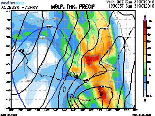
3 day BOM (AccessR - how come nobody seems to refer to it now that the system is on the doorstep?) shows this for Sunday...
A big weekend ahead and the SES will be busy in a few areas I reckon!
[edit] - (and maybe a bit too early to say this), but Karl has consistently stuck with this forecast over the past 3 days at least - despite the vacillating models. For me, I just love the way that GFS can predict a situation 8 days out, discount it later, then come back on track. Has happened for 3 major events this winter/spring. Not saying that we should bank on model progs out in "fairy land" - but it is well worth the effort to watch the actual system unfold. And in most events progged 6+ days lately, the "smoke/fire" theory isnt far wrong imo.
Last edited by Petros on Thu Oct 28, 2010 8:55 pm, edited 1 time in total.
Re: Victoria: Low Pressure System Cup Weekend 2010
as a keen weather follower and punter- just wondering when the heavy stuff will start? Will it hold off until mid-late afternoon sat? Could be a shocking day. So you think.
- Lily
- Supercell
- Reactions:
- Posts: 4014
- Joined: Wed Nov 25, 2009 10:29 pm
- Location: Rowville/Lysterfield
Re: Victoria: Low Pressure System Cup Weekend 2010
LOL!!!!chillout wrote:Could be a shocking day. So you think.
-
Petros
- Supercell
- Reactions:
- Posts: 2001
- Joined: Tue Dec 01, 2009 6:25 pm
- Location: Maffra, Gippsland, Vic
Re: Victoria: Low Pressure System Cup Weekend 2010
Thats it, I'm off to the TAB!!Lily wrote:LOL!!!!chillout wrote:Could be a shocking day. So you think.
- I_Love_Storms
- Supercell
- Reactions:
- Posts: 2812
- Joined: Wed Dec 02, 2009 2:01 pm
- Location: Hawthorn
Re: Victoria: Low Pressure System Cup Weekend 2010
Saturday afternoon now looks like the brunt of the storm, literally. Very possible that a very slow line of storms embedded in a rain band will move through central areas Saturday afternoon. I reckon this could dump localised falls of 30mm alone.
Overnight into Sunday and until around Sunday midday we will likely get very convective locally heavy rainfall with isolated storms as well.
At this stage we are looking at a general 30mm on Saturday and another 25mm on Sunday in central areas, pretty in-line with models. There will be isolated falls in Central areas (including Karl's house LOL) of around 50mm on Saturday and 35mm on Sunday.
Re: Victoria: Low Pressure System Cup Weekend 2010
Looking good. Was gunna go up to Eildon this week.
fortius quo fidelius
- droughtbreaker
- Supercell
- Reactions:
- Posts: 2844
- Joined: Wed Nov 25, 2009 7:50 pm
- Location: Mount Macedon, VIC, 520m asl
Re: Victoria: Low Pressure System Cup Weekend 2010
Looking like 50-100mm here taken from all the models averaged out. BOM 3 Day doesn't look right at all, it is an outlier atm and therefore can not be trusted.
EC has around 83mm here up to Cup day, GFS going for 75mm+ as well. We seem to be in the firing line here for some of the heaviest falls at this stage.
There will be no problems with moisture I can assure you, the northerlies with associated warm air advection and moisture infeed extends right back to Cape York but it only makes it to eastern SA by tomorrow evening. Whatever the DPs are today and for most of tomorrow you can forget about because the main moisture infeed doesn't get here until Saturday morning. There is absolutely no connection between the weather today and tomorrow and the setup on Saturday, it is moving in from the west, there is no actual buildup of moisture over the state ahead of it, the moisture build up is over the top end and is getting dragged down by the system itself.
EC has around 83mm here up to Cup day, GFS going for 75mm+ as well. We seem to be in the firing line here for some of the heaviest falls at this stage.
There will be no problems with moisture I can assure you, the northerlies with associated warm air advection and moisture infeed extends right back to Cape York but it only makes it to eastern SA by tomorrow evening. Whatever the DPs are today and for most of tomorrow you can forget about because the main moisture infeed doesn't get here until Saturday morning.
- Harley34
- Cumulonumbus Calvas
- Reactions:
- Posts: 580
- Joined: Sat Mar 06, 2010 1:08 pm
- Location: Ringwood East, Melbourne
Re: Victoria: Low Pressure System Cup Weekend 2010
So what your saying is tomorrow will be more of a "dry" heat, and then Saturday will be a humid, warm day, and i'm presuming it will feel very muggy before the band/line of rain/thunderstorms..correct me if i'm wrong.droughtbreaker wrote: There is absolutely no connection between the weather today and tomorrow and the setup on Saturday, it is moving in from the west, there is no actual buildup of moisture over the state ahead of it, the moisture build up is over the top end and is getting dragged down by the system itself.
- I_Love_Storms
- Supercell
- Reactions:
- Posts: 2812
- Joined: Wed Dec 02, 2009 2:01 pm
- Location: Hawthorn
Re: Victoria: Low Pressure System Cup Weekend 2010
GFS has wound it up big time but has shifted the really heavy falls further east.

-
Karl Lijnders

- Tornadic Supercell
- Reactions:
- Posts: 5771
- Joined: Sun Nov 22, 2009 11:17 pm
- Location: Knoxfield, Victoria
Re: Victoria: Low Pressure System Cup Weekend 2010
Well in saying all wonderful things, the latest US has scaled back rainfall for you Andrew by 3/4s!!! I don't think so somehow...
Very nice evening with a high level of fragrance in the air!! Spring is in the air!
Suspecting US to come back overnight into tomorrow morning. Satellite looks insane!
Very nice evening with a high level of fragrance in the air!! Spring is in the air!
Suspecting US to come back overnight into tomorrow morning. Satellite looks insane!
Former Owner - The Australian Weather Forum. Email me anytime - weatherman1000@hotmail.com
-
typhoon29

- Cumulonumbus Calvas
- Reactions:
- Posts: 510
- Joined: Fri Jan 01, 2010 11:05 pm
- Location: Ballarat (Mitchell Park)
- Contact:
Re: Victoria: Low Pressure System Cup Weekend 2010
well here tomorrow it will be windy, warm northly winds, cloud will rapidly increase and rain/storms begin on and off after 3pm. From my rough calculations the system currently in SA is moving east at approx 60km/h. I think up north there will be a few 30-33 deg temps.
As for Friday late night till well Monday, wet wet wet! Ballarat will get near 100mm for the period! Here in Ballarat the Springfest festival around Lake Wendouree is on Sunday. From recent memory everytime that event is on, it always rains!
As for Friday late night till well Monday, wet wet wet! Ballarat will get near 100mm for the period! Here in Ballarat the Springfest festival around Lake Wendouree is on Sunday. From recent memory everytime that event is on, it always rains!
Ballarat, Home of the Anti-Thunderstorm Shield!
- I_Love_Storms
- Supercell
- Reactions:
- Posts: 2812
- Joined: Wed Dec 02, 2009 2:01 pm
- Location: Hawthorn
Re: Victoria: Low Pressure System Cup Weekend 2010
Yeah most places are gonna cop it big time. The models can't handle this system it is sucking in moisture from everywhere and when the cold air collides on Saturday all hell is going to break loose! Maybe even similar to March, who knows, anything is possible.
-
Supercellimpact

- Supercell
- Reactions:
- Posts: 1238
- Joined: Thu Oct 07, 2010 8:39 pm
- Location: Bendigo
Re: Victoria: Low Pressure System Cup Weekend 2010
If it was simlar to march that would be awesome as.. If only there would be supercells!
-
Didjman

- Supercell
- Reactions:
- Posts: 2100
- Joined: Fri Sep 03, 2010 2:52 pm
- Location: Wallan, Vic 328m ASL
- Contact:
Re: Victoria: Low Pressure System Cup Weekend 2010
A mate of mine who is a pilot, told me that a flight from Melbourne to Perth, had the seatbelt sign on for the entire 4hr flight due to turb. Their "best/smoothest" altitude was 40000 ft!!!!!!!!!!!!!! What does that tell you about whats coming!!
Peter
Peter
-
Supercellimpact
- Supercell
- Reactions:
- Posts: 1238
- Joined: Thu Oct 07, 2010 8:39 pm
- Location: Bendigo
Re: Victoria: Low Pressure System Cup Weekend 2010
That tells you Peter that there's strong instability at high levels so that jetstream is pumping alright.. and probably no storms tommorrow because they will be to much cloud..
-
Didjman
- Supercell
- Reactions:
- Posts: 2100
- Joined: Fri Sep 03, 2010 2:52 pm
- Location: Wallan, Vic 328m ASL
- Contact:
Re: Victoria: Low Pressure System Cup Weekend 2010
sure as!! I refer to a link on a previous post I put up last nite:
http://www.ssec.wisc.edu/data/geo/index ... thod=flash" onclick="window.open(this.href);return false;
Shows the jet in full swing
Peter
http://www.ssec.wisc.edu/data/geo/index ... thod=flash" onclick="window.open(this.href);return false;
Shows the jet in full swing
Peter
- Twister
- Cumulonumbus Calvas
- Reactions:
- Posts: 914
- Joined: Sun Nov 29, 2009 10:47 pm
- Location: Brisbane Qld
Re: Victoria: Low Pressure System Cup Weekend 2010
Well were do i start much has been said about this system already its going to be huge we on 10th page and event hasn't begun yet well not in VIC
Here we go again
Few things to note Cloud around the GULF is now steaming south so winds have finally swing N NE way up there and this will stay like that for next 48 hours
Storms have exploded in W SA and this will only build in coming 36 hours which is unreal, these storms also mark the edge of the cooler upper air
Water vapor image shows nicely the cold pool and moisture in feed from NW both starting to come together but wont fully till its over us.
Moisture will just arrive Friday night Saturday morning hence the reason it will explode tomorrow night all is fine now lol.
North facing slopes you are going to be slammed rain band will start to stand up a bit tomorrow and then Friday night into Saturday rain will be coming down almost from the due N, so rain will tend to stack up expect big falls once again right along the divide, NC, NE looking very wet also.
Cloud will increase tomorrow as to gusty N NE NW winds should see low 30s in the north, Showers then rain will move into W Vic late in the day and over night, rain band will move into VIc over Night then tend to stall and expand as moisture from and N NE Combine with the Cold pool moving up over SA.
Saturday expect a low to develop some were in N Vic with the rain band tilting over Central and NE parts with wrap around and cold air showers and storms flung around the top side over NW Vic as well, this will further enhance the rain band into Saturday avro and over night as the cold air lifts the increasingly moist airmass.
Sunday morning low will be fully developed somewhere in SE VIC with rain band still over E parts and wrap around streaming in SW and later Central Vic with gusty winds more heavy rain Showers and storms with hail for most other parts easing in the North.
This time tomorrow things will be very interesting great week to sit and watch it all un fold
Hoping for 25mm
No one will get less than 20mm and most will be around 50mm come Monday
What a spring we are having
I agree if these systems are still coming through with Summer Heat and Humidity WOW, This cold pool running into a 36/20c air mass everyone be looking at 100mm+ bring on Summer
Now Living in Wet QLD
- Jake Smethurst
- Supercell
- Reactions:
- Posts: 3583
- Joined: Mon Nov 23, 2009 8:49 pm
- Location: Cheltenham
Re: Victoria: Low Pressure System Cup Weekend 2010
Truly amazing sat pic!! Wowzas!!
Karl and Dean sum up my thoughts pretty well!! Good stuff guys.
Expect a very wet weekend guys. Get those boats out!! Flooding again will happen.
Karl and Dean sum up my thoughts pretty well!! Good stuff guys.
Expect a very wet weekend guys. Get those boats out!! Flooding again will happen.
Jake - Senior AWF Forecaster
Feel free to send me a private message if you have any questions.
Feel free to send me a private message if you have any questions.
- Twister
- Cumulonumbus Calvas
- Reactions:
- Posts: 914
- Joined: Sun Nov 29, 2009 10:47 pm
- Location: Brisbane Qld
Re: Victoria: Low Pressure System Cup Weekend 2010
Yeah isnt it great Jake looking unreal just exploding
Just done a model run and still a bit all over the place, but almost all have the low forming in N Vic and moving S SE but who cares its going to rain heaps so enjoy it,and watch out i agree get the boats and sand bags ready
Most models showing huge rain fall some were in the state looking great
Sucks for the farmers as they almost ready to harvest this will set them back but hopefully not to much and hoping for little damage done by all the rain
Also of Note there are Flood, Sheep and Grazing alerts as well Downy Mildew alerts up here so going to be wet and humid for a while.
Now just sit back and watch sat pic and radar next few days they will be the best guides.
Enjoy Victoria
Now Living in Wet QLD