[quote="Australis(Shell3155) No Mozzies...![/quote]
Must be all at my house. Just went outside and i was constantly swatting them.

Welcome New Members! We want to hear from you. Register, stop lurking and start posting!
Victoria - Tropical rain event - February 2nd-8th 2011
Re: Victoria - Tropical rain event - February 2nd-8th 2010
dont expect much tonight, seems to be clearing up ahead of the cloud toward SA, but you never know...certainly humid and tropical like out and i think we will all be under water by the time its all over!
-
Rivergirl

- Memorial
- Reactions:
- Posts: 3674
- Joined: Sun Nov 22, 2009 6:04 pm
- Location: Ferny Creek VIC
- Contact:
Re: Victoria - Tropical rain event - February 2nd-8th 2010
Nice pics Shell. I was watching the same clouds in the city but only had my iphone on me
-
Karl Lijnders

- Tornadic Supercell
- Reactions:
- Posts: 5771
- Joined: Sun Nov 22, 2009 11:17 pm
- Location: Knoxfield, Victoria
Re: Victoria - Tropical rain event - February 2nd-8th 2010
Lovely pictures Shell!!
Yeah it is too easy to write off the weather at this time but you can expect things to erupt any moment with this sort of atmosphere.
Yeah it is too easy to write off the weather at this time but you can expect things to erupt any moment with this sort of atmosphere.
Former Owner - The Australian Weather Forum. Email me anytime - weatherman1000@hotmail.com
-
mad*moo73

- Cumulonumbus Calvas
- Reactions:
- Posts: 637
- Joined: Mon Mar 08, 2010 2:11 pm
- Location: Keysborough
Re: Victoria - Tropical rain event - February 2nd-8th 2010
Stunning photo's guys!
Have enjoyed the show of towers since late this afternoon - there have been some stunners. Particularly nice as the sun was setting.
Have enjoyed the show of towers since late this afternoon - there have been some stunners. Particularly nice as the sun was setting.
Double Whopper award winning footy tipper!!!!!!!!!!!!!!

Re: Victoria - Tropical rain event - February 2nd-8th 2010
This looks interesting for Friday...

60% chance of a supercell along with 3200j/kg cape and LI's down to -7!
60% chance of a supercell along with 3200j/kg cape and LI's down to -7!
-
flatcam
- Cumulonimbus
- Reactions:
- Posts: 182
- Joined: Wed Jan 05, 2011 8:16 pm
- Location: Craigieburn, Victoria
Re: Victoria - Tropical rain event - February 2nd-8th 2010
Hi guys,
Have decided to make an account with Photobucket. It should be easier to upload pics now!
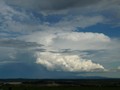
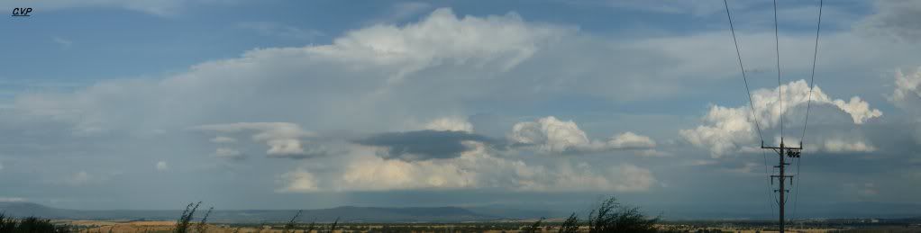
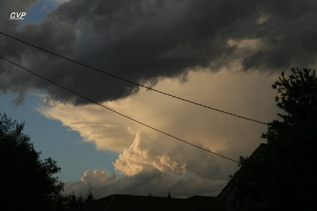
Below are some of the shots I took today. Most are taken from my house and the pano is taken from Mt. Ridley. I took these shots with the Canon Eos this time and am quite happy with the results. Hope you enjoy.
Here is a pano of the first cell which developed an anvil at around 7pm (I think). It grew to a large size before dissipating extremely quickly. I am really happy with this shot.
After we returned home, I noticed this cell directly above our heads! Was very small at the time and didn't show up on radar until about 10 minutes after this shot.
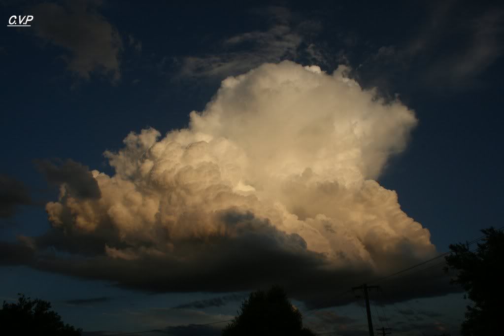
Here is another shot of it boiling up!
I then noticed a nice storm on the radar but couldn't find it outside? I had to wait for a couple of minutes for the clouds which were blocking my view to see it. It was a big anvil!
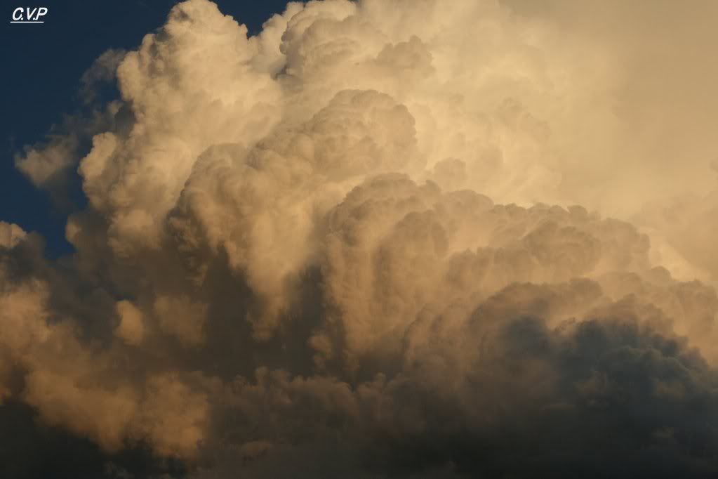
Another picture of it some time later.
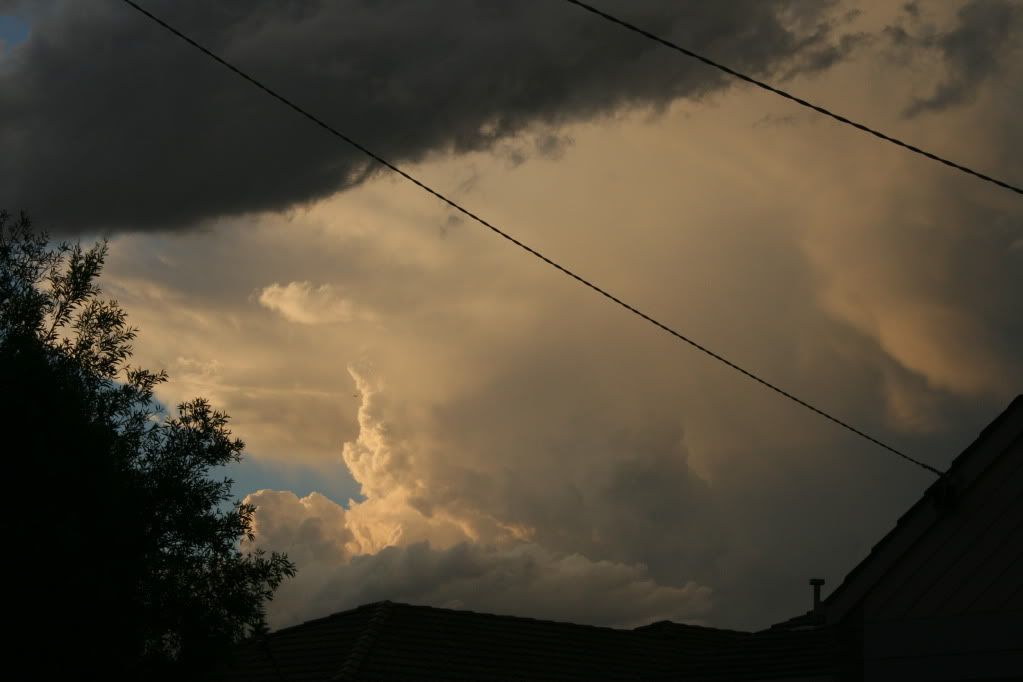
A little while later, I managed to get these shots of the same system.
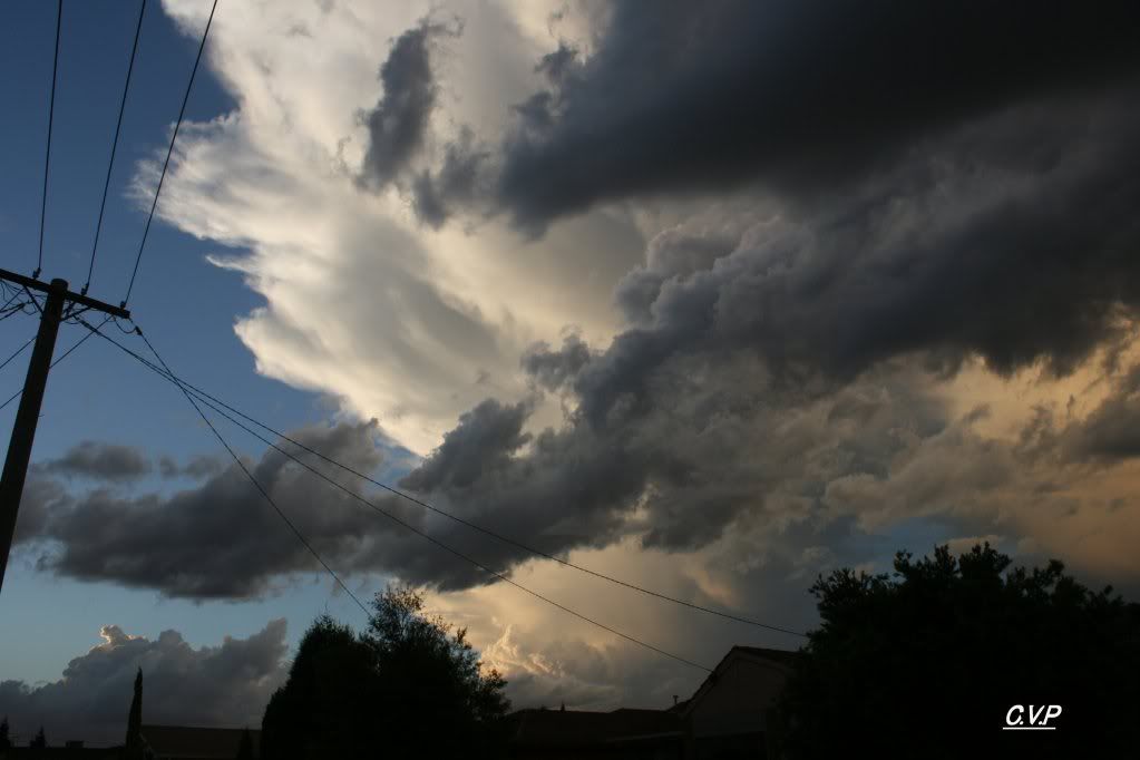
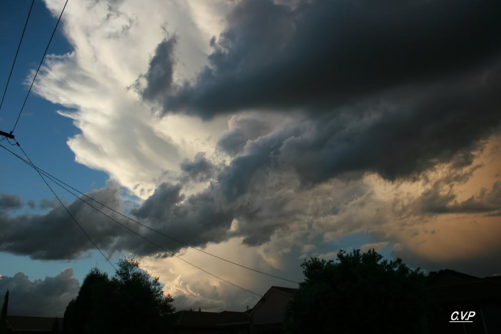
Hope you guys enjoyed the pics and hopefully the uploading went okay.
Cheers, Cam
Have decided to make an account with Photobucket. It should be easier to upload pics now!
Below are some of the shots I took today. Most are taken from my house and the pano is taken from Mt. Ridley. I took these shots with the Canon Eos this time and am quite happy with the results. Hope you enjoy.
Here is a pano of the first cell which developed an anvil at around 7pm (I think). It grew to a large size before dissipating extremely quickly. I am really happy with this shot.
After we returned home, I noticed this cell directly above our heads! Was very small at the time and didn't show up on radar until about 10 minutes after this shot.
Here is another shot of it boiling up!
I then noticed a nice storm on the radar but couldn't find it outside? I had to wait for a couple of minutes for the clouds which were blocking my view to see it. It was a big anvil!
Another picture of it some time later.
A little while later, I managed to get these shots of the same system.
Hope you guys enjoyed the pics and hopefully the uploading went okay.
Cheers, Cam
-
Karl Lijnders
- Tornadic Supercell
- Reactions:
- Posts: 5771
- Joined: Sun Nov 22, 2009 11:17 pm
- Location: Knoxfield, Victoria
Re: Victoria - Tropical rain event - February 2nd-8th 2010
They are wonderful pictures Cam!! Awesome stuff mate!! More more more!!! 
Interesting amount of Cu and Cj about the sky presently. All low based and moving ESE.
Could be a volitile day across the state.
Hard to focus on our weather with the violence up north
Interesting amount of Cu and Cj about the sky presently. All low based and moving ESE.
Could be a volitile day across the state.
Hard to focus on our weather with the violence up north
Former Owner - The Australian Weather Forum. Email me anytime - weatherman1000@hotmail.com
- CAPEcrusader
- Cumulus
- Reactions:
- Posts: 22
- Joined: Wed Jan 12, 2011 11:52 am
- Location: Geelong,sometimes Shepparton
Re: Victoria - Tropical rain event - February 2nd-8th 2010
With the High near New Zealand and what looks like a few cold fronts heading our way over the next few days would i be right in thinking that those mechanics combined will work to push rainfall fairly quickly to the south east. Is that why iam seeing more showers predicted than rain or even heavy rain , or aren't the models and forecasts on top of things ? Around the 7th airmasses from the north may be able to sit a bit more ?Maybe for another forum topic but iam wondering how much of this tropical airmass will end up in the southern jet , and if it does get there what impact this will have in the future. Would it be like putting a bucket load of tropical moisture in the freezer ?
anyway i'll be in Shepp on the weekend and that supercell forecast looks interesting
anyway i'll be in Shepp on the weekend and that supercell forecast looks interesting
"Understand, it's time to get ready for the storm"-SRV
-
daviescr

- Supercell
- Reactions:
- Posts: 1394
- Joined: Wed Dec 02, 2009 5:40 pm
- Location: Warranwood, Vic
Re: Victoria - Tropical rain event - February 2nd-8th 2010
Yes, EC has been pretty steady as she goes for the last 4 days on this, stabilising at about 60-90mm for here. GFS seems to be struggling for central, but very solid for the north of VIC. I'll go middle ground and pencil in 75mm for here by Sunday
Re: Victoria - Tropical rain event - February 2nd-8th 2010
24 mm overnight total so far 29 mm.
Re: Victoria - Tropical rain event - February 2nd-8th 2010
UKMET has around 100mm for Central including Melbourne and NE parts of Victoria
-
stratospear

- Supercell
- Reactions:
- Posts: 1261
- Joined: Sat Dec 19, 2009 9:38 am
- Location: Usually Bendigo
Re: Victoria - Tropical rain event - February 2nd-8th 2010
Still lots of divergence in the models. BOM downplaying it in their forecast, EC bullish, GFS now pushing much of Saturday's rain way north...
I think 25 - 50mm for here. Mostly Friday evening/Saturday morning.
I think 25 - 50mm for here. Mostly Friday evening/Saturday morning.
-
Karl Lijnders
- Tornadic Supercell
- Reactions:
- Posts: 5771
- Joined: Sun Nov 22, 2009 11:17 pm
- Location: Knoxfield, Victoria
Re: Victoria - Tropical rain event - February 2nd-8th 2010
GFS is the outlier. ACCESS, UK, EC, CMC and JMA all have substantial falls.
Widespread 50-100mm through C areas and 200mm in the NE.
Widespread 50-100mm through C areas and 200mm in the NE.
Former Owner - The Australian Weather Forum. Email me anytime - weatherman1000@hotmail.com
-
Anthony Violi

- Supercell
- Reactions:
- Posts: 2652
- Joined: Mon Nov 23, 2009 9:03 pm
- Location: Lilydale
- Contact:
Re: Victoria - Tropical rain event - February 2nd-8th 2010
It's is bizarre...GFS just doesn't see that we will cop a caning, all the other models give us 100mm plus increasing as it progresses Eastwards..maybe will come on next run.
Expecting a deluge next 72 hours with the atmosphere primed try again but this time cold air interaction.
Expecting a deluge next 72 hours with the atmosphere primed try again but this time cold air interaction.
http://www.therealworldweatherforum.com" onclick="window.open(this.href);return false;
avweatherforecasts.com
avweatherforecasts.com
- Harley34
- Cumulonumbus Calvas
- Reactions:
- Posts: 580
- Joined: Sat Mar 06, 2010 1:08 pm
- Location: Ringwood East, Melbourne
Re: Victoria - Tropical rain event - February 2nd-8th 2010
Wow ok, so i now have access to my old account again, which is good.
Pretty cool today, but i really do hope something happens tomorrow. I can see decent rainfall totals occurring on Saturday, but tomorrow has my interest, in terms of TS development.
Did see a decent cell with a whispy anvil shoot up in the evening yesterday to my NW, but it quickly dissipated, perhaps tomorrow we could see a outrageous line of storms head for Melbourne. What are the chances for today?, Wouldn't mind seeing that BOM storm chart, as soon as it's available.
-
stratospear
- Supercell
- Reactions:
- Posts: 1261
- Joined: Sat Dec 19, 2009 9:38 am
- Location: Usually Bendigo
Re: Victoria - Tropical rain event - February 2nd-8th 2010
Very sub-tropical outside. DP of 21. Fairly ordinary and flat stratocumulus cloud around. Am I in Brisbane or Bendigo atm?
- HarleyB
- Cumulonumbus Calvas
- Reactions:
- Posts: 839
- Joined: Sun Oct 10, 2010 9:39 pm
- Location: Wangaratta
Re: Victoria - Tropical rain event - February 2nd-8th 2010
We have a beautiful blue sky out here atm. Temp is 27.9 and rising! Dunno about the rain here... maybe 60mm as a start?
-
Karl Lijnders
- Tornadic Supercell
- Reactions:
- Posts: 5771
- Joined: Sun Nov 22, 2009 11:17 pm
- Location: Knoxfield, Victoria
Re: Victoria - Tropical rain event - February 2nd-8th 2010
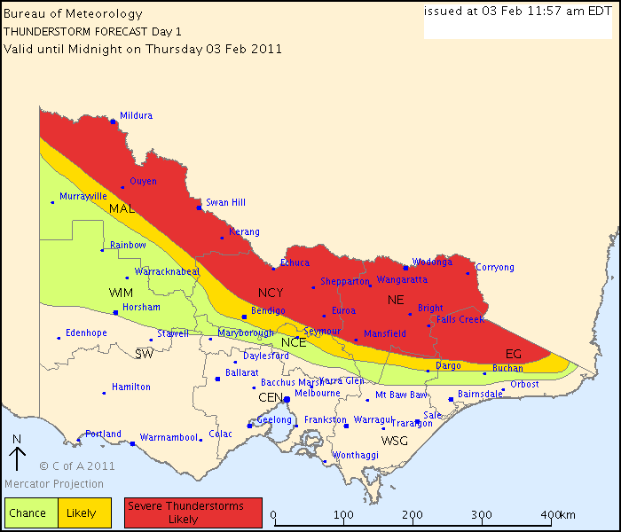
Australian Government Bureau of Meteorology
Victoria Regional Office
THUNDERSTORM FORECAST
Issued at 11:57 am Thursday, 3 February 2011,
Valid until midnight on Thursday, 3 February 2011.
A humid, warm and unstable airmass remains over northern and eastern Victoria while cooler and drier southerly winds have developed over most of southern Victoria. A low pressure trough is lingering over northern Victoria so thunderstorm activity is forecast in the marked areas. Extremely high levels of moisture are present so there is the significant chance of flash flooding. Large hail and damaging winds are less likely but are also possible.
Former Owner - The Australian Weather Forum. Email me anytime - weatherman1000@hotmail.com
- Jake Smethurst
- Supercell
- Reactions:
- Posts: 3583
- Joined: Mon Nov 23, 2009 8:49 pm
- Location: Cheltenham
Re: Victoria - Tropical rain event - February 2nd-8th 2010
I agree with that storm chart 100%. Any activity today is going to be restricted to along and north of the troughline. Watch for flash flooding today with any thunderstorms potentially bringing up to 40-50mm quick time. Otherwise southern areas will be mostly fine for the rest of today, just drizzle and cloud clearing from the central and Gippsland coasts. Less than 10% risk for showers/storms in the south. Its fine and sunny here, 22 degrees, DP of 15.
As for the upcoming event. Showers and thunderstorms on Friday are likely to tend to areas of rain from the west (excluding the southwest) later Friday and on Friday night. This will persist across most of the state on Saturday (except the southwest) before clearing to isolated showers from the west later Saturday. Totals generally between 50-100mm, locally higher in the northeast. The southwest is going to miss out on this rain event, which is unfortunate in some parts as things are now quite dry here. Grass is yellow on farms and there has been minimal regrowth recently. A little worrying actually with some curring visibly evident. We should see showers/storms Friday, but thats the best for here with just lighter patchy rainfall Saturday morning, maybe 5-10mm, unless Friday brings heavier falls from storms.
As for the upcoming event. Showers and thunderstorms on Friday are likely to tend to areas of rain from the west (excluding the southwest) later Friday and on Friday night. This will persist across most of the state on Saturday (except the southwest) before clearing to isolated showers from the west later Saturday. Totals generally between 50-100mm, locally higher in the northeast. The southwest is going to miss out on this rain event, which is unfortunate in some parts as things are now quite dry here. Grass is yellow on farms and there has been minimal regrowth recently. A little worrying actually with some curring visibly evident. We should see showers/storms Friday, but thats the best for here with just lighter patchy rainfall Saturday morning, maybe 5-10mm, unless Friday brings heavier falls from storms.
Jake - Senior AWF Forecaster
Feel free to send me a private message if you have any questions.
Feel free to send me a private message if you have any questions.