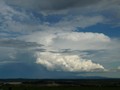
Some really nice cells developing to our North, North East and South East. The biggest one at the moment is probably the one to our SE. Probably going to see some anvils soon if they keep growing at this rate!
Cheers, Cam

Welcome New Members! We want to hear from you. Register, stop lurking and start posting!
Victoria - Tropical rain event - February 2nd-8th 2011
- Proteous
- Cumulonimbus
- Reactions:
- Posts: 200
- Joined: Fri Nov 27, 2009 4:57 pm
- Location: Paynesville Gippsland Lakes.
Re: Victoria - Tropical rain event - February 2nd-8th 2010
Don't give up on this one Petros I have a feeling in my water about this one. I believe it will start to rain later tonight and by Sunday have something in the order of 50 to 75mm.  Currently 28/19
-
Karl Lijnders

- Tornadic Supercell
- Reactions:
- Posts: 5771
- Joined: Sun Nov 22, 2009 11:17 pm
- Location: Knoxfield, Victoria
Re: Victoria - Tropical rain event - February 2nd-8th 2010
It was not just GFS that picked the trough placement. I love the model swinging on here sometimes rofl! ACCESS too has had it to the east, just. NOGAPS as well.
Saturday will hopefully fix the rainfall issues that some are inventing!
Saturday will hopefully fix the rainfall issues that some are inventing!
Former Owner - The Australian Weather Forum. Email me anytime - weatherman1000@hotmail.com
Re: Victoria - Tropical rain event - February 2nd-8th 2010
hillybilly wrote:Big cells going up in the Yarra Valley but all to the east of the Dandenongs. Shame as we could do with some rain
GFS seems to have picked the troughs position well with the action northeast of Melbourne today/tomorrow.
We shall see.. Latest EC has showers and isolated storms dev from Charlton to Melbourne Overnight even UK has instability so game not over yet
Re: Victoria - Tropical rain event - February 2nd-8th 2010
Proteous wrote:Don't give up on this one Petros I have a feeling in my water about this one. I believe it will start to rain later tonight and by Sunday have something in the order of 50 to 75mm.
I tend to agree Proteous
- Storm2
- Cumulus
- Reactions:
- Posts: 66
- Joined: Fri Sep 03, 2010 9:32 pm
- Location: Gippsland= Latrobe Valley - Newborough
Re: Victoria - Tropical rain event - February 2nd-8th 2010
Currently have a small cell rumbling away to my north east heading towards traralgon
- Twister
- Cumulonumbus Calvas
- Reactions:
- Posts: 914
- Joined: Sun Nov 29, 2009 10:47 pm
- Location: Brisbane Qld
Re: Victoria - Tropical rain event - February 2nd-8th 2010
Everyone swaps models in here
Impressive that Ex TC Antony still has some form and structure and moving to the SE into NE VIC and SE NSW.
Its looking very wet for N, NE Vic could see few 50-80mm falls and few 100mm falls around the place hopefully the NE get the big falls and the NW miss out but not looking likely atm.
Melb should see some solid rain to on Friday and Saturday
Showers starting to pop up to the NE N NW
The Dps are nuts though, across N Vic and NSW and Qld Dps are in the 20-24c range its unreal how moist this air is
Another warm day and nice convection to my E, NE
Should be a wet night in the NE
Last edited by Twister on Wed Feb 02, 2011 6:42 pm, edited 1 time in total.
Now Living in Wet QLD
- HarleyB
- Cumulonumbus Calvas
- Reactions:
- Posts: 839
- Joined: Sun Oct 10, 2010 9:39 pm
- Location: Wangaratta
Re: Victoria - Tropical rain event - February 2nd-8th 2010
Reckon cricket season is done here for me. Only got 2 weeks to go and only have a 1% chance of playing this week, and late next week looks wet again (sorry for off topic.)
Storms to the north look menacing, there are really good towers to the north. Was again quite hot today, up to 35.9 today
Storms to the north look menacing, there are really good towers to the north. Was again quite hot today, up to 35.9 today
-
Australis(Shell3155)

- Supercell
- Reactions:
- Posts: 3147
- Joined: Mon Nov 30, 2009 8:05 pm
- Location: FTG
- Contact:
Re: Victoria - Tropical rain event - February 2nd-8th 2010
34.5c. not nice pushing a mower around..
- AmaroK
- Cumulonimbus
- Reactions:
- Posts: 186
- Joined: Thu Nov 26, 2009 6:23 pm
- Location: Home Lysterfield....Work Bayswater.
Re: Victoria - Tropical rain event - February 2nd-8th 2010
can see some beautiful towers to my north but they are absolutely flying, pretty much moved out of my field of view (which is pretty wide) in about 10 minutes
Jason: The Token Weather Noob
-
Australis(Shell3155)
- Supercell
- Reactions:
- Posts: 3147
- Joined: Mon Nov 30, 2009 8:05 pm
- Location: FTG
- Contact:
Re: Victoria - Tropical rain event - February 2nd-8th 2010
Today is the first that I have had any dust (slight)while mowing lawns, and we have lawns now browning off,
gone from mowing a few notches down from the top to fully raised on most parts.
Defiantly need some rain parts are really drying out here. Tanks are getting low.
gone from mowing a few notches down from the top to fully raised on most parts.
Defiantly need some rain parts are really drying out here. Tanks are getting low.
-
flatcam
- Cumulonimbus
- Reactions:
- Posts: 182
- Joined: Wed Jan 05, 2011 8:16 pm
- Location: Craigieburn, Victoria
Re: Victoria - Tropical rain event - February 2nd-8th 2010
Quite a large anvil heading our way now!  Just went outside for a look at it appears to be larger than the one which formed just before. Did anyone else see that one?
I managed to get a pano of it and will try to upload soon.
The line of developing storms seems to have moved further West and it looks as if we are pretty much in the firing line here.
Going to be some lovely action soon.
Cheers, Cam
I managed to get a pano of it and will try to upload soon.
The line of developing storms seems to have moved further West and it looks as if we are pretty much in the firing line here.
Going to be some lovely action soon.
Cheers, Cam
Last edited by flatcam on Wed Feb 02, 2011 7:47 pm, edited 1 time in total.
- droughtbreaker
- Supercell
- Reactions:
- Posts: 2844
- Joined: Wed Nov 25, 2009 7:50 pm
- Location: Mount Macedon, VIC, 520m asl
Re: Victoria - Tropical rain event - February 2nd-8th 2010
Just had a 'sunstorm'. A few rumbles of thunder and then a brief very heavy shower whilst the sun stayed out the whole time. It was very photogenic.
BTW, some very nice Cb structure out there. They are tiny cells but are showing some decent vertical development and quite rapid development as well.
BTW, some very nice Cb structure out there. They are tiny cells but are showing some decent vertical development and quite rapid development as well.
Re: Victoria - Tropical rain event - February 2nd-8th 2010
What a beauty to my NW!
- droughtbreaker
- Supercell
- Reactions:
- Posts: 2844
- Joined: Wed Nov 25, 2009 7:50 pm
- Location: Mount Macedon, VIC, 520m asl
Re: Victoria - Tropical rain event - February 2nd-8th 2010
Heavy rainfall again with another cell. Looks like sea breeze convergence is helping us out with storms here.
-
dagget

- Cumulonimbus
- Reactions:
- Posts: 480
- Joined: Sun Nov 29, 2009 10:35 pm
- Location: Trentham (705m ASL)
Re: Victoria - Tropical rain event - February 2nd-8th 2010
Good show from the last couple of cells here, nice rumbles and even brief hail...dont like the humidity increase though
Re: Victoria - Tropical rain event - February 2nd-8th 2010
hillybilly wrote:EC has plenty of rain for us from Friday/Saturday so it may come good, but GFS completely disagrees. I'd usually back EC in over GFS, but such a split is odd, and for today EC has fallen into line with GFS.
The 4000+ hectare fire in Gippsland and the fires around Inverloch yesterday show the reality. People outside of the bush don't realise that areas from the Dandenongs through to Gabo Island have not done that great in the last year - this goes from Decile 6 to around Decile 3. When you have had 14 year of below average rainfall, average or 100mm above doesn't remove the dryness. If you look at Melbourne's catchments the inflow this last year have been well below the long-term average again. We need another rain event to close out the fire season.Saturday will hopefully fix the rainfall issues that some are inventing!
Um decile 6 in the Dandenongs the past Year?????? Says decile 8-9 here! Your own BOM Map! So not sure where your pulling that from.
http://www.bom.gov.au/jsp/awap/rain/ind ... th&area=vc" onclick="window.open(this.href);return false;
And Gippsland hasn't been in Decile 3, it falls inbetween the Decile 4 to 7 category so at worse its been a decile 4 or 5 there, not sure when it comes to rainfall David how you always underestimate to make a point
- droughtbreaker
- Supercell
- Reactions:
- Posts: 2844
- Joined: Wed Nov 25, 2009 7:50 pm
- Location: Mount Macedon, VIC, 520m asl
Re: Victoria - Tropical rain event - February 2nd-8th 2010
Well, a really nice, classic summer storm there. A few rumbles here and there, some modest gusts and heavy rain that lasted about 15 minutes. Humidity is locked into insane mode.
-
Anthony Violi

- Supercell
- Reactions:
- Posts: 2652
- Joined: Mon Nov 23, 2009 9:03 pm
- Location: Lilydale
- Contact:
Re: Victoria - Tropical rain event - February 2nd-8th 2010
Its starting to break now, i think it will be a noisy night out here, and then the next few days i expect easily 100mm here, maybe more.
GFS is off its guts with this one, most models have us borderline 100mm, Ec and CMC have us comfortably 100mm..
GFS starts the 50mm 200 kms to far NE, not sure how because the cold air interaction is going to cause an enormous thundery rain band with flash flooding on Saturday. In fact it has no rain for the NW where there is a rain band with a black cored storm right now moving into Renmark.
http://www.therealworldweatherforum.com" onclick="window.open(this.href);return false;
avweatherforecasts.com
avweatherforecasts.com
Re: Victoria - Tropical rain event - February 2nd-8th 2010
Massive Cu here, had to take some photos !
http://www.flickr.com/photos/58174898@N05/" onclick="window.open(this.href);return false;
Hope it works, just tell me if it doesn't and i'll work on it!
http://www.flickr.com/photos/58174898@N05/" onclick="window.open(this.href);return false;
Hope it works, just tell me if it doesn't and i'll work on it!
Go the bombersss!