Got gusty cooler southeasterly winds here which I suspect is outflow from the storms that were to our east. These easterlies are then converging with the weak sw'ly change which is feeding the storms to the southwest. The convergence is really firing up... Interesting to watch how far east the SWly change makes it before it slips away.
Had two showers this arvo but nothing recordable.

Welcome New Members! We want to hear from you. Register, stop lurking and start posting!
Warm to hot and unstable: Feb 6 onwards
-
hillybilly

- Site Admin/Moderator
- Reactions:
- Posts: 5048
- Joined: Thu Nov 26, 2009 7:26 am
- Location: Howden Tasmania, 25m above sea level
- Contact:
-
typhoon29

- Cumulonumbus Calvas
- Reactions:
- Posts: 510
- Joined: Fri Jan 01, 2010 11:05 pm
- Location: Ballarat (Mitchell Park)
- Contact:
Re: Warm to hot and unstable: Feb 6 onwards
nothing here today everything seems to far south, just dry and hot
Ballarat, Home of the Anti-Thunderstorm Shield!
-
hillybilly
- Site Admin/Moderator
- Reactions:
- Posts: 5048
- Joined: Thu Nov 26, 2009 7:26 am
- Location: Howden Tasmania, 25m above sea level
- Contact:
Re: Warm to hot and unstable: Feb 6 onwards
Uncomfortable night up here... 23C for a minimum. Now waiting on the front.... Had enough of summer now.
Couple of showery bands... First dropping a couple of mm's in spots. Interesting storms already firing out west with a big cell to the west of the Otways.
Not sure what to expect here... Could be anywhere between 0.2 and 20mm depending on the timing on the front and the track of the showers. Better the further east tou get.
- Wilko
- Supercell
- Reactions:
- Posts: 1492
- Joined: Wed Aug 11, 2010 12:08 pm
- Location: Moorabbin & Highett, Vic
Re: Warm to hot and unstable: Feb 6 onwards
Line of thunderstorms following the change
Bureau Will most likely issue a severe thunderstorm warning
Bring it on
Bureau Will most likely issue a severe thunderstorm warning
Bring it on
Re: Warm to hot and unstable: Feb 6 onwards
Just tried calling a customer in Lismore VIC. All his computers are off and not answering the phone! Then I looked at Radar and can see why!
- I_Love_Storms
- Supercell
- Reactions:
- Posts: 2812
- Joined: Wed Dec 02, 2009 2:01 pm
- Location: Hawthorn
Re: Warm to hot and unstable: Feb 6 onwards
Max 29 Possible shower. Cool change.
Rainfall amount: 0 to 0.4 mm
STW for wide parts of the state including Melbourne...we will see how that 0 to 0.4mm goes
Rainfall amount: 0 to 0.4 mm
STW for wide parts of the state including Melbourne...we will see how that 0 to 0.4mm goes
- Skywalker
- Supercell
- Reactions:
- Posts: 1875
- Joined: Sun Nov 29, 2009 10:03 am
- Location: Burnside Heights/Cowes (Home) & Sunshine West (Work)
Re: Warm to hot and unstable: Feb 6 onwards
Will be luck of the draw here again. Not holding my breath.
Caroline Springs, Melbourne's meteorological boredom zone.
-
Rivergirl

- Memorial
- Reactions:
- Posts: 3674
- Joined: Sun Nov 22, 2009 6:04 pm
- Location: Ferny Creek VIC
- Contact:
Re: Warm to hot and unstable: Feb 6 onwards
SEVERE THUNDERSTORM WARNING
for DAMAGING WIND, HEAVY RAINFALL and LARGE HAILSTONES
For people in the Central, Mallee, South West, Northern Country, North Central, West and South Gippsland and Wimmera Forecast Districts.
Issued at 9:50 am Monday, 23 February 2015.
Severe thunderstorms are likely to produce damaging winds, heavy rainfall that may lead to flash flooding and large hailstones in the warning area over the next several hours. Locations which may be affected include Mildura, Horsham, Ballarat, Bendigo, Shepparton, Seymour, Maryborough, Geelong, Melbourne and Traralgon.
The State Emergency Service advises that people should:
* Keep clear of fallen power lines.
* secure any loose objects in the vicinity of your home.
* keep away from creeks and drains.
* do not drive vehicles through flooded areas.
* stay indoors if possible.
* Avoid using the phone during the storm.
* if you are outside, avoid sheltering under trees
* listen to the radio for storm updates
* switch off your computer and electrical appliances
The next warning is due to be issued by 12:50 pm.
If severe thunderstorms develop in the Melbourne Area, a more detailed Severe Thunderstorm Warning will be issued to people in this area.
http://www.bom.gov.au
- Jake Smethurst
- Supercell
- Reactions:
- Posts: 3583
- Joined: Mon Nov 23, 2009 8:49 pm
- Location: Cheltenham
Re: Warm to hot and unstable: Feb 6 onwards
My parents text me this morning saying they had another pretty nasty storm, mostly the lightning they said was intense. That's their third storm in three days .. jealous!
It will be quite hit and miss still, as with the nature of the storm, some will get lucky and others will miss out completely. Managed to see a small cell go up over the bay a short time ago, though has now dissipated mostly. It will certainly be interesting to see what happens when this line gets here.
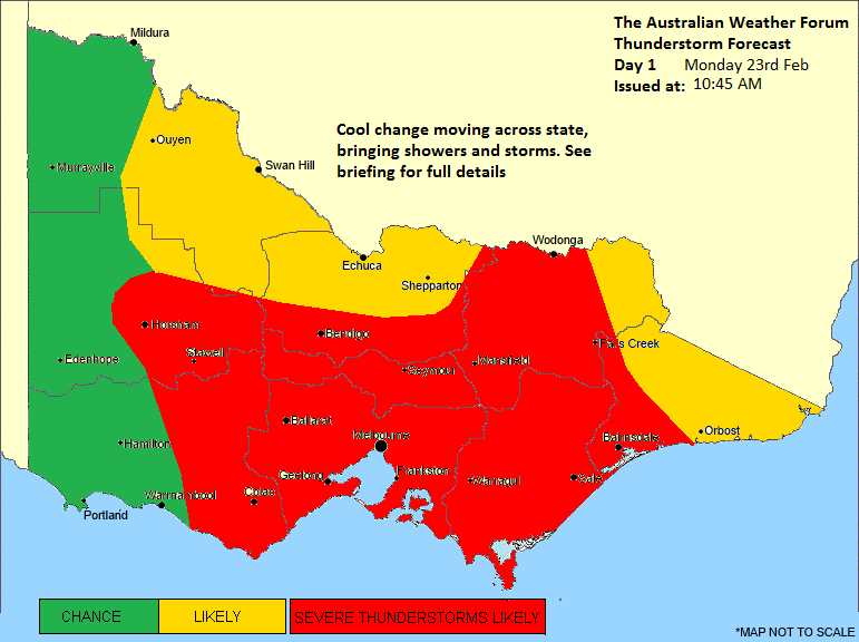
Here's our storm chart for today, not that we really need it given the radar at the moment
Thunderstorm Forecast - Day 1
Issued at 10:45am Monday 23rd February 2015
Discussion for Monday
A cooler change is progressing across Victoria this morning, and will reach central parts by midday before entering eastern districts this afternoon. Thunderstorm activity is already occurring near this cool change over southwest Victoria. For the rest of today, thunderstorms will be likely near and ahead of this change as it progresses eastwards. Further development is most likely over central and eastern districts thanks to warm surface temperatures, a very saturated atmospheric environment, and unstable conditions. Severe thunderstorms are very likely today, particularly in the area we have marked, and near the cool change. All severe phenomena (damaging winds, large hailstones, flash flooding) are possible from thunderstorms today, and the Bureau of Meteorology already have a warning current for these variables. Following the cool change, the risk of thunderstorm activity diminishes, however mid-level non-severe thundery showers will remain possible for a number of hours.
It will be quite hit and miss still, as with the nature of the storm, some will get lucky and others will miss out completely. Managed to see a small cell go up over the bay a short time ago, though has now dissipated mostly. It will certainly be interesting to see what happens when this line gets here.
Here's our storm chart for today, not that we really need it given the radar at the moment
Thunderstorm Forecast - Day 1
Issued at 10:45am Monday 23rd February 2015
Discussion for Monday
A cooler change is progressing across Victoria this morning, and will reach central parts by midday before entering eastern districts this afternoon. Thunderstorm activity is already occurring near this cool change over southwest Victoria. For the rest of today, thunderstorms will be likely near and ahead of this change as it progresses eastwards. Further development is most likely over central and eastern districts thanks to warm surface temperatures, a very saturated atmospheric environment, and unstable conditions. Severe thunderstorms are very likely today, particularly in the area we have marked, and near the cool change. All severe phenomena (damaging winds, large hailstones, flash flooding) are possible from thunderstorms today, and the Bureau of Meteorology already have a warning current for these variables. Following the cool change, the risk of thunderstorm activity diminishes, however mid-level non-severe thundery showers will remain possible for a number of hours.
Jake - Senior AWF Forecaster
Feel free to send me a private message if you have any questions.
Feel free to send me a private message if you have any questions.
- stevco123
- Supercell
- Reactions:
- Posts: 2944
- Joined: Sat Aug 07, 2010 7:42 pm
- Location: Cranbourne 78m asl
Re: Warm to hot and unstable: Feb 6 onwards
I_Love_Storms » Mon Feb 23, 2015 9:01 am wrote:I_Love_Storms wrote:Max 29 Possible shower. Cool change.
Rainfall amount: 0 to 0.4 mm
STW for wide parts of the state including Melbourne...we will see how that 0 to 0.4mm goes
Let's not get ahead of ourselves.
Too many times weather dies out to the west before it hits us in Melbourne.
Ofcourse, I want to be wrong this time
https://www.weatherlink.com/bulletin/53 ... 76dd68e8bc: for current weather updated every 2 minutes
- Skywalker
- Supercell
- Reactions:
- Posts: 1875
- Joined: Sun Nov 29, 2009 10:03 am
- Location: Burnside Heights/Cowes (Home) & Sunshine West (Work)
Re: Warm to hot and unstable: Feb 6 onwards
IDV65752
Australian Government Bureau of Meteorology
Victoria Regional Office
TOP PRIORITY FOR IMMEDIATE BROADCAST
SEVERE THUNDERSTORM WARNING - MELBOURNE AREA
for DAMAGING WIND, HEAVY RAINFALL and LARGE HAILSTONES
For people in the
Geelong and Bellarine Peninsula and parts of the
Port Phillip and
Western Local Warning Areas.
Issued at 10:56 am Monday, 23 February 2015.
The Bureau of Meteorology warns that, at 10:50 am, severe thunderstorms were detected on weather radar near Rokewood, Winchelsea, the area northwest of Ballan, the area east of Linton, Aireys Inlet and Bass Strait. These thunderstorms are moving towards the east to southeast. They are forecast to affect Geelong City, Torquay and the area west of Geelong City by 11:20 am and Lara, Queenscliff and Sorrento by 11:50 am.
Damaging winds, heavy rainfall that may lead to flash flooding and large hailstones are likely.
The State Emergency Service advises that people should:
* Keep clear of fallen power lines.
* secure any loose objects in the vicinity of your home.
* keep away from creeks and drains.
* do not drive vehicles through flooded areas.
* stay indoors if possible.
* Avoid using the phone during the storm.
* if you are outside, avoid sheltering under trees
* listen to the radio for storm updates
* switch off your computer and electrical appliances
The next warning is due to be issued by 11:55 am.
A more general severe thunderstorm warning is also current for the Central, Mallee, South West, Northern Country, North Central, West and South Gippsland and Wimmera districts.
Warnings are also available through TV and Radio broadcasts, the Bureau's website at http://www.bom.gov.au" onclick="window.open(this.href);return false; or call 1300 659 217. The Bureau and State Emergency Service would appreciate warnings being broadcast regularly.
Caroline Springs, Melbourne's meteorological boredom zone.
-
Australis(Shell3155)

- Supercell
- Reactions:
- Posts: 3148
- Joined: Mon Nov 30, 2009 8:05 pm
- Location: FTG
- Contact:
- stevco123
- Supercell
- Reactions:
- Posts: 2944
- Joined: Sat Aug 07, 2010 7:42 pm
- Location: Cranbourne 78m asl
Re: Warm to hot and unstable: Feb 6 onwards
Reports of large hail and some broken windscreens and car damage near Cressy / Colac
https://www.weatherlink.com/bulletin/53 ... 76dd68e8bc: for current weather updated every 2 minutes
-
Australis(Shell3155)
- Supercell
- Reactions:
- Posts: 3148
- Joined: Mon Nov 30, 2009 8:05 pm
- Location: FTG
- Contact:
Re: Warm to hot and unstable: Feb 6 onwards
hold on.. this could get very interesting.. that radar is BLACK..
- Skywalker
- Supercell
- Reactions:
- Posts: 1875
- Joined: Sun Nov 29, 2009 10:03 am
- Location: Burnside Heights/Cowes (Home) & Sunshine West (Work)
Re: Warm to hot and unstable: Feb 6 onwards
Just sent a warning to my wife. She is at work down the road in St Albans.
If that line holds it's intensity we are in trouble. Going to get SMASHED!
We have moved our cars inside the warehouse here as a precaution.
If that line holds it's intensity we are in trouble. Going to get SMASHED!
We have moved our cars inside the warehouse here as a precaution.
Last edited by Skywalker on Mon Feb 23, 2015 11:56 am, edited 1 time in total.
Caroline Springs, Melbourne's meteorological boredom zone.
- StratoBendigo
- Supercell
- Reactions:
- Posts: 2844
- Joined: Fri Jan 02, 2015 2:18 pm
- Location: Kangaroo Flat
Re: Warm to hot and unstable: Feb 6 onwards
Some thunder in Bendigo with high-based storm clouds rapidly developing. And this is just the entree.
-
occluded

- Cumulonumbus Calvas
- Reactions:
- Posts: 611
- Joined: Tue May 04, 2010 3:26 pm
- Location: Mooroolbark 130m asl
Re: Warm to hot and unstable: Feb 6 onwards
Just started pouring at work in Box Hill South. Wow at the latest STW from the BOM. 
- I_Love_Storms
- Supercell
- Reactions:
- Posts: 2812
- Joined: Wed Dec 02, 2009 2:01 pm
- Location: Hawthorn
Re: Warm to hot and unstable: Feb 6 onwards
Hmm very nice climax to a few days of isolated big cells...looks like this one should get a few places, but quite short and sharp in nature. I'd be putting my car under cover
-
Rivergirl
- Memorial
- Reactions:
- Posts: 3674
- Joined: Sun Nov 22, 2009 6:04 pm
- Location: Ferny Creek VIC
- Contact:
Re: Warm to hot and unstable: Feb 6 onwards
SEVERE THUNDERSTORM WARNING - MELBOURNE AREA
for DAMAGING WIND, HEAVY RAINFALL and LARGE HAILSTONES
For people in the Port Phillip, Western Port, Inner East, Mornington Peninsula, Inner, South East, Northern, Western, Geelong and Bellarine Peninsula and parts of the Outer East Local Warning Areas.
Issued at 11:55 am Monday, 23 February 2015.
The Bureau of Meteorology warns that, at 11:50 am, severe thunderstorms were detected on weather radar near Geelong City, Queenscliff, Gisborne, the area east of Healesville, Broadmeadows, Little River, Bass Strait and the area south of Kilmore. These thunderstorms are moving towards the east to southeast. They are forecast to affect Craigieburn, Footscray, Melton, Preston, Ringwood, Rosebud, St Albans, Sunbury and Werribee by 12:20 pm and Caulfield, Frankston, Glen Waverley, Greensborough and Melbourne City by 12:50 pm.
Damaging winds, heavy rainfall that may lead to flash flooding and large hailstones are likely.
There has been reports of hail damage to cars with thunderstorms in the Colac/Cressy area.
The State Emergency Service advises that people should:
* Keep clear of fallen power lines.
* secure any loose objects in the vicinity of your home.
* keep away from creeks and drains.
* do not drive vehicles through flooded areas.
* stay indoors if possible.
* Avoid using the phone during the storm.
* if you are outside, avoid sheltering under trees
* listen to the radio for storm updates
* switch off your computer and electrical appliances
The next warning is due to be issued by 12:55 pm.
A more general severe thunderstorm warning is also current for the Central, Mallee, South West, Northern Country, North Central, West and South Gippsland and Wimmera districts.
Warnings are also available through TV and Radio broadcasts, the Bureau's website at http://www.bom.gov.au" onclick="window.open(this.href);return false; or call 1300 659 217. The Bureau and State Emergency Service would appreciate warnings being broadcast regularly.