
Welcome New Members! We want to hear from you. Register, stop lurking and start posting!
VIC: Warmth, Showers & Thunderstorms - Aug 24 to Sept 1 2013
-
Australis(Shell3155)

- Supercell
- Reactions:
- Posts: 3148
- Joined: Mon Nov 30, 2009 8:05 pm
- Location: FTG
- Contact:
-
Didjman

- Supercell
- Reactions:
- Posts: 2100
- Joined: Fri Sep 03, 2010 2:52 pm
- Location: Wallan, Vic 328m ASL
- Contact:
Re: VIC: Warmth, Showers & Thunderstorms - Aug 24 to Sept 1
Our minimum was 13c at midnight! 15c now.
Peter
Peter
- sparra
- Cumulonimbus
- Reactions:
- Posts: 103
- Joined: Mon Aug 08, 2011 11:11 am
- Location: Netherby, via Nhill
Re: VIC: Warmth, Showers & Thunderstorms - Aug 24 to Sept 1
Yes same here. Our lawn usually goes brown/dormant in the winter....don't mow it at all.....this year it is still as green as it always is during the warmer months and I have been mowing all winter!!hillybilly wrote: Certainly, locally seeing the effects of the lack of real cold withthe lawn which will need a cut this weekend. Usually get away without cutting lawns to September or even October up here
Not liking this unseasonal warmth as far as our crops go. They are all booming along but will use huge amounts of moisture during these warm days.
Our weather man is saying Sep/Oct will be dryer than normal (although for the last few years "dry" is normal) so hoping he is wrong cause after this week of warm weather we are going to need some rain.
- Jake Smethurst
- Supercell
- Reactions:
- Posts: 3583
- Joined: Mon Nov 23, 2009 8:49 pm
- Location: Cheltenham
Re: VIC: Warmth, Showers & Thunderstorms - Aug 24 to Sept 1
So just about to have a look at the latest guidance and update the thunderstorm chart. Will upload once completed. Very windy here at Monash, but nice and warm too!  Generally clearer air would be preferential for thunderstorm development this afternoon, however there does appear to be cell formation in SE South Australia currently and that's associated with the trough itself, so there is no doubt in my mind thunderstorms will develop this afternoon, initially in the west.
Jake - Senior AWF Forecaster
Feel free to send me a private message if you have any questions.
Feel free to send me a private message if you have any questions.
- Sugarlata
- Stratus
- Reactions:
- Posts: 11
- Joined: Wed Aug 28, 2013 10:33 am
- Location: H: Dandenong North | W: Mulgrave
Re: VIC: Warmth, Showers & Thunderstorms - Aug 24 to Sept 1
Interesting post by the Bureau of Meteorology on Facebook earlier on:
"SCENARIO: A strong cold front is expected to hit the coast, with severe wind gusts over a large area and the possibility of tornadoes. Tornadoes produce much stronger winds, over smaller areas.
QUESTION: If we were issuing a warning for this scenario, which of these wind descriptions do you think we should use?
a) Locally destructive winds
b) Damaging winds
c) Damaging and locally destructive winds"
Would highly recommend for people to get on Facebook and share their thoughts!
Link:https://www.facebook.com/bureauofmeteor ... ion=stream
Passionate (perhaps obsessive) weather observer
- Jake Smethurst
- Supercell
- Reactions:
- Posts: 3583
- Joined: Mon Nov 23, 2009 8:49 pm
- Location: Cheltenham
Re: VIC: Warmth, Showers & Thunderstorms - Aug 24 to Sept 1
Welcome to the forum Sugarlata! And yes I did see that post! Interesting 
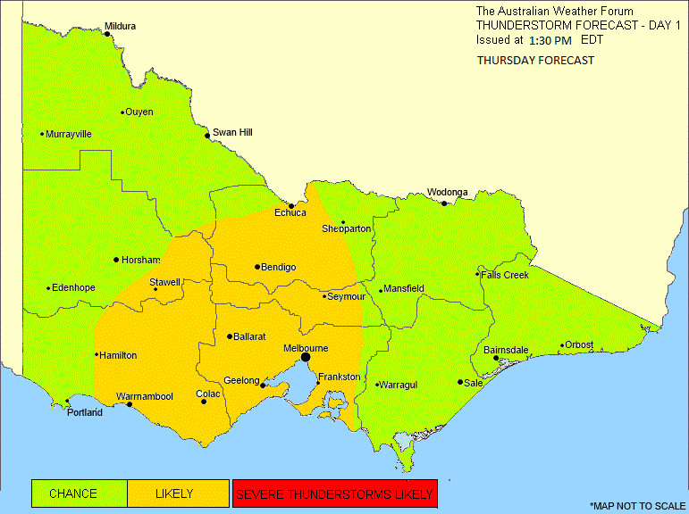
And I've just updated the charts. Day 2 can also be found at our website: http://www.theaustralianweatherforum.co ... ecast.html.
THUNDERSTORM FORECAST - DAY 1
Issued at: 1:40 PM Thursday 29th August 2013.
Discussion for Thursday:
An upper trough is expected to move into the west of the state during this afternoon and then approach central districts late this afternoon and evening. Generally, the environment is fertile for thunderstorm development, however there may be limitations on convection due to cloud cover and not warm enough surface temperatures. Nevertheless, other aspects of the atmospheric environment as mentioned are good, such as moisture levels, upper temperatures, as well as the trigger being the trough. It is expected that isolated thunderstorms are possible across any part of the state this afternoon, mainly near the trough, where extra forcing is available for initiation. The more likely region for thunderstorm development will be over parts of western and central Victoria (as indicated on the chart), where conditions such as shear are better. There is a possibility of severe thunderstorms today with the current shear environment - data shows that there is ample shear available at all levels for excellent outflow and inflow of cellular activity. This means the most likely severe phenomena will be damaging to even destructive winds. Large hailstones and flash flooding are less likely, but cannot be ruled out.
Jake - Senior AWF Forecaster
Feel free to send me a private message if you have any questions.
Feel free to send me a private message if you have any questions.
- Skywalker
- Supercell
- Reactions:
- Posts: 1876
- Joined: Sun Nov 29, 2009 10:03 am
- Location: Burnside Heights/Cowes (Home) & Sunshine West (Work)
Re: VIC: Warmth, Showers & Thunderstorms - Aug 24 to Sept 1
Welcome Sugarlata. Don't forget to include the location in your profile.
Thanks for the update Jake.
Very windy here at work, not sure if we will see much activity out this way. Would be nice if this cloud cover would disappear.
Thanks for the update Jake.
Very windy here at work, not sure if we will see much activity out this way. Would be nice if this cloud cover would disappear.
Caroline Springs, Melbourne's meteorological boredom zone.
- Wilko
- Supercell
- Reactions:
- Posts: 1492
- Joined: Wed Aug 11, 2010 12:08 pm
- Location: Moorabbin & Highett, Vic
Re: VIC: Warmth, Showers & Thunderstorms - Aug 24 to Sept 1
Cells are firing up on the SA border in a big way
Could become quite severe looking closely at the Radar
My prediction is for some big action later this arvo..may get the camera ready
Could become quite severe looking closely at the Radar
My prediction is for some big action later this arvo..may get the camera ready
- Jake Smethurst
- Supercell
- Reactions:
- Posts: 3583
- Joined: Mon Nov 23, 2009 8:49 pm
- Location: Cheltenham
Re: VIC: Warmth, Showers & Thunderstorms - Aug 24 to Sept 1
And here we go! I knew I should have included likely for the Mallee!! Grrr. 
Australian Government Bureau of Meteorology
Victoria Regional Office
TOP PRIORITY FOR IMMEDIATE BROADCAST
SEVERE THUNDERSTORM WARNING
for DAMAGING WIND
For people in the
Wimmera and parts of the
Mallee and
South West Forecast Districts.
Issued at 2:02 pm Thursday, 29 August 2013.
Severe thunderstorms are likely to produce damaging winds in the warning area over the next several hours. Locations which may be affected include Mildura, Ouyen, Walpeup, Horsham, Warracknabeal and Portland.
Jake - Senior AWF Forecaster
Feel free to send me a private message if you have any questions.
Feel free to send me a private message if you have any questions.
- Sugarlata
- Stratus
- Reactions:
- Posts: 11
- Joined: Wed Aug 28, 2013 10:33 am
- Location: H: Dandenong North | W: Mulgrave
Re: VIC: Warmth, Showers & Thunderstorms - Aug 24 to Sept 1
Haha, thanks for the welcome everyone, but I've actually been around here for a while! Used to be known as greensyboy, but since moving away from Greensborough I thought that I should probably have a profile that is a little more accurate and won't change over time (Sugarlata being my nickname).
Passionate (perhaps obsessive) weather observer
- sparra
- Cumulonimbus
- Reactions:
- Posts: 103
- Joined: Mon Aug 08, 2011 11:11 am
- Location: Netherby, via Nhill
Re: VIC: Warmth, Showers & Thunderstorms - Aug 24 to Sept 1
Can hear some rumbles outside and sky looks stormy....looking at the radar it looks like a storm on it's way......shearing today.....good thing we shedded all we need for tomorrow.....wait and see....
- Jake Smethurst
- Supercell
- Reactions:
- Posts: 3583
- Joined: Mon Nov 23, 2009 8:49 pm
- Location: Cheltenham
Re: VIC: Warmth, Showers & Thunderstorms - Aug 24 to Sept 1
Good luck Sparra! Only a few mm's!
AWF SEVERE THUNDERSTORM ADVICE
Please use official warnings from the Bureau of Meteorology for professional services.
A line of thunderstorms has developed from roughly KINGSTON in South Australia to roughly WALPEUP in Victoria. The line of thunderstorms is moving southeast and will affect much of the Mallee, Wimmera and Southwest forecast districts during the next few hours. Please note that there is the potential for damaging winds between 90-100 km/h with thunderstorms.
Jake - Senior AWF Forecaster
Feel free to send me a private message if you have any questions.
Feel free to send me a private message if you have any questions.
- Jake Smethurst
- Supercell
- Reactions:
- Posts: 3583
- Joined: Mon Nov 23, 2009 8:49 pm
- Location: Cheltenham
Re: VIC: Warmth, Showers & Thunderstorms - Aug 24 to Sept 1
Bit of a band of rain heading over central regions at the moment! A few mm's in that! Potential for the band of rain to moisten things up and cause a few thunderstorms for central areas later.
AWF SEVERE THUNDERSTORM ADVICE
Please use official warnings from the Bureau of Meteorology for professional services.
The line of thunderstorms that was affecting the western districts has weakened. Currently there is minimal thunderstorm activity. The advice is therefore cancelled. Please note that thunderstorms remain possible this evening and will be monitored closely by the Australian Weather Forum team.
Jake - Senior AWF Forecaster
Feel free to send me a private message if you have any questions.
Feel free to send me a private message if you have any questions.
- Macedonian
- Supercell
- Reactions:
- Posts: 2342
- Joined: Mon Dec 21, 2009 10:44 pm
- Location: Mount Macedon Vic at 870m above sea level
Re: VIC: Warmth, Showers & Thunderstorms - Aug 24 to Sept 1
its hammering down here now, very heavy rain
Home- "Shepherd's Bush" at Mt Macedon. 870m
Work- "Bolobek" at Macedon. 430m
Work- "Bolobek" at Macedon. 430m
- SC.
- Cumulonimbus
- Reactions:
- Posts: 346
- Joined: Wed Nov 25, 2009 5:57 pm
- Location: Wheelers Hill
- Contact:
Re: VIC: Warmth, Showers & Thunderstorms - Aug 24 to Sept 1
Starting to rain here but went outside to look at the incoming rainband and the clouds look too high and non threatening atm. If this was summer with more heat...it would be a different story. Still, a few mm would be good.
- Skywalker
- Supercell
- Reactions:
- Posts: 1876
- Joined: Sun Nov 29, 2009 10:03 am
- Location: Burnside Heights/Cowes (Home) & Sunshine West (Work)
Re: VIC: Warmth, Showers & Thunderstorms - Aug 24 to Sept 1
WOW! Where has this come from! 
One minute weeding, next minute bang, washed out!
One minute weeding, next minute bang, washed out!
Caroline Springs, Melbourne's meteorological boredom zone.
- Jake Smethurst
- Supercell
- Reactions:
- Posts: 3583
- Joined: Mon Nov 23, 2009 8:49 pm
- Location: Cheltenham
Re: VIC: Warmth, Showers & Thunderstorms - Aug 24 to Sept 1
AWF ROAD WEATHER ADVICE
Please use official warnings from the Bureau of Meteorology for professional services.
A band of rain is currently encroaching on the MELBOURNE area with moderate to heavy rain rates. This may lead to some hazardous driving conditions for a few hours this evening. Reports of hazardous driving have already been received for northern and western suburbs.
Jake - Senior AWF Forecaster
Feel free to send me a private message if you have any questions.
Feel free to send me a private message if you have any questions.
- Geoff
- Supercell
- Reactions:
- Posts: 2538
- Joined: Tue Jul 05, 2011 9:46 pm
- Location: Olinda VIC (470m ASL)
Re: VIC: Warmth, Showers & Thunderstorms - Aug 24 to Sept 1
A trifle rumbustuous out there at the moment, heavy rain being lashed against the northside windows by a roaring wind. And it was such a pleasant day too.
AWF Rainfall Details - Monthly rainfall stats. Please post your totals here at the end of each month, thank you –
http://www.theaustralianweatherforum.co ... &start=180
http://www.theaustralianweatherforum.co ... &start=180
-
mick

- Supercell
- Reactions:
- Posts: 1453
- Joined: Mon Nov 30, 2009 6:45 pm
- Location: Mid North SA Baaaaaaaaaaaaaaa
Re: VIC: Warmth, Showers & Thunderstorms - Aug 24 to Sept 1
Had a sustained gust of 140kph ten minutes ago down here.
- aussiestormfreak
- Cumulonumbus Calvas
- Reactions:
- Posts: 534
- Joined: Thu Feb 03, 2011 9:52 am
- Location: Melbourne, Corryong, Merimbula, and Fiji
- Contact:
Re: VIC: Warmth, Showers & Thunderstorms - Aug 24 to Sept 1
While it's fresh in my mind, here's my weather observations for today...
It topped 20.9C at 3:31pm this afternoon and the lowest it got to last night was only about 14C but that was before (not after) midnight, I think around 10pm from memory before I reset my weather station at midnight! And it actually warmed up rather than cooled down during the night, it was 17.2C at midnight and about 18C when I woke up at around 8am before heading off into the City!! Very, very, VERY unusual for winter!!!! At least the sunshine was very pleasant when the cloud broke up around mid-to-late-afternoon but hard to believe how quickly the weather changed between 4pm and 5pm on the way home, it sure got very dark and threatening quite rapidly, I had a strong feeling that lightning was imminent but alas all we got was that fast-moving band of squally, heavy showers that swept down from the north/northwest after dark (the bulk of it between 6pm and 7:30pm, no thunderstorm sadly  looks like parts of Northeast Victoria (including Corryong) and certainly north towards northern parts of NSW have been doing well 'lightning-wise' from that band
4.2mm during the course of the 'storm' (if you call it that, it sure was wild and blustery and the rain was bucketing down, kinda like a cyclone coming through haha)
I was expecting a very windy day given the Severe Weather Warning that was in place, but it was fairly quiet, the strongest gusts we had topped 34.6km/h at 3:50am, otherwise the strongest winds were during the 'storm' I mentioned earlier.
Lots of showers starting to form over Southern Victoria on the radar, maybe we'll see a stray thunderstorm overnight?
Edit: I forgot to mention that the coldest it got to was 12.1C at 8:18pm, after the storm went through. It was about 18C beforehand but the temperature sure plummeted as the wind and rain lashed down!! And now it's risen back to 15.4C!
It topped 20.9C at 3:31pm this afternoon and the lowest it got to last night was only about 14C but that was before (not after) midnight, I think around 10pm from memory before I reset my weather station at midnight!
4.2mm during the course of the 'storm' (if you call it that, it sure was wild and blustery and the rain was bucketing down, kinda like a cyclone coming through haha)
I was expecting a very windy day given the Severe Weather Warning that was in place, but it was fairly quiet, the strongest gusts we had topped 34.6km/h at 3:50am, otherwise the strongest winds were during the 'storm' I mentioned earlier.
Lots of showers starting to form over Southern Victoria on the radar, maybe we'll see a stray thunderstorm overnight?
Edit: I forgot to mention that the coldest it got to was 12.1C at 8:18pm, after the storm went through. It was about 18C beforehand but the temperature sure plummeted as the wind and rain lashed down!!