Conditions absolutely primed for storms IMO. Atmosphere already destabilising looking west.
Cu going up NW and West now

Welcome New Members! We want to hear from you. Register, stop lurking and start posting!
Storms and rain Feb 25th-March 2nd.
- I_Love_Storms
- Supercell
- Reactions:
- Posts: 2812
- Joined: Wed Dec 02, 2009 2:01 pm
- Location: Hawthorn
-
apocalypse

- Cumulonumbus Calvas
- Reactions:
- Posts: 761
- Joined: Tue Jan 19, 2010 6:17 pm
- Location: Wagga Wagga, NSW 189m asl
Re: Storms and rain Feb 25th-March 2nd.
A few mm for yesterday I think, someone (me) forgot to empty the gauge after putting the sprinkler on a couple nights earlier. Very humid, currently an advancing rain mass from the north inching ever so slowly. Most models are indicating at least 30mm today and tonight, heaviest with the passage of the front. Should be our first good rain for a while.
Nathan Morris
2013 Rainfall
Jan - 3.8mm
Feb - 27.0mm
Mar - 0.0mm
YTD - 30.8mm
2013 Rainfall
Jan - 3.8mm
Feb - 27.0mm
Mar - 0.0mm
YTD - 30.8mm
Re: Storms and rain Feb 25th-March 2nd.
well i have an appointment this afternoon, i bet it will Pour and thunder down now!!! - always when most inconvenient!! 
very steamy night last night, hardly any sleep - noticed when i opened the fridge today a puff of vapour came out like a smoke machine, shows how the air must be thick with moisture even inside at the moment
very steamy night last night, hardly any sleep - noticed when i opened the fridge today a puff of vapour came out like a smoke machine, shows how the air must be thick with moisture even inside at the moment
- I_Love_Storms
- Supercell
- Reactions:
- Posts: 2812
- Joined: Wed Dec 02, 2009 2:01 pm
- Location: Hawthorn
Re: Storms and rain Feb 25th-March 2nd.
Feels ominous... warm humid windy with cold front approaching... I'm starting to think hail storm
Re: Storms and rain Feb 25th-March 2nd.
Very humid in the city , low level scud now moving over..
Go the bombersss!
-
Rivergirl

- Memorial
- Reactions:
- Posts: 3674
- Joined: Sun Nov 22, 2009 6:04 pm
- Location: Ferny Creek VIC
- Contact:
Re: Storms and rain Feb 25th-March 2nd.
VIC Severe Weather Warning: Heavy Rain
Source: Bureau of Meteorology
--------------------------------------------------------------------------------
for people in the Northern Country, North Central, North East, Central and West and South Gippsland forecast districts
Issued at 11:27 am EDT on Wednesday 27 February 2013.
Weather Situation
A high pressure system is located over New Zealand, while a low pressure trough is over central Victoria. A cold front will enter western Victoria this afternoon and then move across the State during the day, clearing the far northeast Thursday morning.
Heavy rain and thunderstorms are expected to develop across the eastern parts of the Central, Northern Country, North Central districts, West Gippsland and the Northeast district during the afternoon.
Rainfall run-off in fire affected areas may contain debris such as soil, ash, trees and rocks. People in these areas should be alert to the potential for landslide and debris on roads.
The State Emergency Service advises that people should:
Don't drive, ride or walk through flood water.
Keep clear of creeks and storm drains.
For emergency help in floods and storms, ring your local SES Unit on 132 500.
-
Poncho

- Cumulus
- Reactions:
- Posts: 35
- Joined: Fri Nov 12, 2010 9:18 pm
- Location: Work: Albert Park, Home: Armadale
Re: Storms and rain Feb 25th-March 2nd.
I feel like we are in for pretty serious storm today. Sky is very unstable around the cbd with low level clouds flying around Also very humid. When that cold front comes - gonna go boom
Re: Storms and rain Feb 25th-March 2nd.
what time is the cold front due..approx?
- Skywalker
- Supercell
- Reactions:
- Posts: 1875
- Joined: Sun Nov 29, 2009 10:03 am
- Location: Burnside Heights/Cowes (Home) & Sunshine West (Work)
Re: Storms and rain Feb 25th-March 2nd.
Cells just popped up west of here on the radar. I certainly wouldn't want to be in those Telstra worker's shoes who are currently high up in a cherry picker working on the mobile tower in the street here. 
Last edited by Skywalker on Wed Feb 27, 2013 1:23 pm, edited 1 time in total.
Caroline Springs, Melbourne's meteorological boredom zone.
Re: Storms and rain Feb 25th-March 2nd.
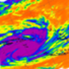
What you make of the infeed from TC Rusty in SW Vic David? Seems to be some rain out that way.. Did any of the models pick this up?
Re: Storms and rain Feb 25th-March 2nd.
The trough that is in the central region currently and associated wind change is not the cold front, the cold front is approaching and will come late today/tonight, you can see it on the satellite images quite clearly by the frontal cloud shape and then the small blobs of cloud indicating the cold air behind the front, so everything we get before the frontal connection of cold air with warm is a bonus to what may happen when warm air and cold air combine and create even more instability.
Keep watching the satellite image and watch the latest observations you will know when you see it.
Keep watching the satellite image and watch the latest observations you will know when you see it.
Re: Storms and rain Feb 25th-March 2nd.
Interesting too see all the small cells popping up over the bay and east melbourne, I think also that what you see down at portland and warnnabool may be the front starting to go overland but it could just be the connection of warm to cooler air. It's a multi-stage setup with the initial wind change which is already here in Geelong is not strong and does not feel that cool which changes it to sw then as it gets stronger as you can see down in the far west coast the direction is alot more southerly so perhaps the rain down that way is the start, when that catches up to whatever going on currently in the central region - warm air small cells, then it should be interesting.
- I_Love_Storms
- Supercell
- Reactions:
- Posts: 2812
- Joined: Wed Dec 02, 2009 2:01 pm
- Location: Hawthorn
Re: Storms and rain Feb 25th-March 2nd.
Far out!! It is looking like Feb 4 2011 with those diagonal bands of heavy rain and storms!
Re: Storms and rain Feb 25th-March 2nd.
Wilson's Prom could be bang in the firing line for one of those currentlyFar out!! It is looking like Feb 4 2011 with those diagonal bands of heavy rain and storms!
- Sean
- Supercell
- Reactions:
- Posts: 1001
- Joined: Mon Feb 27, 2012 6:35 pm
- Location: Patterson Lakes - SE Melb
Re: Storms and rain Feb 25th-March 2nd.
What I've found with storms coming over the bay from the nw, they always undergo mitosis and miss me in the se. The ne and down mornington way always get hit.
edit: more seem to be forming, i think
edit: more seem to be forming, i think
Last edited by Sean on Wed Feb 27, 2013 2:08 pm, edited 1 time in total.
-
Tempest
- Cumulonimbus
- Reactions:
- Posts: 148
- Joined: Sat Aug 14, 2010 8:34 pm
- Location: Warragul North, Vic... 140m asl
Re: Storms and rain Feb 25th-March 2nd.
Some nice rumbling here now and our first spots of rain for the day. Nothing heavy yet though.
Re: Storms and rain Feb 25th-March 2nd.
Feel like a kid waiting to open Christmas presents, fast forward one hour button please ... 
-
Tempest
- Cumulonimbus
- Reactions:
- Posts: 148
- Joined: Sat Aug 14, 2010 8:34 pm
- Location: Warragul North, Vic... 140m asl
Re: Storms and rain Feb 25th-March 2nd.
Absolutely pelting down now. Best rain since...a long time 

-
93ben
- Site Admin
- Reactions:
- Posts: 604
- Joined: Tue Dec 27, 2011 12:28 am
- Location: Templestowe, Victoria
- Contact:

Re: Storms and rain Feb 25th-March 2nd.
Got drenched in Templestowe while gardening. Didn't feel so bad as it hasn't rained for ages here like that! Loving (you need a love heart emotion) this rain  !
!
Btw when I went to TAFE in Glen Wavereley yesterday morning the traffic was so crazy because of the rain that it was gridlocked all the way from Donvale on springvale road. When I got up to Waverley road (where I turn right), the traffic lights were out and police were controlling the traffic which took for hours. I also noticed it flooding in the middle of springvale road.
At least we're finally getting rain. So much for the thunderstorms but I think rain is better atm so then it can put out the bushfires and not start more fires with lightning strikes.
- Skywalker
- Supercell
- Reactions:
- Posts: 1875
- Joined: Sun Nov 29, 2009 10:03 am
- Location: Burnside Heights/Cowes (Home) & Sunshine West (Work)
Re: Storms and rain Feb 25th-March 2nd.
A bit fat nothing here, that cell I mentioned earlier seemed to disappear.
Caroline Springs, Melbourne's meteorological boredom zone.