
Welcome New Members! We want to hear from you. Register, stop lurking and start posting!
Heat, rain, wind, thunder & lightning, etc. - Nov 24 to ???
- Wilko
- Supercell
- Reactions:
- Posts: 1492
- Joined: Wed Aug 11, 2010 12:08 pm
- Location: Moorabbin & Highett, Vic
Re: Heat, rain, wind, thunder & lightning, etc. - Nov 24 to
its a pity storms are moving so fast !!!
- WeatherViewer
- Cumulonimbus
- Reactions:
- Posts: 389
- Joined: Fri Oct 19, 2012 5:57 pm
- Location: Truganina
Re: Heat, rain, wind, thunder & lightning, etc. - Nov 24 to
Really hope to see some action in tonight. I was outside watching all the lighting strikes hit Ballarat, Geelong & Lara.
Seems to have completely dodged Wyndham Vale.
Seems to have completely dodged Wyndham Vale.
-
BigTom

- Cumulus
- Reactions:
- Posts: 84
- Joined: Tue May 22, 2012 9:01 pm
- Location: Caroline Springs, Victoria
Re: Heat, rain, wind, thunder & lightning, etc. - Nov 24 to
I missed the first storm as I was at work, only seen a couple of flashes after it passed. Hopefully the storms in the West make it here and still pack-a-punch 
- wolfcat
- Cumulonumbus Calvas
- Reactions:
- Posts: 562
- Joined: Sun Mar 07, 2010 12:14 pm
- Location: Bentleigh East
- Contact:
Re: Heat, rain, wind, thunder & lightning, etc. - Nov 24 to
Some really nice CG's over the bay, just downloading the shots now from the end of North Road
Heavy rain settled in, so time to empty the camera for later tonight.
Heavy rain settled in, so time to empty the camera for later tonight.
other places you will find me...
My blog...http://www.wolfcat.com.au/randomrants/
Flickr .. http://www.flickr.com/photos/wolfcat_aus/
Twitter... http://twitter.com/wolfcat
Redbubble... http://www.redbubble.com/people/wolfcat
My blog...http://www.wolfcat.com.au/randomrants/
Flickr .. http://www.flickr.com/photos/wolfcat_aus/
Twitter... http://twitter.com/wolfcat
Redbubble... http://www.redbubble.com/people/wolfcat
- sparra
- Cumulonimbus
- Reactions:
- Posts: 103
- Joined: Mon Aug 08, 2011 11:11 am
- Location: Netherby, via Nhill
Re: Heat, rain, wind, thunder & lightning, etc. - Nov 24 to
Haha.....we are still here but we 35km north of Nhill. Just had really bad wind and now heavy rain.....just what e don't need but exciting watching it anyway.....must post this before we loose power...stay safe everyone!!!
- Rhino
- Supercell
- Reactions:
- Posts: 1227
- Joined: Mon Nov 30, 2009 11:37 am
- Location: Carisbrook-Near Maryborough
Re: Heat, rain, wind, thunder & lightning, etc. - Nov 24 to
Will be interesting to see how close CMC comes to this by sat lunchtime, seems to line up nicely with the radar atm and seems the closest so far of the models...
http://www.weatherzone.com.au/models/?l ... 4&focus=mh
And starting to get a real wriggle on now on the 256km radar, watch this explode, hopefully.
Rhino.
http://www.weatherzone.com.au/models/?l ... 4&focus=mh
And starting to get a real wriggle on now on the 256km radar, watch this explode, hopefully.
Rhino.
- wolfcat
- Cumulonumbus Calvas
- Reactions:
- Posts: 562
- Joined: Sun Mar 07, 2010 12:14 pm
- Location: Bentleigh East
- Contact:
Re: Heat, rain, wind, thunder & lightning, etc. - Nov 24 to
Wonder if this will do as a lightning photo...
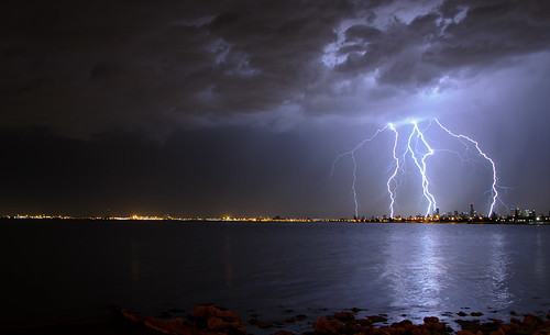
Taken 1 hour ago at the end of North Road.
Click for bigger version,
Taken 1 hour ago at the end of North Road.
Click for bigger version,
other places you will find me...
My blog...http://www.wolfcat.com.au/randomrants/
Flickr .. http://www.flickr.com/photos/wolfcat_aus/
Twitter... http://twitter.com/wolfcat
Redbubble... http://www.redbubble.com/people/wolfcat
My blog...http://www.wolfcat.com.au/randomrants/
Flickr .. http://www.flickr.com/photos/wolfcat_aus/
Twitter... http://twitter.com/wolfcat
Redbubble... http://www.redbubble.com/people/wolfcat
- Rhino
- Supercell
- Reactions:
- Posts: 1227
- Joined: Mon Nov 30, 2009 11:37 am
- Location: Carisbrook-Near Maryborough
Re: Heat, rain, wind, thunder & lightning, etc. - Nov 24 to
Yeah will probably do wolfcat, I've seen better...........in my dreams. Freakin great shot mate, absolute pearler, well done.
Rhino.
Rhino.
- Gordon
- Supercell
- Reactions:
- Posts: 2907
- Joined: Thu Jun 17, 2010 10:01 am
- Location: Near Gordon, Vic. 620 m asl
Re: Heat, rain, wind, thunder & lightning, etc. - Nov 24 to
Nice pic! Temp here 20 C, Ballarat DP 20.1 C!
- Rhino
- Supercell
- Reactions:
- Posts: 1227
- Joined: Mon Nov 30, 2009 11:37 am
- Location: Carisbrook-Near Maryborough
Re: Heat, rain, wind, thunder & lightning, etc. - Nov 24 to
16mm at Nhill so far so a good drop although probably not needed there at this stage.
Rhino.
Rhino.
- Lily
- Supercell
- Reactions:
- Posts: 4014
- Joined: Wed Nov 25, 2009 10:29 pm
- Location: Rowville/Lysterfield
Re: Heat, rain, wind, thunder & lightning, etc. - Nov 24 to
Bravo, Wolfcat! Lovely
- norwester
- Cumulonimbus
- Reactions:
- Posts: 105
- Joined: Sat Feb 05, 2011 9:54 am
- Location: Merbein, Vic
Re: Heat, rain, wind, thunder & lightning, etc. - Nov 24 to
Fantastic photo Wolfcat! One for the BOM calendar?
Dry, dusty and hot - usually!
Re: Heat, rain, wind, thunder & lightning, etc. - Nov 24 to
Awesome shot Wolfcat.
I swear I saw that bolt...amazing.
Highly inconvenient that the storms have to come in the early hours of the morning. But that's nature for you.
Hope to last til the next band to come through.
I swear I saw that bolt...amazing.
Highly inconvenient that the storms have to come in the early hours of the morning. But that's nature for you.
Hope to last til the next band to come through.
- MasterOfRoc
- Cumulus
- Reactions:
- Posts: 58
- Joined: Fri Sep 03, 2010 4:47 pm
- Location: St Arnaud, VIC
Re: Heat, rain, wind, thunder & lightning, etc. - Nov 24 to
Storms starting to come through St Arnaud now... bit of a sound and light show... unfortunately i can't get out with the Camera, much to my disgust 
Also, Wolf, for some reason i can't seem to see Flikr photo's on our home broadband, any chance of re-posting with an alternate host? Sounds like im missing an amazing shot
Also, Wolf, for some reason i can't seem to see Flikr photo's on our home broadband, any chance of re-posting with an alternate host? Sounds like im missing an amazing shot
-
BigTom
- Cumulus
- Reactions:
- Posts: 84
- Joined: Tue May 22, 2012 9:01 pm
- Location: Caroline Springs, Victoria
Re: Heat, rain, wind, thunderf & lightning, etc. - Nov 24 to
Huge Orange blob just west of the Vic/NSW/SA border near Mildura :O
-
Instability

- Cumulonimbus
- Reactions:
- Posts: 290
- Joined: Thu Nov 26, 2009 6:26 am
- Location: Live in Burwood - Work in Dandenong South
Re: Heat, rain, wind, thunder & lightning, etc. - Nov 24 to
Hmmm, contemplating putting the camera gear in the car and working out an intercept point....any suggestions?
Rog.
Rog.
-
mad*moo73

- Cumulonumbus Calvas
- Reactions:
- Posts: 637
- Joined: Mon Mar 08, 2010 2:11 pm
- Location: Keysborough
Re: Heat, rain, wind, thunder & lightning, etc. - Nov 24 to
Oh Wolfcat you only got half a dozen bolts in that photo must be getting slack in your old age!!!!!! 
As for here not much happening a couple of rumbles one that went on for around a minute I reckon & some rain.
As for here not much happening a couple of rumbles one that went on for around a minute I reckon & some rain.
Double Whopper award winning footy tipper!!!!!!!!!!!!!!
-
BigTom
- Cumulus
- Reactions:
- Posts: 84
- Joined: Tue May 22, 2012 9:01 pm
- Location: Caroline Springs, Victoria
Re: Heat, rain, wind, thunder & lightning, etc. - Nov 24 to
Flashes now visible to the west! going to be a good lightshow
Re: Heat, rain, wind, thunder & lightning, etc. - Nov 24 to
Good storms still firing, coming through Melbourne within about 90 minutes. Black core near mt mercer! dont fall asleep yet hahaha
Go the bombersss!
- wolfcat
- Cumulonumbus Calvas
- Reactions:
- Posts: 562
- Joined: Sun Mar 07, 2010 12:14 pm
- Location: Bentleigh East
- Contact:
Re: Heat, rain, wind, thunder & lightning, etc. - Nov 24 to
SEVERE THUNDERSTORM WARNING
for DAMAGING WIND, HEAVY RAINFALL and LARGE HAILSTONES
For people in the Central, Mallee, Wimmera and parts of the South West, Northern Country, North Central and West and South Gippsland Forecast Districts.
Issued at 12:12 am Saturday, 1 December 2012.
Severe thunderstorms are likely to produce damaging winds, heavy rainfall that may lead to flash flooding and large hailstones in the warning area over the next several hours. Locations which may be affected include Mildura, Horsham, Ballarat, Maryborough, Geelong and Melbourne.
The next warning is due to be issued by 3:15 am.
other places you will find me...
My blog...http://www.wolfcat.com.au/randomrants/
Flickr .. http://www.flickr.com/photos/wolfcat_aus/
Twitter... http://twitter.com/wolfcat
Redbubble... http://www.redbubble.com/people/wolfcat
My blog...http://www.wolfcat.com.au/randomrants/
Flickr .. http://www.flickr.com/photos/wolfcat_aus/
Twitter... http://twitter.com/wolfcat
Redbubble... http://www.redbubble.com/people/wolfcat