It is freezing up here at the mo, 3.5C under mist, spitting sleet and breezy.

Welcome New Members! We want to hear from you. Register, stop lurking and start posting!
Cold Fronts: August 22 - 26
- Macedonian
- Supercell
- Reactions:
- Posts: 2341
- Joined: Mon Dec 21, 2009 10:44 pm
- Location: Mount Macedon Vic at 870m above sea level
Re: Cold Fronts: August 22 - 26
It was snowing on Mt Macedon this morning stratospear. Last night was our first night in our new house up on the mount. We moved in yesterday afternoon during a hail storm and i woke up early this morning to see snowfalling. Nice to lie in bed with a cuppa and watch the snow. It was on and off from 6am to about 9am, no settling just flurries. Was a brilliant welcome to mountain living. Bloody cold though  and muddy
It is freezing up here at the mo, 3.5C under mist, spitting sleet and breezy.
It is freezing up here at the mo, 3.5C under mist, spitting sleet and breezy.
Home- "Shepherd's Bush" at Mt Macedon. 870m
Work- "Bolobek" at Macedon. 430m
Work- "Bolobek" at Macedon. 430m
- Lily
- Supercell
- Reactions:
- Posts: 4014
- Joined: Wed Nov 25, 2009 10:29 pm
- Location: Rowville/Lysterfield
Re: Cold Fronts: August 22 - 26
Hey, congrats on finally getting into your new home Macedonian. Feels like forever, bet you're elated to finally be in and what an awesome weather welcome! Where's the pics (hint, hint!).
Not much to report here, just a bit of rain, no hail, pretty cold. Just back from shopping, car temp gauge was hovering around the 9 & 10 degree mark.
Not much to report here, just a bit of rain, no hail, pretty cold. Just back from shopping, car temp gauge was hovering around the 9 & 10 degree mark.
- Macedonian
- Supercell
- Reactions:
- Posts: 2341
- Joined: Mon Dec 21, 2009 10:44 pm
- Location: Mount Macedon Vic at 870m above sea level
Re: Cold Fronts: August 22 - 26
Thanks Lily, i will put some pics up soon, im not real good at it. My phone wouldnt capture the snow this morning, useless ol nokia.time for an update!
Home- "Shepherd's Bush" at Mt Macedon. 870m
Work- "Bolobek" at Macedon. 430m
Work- "Bolobek" at Macedon. 430m
- Skywalker
- Supercell
- Reactions:
- Posts: 1876
- Joined: Sun Nov 29, 2009 10:03 am
- Location: Burnside Heights/Cowes (Home) & Sunshine West (Work)
Re: Cold Fronts: August 22 - 26
Get yourself a Nokia 808 pureview. Best camera phone on the market, and is perfect for taking those weather event moments.Macedonian » Fri Aug 24, 2012 2:56 pm wrote:Macedonian wrote:Thanks Lily, i will put some pics up soon, im not real good at it. My phone wouldnt capture the snow this morning, useless ol nokia.time for an update!
Been very windy here with virtually no rain all day. Going to be an interesting ride home heading straight into those North Westerly winds.
Caroline Springs, Melbourne's meteorological boredom zone.
- aussiestormfreak
- Cumulonumbus Calvas
- Reactions:
- Posts: 534
- Joined: Thu Feb 03, 2011 9:52 am
- Location: Melbourne, Corryong, Merimbula, and Fiji
- Contact:
Re: Cold Fronts: August 22 - 26
Gday everyone! Sorry that it's been a while since I've posted, not much to contribute lately and I've been so busy 
The past few days sure have been wild, a sign that we're now moving into the early stages of the spring/summer period when Victoria's weather can turn erratic, even potentially dangerous, as cold air from the south collides with increasingly hot air from up north
I was at Federation Square for the Victorian Welcome Home event for the Australian Olympic Team on Wednesday. Despite the gusty northerlies and the chill, I couldn't help noticing how warm the Sun. Checking the Bureau of Meteorology and Weatherzone websites after I returned to RMIT University, I was so happy when I saw that Melbourne has had its first 20C+ maximum in 13 weeks (21.2C at about 2PM in the City, 21.8C at my house)... Milestone Number 1 for the Warm Season of 2012-2013
And yes Storm Season 2012-2013 is up-and-running. I caught the rainy remnants of a thunderstorm on the night of July 12th-13th 2012 while up in Corryong, but the thunder and lightning stopped well before the storm reached me - still, as far as I'm concerned, that's Storm Number 1 for the season.
Yesterday's storm here in Melbourne (Storm Number 2) would have to be one of the best 'non-cold air' winter thunderstorms I've seen - the best such 'warm-season style' winter thunderstorm for me would have to be July 23rd 2006 (two to three hours of torrential rain, pea-sized hail, lots of lightning including at least three dangerously close CGs in that storm).
I couldn't believe how massive and well-defined some of the cumulonimbus clouds were yesterday, and the amount of clear air there was ahead of the squall line, brought back memories of the November 9th 2011 when the resulting supercell thunderclouds must've been punching 40,000 feet or more, I doubt yesterday's storm clouds were THAT big, but seriously they were very impressive, especially for winter
Good thing the storm passed just as I was leaving for a dinner out in Northcote, otherwise I would've had to wait in the rain and lightning at the bus stop. At least I was treated to a gorgeous rainbow when the Sun came out. Plenty more showers and thunderstorms during the train trip from Belgrave to the City but thankfully the activity died off just as I got off at Parliament around 6:30PM to take the 86 RMIT Bundoora Tram to Northcote. The tram was delayed due to traffic congestion from the rain apparently, any reports of flooding and/or wind damage?
I don't have too many pics of yesterday's weather unfortunately as I was busy all day, but what I do have will be on my Flickr soon. Oh and I should mention that there was a beautiful sunrise yesterday morning!
2.1mm of rain at 9AM today, bringing my August 2012 total to 92.7mm. Currently at a rather raw 9.7C
The past few days sure have been wild, a sign that we're now moving into the early stages of the spring/summer period when Victoria's weather can turn erratic, even potentially dangerous, as cold air from the south collides with increasingly hot air from up north
I was at Federation Square for the Victorian Welcome Home event for the Australian Olympic Team on Wednesday. Despite the gusty northerlies and the chill, I couldn't help noticing how warm the Sun. Checking the Bureau of Meteorology and Weatherzone websites after I returned to RMIT University, I was so happy when I saw that Melbourne has had its first 20C+ maximum in 13 weeks (21.2C at about 2PM in the City, 21.8C at my house)... Milestone Number 1 for the Warm Season of 2012-2013
And yes Storm Season 2012-2013 is up-and-running. I caught the rainy remnants of a thunderstorm on the night of July 12th-13th 2012 while up in Corryong, but the thunder and lightning stopped well before the storm reached me - still, as far as I'm concerned, that's Storm Number 1 for the season.
Yesterday's storm here in Melbourne (Storm Number 2) would have to be one of the best 'non-cold air' winter thunderstorms I've seen - the best such 'warm-season style' winter thunderstorm for me would have to be July 23rd 2006 (two to three hours of torrential rain, pea-sized hail, lots of lightning including at least three dangerously close CGs in that storm).
I couldn't believe how massive and well-defined some of the cumulonimbus clouds were yesterday, and the amount of clear air there was ahead of the squall line, brought back memories of the November 9th 2011 when the resulting supercell thunderclouds must've been punching 40,000 feet or more, I doubt yesterday's storm clouds were THAT big, but seriously they were very impressive, especially for winter
No stormshield in the Belgrave area where I live, yet another direct/near-direct hit for me. The storm only lasted approximately 10-20 minutes, and the rain was nowhere near as heavy as it was on April 22nd 2012 so no problems with blocked, leaking gutters this time round, a bit of gusty wind and some small (pea-sized) hail too, plus one very close CG and almost-instantaneous thunderclap.Geoff » Thu Aug 23, 2012 5:24 pm wrote:Geoff wrote:Looks like we've got a new stormshield happening at Mt. Dandenong, it's splitting and going either side!!!
Good thing the storm passed just as I was leaving for a dinner out in Northcote, otherwise I would've had to wait in the rain and lightning at the bus stop. At least I was treated to a gorgeous rainbow when the Sun came out. Plenty more showers and thunderstorms during the train trip from Belgrave to the City but thankfully the activity died off just as I got off at Parliament around 6:30PM to take the 86 RMIT Bundoora Tram to Northcote. The tram was delayed due to traffic congestion from the rain apparently, any reports of flooding and/or wind damage?
I don't have too many pics of yesterday's weather unfortunately as I was busy all day, but what I do have will be on my Flickr soon. Oh and I should mention that there was a beautiful sunrise yesterday morning!
2.1mm of rain at 9AM today, bringing my August 2012 total to 92.7mm. Currently at a rather raw 9.7C
Online
- Gordon
- Supercell
- Reactions:
- Posts: 2909
- Joined: Thu Jun 17, 2010 10:01 am
- Location: Near Gordon, Vic. 620 m asl
Re: Cold Fronts: August 22 - 26
Only another 2 mm here so far today which is surprising given it's seemed quite showery - maybe the rain is blowing straight over the top of the rain gauge!
-
Australis(Shell3155)

- Supercell
- Reactions:
- Posts: 3148
- Joined: Mon Nov 30, 2009 8:05 pm
- Location: FTG
- Contact:
Re: Cold Fronts: August 22 - 26
Looking forward to seeing some photo's and congratulations on the new Home How exciting and snow to top it off.Macedonian » Fri Aug 24, 2012 12:41 pm wrote:Macedonian wrote:It was snowing on Mt Macedon this morning stratospear. Last night was our first night in our new house up on the mount. Bloody cold though
-
93ben
- Site Admin
- Reactions:
- Posts: 604
- Joined: Tue Dec 27, 2011 12:28 am
- Location: Templestowe, Victoria
- Contact:

Re: Cold Fronts: August 22 - 26
Hi everyone,
Here's my photos of the storm that hit Melbourne Yesterday. http://www.facebook.com/media/set/?set= ... 53ec3bf2e6" onclick="window.open(this.href);return false; I've set them to public, so anyone should be able to see them (even if you're not on Facebook).
Here's my photos of the storm that hit Melbourne Yesterday. http://www.facebook.com/media/set/?set= ... 53ec3bf2e6" onclick="window.open(this.href);return false; I've set them to public, so anyone should be able to see them (even if you're not on Facebook).
- Lily
- Supercell
- Reactions:
- Posts: 4014
- Joined: Wed Nov 25, 2009 10:29 pm
- Location: Rowville/Lysterfield
Re: Cold Fronts: August 22 - 26
Gee, you had heaps of hail there compared to us here! We had nothing like that, just a few pinging off the picnic table here and there lol
- Geoff
- Supercell
- Reactions:
- Posts: 2538
- Joined: Tue Jul 05, 2011 9:46 pm
- Location: Olinda VIC (470m ASL)
Re: Cold Fronts: August 22 - 26
So apart from that Chris, has anything of note happened in the last day or so?Macedonian wrote:Last night was our first night in our new house up on the mount. We moved in yesterday afternoon during a hail storm and i woke up early this morning to see snowfalling.
AWF Rainfall Details - Monthly rainfall stats. Please post your totals here at the end of each month, thank you –
http://www.theaustralianweatherforum.co ... &start=180
http://www.theaustralianweatherforum.co ... &start=180
-
mick

- Supercell
- Reactions:
- Posts: 1453
- Joined: Mon Nov 30, 2009 6:45 pm
- Location: Mid North SA Baaaaaaaaaaaaaaa
Re: Cold Fronts: August 22 - 26
A littler version of yesterday arvo with just the rain, wind and a beautiful rainbow. Squally now 70kph.
Onion weed I have studied.
It sends down a root, forms a bulb,sends down a root, forms another bulb.
The record for me was a string of bulbs, one every 4 inches or so. The form just below trowel level, very clever. Now the hole was 4 feet deep, thats a string of whatsit 12 bulbs. Now each bulb contains multiples of nine mini bulbs from nine to a max of 36 depending on its age. So each stem of onion weed you pull out can have from err 108 to 436 individual little bombs attached to it waiting to go off.
The good news is that you will have a cheap hobby for life.
-
Australis(Shell3155)
- Supercell
- Reactions:
- Posts: 3148
- Joined: Mon Nov 30, 2009 8:05 pm
- Location: FTG
- Contact:
Re: Cold Fronts: August 22 - 26
Noticed a good photo on facebook of a road covered in Hail, Im presuming it was Emerald Cockatoo direction from last night.
- aussiestormfreak
- Cumulonumbus Calvas
- Reactions:
- Posts: 534
- Joined: Thu Feb 03, 2011 9:52 am
- Location: Melbourne, Corryong, Merimbula, and Fiji
- Contact:
Re: Cold Fronts: August 22 - 26
Cold and windy with lots of showers today (no hail though), 3.2mm since 9AM bringing my August 2012 total to 95.9mm... almost at the 100mm mark
I got to briefly see and photograph a stunning double rainbow at around 5:20PM as the Sun came out following a heavy shower, a nice treat on a day that was otherwise better spent indoors
I got to briefly see and photograph a stunning double rainbow at around 5:20PM as the Sun came out following a heavy shower, a nice treat on a day that was otherwise better spent indoors
-
typhoon29

- Cumulonumbus Calvas
- Reactions:
- Posts: 510
- Joined: Fri Jan 01, 2010 11:05 pm
- Location: Ballarat (Mitchell Park)
- Contact:
Re: Cold Fronts: August 22 - 26
windy day here, 3mm of showers. The bulk of the goods went through Bass Straight. Next event Wednesday, similar show???? Lining up as one of the wettest winters for a while. 136,108, ~80mm at the moment. Last Winter 47,83 56mm.
Ballarat, Home of the Anti-Thunderstorm Shield!
-
crikey

- Supercell
- Reactions:
- Posts: 1314
- Joined: Mon Feb 07, 2011 8:02 pm
- Location: tweed shire NSW and nDUNOLLY.. Nth Central district VIC
- Contact:
Re: Cold Fronts: August 22 - 26
Cold and sometimes wet and windy here today
Some great reports of snow falls on the VIC snow fields
Livinia ch 9 news said Falls creek had 100mm in one week
The ski forum is reporting good falls especially at Mt hotham as well
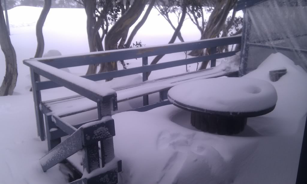
Here is a snap from Mt hotham from the forum
http://forums.ski.com.au/forums/ubbthre ... 35&page=11" onclick="window.open(this.href);return false;
Some great reports of snow falls on the VIC snow fields
Livinia ch 9 news said Falls creek had 100mm in one week
The ski forum is reporting good falls especially at Mt hotham as well
Here is a snap from Mt hotham from the forum
http://forums.ski.com.au/forums/ubbthre ... 35&page=11" onclick="window.open(this.href);return false;
- Geoff
- Supercell
- Reactions:
- Posts: 2538
- Joined: Tue Jul 05, 2011 9:46 pm
- Location: Olinda VIC (470m ASL)
Re: Cold Fronts: August 22 - 26
Well, well, well! Blue sky and sunshine on a Saturday morning? I can't believe it! I'm off out into the garden to make hay while the sun shines, and I won't be back until it's raining again!
AWF Rainfall Details - Monthly rainfall stats. Please post your totals here at the end of each month, thank you –
http://www.theaustralianweatherforum.co ... &start=180
http://www.theaustralianweatherforum.co ... &start=180
-
Rivergirl

- Memorial
- Reactions:
- Posts: 3674
- Joined: Sun Nov 22, 2009 6:04 pm
- Location: Ferny Creek VIC
- Contact:
Re: Cold Fronts: August 22 - 26
Have fun making hay Geoff
Wow thats a nice lot of snow there crikey. Nice pics there Ben. Macedonian I can't think of anything better than waking up to snow in your new house aussiestormfreak that would have been cool to see the athletes. I remember going in 2000 after the Sydney Olympics.
Wow thats a nice lot of snow there crikey. Nice pics there Ben. Macedonian I can't think of anything better than waking up to snow in your new house
- HarleyB
- Cumulonumbus Calvas
- Reactions:
- Posts: 839
- Joined: Sun Oct 10, 2010 9:39 pm
- Location: Wangaratta
Re: Cold Fronts: August 22 - 26
We got a surprising 7mm here for the week, whereas the Mangalore Airport station only got 2.6mm over the same period. The ground is soaked just like it was this time two years ago. Hoping we don't get the big one soon.
Re: Cold Fronts: August 22 - 26
another 8mm rain yesterday. MTD 67mm ave. is 95mm really hoping we do not make it.
- aussiestormfreak
- Cumulonumbus Calvas
- Reactions:
- Posts: 534
- Joined: Thu Feb 03, 2011 9:52 am
- Location: Melbourne, Corryong, Merimbula, and Fiji
- Contact:
Re: Cold Fronts: August 22 - 26
It sure was RivergirlRivergirl » Sat Aug 25, 2012 11:25 am wrote:Rivergirl wrote:Have fun making hay Geoff
Wow thats a nice lot of snow there crikey. Nice pics there Ben. Macedonian I can't think of anything better than waking up to snow in your new house
3.2mm at 9AM today... was expecting a lot more given how heavy some of the showers were yesterday but then again they were brief, localised and fast-moving