As Ken's post mentions...(cut n paste from NQ area thread)
To note: A tropical LOW crossed the CYP(Cape York) lastnight/this morning and now lies in the Coral Sea off Cairns(I say near Willis Is. to the SW), currently creating large falls over the North Qld coatline, expected rainfall max tonight of 130mm+ for areas that recieve the most favourable outcome weatherwise(dependant on where convergence maximum lies). The system currently looking a little tired and weak with no real southerly development occuring(Looks like half a system), is expected however to intesnify over the coming 24-48 hours and may be named beyond that(will be TC Jasmine if she can strengthen). A few areas of dry air pushing toward it currently that may become a problem in the longer term should they impact the systems moist feed. Will track SE(ESE) away from the QLD coastline(I never like to say 100% on something like that so keep an eye on the BOM pages for any warnings or change in that track scenario!).

Welcome New Members! We want to hear from you. Register, stop lurking and start posting!
Wet Season 2011/2012 - Queensland
-
Thunder

- Cumulonimbus
- Reactions:
- Posts: 405
- Joined: Sun May 01, 2011 4:05 pm
- Location: Kelso, Townsville. NQ- the sunny upper ross!
Re: Wet Season 2011/2012 - Queensland
You're only as happy as you choose to be....I choose to be miserable! 
Rainfall Townsville 2013
Jan-301.6(276.4) Feb-63.6(307.1)
YTD-365.2(1150.9)
Rainfall 2012
Rainfall Townsville 2013
Jan-301.6(276.4) Feb-63.6(307.1)
YTD-365.2(1150.9)
Rainfall 2012
-
crikey

- Supercell
- Reactions:
- Posts: 1314
- Joined: Mon Feb 07, 2011 8:02 pm
- Location: tweed shire NSW and nDUNOLLY.. Nth Central district VIC
- Contact:
Re: Wet Season 2011/2012 - Queensland
I was looking at WATL wind forecast for the coming week and found that there is a persistent flow of southerlies for pretty much the rest of the week
I took a snap from one of many days indicating this apparent cooling pattern over the entire continent. I found it interesting that it reaches right up into the monsoon trough and maybe the Inter Tropical Convergence Zone( ITCZ) for quite a few days
I have never seen southerlies over the generally the entire continent in particular summer. Not that l have that many years taking notice
Just posing a question
How will this flow of cooler southerlies likely to effect the monsoon trough. Will it make more cloud in the tropics?
and will it hinder cyclone development?
Will that deliver cooler temps to the tropics?
Thought this was the best of the picks for weather watching this week
source:
http://www.bom.gov.au/jsp/watl/wind/index.jsp" onclick="window.open(this.href);return false;
Re: Wet Season 2011/2012 - Queensland
It looks like the next 3 or so weeks may become spectacularly quiet across much of our tropics except the far northeast.
The forecast MJO diagram from the EC ensemble currently shows a clear eastward movement of the current active MJO phase away from our continent. This also appears to be reflected by the strong dry signal spreading across much of the tropics in the Week 2 guidance (from about the 11th Feb through mid Feb) from various ensembles (>25mm precip probabilities from the North American Ensemble Forecast System, and precip anomalies from the NCEP ensemble). The EC ensemble is also still suggesting a continuation of overall cool anomalies over much of NSW, SE QLD and eastern Vic over the next few weeks.
I also made a post touching on this under the SE Australia rainfall thread at:
http://www.theaustralianweatherforum.co ... p?f=3&t=28" onclick="window.open(this.href);return false;
EDIT: Below is the latest output from the GFS ensemble for TC Jasmine. The high confidence in its eastward track as indicated by the narrow spread of the ensemble's individual forecast members is in general agreement with others such as the EC ensemble:
Re: Wet Season 2011/2012 - Queensland
Hmmm for some reason, the GFS ensemble forecast I uploaded in my previous post the other day doesn't show up properly anymore. Here it is again:

-
Thunder
- Cumulonimbus
- Reactions:
- Posts: 405
- Joined: Sun May 01, 2011 4:05 pm
- Location: Kelso, Townsville. NQ- the sunny upper ross!
Re: Wet Season 2011/2012 - Queensland
small chance of a Tropical LOW forming in the Coral Sea trough over the weekend, not a very high chance though, hopefully things will be picking up over Northern QLD over the coming weeks as the MJO moves into our region and the monsoon possibly returns, currently though looking like it's the North and West's turn for now! Half their luck...
You're only as happy as you choose to be....I choose to be miserable!
Rainfall Townsville 2013
Jan-301.6(276.4) Feb-63.6(307.1)
YTD-365.2(1150.9)
Rainfall 2012
Rainfall Townsville 2013
Jan-301.6(276.4) Feb-63.6(307.1)
YTD-365.2(1150.9)
Rainfall 2012
-
Thunder
- Cumulonimbus
- Reactions:
- Posts: 405
- Joined: Sun May 01, 2011 4:05 pm
- Location: Kelso, Townsville. NQ- the sunny upper ross!
Re: Wet Season 2011/2012 - Queensland
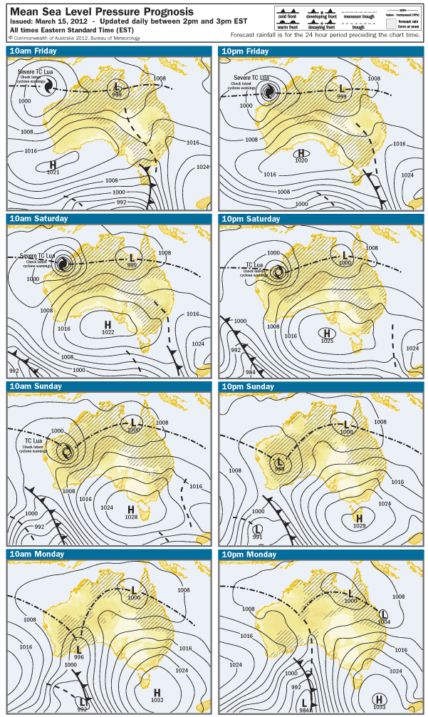
Still a chance on that LOW for the weekend, the GOC has another LOW progged that is the remanants of TD 96P that crossed the NT border earlier this week! Here's the BOM 4 day chart. looking oh so good for QLD!!!
EDIT: forgot to add...
IDQ20032
Australian Government Bureau of Meteorology
Queensland
TOP PRIORITY FOR IMMEDIATE BROADCAST
SEVERE WEATHER WARNING
for Heavy Rainfall and Abnormally High Tides
For people in parts of the Peninsula and Gulf Country districts.
Issued at 4:15 pm on Thursday 15 March 2012
Synoptic Situation: At 4:00pm AEST, the monsoon trough lies over the southern
Gulf of Carpentaria. The trough is expected to strengthen while a low currently
over the Northern Territory may move over southern Gulf of Carpentaria waters on
the weekend.
Heavy rainfall that may lead to flash flooding is expected to develop on Friday
and continue over the weekend about the Gulf of Carpentaria coast and adjacent
inland areas between Torres Strait and the Northern Territory border. Localised
24 hour totals in excess of 150mm are likely.
Water levels on the high tide could exceed the highest tide of the year over the
next few days about the Gulf of Carpentaria coast and Torres Strait Islands.
Locations which may be affected include the Torres Strait Islands, Weipa,
Kowanyama, Normanton, Burketown and Mornington Island.
Emergency Management Queensland advises that people should:
* Avoid driving, walking or riding through flood waters.
* Keep clear of creeks and storm drains.
* If near the coastline, stay well away from the water's edge.
* For emergency assistance contact the SES on 132 500.
The next warning is due to be issued by 11:00 pm AEST Thursday.
Warnings are also available through TV and Radio broadcasts, the Bureau's
website at http://www.bom.gov.au" onclick="window.open(this.href);return false; or call 1300 659 219. The Bureau and Emergency
Management Queensland would appreciate warnings being broadcast regularly.
You're only as happy as you choose to be....I choose to be miserable!
Rainfall Townsville 2013
Jan-301.6(276.4) Feb-63.6(307.1)
YTD-365.2(1150.9)
Rainfall 2012
Rainfall Townsville 2013
Jan-301.6(276.4) Feb-63.6(307.1)
YTD-365.2(1150.9)
Rainfall 2012
-
crikey
- Supercell
- Reactions:
- Posts: 1314
- Joined: Mon Feb 07, 2011 8:02 pm
- Location: tweed shire NSW and nDUNOLLY.. Nth Central district VIC
- Contact:
Re: Wet Season 2011/2012 - Queensland
I think the wet season closes end of April and precipitation should start to recede
The rainfall totals here suggest that the season finished last month
twas a relatively dry april
Maybe dry season and winter starting early??

the past 6 months
Overall , it would seem ,the monsoon season delivered generously in most parts

The rainfall totals here suggest that the season finished last month
twas a relatively dry april
Maybe dry season and winter starting early??
the past 6 months
Overall , it would seem ,the monsoon season delivered generously in most parts