
Welcome New Members! We want to hear from you. Register, stop lurking and start posting!
Vic - Potential showers/storms - 21st Dec to Boxing Day 2011
Re: Vic - Potential showers/storms - 21st Dec to Boxing Day
Preety much what I thought Storms tracking ENE Today
Re: Vic - Potential showers/storms - 21st Dec to Boxing Day
GFS 00z just updated and remains almost indentical.. Infact has for the past 8 to 9 runs now
-
flatcam
- Cumulonimbus
- Reactions:
- Posts: 182
- Joined: Wed Jan 05, 2011 8:16 pm
- Location: Craigieburn, Victoria
Re: Vic - Potential showers/storms - 21st Dec to Boxing Day
I've been watching the towers go up for most of the day here. They have been quite impressive! It looks as if we could be directly in the line of anything that develops here so hopefully this afternoon should be interesting! 
That chart at the bottom of the page looks good!
Cheers, Cam
That chart at the bottom of the page looks good!
Cheers, Cam
- aussiestormfreak
- Cumulonumbus Calvas
- Reactions:
- Posts: 534
- Joined: Thu Feb 03, 2011 9:52 am
- Location: Melbourne, Corryong, Merimbula, and Fiji
- Contact:
Re: Vic - Potential showers/storms - 21st Dec to Boxing Day
Peaked at 37.6C on my thermometer a little while ago, and it certainly felt like it, OUCH!!!  Just came back from a little walk with my girlfriend to the local shop to get some milk and an ice cream, very convective out there (took a few pics of the cells that affected the Wallan, Kinglake, Healesville, Marysville, Warburton, and Noojee areas over the past few hours... surprised that no STW was issued), 50/50 chance that a shower or thunderstorm will pop up here in the Dandenong Ranges over the next hour or two...
- droughtbreaker
- Supercell
- Reactions:
- Posts: 2844
- Joined: Wed Nov 25, 2009 7:50 pm
- Location: Mount Macedon, VIC, 520m asl
Re: Vic - Potential showers/storms - 21st Dec to Boxing Day
A few rumbles of thunder here as some localised development is taking place on the sea breeze front. I doubt much will get going today but the next two days look interesting.
EDIT: Highest in the state today is Mildura at just under 36C. 31C for most of Melbourne and we have got to 29C here but now down to 27C. The humidity makes it feel a little warmer than it actually is. Melbourne is a shocker on these sort of days though with all the artificial heat bouncing off every surface. It was a massive relief to get home into more pleasant conditions.
EDIT: Highest in the state today is Mildura at just under 36C. 31C for most of Melbourne and we have got to 29C here but now down to 27C. The humidity makes it feel a little warmer than it actually is. Melbourne is a shocker on these sort of days though with all the artificial heat bouncing off every surface. It was a massive relief to get home into more pleasant conditions.

Re: Vic - Potential showers/storms - 21st Dec to Boxing Day
Currently in Narracan in Gippsland, can see that storm in the east, its a pretty impressive mass of convection from my vantage point.
- I_Love_Storms
- Supercell
- Reactions:
- Posts: 2812
- Joined: Wed Dec 02, 2009 2:01 pm
- Location: Hawthorn
Re: Vic - Potential showers/storms - 21st Dec to Boxing Day
Latest ec just upped the ante big time progging 30mm here on Sunday night. This obviously doesnt take into account additional falls likely with any isolated severe cells
Re: Vic - Potential showers/storms - 21st Dec to Boxing Day
Huge convection to the NE!!
EDIT: Just checked the radar and it looks intense! (Red cores)
EDIT: Just checked the radar and it looks intense! (Red cores)
Go the bombersss!
-
AUS_Twisted

- Storm Chaser
- Reactions:
- Posts: 652
- Joined: Wed Nov 25, 2009 6:15 pm
- Location: Dandenong North, Melb
Re: Vic - Potential showers/storms - 21st Dec to Boxing Day
That cell is struggling to hold, been watching that area for awhile off and on
From 30 mins ago and now there's a weakish looking anvil
From 30 mins ago and now there's a weakish looking anvil
- Attachments
-
- IMG_0409.jpg (80.41 KiB) Viewed 6953 times
Re: Vic - Potential showers/storms - 21st Dec to Boxing Day
well today was rather a letdown...hope the next few days are better!
-
Instability

- Cumulonimbus
- Reactions:
- Posts: 290
- Joined: Thu Nov 26, 2009 6:26 am
- Location: Live in Burwood - Work in Dandenong South
Re: Vic - Potential showers/storms - 21st Dec to Boxing Day
So, didn't enjoy watching the development of numerous single-updraft towers and anvils forming all over the place hey?James » Fri Dec 23, 2011 8:19 pm wrote:James wrote:well today was rather a letdown...hope the next few days are better!
I thought the day delivered much more eye-candy than most of us were expecting
Rog.
-
thunderhead

- Cumulus
- Reactions:
- Posts: 55
- Joined: Mon Apr 12, 2010 7:52 pm
- Location: Camberwell East
- Contact:
Re: Vic - Potential showers/storms - 21st Dec to Boxing Day
Been drinking champagne with my neighbour - good Christmas Cheer. Have I missed anything? LOL
East Camberwell - storm free zone
Re: Vic - Potential showers/storms - 21st Dec to Boxing Day
I couldnt see much here other than some "fine weather" convective cloud, overhead for a few hours which then dissolved by evening...
the cicadas are very loud tonight and its very muggy...
the cicadas are very loud tonight and its very muggy...
- aussiestormfreak
- Cumulonumbus Calvas
- Reactions:
- Posts: 534
- Joined: Thu Feb 03, 2011 9:52 am
- Location: Melbourne, Corryong, Merimbula, and Fiji
- Contact:
Re: Vic - Potential showers/storms - 21st Dec to Boxing Day
Was great to see showers and thunderstorms around the place again, even if they didn't reach my area... but good to have something to watch and photograph
Hope the Christmas weekend brings more widespread, more intense storm activity...
Hope the Christmas weekend brings more widespread, more intense storm activity...
Re: Vic - Potential showers/storms - 21st Dec to Boxing Day
A few thunderstorms around this afternoon we had 2.5mm rain off the edge of one.
-
daviescr

- Supercell
- Reactions:
- Posts: 1394
- Joined: Wed Dec 02, 2009 5:40 pm
- Location: Warranwood, Vic
Re: Vic - Potential showers/storms - 21st Dec to Boxing Day
Agreed, loved watching things explode this afternoon, so much potential around. Even had a single, fat drop of rain on my car window at around 4.30pmSo, didn't enjoy watching the development of numerous single-updraft towers and anvils forming all over the place hey?
I thought the day delivered much more eye-candy than most of us were expecting
Rog.
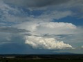
Stunning looking anvil out to the North East at that time too:

- I_Love_Storms
- Supercell
- Reactions:
- Posts: 2812
- Joined: Wed Dec 02, 2009 2:01 pm
- Location: Hawthorn
Re: Vic - Potential showers/storms - 21st Dec to Boxing Day
Next couple of days look way better. Central will get hammered.
Re: Vic - Potential showers/storms - 21st Dec to Boxing Day
Latest GFS is a lot more inclusive of the western half of the state on Christmas Day and has the bullseye hovering over Melbourne/Central areas tomorrow.
Looking forward to seeing what transpires.
Looking forward to seeing what transpires.
- Jake Smethurst
- Supercell
- Reactions:
- Posts: 3583
- Joined: Mon Nov 23, 2009 8:49 pm
- Location: Cheltenham
Re: Vic - Potential showers/storms - 21st Dec to Boxing Day
Yes noticed a few runs back that GFS was slowly edging the trough back and back and making it slower and slower. Continues to do so with tonights model runs, will be interesting, looks like much of western Victoria, bar the very far southwest corner in with a thunderstorm risk on Christmas Day now. Wonder if GFS will continue to hold back the trough, which means all areas will be under threat of showers/storms. Something to watch. I've updated AWF forecasts as well. Will do next update in morning before work.Meso » Fri Dec 23, 2011 11:27 pm wrote:Meso wrote:Latest GFS is a lot more inclusive of the western half of the state on Christmas Day and has the bullseye hovering over Melbourne/Central areas tomorrow.
Jake - Senior AWF Forecaster
Feel free to send me a private message if you have any questions.
Feel free to send me a private message if you have any questions.
Re: Vic - Potential showers/storms - 21st Dec to Boxing Day
Hi
Newbie here( I am just a amateur Weather person.
Humid with No Winds tonight = Interesting day today.
I think it maybe a wet old carols by Candlelight tonight.
Santa will be giving us a Christmas present.
Can not wait for later today
Newbie here( I am just a amateur Weather person.
Humid with No Winds tonight = Interesting day today.
I think it maybe a wet old carols by Candlelight tonight.
Santa will be giving us a Christmas present.
Can not wait for later today