
Welcome New Members! We want to hear from you. Register, stop lurking and start posting!
Victoria: Trough - showers/rain/storms - 6th-10th November
- firestorm
- Cumulonimbus
- Reactions:
- Posts: 239
- Joined: Wed Dec 02, 2009 9:57 am
- Location: Aireys Inlet
Re: Victoria: Trough - showers/rain/storms - 6th-10th Novemb
Well its been awhile but a day like today has got me super excited sky has just started to go crazy in the last 20min towers are going up in this clear sky 

Re: Victoria: Trough - showers/rain/storms - 6th-10th Novemb
If you look at the sat pic with lightning overlayed you can see exactly where storms are initalising along the front. Judging by that they won't be well and truly in to the state until late afternoon/evening.
-
AUS_Twisted

- Storm Chaser
- Reactions:
- Posts: 652
- Joined: Wed Nov 25, 2009 6:15 pm
- Location: Dandenong North, Melb
Re: Victoria: Trough - showers/rain/storms - 6th-10th Novemb
Going by latest high res sat pic there should be cells developing ahead of whats out to the far SWMeso » Wed Nov 09, 2011 12:31 pm wrote:Meso wrote:If you look at the sat pic with lightning overlayed you can see exactly where storms are initalising along the front. Judging by that they won't be well and truly in to the state until late afternoon/evening.
- TheFishmanAU
- Cumulonimbus
- Reactions:
- Posts: 111
- Joined: Sun Nov 06, 2011 11:44 am
- Location: Inner Northeastern suburbs of Melbourne
- Contact:
Re: Victoria: Trough - showers/rain/storms - 6th-10th Novemb
I am new to the whole soundings thing but it does look better than yesterday.
It looks like between 5-8pm.
I stand to be corrected.
It looks like between 5-8pm.
I stand to be corrected.
@The_FishmanAU is all I need to say.
- I_Love_Storms
- Supercell
- Reactions:
- Posts: 2812
- Joined: Wed Dec 02, 2009 2:01 pm
- Location: Hawthorn
Re: Victoria: Trough - showers/rain/storms - 6th-10th Novemb
Avalon 27/18.6 quite a nice combo
Re: Victoria: Trough - showers/rain/storms - 6th-10th Novemb
G'day
Today is starting to take me back to when i was a akid in the mid 90"s riding my push bike around on a hot summers day, blazing blue sky with heaps of moisture. I would sit on the hill in mooroolbark watching the black wall roll across from mt macedon to the city over a bout 2 hours. Then it would deliver a massive storm that would last about an hour, always had heaps of fork lightning against the black back drop. I dont remember having a day like this since those days. One of the best i remember was during the aussie open tennis that ended up flooding centre court.
Sun is out here now and the temp is climbing slowly, gone up a degree in half hour
Cheers
-
crikey

- Supercell
- Reactions:
- Posts: 1314
- Joined: Mon Feb 07, 2011 8:02 pm
- Location: tweed shire NSW and nDUNOLLY.. Nth Central district VIC
- Contact:
Re: Victoria: Trough - showers/rain/storms - 6th-10th Novemb
Got woken in the early hours to a storm. Went outside and the wind was calm and there was the almighty spaceship( storm cloud) very low ,over us with clear skies around it in the moonlight. and within it of came a nice technicolor light display and a 10mm of rain. Looked surreal really. Wish l didn't get so scared l would get a camera and take a picture.
This morning we have had strong northerlies and mainly clear skies . A strong cloud band has arrived and covered most of the skies and the cloud (cumulus)front is moving eastward but not escalating in intensity yet. Wind moving around to N/westerly
This morning we have had strong northerlies and mainly clear skies . A strong cloud band has arrived and covered most of the skies and the cloud (cumulus)front is moving eastward but not escalating in intensity yet. Wind moving around to N/westerly
-
Rivergirl

- Memorial
- Reactions:
- Posts: 3674
- Joined: Sun Nov 22, 2009 6:04 pm
- Location: Ferny Creek VIC
- Contact:
Re: Victoria: Trough - showers/rain/storms - 6th-10th Novemb
From BOM
Severe Weather Warning for flash flooding
for people in the Northern Country, North Central, Central, West and South Gippsland and North East forecast districts
Issued at 10:51 am EDT on Wednesday 9 November 2011.
Weather Situation
An active trough and cold front will enter western Victoria this afternoon, reaching central districts in the evening.
Showers and thunderstorms will develop this afternoon and this evening, tending to extensive rain later. This may lead to flash flooding in the North Central and North East forecast districts and parts of the Northern Country, Central and West and South Gippsland forecast districts. The rain will gradually contract east overnight, clearing eastern Victoria Thursday morning.
A band of rain and thunderstorms is extending eastwards through Central and Eastern Victoria this morning.
IDV35300
Australian Government Bureau of Meteorology Victoria
Note: This Flood Watch is a heads-up for possible future flooding and is NOT a Flood Warning (see note below)
Flood Watch For Greater Melbourne Catchments (Werribee, Maribyrnong, Yarra, Dandenong And Bunyip)
Issued at 10:47 am EDT on Wednesday 9 November 2011
A strengthening cold front will reach western Victoria around midday on Wednesday then push into eastern areas Wednesday night, finally clearing from the east on Thursday morning and an associated deep low pressure system will pass south of Tasmania.
Widespread rain with heavy falls are forecast for Wednesday with rainfall totals of up to 50 mm expected. Higher isolated totals are possible over the ranges.
The forecast rainfall is expected to cause stream rises in the Greater Melbourne catchments with the possibility of minor to moderate flooding developing late Wednesday into Thursday in the Yarra, Dandenong and Bunyip catchments.
A Minor Flood Warning is current for the Bunyip River catchment.
The Bureau of Meteorology in conjunction with Melbourne Water are monitoring the situation.
Note: This Flood Watch means that people living or working along rivers and streams must monitor the latest weather forecasts and warnings and be ready to move to higher ground should flooding develop. Flood Warnings will be issued if Minor Flood Level is expected to be exceeded at key sites along the main rivers for which the Bureau of Meteorology provides a flood warning service. For detailed explanation see http://www.bom.gov.au/hydro/flood/vic/b ... atch.shtml" onclick="window.open(this.href);return false;
In the interests of community safety the SES suggests following precautions:
Don't walk, ride or drive through floodwater,
Don't allow children to play in floodwater,
Stay away from waterways and stormwater drains, and
Keep well clear of fallen power lines
Current Emergency Information is available at http://www.ses.vic.gov.au" onclick="window.open(this.href);return false;
For emergency assistance contact the SES on 132 500.
Current Road and Traffic Information is available at the VicRoads website: http://www.vicroads.vic.gov.au/trafficalerts" onclick="window.open(this.href);return false;
Weather Forecast:
For the latest weather forecast see http://www.bom.gov.au/vic/forecasts/" onclick="window.open(this.href);return false;
Next Issue:
The next Flood Watch will be issued around 11 AM Thursday 10 November 2011.
Flood Warnings, Flood Watches, River Height and Rainfall information are available on the Bureau of Meteorology web site at http://www.bom.gov.au/vic/flood/" onclick="window.open(this.href);return false;. Flood Warnings and Flood Watches for Victorian Catchments are available on: Telephone Weather Service No. 1300 659217.
More flood watches for other regions, see http://www.bom.gov.au/vic/warnings/
-
apocalypse

- Cumulonumbus Calvas
- Reactions:
- Posts: 761
- Joined: Tue Jan 19, 2010 6:17 pm
- Location: Wagga Wagga, NSW 189m asl
Re: Victoria: Trough - showers/rain/storms - 6th-10th Novemb
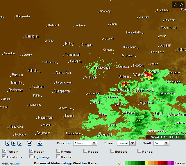
Possible hook echo on the Albury storm, and previously on the storm to the SE of it.
Currently 26.1/19.2 with CAPE 1912 and LI -5.67 on analysis sounding.
Currently 26.1/19.2 with CAPE 1912 and LI -5.67 on analysis sounding.
Nathan Morris
2013 Rainfall
Jan - 3.8mm
Feb - 27.0mm
Mar - 0.0mm
YTD - 30.8mm
2013 Rainfall
Jan - 3.8mm
Feb - 27.0mm
Mar - 0.0mm
YTD - 30.8mm
- dopplerstu
- Cumulus
- Reactions:
- Posts: 29
- Joined: Sun Nov 07, 2010 4:57 pm
- Location: Kings Park, Victoria
Re: Victoria: Trough - showers/rain/storms - 6th-10th Novemb
Will this wind have any effect on the coming systems?
-
stormygirl

- Cumulonimbus
- Reactions:
- Posts: 177
- Joined: Tue Dec 01, 2009 10:06 pm
- Location: Melbourne, SE burbs
- Contact:
Re: Victoria: Trough - showers/rain/storms - 6th-10th Novemb
The sun has just made an appearance on the southern tip of the Mornington Peninsula (Flinders) as I wave goodbye to the cloud band over Phillip Island! Thankfully, I won't be driving home through flood waters. Looking forward to what will unfold this evening for Melbourne.
Online weather station: http://www.stormygirl.net/wx/
-
mick

- Supercell
- Reactions:
- Posts: 1453
- Joined: Mon Nov 30, 2009 6:45 pm
- Location: Mid North SA Baaaaaaaaaaaaaaa
Re: Victoria: Trough - showers/rain/storms - 6th-10th Novemb
Clear skies herre too with the odd wisp blowing through at a great rate of knots. Some weal low lying structure to the west over the bay like yesterday. Things will build quick I reckon, an inch a cell type I hope.
Took the arvo off for the vet, was lucky me for chasing until I hit one of those bloody blind people things on the median strip and went down at 40k. Ankle, elbow, thigh, shoulder and a couple of ribs. A couple of golf balls for good measure. Back wheel came out from under me.
Chase related injury as I was observing as I went down.
-
Rivergirl
- Memorial
- Reactions:
- Posts: 3674
- Joined: Sun Nov 22, 2009 6:04 pm
- Location: Ferny Creek VIC
- Contact:
Re: Victoria: Trough - showers/rain/storms - 6th-10th Novemb
Glad you'll make it back safely stormygirl. I'm packing a bag in case I get caught in the city tonight when I go to see my son.
- weathergasm
- Cumulonimbus
- Reactions:
- Posts: 244
- Joined: Sun Feb 14, 2010 9:32 pm
- Location: Box Hill
Re: Victoria: Trough - showers/rain/storms - 6th-10th Novemb
I am also wary of this wind. I've seen too many otherwise perfect set-ups ruined by strong surface-level winds.
- Rhino
- Supercell
- Reactions:
- Posts: 1227
- Joined: Mon Nov 30, 2009 11:37 am
- Location: Carisbrook-Near Maryborough
Re: Victoria: Trough - showers/rain/storms - 6th-10th Novemb
Trackers going to explode in the next hour, hang on people it's gunna get nasty. Big cells around Warrnambool and Port Fairy. Mallee and Wimmera primed to the hilt.
Rhino.
Rhino.
-
AUS_Twisted
- Storm Chaser
- Reactions:
- Posts: 652
- Joined: Wed Nov 25, 2009 6:15 pm
- Location: Dandenong North, Melb
Re: Victoria: Trough - showers/rain/storms - 6th-10th Novemb
Port Fairy about to get hit pretty good, I reckon in the next hour or so the stuff going on between Mortlake and Geelong should get going a lot better. If I had my car now I'd prob be out near Mortlake and follow things back east
- I_Love_Storms
- Supercell
- Reactions:
- Posts: 2812
- Joined: Wed Dec 02, 2009 2:01 pm
- Location: Hawthorn
Re: Victoria: Trough - showers/rain/storms - 6th-10th Novemb
Or the strong wind may feed into a squall line. It seems one is building out west.
Re: Victoria: Trough - showers/rain/storms - 6th-10th Novemb
The weirdest thing happened, the storm cell came through and the heavy stuff went right around me and the cell has now come and gone with a strong westerly wind, unbelievable.
Mt. Gambier copped it though with 12mm of Rain.
Mt. Gambier copped it though with 12mm of Rain.
- TheFishmanAU
- Cumulonimbus
- Reactions:
- Posts: 111
- Joined: Sun Nov 06, 2011 11:44 am
- Location: Inner Northeastern suburbs of Melbourne
- Contact:
Re: Victoria: Trough - showers/rain/storms - 6th-10th Novemb
The cavalry is about to arrive.
It is exploding in the North West and South West.
It is exploding in the North West and South West.
@The_FishmanAU is all I need to say.
-
crikey
- Supercell
- Reactions:
- Posts: 1314
- Joined: Mon Feb 07, 2011 8:02 pm
- Location: tweed shire NSW and nDUNOLLY.. Nth Central district VIC
- Contact:
Re: Victoria: Trough - showers/rain/storms - 6th-10th Novemb
Just starting to feel a bit more optimistic for that rain to come even though there's not much happening on national loop atm. The jetstream pattern moving towards us is awesome . That nice steep jetstream arch if sustained will move over Vic .

When the sun starts to go down this evening hopeful for something here.
Feels warm and slightly humid here. However any rain that fell this morning has completely evaporated with some strong northerlies.
The synoptic chart is indicating the cold front is already lined up with the trough near the SA/VIC border.
Noticed there is another trough line behind the cold front on the synoptic
http://www.bom.gov.au/australia/charts/ ... _col.shtml" onclick="window.open(this.href);return false;
The national loop not showing up cloud in the west of the state at the moment. I can assure you there is plenty of healthy cloud here. The cloud must be relatively warmer in the west of the state atm . I believe the sat' pic' picks up better the cold tops of clouds.
still reckon Thursday looks good for something, not so convinced this will clear overnight in the west ? The sat pic looks good in the southern ocean moving with a nice clockwise cloud flow.
The wind change and cold front has arrived in the s/west corner of the state.
Dartmoor 10mm in 30 minutes with the wind change to a westerly.A gust of 70km/hr on the change! Dew ponit 17.9degC.The barom at 1003 down south/west and parts of the wimmera. Fabulous!
About 3-4 hrs before the change hits out our way??,as the front is curved back toward the N/west.