mad*moo73 wrote:Well a storm would keep me distracted from the footy which is giving me a nervous breakdown ATM. C'mon Carlton!
Yes, I really hope they get over the line tonight. Been a very tense game already - the last quarter will be hard to watch!
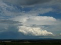
I've got one eye on the footy and one eye on the weather at the moment lol. Really hoping a cell will develop further north than what they are at the moment. The one at Point Liptrap before was a beauty!
Dc449 wrote:lol i know what a plane sounds like! Unless the plane was circilings around for 15 minutes,
Yes Dc449, it did circle round the Melbourne area for about that long, I tracked it on this great website; http://www.flightradar24.com/" onclick="window.open(this.href);return false;
wish I was down Apollo Bay right now. Last time I saw thunder and lightning was at the Bay in Feb! Well here's hoping Monday's systems isn't as weak as this one. The high pressure ridge is pushing and weaking they cold fronts to the south.
I heard the same Geoff, jumped straight on that website to check. Unusual to have flights climbing to cruise over the eastern suburbs and making so much noise too...
Well had a few spots of rain at about 7:50pm, but dead calm, and almost balmy at 21.3c. Winds are really pickup in the last 15 minutes, just copped a gust of 48kmh here, made the house creak. RH is diving from around 85% to 55% and temp from 20.1c to 16.4c. I guess that's the lot tonight
Dc449 wrote:lol i know what a plane sounds like! Unless the plane was circilings around for 15 minutes,
Yes Dc449, it did circle round the Melbourne area for about that long, I tracked it on this great website; http://www.flightradar24.com/" onclick="window.open(this.href);return false;
In that case i take back everything i said, i obviously have no clue how to tell the difference between thunder and a plane!, in my defence it has been a while since ive heard thunder
Cape Liptrap about to be hit by another thunderstorm. Lucky for them tonight. Would suspect some strong winds associated with that thunderstorm.
I manged to see very distant lightning, just flashes really to my south and southeast over the ocean earlier from that thunderstorm when it was off the west coast.
Jake - Senior AWF Forecaster
Feel free to send me a private message if you have any questions.
If I knew that last cell would fire up like that I could have easily made it down to the Cape Liptrap area in time, hopefully Monday night gives us something better on or closer to land.
Looking like there is an outside chance of reaching 30c in Melbourne tomorrow, looks like there will be very warm air over the state from first thing tomorrow, with 850 temps in the mid teens. If we see plenty of sun (and sun is the big factor) we could see the first 30c of the season, if that happened it would have to be one of the earliest on record. I know Melb made 29.9 on the 12th of September a few years back.
Given Sydney made 30c by 11am this morning with a similar airmass would have to give it a chnace.
Another thing that looks more likely tomorrow are very strong winds, the pressure gradient looks real tight ahead of the approaching front, wouldn't be surprised if there was a severe weather warning issued.
Severe Weather Warning
for damaging winds
for people in the South West, North Central, Wimmera, Central, West and South Gippsland, East Gippsland and North East forecast districts.
A strong cold front will cross the Bight to reach western Victoria Monday afternoon, central Victoria Monday evening then extend to the far east by early Tuesday morning.
Locally damaging winds increasing from the west on Monday. Winds have the potential to averaging 50-65 km/h with peak gusts around 90 km/h over parts of the South West, North Central, Wimmera, Central, West and South Gippsland, East Gippsland and North East forecast districts, mainly with the passage of the cold front. Regions above about 500m elevation may experience average winds up to 80km/h with gusts to 110 km/h.
Looks like to me we may be in for a decent squall line as well, come the late afternoon or evening. Timing is almost perfect by the sounds of it..
Sunny morning. Isolated showers developing in the late afternoon, increasing to areas of rain at night. The chance of a thunderstorm in the afternoon and evening. Winds northerly averaging up to 55 km/h tending westerly up to 35 km/h by early evening before easing at night to around 25 km/h.
Pencil in a line of storms tomorrow night, wind shear and heating should be more than adequate. I'm looking for a storm to hit CBD at around 7.30pm then ripping through the eastern suburbs with damaging winds.
Too dry just like it was Yesterday, anything that trys to develop whether its rain or storms will get shredded by the wind for Melbourne. I'll be suprised if I get 1mm from the front later Tomorrow. The forecast looks abit rich to me.
Now that the fronts are finally getting more aggressive (finally the Negative SAM is having some effect) The Country is bone dry (thanks to the Postive IOD any N/NW winds are very dry) same thing happened in 07, 08 Negative SAM/Positive IOD.
Supercellimpact wrote:The cold front is looking impressive on satalitte, nice air field behind.
Yes indeed, nice cold air mass surging north from Antarctica, and a lot of hot air building across the Outback! The combination of these two differing air masses should create some seriously wild weather tomorrow! Hopefully a round of severe thunderstorms will be thrown in as the cold front marches through