The western side of the bay is usually warmer than other suburbs, except in an easterly stream. In a NW'ly stream, Avalon (and Werribee) can be 2C warmer than Melbourne.Nick Sykes » Sat Sep 17, 2011 12:27 pm wrote:Nick Sykes wrote: ... I have noticed that Melbourne often struggles to get going temp wise on northerly wind days, often reading lower than other sites while at the same time Avalon always seems very warm.

Welcome New Members! We want to hear from you. Register, stop lurking and start posting!
Vic: Unstable Warm Weather Sept 16th- 19th
-
3030WX

- Cumulus
- Reactions:
- Posts: 68
- Joined: Sun Feb 06, 2011 11:21 pm
- Location: Truganina, Victoria
- Contact:
Re: Vic: Unstable Warm Weather Sept 16th- 19th
Current weather at Truganina
Don't knock the weather. If it didn't change once in a while, nine out of ten people couldn't start a conversation. - Kin Hubbard
Don't knock the weather. If it didn't change once in a while, nine out of ten people couldn't start a conversation. - Kin Hubbard
- I_Love_Storms
- Supercell
- Reactions:
- Posts: 2812
- Joined: Wed Dec 02, 2009 2:01 pm
- Location: Hawthorn
Re: Vic: Unstable Warm Weather Sept 16th- 19th
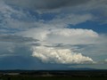
Sky looking unstable out past springvale to sw. Mammatus and maybe some small cells trying to fire with what looks like a semi rain curtain (rain maybe not reaching the ground at this point)
-
crikey

- Supercell
- Reactions:
- Posts: 1314
- Joined: Mon Feb 07, 2011 8:02 pm
- Location: tweed shire NSW and nDUNOLLY.. Nth Central district VIC
- Contact:
Re: Vic: Unstable Warm Weather Sept 16th- 19th
A S/West wind change is still well west around Ceduna at 12.30pm pm obs ..only just.
I like the clockwise pattern airstream over SA atm as seen on stormtracker and barom pressure has dropped in some parts . Coonawaara has dropped 3 hPascals in 3 hrs and some areas of SA.and S/west VIC
Nice little bend in that low pressure belt over SA.
The winds have increased along that Nwest line atm which would be characteristic of a coming change.
The trough area seems quite broad and slow moving?
Gee these NWesterlies are dry as a dead dingo' carcas. LOL
Mildura 4% rel Humidity atm. LOL
Can't believe all those models and soundings etc that have been presented can get it so wrong. and for that reason alone. Going to hold some belief. LOL
Only hope of moisture is from tonight on cooling and some S/west inflow on the change
Going to look for strong gradients in temp an RH on the change.
Those models saw something ,so keen to find out what it is. LOL
I am going to hold out for something? on a west/swest change which is a long way off atm.
-
crikey
- Supercell
- Reactions:
- Posts: 1314
- Joined: Mon Feb 07, 2011 8:02 pm
- Location: tweed shire NSW and nDUNOLLY.. Nth Central district VIC
- Contact:
Re: Vic: Unstable Warm Weather Sept 16th- 19th
Portland currently 100% RH and pressure has dropped to 1005 hpascalsI_Love_Storms » Sat Sep 17, 2011 2:39 pm wrote:I_Love_Storms wrote:Sky looking unstable out past springvale to sw. Mammatus and maybe some small cells trying to fire with what looks like a semi rain curtain (rain maybe not reaching the ground at this point)
Warnambool 1004.hPascals
You would think any High RH areas bordering with very low RH boundaries could be interesting
- I_Love_Storms
- Supercell
- Reactions:
- Posts: 2812
- Joined: Wed Dec 02, 2009 2:01 pm
- Location: Hawthorn
Re: Vic: Unstable Warm Weather Sept 16th- 19th
Mustn't much. Nothing on radar. Upper levels probably still quite cold though so this should help any instability
-
stratospear

- Supercell
- Reactions:
- Posts: 1261
- Joined: Sat Dec 19, 2009 9:38 am
- Location: Usually Bendigo
Re: Vic: Unstable Warm Weather Sept 16th- 19th
25% RH here, but 50%RH just down the road at Redesdale. Looks like some convection in the mid-layers to our NW, but no sign of anything at nearer the surface.
- I_Love_Storms
- Supercell
- Reactions:
- Posts: 2812
- Joined: Wed Dec 02, 2009 2:01 pm
- Location: Hawthorn
Re: Vic: Unstable Warm Weather Sept 16th- 19th
There's an absolute heap of mammatus over waverley at the moment
-
apocalypse

- Cumulonumbus Calvas
- Reactions:
- Posts: 761
- Joined: Tue Jan 19, 2010 6:17 pm
- Location: Wagga Wagga, NSW 189m asl
Re: Vic: Unstable Warm Weather Sept 16th- 19th
DP went down for a bit, but now on the way up again, currently 22.7/11.3. Had some mammatus and virga go overhead not too long ago.
Nathan Morris
2013 Rainfall
Jan - 3.8mm
Feb - 27.0mm
Mar - 0.0mm
YTD - 30.8mm
2013 Rainfall
Jan - 3.8mm
Feb - 27.0mm
Mar - 0.0mm
YTD - 30.8mm
- Harley34
- Cumulonumbus Calvas
- Reactions:
- Posts: 580
- Joined: Sat Mar 06, 2010 1:08 pm
- Location: Ringwood East, Melbourne
Re: Vic: Unstable Warm Weather Sept 16th- 19th
At what time are the first thunderstorm cells due near Melbourne?
Re: Vic: Unstable Warm Weather Sept 16th- 19th
i dont see anything happening today...too dry
- dopplerstu
- Cumulus
- Reactions:
- Posts: 29
- Joined: Sun Nov 07, 2010 4:57 pm
- Location: Kings Park, Victoria
Re: Vic: Unstable Warm Weather Sept 16th- 19th
Don't think they willHarley34 » Sat Sep 17, 2011 4:32 pm wrote:Harley34 wrote:At what time are the first thunderstorm cells due near Melbourne?
- Harley34
- Cumulonumbus Calvas
- Reactions:
- Posts: 580
- Joined: Sat Mar 06, 2010 1:08 pm
- Location: Ringwood East, Melbourne
Re: Vic: Unstable Warm Weather Sept 16th- 19th
Yep i agree, but i won't count anything out yet.
Monday looking much better..
Monday looking much better..
-
crikey
- Supercell
- Reactions:
- Posts: 1314
- Joined: Mon Feb 07, 2011 8:02 pm
- Location: tweed shire NSW and nDUNOLLY.. Nth Central district VIC
- Contact:
Re: Vic: Unstable Warm Weather Sept 16th- 19th
30 % relative humidity at ground level and just had a little virga fall to the ground . In fact you can see the little trails of virga falling from some cloud and drying out well before ground level
very warm and dry here and little wind atm. Some cloud starting to darken and flatten out.
definitely no cumulus here though in in the Maryborough area 3.30pm
very warm and dry here and little wind atm. Some cloud starting to darken and flatten out.
definitely no cumulus here though in in the Maryborough area 3.30pm
- droughtbreaker
- Supercell
- Reactions:
- Posts: 2844
- Joined: Wed Nov 25, 2009 7:50 pm
- Location: Mount Macedon, VIC, 520m asl
Re: Vic: Unstable Warm Weather Sept 16th- 19th
Humidity is not too bad here, around 50% RH with 18C. It just looks like a very weak system for whatever reason. There is a lot of virga falling from middle level cloud, absolutely no convectional cloud though.
- aussiestormfreak
- Cumulonumbus Calvas
- Reactions:
- Posts: 534
- Joined: Thu Feb 03, 2011 9:52 am
- Location: Melbourne, Corryong, Merimbula, and Fiji
- Contact:
Re: Vic: Unstable Warm Weather Sept 16th- 19th
Unless a thunderstorm develops after dark, I think this cold front is more or less a write-off, and I'll have to wait until Monday at the earliest. 
-
AUS_Twisted

- Storm Chaser
- Reactions:
- Posts: 652
- Joined: Wed Nov 25, 2009 6:15 pm
- Location: Dandenong North, Melb
Re: Vic: Unstable Warm Weather Sept 16th- 19th
I wouldn't call it a right off yet, things are just getting going far SW. Seems like the front is a bit delayed.
Edit: Looking pretty weak far SW, will see what happens in the next 3 hours
Edit: Looking pretty weak far SW, will see what happens in the next 3 hours
-
flatcam
- Cumulonimbus
- Reactions:
- Posts: 182
- Joined: Wed Jan 05, 2011 8:16 pm
- Location: Craigieburn, Victoria
Re: Vic: Unstable Warm Weather Sept 16th- 19th
Some development starting to occur on the radar now. Hopefully it continues and something eventuates from it. The storm potential chart has some activity predicted for a bit later which is good.
The air was amazing before the sun went down. Really felt like Summer again!
Cheers, Cam
Edit: looking great around Cape Liptrap! Anyone see any sparks from it?
The air was amazing before the sun went down. Really felt like Summer again!
Cheers, Cam
Edit: looking great around Cape Liptrap! Anyone see any sparks from it?
Re: Vic: Unstable Warm Weather Sept 16th- 19th
Extremely unsettled dark sky here, matamus clods everywhere !
Go the bombersss!
-
AUS_Twisted
- Storm Chaser
- Reactions:
- Posts: 652
- Joined: Wed Nov 25, 2009 6:15 pm
- Location: Dandenong North, Melb
Re: Vic: Unstable Warm Weather Sept 16th- 19th
CG on the cell to the SE, might be making a decision soon.
- aussiestormfreak
- Cumulonumbus Calvas
- Reactions:
- Posts: 534
- Joined: Thu Feb 03, 2011 9:52 am
- Location: Melbourne, Corryong, Merimbula, and Fiji
- Contact:
Re: Vic: Unstable Warm Weather Sept 16th- 19th
No fair! That cell that AUS_Twisted mentioned is offshore near Wonthaggi, heading towards Wilsons Promontory
Hope it's a sign that more such thunderstorm activity may organise around Melbourne as the wind change pushes through...
Hope it's a sign that more such thunderstorm activity may organise around Melbourne as the wind change pushes through...