Welcome New Members! We want to hear from you. Register, stop lurking and start posting!
Vic - heralding in March with humidity and an Easterly dip!!

Re: Vic - heralding in March with humidity and an Easterly d
Interesting day tomorrow. Should see a storm or two get going, especially in the north. Can't imagine they'd be terribly severe, but you never know.
-
flatcam
- Cumulonimbus
- Reactions:
- Posts: 182
- Joined: Wed Jan 05, 2011 8:16 pm
- Location: Craigieburn, Victoria
Re: Vic - heralding in March with humidity and an Easterly d
Some very light drizzle here at the moment. I would like a storm here tonight, but I can't really see it happening 
Hoping for some good ones tomorrow.
Cheers, Cam
EDIT: Trust the small rain band to weaken over us here, and then intensify on the other side!
Hoping for some good ones tomorrow.
Cheers, Cam
EDIT: Trust the small rain band to weaken over us here, and then intensify on the other side!
-
Didjman

- Supercell
- Reactions:
- Posts: 2104
- Joined: Fri Sep 03, 2010 2:52 pm
- Location: Wallan, Vic 328m ASL
- Contact:
Re: Vic - heralding in March with humidity and an Easterly d
I am thinking of heading down to Avalon tomorrow arvo for some plane spotting(Airshow exhibits fliying in), so will be out and about for wx also:D
Peter
Peter
-
Supercellimpact

- Supercell
- Reactions:
- Posts: 1241
- Joined: Thu Oct 07, 2010 8:39 pm
- Location: Bendigo
Re: Vic - heralding in March with humidity and an Easterly d
Tommorrow looks to be ok storm wise with great shear so you would expect storms to be fast moving by pulsey, but doesn't matter a storms a storm. Also exxpecting 5-10mm overnight to midday tommorrow.
- SC.
- Cumulonimbus
- Reactions:
- Posts: 346
- Joined: Wed Nov 25, 2009 5:57 pm
- Location: Wheelers Hill
- Contact:
Re: Vic - heralding in March with humidity and an Easterly d
I just saw a lot of birds flying towards Scoresby and Knoxfield, good indication of a little rain and a few insects to feed on.
-
daviescr

- Supercell
- Reactions:
- Posts: 1394
- Joined: Wed Dec 02, 2009 5:40 pm
- Location: Warranwood, Vic
Re: Vic - heralding in March with humidity and an Easterly d
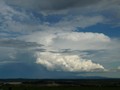
The water was fantastic today, took the family down to the beach for the afternoon, had a good 4 hours before the cloud started to drop it's load. Saw some lovely mammatus at about 3.30-4pm.
Also made a complete idiot of myself when I saw a guy on the beach with his family - I could have sworn it was Anthony Violi (from a pic I saw on stalkbook. It wasn't.
Also made a complete idiot of myself when I saw a guy on the beach with his family - I could have sworn it was Anthony Violi (from a pic I saw on stalkbook. It wasn't.
-
Petros

- Supercell
- Reactions:
- Posts: 2005
- Joined: Tue Dec 01, 2009 6:25 pm
- Location: Maffra, Gippsland, Vic
Re: Vic - heralding in March with humidity and an Easterly d
Went through the models before, couldnt come up with much to get excited about.
Mod's - whats the date range of this thread?
Mod's - whats the date range of this thread?
-
daviescr
- Supercell
- Reactions:
- Posts: 1394
- Joined: Wed Dec 02, 2009 5:40 pm
- Location: Warranwood, Vic
Re: Vic - heralding in March with humidity and an Easterly d
You tell me Petros  Didn't you start this thread anyway???
Re: Vic - heralding in March with humidity and an Easterly d
Almost 10mm here well picked by the EC and UK models, not bad for a stable fine weekend which alot of us thought it would be earlier in the week
-
daviescr
- Supercell
- Reactions:
- Posts: 1394
- Joined: Wed Dec 02, 2009 5:40 pm
- Location: Warranwood, Vic
Re: Vic - heralding in March with humidity and an Easterly d
Agree John, some pretty respectable totals around this morning for a system that I had a hard time believing would happen. Made it to 7.5mm here to 9am, 3.5mm in the last 45 minutes.
-
Supercellimpact
- Supercell
- Reactions:
- Posts: 1241
- Joined: Thu Oct 07, 2010 8:39 pm
- Location: Bendigo
Re: Vic - heralding in March with humidity and an Easterly d
Up to 8mm's here which is pretty much what EC predicted and I said last night.
- MurrayRiver1712
- Cumulus
- Reactions:
- Posts: 61
- Joined: Sat Feb 05, 2011 10:18 am
- Location: Echuca
Re: Vic - heralding in March with humidity and an Easterly d
Have had rain off and on all night here in Echuca. Very heavy atm, still quite warm.
-
Petros
- Supercell
- Reactions:
- Posts: 2005
- Joined: Tue Dec 01, 2009 6:25 pm
- Location: Maffra, Gippsland, Vic
Re: Vic - heralding in March with humidity and an Easterly d
Light rain started a little after midnight and persisted more on than off for the rest of the night! 8mm 
FAR more than forecast for Gippy.
The rain has increased over last 20 mins to be "steady light rain" and the radar gives me hope of another hour of this. Dead calm, almost warm and the baro stuck on 1009 hPa.
Could we add the dates 27/2/11 to 2/3/11 to the thread title Dav?
FAR more than forecast for Gippy.
The rain has increased over last 20 mins to be "steady light rain" and the radar gives me hope of another hour of this. Dead calm, almost warm and the baro stuck on 1009 hPa.
Could we add the dates 27/2/11 to 2/3/11 to the thread title Dav?
-
flatcam
- Cumulonimbus
- Reactions:
- Posts: 182
- Joined: Wed Jan 05, 2011 8:16 pm
- Location: Craigieburn, Victoria
Re: Vic - heralding in March with humidity and an Easterly d
Pretty much rained all night here.
Does anyone think a thunderstorm could develop on or pass through Craigieburn today? The forecast says central and eastern regions, and I'm not exactly sure what we would be classified here?
I Have to decide whether to go for a drive this afternoon or not.
Cheers, Cam
EDIT: The storm potential chart appears to show the cells developing in the far north. It looks like they won't even come close to us here
Last edited by flatcam on Sun Feb 27, 2011 10:45 am, edited 1 time in total.
- MurrayRiver1712
- Cumulus
- Reactions:
- Posts: 61
- Joined: Sat Feb 05, 2011 10:18 am
- Location: Echuca
Re: Vic - heralding in March with humidity and an Easterly d
Rain has stopped here in Echuca and its clearing up with patches of blue, and the sun trying to shine through. Could make things a bit sticky.
- droughtbreaker
- Supercell
- Reactions:
- Posts: 2844
- Joined: Wed Nov 25, 2009 7:50 pm
- Location: Mount Macedon, VIC, 520m asl
Re: Vic - heralding in March with humidity and an Easterly d
Just over 5mm here, very drizzly and foggy, in other words miserable.
-
Petros
- Supercell
- Reactions:
- Posts: 2005
- Joined: Tue Dec 01, 2009 6:25 pm
- Location: Maffra, Gippsland, Vic
Re: Vic - heralding in March with humidity and an Easterly d
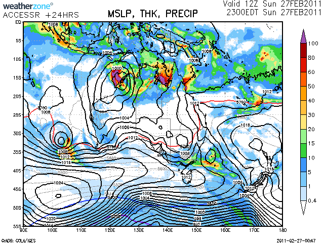
Light drizzly stuff now (has been for past 30mins after light rain stopped). The gauge now hold 13mm! Baro has nudged up slowly to 1010 hPa, its 20C, calm, lost an arvo of golf but will gladly sacrifice it for 13mm of nice light summer rain.
I see the consensus of models jumped onto this rain here in Gippy fairly late (basically last night) after providing guidance for 2-5mm for many days.
AccessR's +24 hour chart certainly looks like a classic dip scenario..... pity it will clear out fairly quickly.
I see the consensus of models jumped onto this rain here in Gippy fairly late (basically last night) after providing guidance for 2-5mm for many days.
AccessR's +24 hour chart certainly looks like a classic dip scenario..... pity it will clear out fairly quickly.
Last edited by Petros on Sun Feb 27, 2011 1:06 pm, edited 3 times in total.
-
crikey

- Supercell
- Reactions:
- Posts: 1314
- Joined: Mon Feb 07, 2011 8:02 pm
- Location: tweed shire NSW and nDUNOLLY.. Nth Central district VIC
- Contact:
Re: Vic - heralding in March with humidity and an Easterly d
Had 10mm on the flat pastoral plains of dunolly some 27 km west of maryborough. Overnight . Very tropical and humid last night 24deg at 11.00pm
still warm and humid here. It is 12.00pm partly cloudy, very 'muggy' and 27 degrees. They should make Dunolly in the wimmera forecast district because it is more like what we usually get. . Kilmore and castlemaine usually are 3 to 5 degrees lower than us some days. They are closer to hills. We have already reached the forescast top for wimmera.
I noticed the SE breeze was warm this morning so l figured any showers or rain down south didn't really cool things down?
Anyway as a gardner l am wrapped the avocado seed l planted has transformed this summer into a healthy 3 foot bush, l might actually get a few cantelopes to grow a decent size, the paddocks are green, zucchini marrows just keep growing, neighbour has been delivering cucumbers, peaches and plums for weeks. We have not seen this for 10 years l have been out here,out in the normally dusty dry plains of dunolly, even some fatter tomatoes
-
crikey
- Supercell
- Reactions:
- Posts: 1314
- Joined: Mon Feb 07, 2011 8:02 pm
- Location: tweed shire NSW and nDUNOLLY.. Nth Central district VIC
- Contact:
Re: Vic - heralding in March with humidity and an Easterly d
I Noticed that the remnants of cyclone carlos has finally starting to be integrated into the peripheral polar jetstream air. As it is entering the jetstream cloud mass is increasing and developing .
http://www.metoffice.gov.uk/satpics/australasia_IR.html" onclick="window.open(this.href);return false;
Travelling with the normal west to east flow. Looks like it could bring some cloud cover to vic if it travails north enough on the jetstrem .As did the remnants of cyclone dianne which gave us some cloud cover even during a high.Although l believe it could be a declining high has it seems as a crest is developing in the jetstream and that would indicate to me a deteriorating high.?
A crest is developing in the jetstream air which could keep it a little north along the australian coastline.
The crest also has a cloudy cold upper air front 'as it were'. The collision of the ex-carlos low with the jetstream is producing very heavy rain out to sea. Looks like lots of action in the integration.
The main jetstream tends to take ex-cylone lows' out' as it were but still leaves an adundance of cloud cover that trails from west to east as the jetstream passes. I really look forward to this watch and implications. Love to hear your thoughts
Thanks petros for your map of precipitation it will help with my study. May l have the link to this map thanks.
see satallite animation. Not sure how long it would take that cloud mass to reach SA , VIC and TAS? Guessing about 30 hours? NO. slow moving high could take days?
Last edited by crikey on Sun Feb 27, 2011 6:32 pm, edited 1 time in total.
-
flatcam
- Cumulonimbus
- Reactions:
- Posts: 182
- Joined: Wed Jan 05, 2011 8:16 pm
- Location: Craigieburn, Victoria
Re: Vic - heralding in March with humidity and an Easterly d
Well, the cloud didn't burn off here at all. Unless things improve dramatically, I don't think there's going to be any storms today.
The storm potential chart today had the cells developing between one and four today.
Cheers, Cam
The storm potential chart today had the cells developing between one and four today.
Cheers, Cam