
Welcome New Members! We want to hear from you. Register, stop lurking and start posting!
Victoria - Tropical rain event - February 2nd-8th 2011
-
Supercellimpact

- Supercell
- Reactions:
- Posts: 1238
- Joined: Thu Oct 07, 2010 8:39 pm
- Location: Bendigo
Re: Victoria - Tropical rain event - February 2nd-8th 2010
So tommorrows storm instability will come from that cloud mass in Central and southern NSW ?
-
Petros

- Supercell
- Reactions:
- Posts: 2001
- Joined: Tue Dec 01, 2009 6:25 pm
- Location: Maffra, Gippsland, Vic
Re: Victoria - Tropical rain event - February 2nd-8th 2010
Johnoo, I just totally discount AccessG from experience over past 2 months, too lazy to access EC direct (simply look at WZ EC "rainless" charts and as you know (and poo hoo) - I have heaps of faith in GFS as it comes to play for us SE of the Vic divide.
WISH it would rain though - and also when I posted, AccessR hadnt updated on WZ and have been glued to Yasi since. So I guess a bit half baked and hopefully overly pessamistic. Hope you get plenty - and you will all know about it if we get some out here of course!!!
WISH it would rain though - and also when I posted, AccessR hadnt updated on WZ and have been glued to Yasi since. So I guess a bit half baked and hopefully overly pessamistic. Hope you get plenty - and you will all know about it if we get some out here of course!!!
- Jake Smethurst
- Supercell
- Reactions:
- Posts: 3583
- Joined: Mon Nov 23, 2009 8:49 pm
- Location: Cheltenham
Re: Victoria - Tropical rain event - February 2nd-8th 2010
Isolated shower and thunderstorm acitivty tomorrow is thanks to the increase in moisture levels across the state overnight, and the trough that moved over most of the state today. This trough will retrograde to western/southern Victoria tomorrow and remain there most of the week, thus acting as the trigger. I think most areas of Victoria should see some action during the week. This will accumulate into a larger event on Saturday with rain areas.
Jake - Senior AWF Forecaster
Feel free to send me a private message if you have any questions.
Feel free to send me a private message if you have any questions.
- cutofflow
- Cumulus
- Reactions:
- Posts: 95
- Joined: Sun Aug 29, 2010 8:29 pm
- Location: Near Maryborough - North central vic
Re: Victoria - Tropical rain event - February 2nd-8th 2010
EC totally ignoring most models lead, hell bent on this cold air interaction friday evening. Been watching each run and its just been going from strength to strength. Very difficult to pick a decaying cyclone AND the low pressure polar air belt and get them to interact. We are only 72-96hrs away 
GFS just wants the current trough to sit no further than north of the Murray and use the cyclone exhaust / tropical infeed all to itself. It had been working the trough southwest 100/200kms at a time in the last 3 runs but the 06z run has gone back the other way.
CMC wants a foot in each door. ACCESS rubbish
- WaterBaby
- Cumulonimbus
- Reactions:
- Posts: 109
- Joined: Sun Jan 30, 2011 5:24 pm
- Location: Loddon shire, VIC
Re: Victoria - Tropical rain event - February 2nd-8th 2010
I hope I'm posting this in the right spot (sorry in advance).
I've been keeping a very close eye on any up coming rains and came upon this chart:
http://wxmaps.org/pix/prec7.html" onclick="window.open(this.href);return false;
Being a total newbie and not wanting to interpret it wrong... can someone explain the bottom diagram to me? Does it mean that most of western Vis has a greater than 600% chance of typical rain fall for this period? I'm probably totally way off....
We're going away for the weekend and i'll be lifting things up and taking certificates with me in case we are isolated again. If Cairn Curran gets much rain, we are screwed.
- Twister
- Cumulonumbus Calvas
- Reactions:
- Posts: 914
- Joined: Sun Nov 29, 2009 10:47 pm
- Location: Brisbane Qld
Re: Victoria - Tropical rain event - February 2nd-8th 2010
Yeah it all depends on how far W and S Yasi gets
TC Ants looks to bring some nice rain and Storms along the Murray which is bad news for many up that way, and yes many areas around and W and S of Swan hill still quite a bit under water even after 40c days
Looking forward to seeing how far South Tc Ants can get and what it will bring us, though think tomorrow like many my eyes will be in N Qld
Hopefully models will settle by tomorrow night Thursday morning
Looking like some solid falls in N NE parts and maybe central areas as well
Now Living in Wet QLD
- HarleyB
- Cumulonumbus Calvas
- Reactions:
- Posts: 839
- Joined: Sun Oct 10, 2010 9:39 pm
- Location: Wangaratta
Re: Victoria - Tropical rain event - February 2nd-8th 2010
That had better not include this district, because thats where most of the flooding up north originates, a little west of here actuallyAnthony Violi wrote: As opposed to most to of Northern and Eastern Vic, 200mm is my tip for most places.

Re: Victoria - Tropical rain event - February 2nd-8th 2010
From Weatherzone...
On Wednesday, a broad trough across the interior and a series of lows is likely to allow widespread storm development.
Storms are likely to be severe across the southeast with flash flooding, large hail and damaging winds possible.
So fingers crossed for a nice storm or two.
On Wednesday, a broad trough across the interior and a series of lows is likely to allow widespread storm development.
Storms are likely to be severe across the southeast with flash flooding, large hail and damaging winds possible.
So fingers crossed for a nice storm or two.
Re: Victoria - Tropical rain event - February 2nd-8th 2010
Please can we get a nice summer storm tomorrow!! cmon weather gods be kind for once this year.
fortius quo fidelius

Re: Victoria - Tropical rain event - February 2nd-8th 2010
Yeah I'm with you DC.
Don't have to go back to work till Monday so i'm really hoping for a bit of storm action.
It is always seems to happen when I'm at work.
Don't have to go back to work till Monday so i'm really hoping for a bit of storm action.
It is always seems to happen when I'm at work.
-
Karl Lijnders

- Tornadic Supercell
- Reactions:
- Posts: 5771
- Joined: Sun Nov 22, 2009 11:17 pm
- Location: Knoxfield, Victoria
Re: Victoria - Tropical rain event - February 2nd-8th 2010
While some debate how dry and brown we are we are heading towards another pretty savage rain event for the north and east which could spark further problems.
EC has around 100mm widespread through many areas and other models including CMC, NOGAPS have about the same with GFS still persisting on it's own pushing rain northeast.
In any case it is gonig to be a very large rain producer for the northeast and catchments and possibly into the fire areas of Gippsland. Nothing like nature putting out what it started!
Melbourne at this time looks good to recieve average Feb rainfalls and to remain cool next week. Not a bad start to the month and keeps running in the theme of wetter and cooler than normal.
Former Owner - The Australian Weather Forum. Email me anytime - weatherman1000@hotmail.com
Re: Victoria - Tropical rain event - February 2nd-8th 2010
Hoping for a thunderstorm today, however judging by the latest run on Stormcast, all interest for areas near Melbourne is Friday afternoon. Very high numbers associated with this run, so i'm excited. Been a while since I've posted anything, but then again things have been rather boring, apart from the Cat 5 cyclone Yasi about to smash Cairns and surrounding areas.
- Proteous
- Cumulonimbus
- Reactions:
- Posts: 200
- Joined: Fri Nov 27, 2009 4:57 pm
- Location: Paynesville Gippsland Lakes.
Re: Victoria - Tropical rain event - February 2nd-8th 2010
Visability down to about 1 Km because of smoke so can't see the sky. Thought we might be a bit of chance for a rumble later so will have to watch radar closely. EC has 3 inches of rain here for Saturday, hmmmm.
Re: Victoria - Tropical rain event - February 2nd-8th 2010
First spots of rain at 0900hrs is quiet heavy at present. Hard to beleive but Hunters Hill is already up to 41mm really hasn't looked much on radar must have been really heavy up there.
-
Karl Lijnders
- Tornadic Supercell
- Reactions:
- Posts: 5771
- Joined: Sun Nov 22, 2009 11:17 pm
- Location: Knoxfield, Victoria
Re: Victoria - Tropical rain event - February 2nd-8th 2010
High humidity and near saturation at all levels will mean that rainfall will fall very easily!! Slack steering also means that heavy cores will pump the same area for a greater period of time.
Nice day here in Melbourne so far with lots of high cloud and light NE winds. Can make out convection over the N and NE sky.
Cannot see much in the way of storms today IMO, but should see rain develop overnight with the chance of thunder.
Nice day here in Melbourne so far with lots of high cloud and light NE winds. Can make out convection over the N and NE sky.
Cannot see much in the way of storms today IMO, but should see rain develop overnight with the chance of thunder.
Former Owner - The Australian Weather Forum. Email me anytime - weatherman1000@hotmail.com
-
stratospear

- Supercell
- Reactions:
- Posts: 1261
- Joined: Sat Dec 19, 2009 9:38 am
- Location: Usually Bendigo
Re: Victoria - Tropical rain event - February 2nd-8th 2010
Latest GFS had me falling out of my chair... 500mm bullseye over Benalla in coming week, mostly falling in coming days. End of run has 100mm+ along northern slopes from leftovers of Yasi.
-
Karl Lijnders
- Tornadic Supercell
- Reactions:
- Posts: 5771
- Joined: Sun Nov 22, 2009 11:17 pm
- Location: Knoxfield, Victoria
Re: Victoria - Tropical rain event - February 2nd-8th 2010
I think GFS is having a meltdown and has been struggling getting charts out in it's single run. So I am disregarding what it has to say.
In any case the ensemble looks wet for the region.
I am finding that the consensus is behind EC and the rainfall is more logical.
In any case the ensemble looks wet for the region.
I am finding that the consensus is behind EC and the rainfall is more logical.
Former Owner - The Australian Weather Forum. Email me anytime - weatherman1000@hotmail.com
-
Karl Lijnders
- Tornadic Supercell
- Reactions:
- Posts: 5771
- Joined: Sun Nov 22, 2009 11:17 pm
- Location: Knoxfield, Victoria
Re: Victoria - Tropical rain event - February 2nd-8th 2010
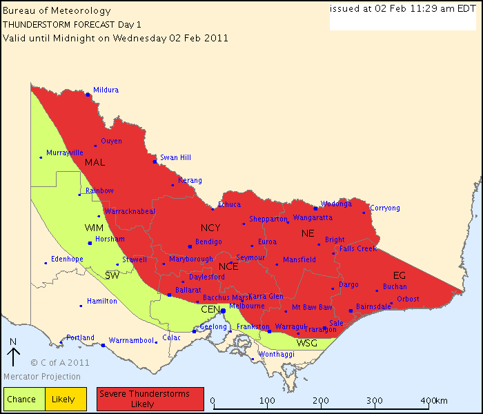
IDV65758
Australian Government Bureau of Meteorology
Victoria Regional Office
THUNDERSTORM FORECAST
Issued at 11:29 am Wednesday, 2 February 2011,
Valid until midnight on Wednesday, 2 February 2011.
A broad threat area of severe thunderstroms across northern and eastern Victoria for Today. The combination of surface trough, tropical moisture levels from ex-Tropical Cyclone Anthony and a warm airmass will provide ideal conditions for thunderstorms to develop. Thunderstorms under these conditions are likely to produce heavy rainfall leading to localised flash flooding. There is also the risk of hail and wind gusts with storms due to high levels of instability.
Former Owner - The Australian Weather Forum. Email me anytime - weatherman1000@hotmail.com
Re: Victoria - Tropical rain event - February 2nd-8th 2010
what time are the storms supposed to kick off?
if its coming down from the north, are they likely to encroach toward melbourne...we are on the edge at least on that chart!
if its coming down from the north, are they likely to encroach toward melbourne...we are on the edge at least on that chart!
- HarleyB
- Cumulonumbus Calvas
- Reactions:
- Posts: 839
- Joined: Sun Oct 10, 2010 9:39 pm
- Location: Wangaratta
Re: Victoria - Tropical rain event - February 2nd-8th 2010
No way will we see storms here IMO, will be wrong now that i've said that 