Welcome New Members! We want to hear from you. Register, stop lurking and start posting!
Victoria: Rain/Storm event: 29th Nov - 5th Dec (Obs)
Re: Victoria: Rain/Storm event: 29th Nov - 5th Dec (Obs)
Yeah couldn't agree more. Love those shots Shane.
Re: Victoria: Rain/Storm event: 29th Nov - 5th Dec (Obs)
It seems this is the system that keeps on giving. I've removed my pictures, but will put 'em back when she dies down again.
Last edited by schitzengiggles on Sun Dec 05, 2010 11:49 am, edited 4 times in total.
- Jake Smethurst
- Supercell
- Reactions:
- Posts: 3583
- Joined: Mon Nov 23, 2009 8:49 pm
- Location: Cheltenham
Re: Victoria: Rain/Storm event: 29th Nov - 5th Dec (Obs)
Love it Ryan!!! 
T/DP = 28/18.
T/DP = 28/18.
Jake - Senior AWF Forecaster
Feel free to send me a private message if you have any questions.
Feel free to send me a private message if you have any questions.
- Hamlan
- Storm Chaser
- Reactions:
- Posts: 449
- Joined: Tue Dec 22, 2009 11:05 pm
- Location: Northern suburbs
Re: Victoria: Rain/Storm event: 29th Nov - 5th Dec (Obs)
Great shot Ryan! now I know where you were  I was not far away. At the same time there was a rotating cell (to its north and heading east) with nice low level structure with wall cloud and funnel. What a show we got!
Last edited by Hamlan on Sun Dec 05, 2010 11:31 am, edited 1 time in total.
- droughtbreaker
- Supercell
- Reactions:
- Posts: 2844
- Joined: Wed Nov 25, 2009 7:50 pm
- Location: Mount Macedon, VIC, 520m asl
Re: Victoria: Rain/Storm event: 29th Nov - 5th Dec (Obs)
Convection has started to the WNW, nice and early. Just how much it develops here during the day is the unknown, highly dependent on whether it is capped in the middle levels or the southerly comes in too early.
Very humid today. DP up around 18C. 21C here currently, much warmer air to the west. Trentham on 25C, Ballarat on 26C.
Very humid today. DP up around 18C. 21C here currently, much warmer air to the west. Trentham on 25C, Ballarat on 26C.
- Hamlan
- Storm Chaser
- Reactions:
- Posts: 449
- Joined: Tue Dec 22, 2009 11:05 pm
- Location: Northern suburbs
Re: Victoria: Rain/Storm event: 29th Nov - 5th Dec (Obs)
Totally agree, great structure there Shane.
- droughtbreaker
- Supercell
- Reactions:
- Posts: 2844
- Joined: Wed Nov 25, 2009 7:50 pm
- Location: Mount Macedon, VIC, 520m asl
Re: Victoria: Rain/Storm event: 29th Nov - 5th Dec (Obs)
Towers going straight vertical again today, similar to some of the activity yesterday but starting a few hours earlier today.
- HarleyB
- Cumulonumbus Calvas
- Reactions:
- Posts: 839
- Joined: Sun Oct 10, 2010 9:39 pm
- Location: Wangaratta
Re: Victoria: Rain/Storm event: 29th Nov - 5th Dec (Obs)
A solitary tower way out west of here, can only just see it from here, also some cirrus to the NW and NE
-
Supercellimpact

- Supercell
- Reactions:
- Posts: 1241
- Joined: Thu Oct 07, 2010 8:39 pm
- Location: Bendigo
Re: Victoria: Rain/Storm event: 29th Nov - 5th Dec (Obs)
A big chunky to the west , it should show on radar soon
-
Anthony Violi

- Supercell
- Reactions:
- Posts: 2652
- Joined: Mon Nov 23, 2009 9:03 pm
- Location: Lilydale
- Contact:
Re: Victoria: Rain/Storm event: 29th Nov - 5th Dec (Images)
Pics from the storm that hit Coldstream on Friday, resulting in 27mm in 10 minutes.
Damage to the crops obviously, the main thing to note is the biblical growth of the grass and weeds due to extraordinary rain recently. And also the dam is full which is a first for December in 29 years!
Videos of the actual storm to follow.


Notice the mud line on this one, thats where the water was at the peak of the flood.


You can see the water level which was over the top of the drain.


Damage to the crops obviously, the main thing to note is the biblical growth of the grass and weeds due to extraordinary rain recently. And also the dam is full which is a first for December in 29 years!
Videos of the actual storm to follow.
Notice the mud line on this one, thats where the water was at the peak of the flood.
You can see the water level which was over the top of the drain.
http://www.therealworldweatherforum.com" onclick="window.open(this.href);return false;
avweatherforecasts.com
avweatherforecasts.com
- Jake Smethurst
- Supercell
- Reactions:
- Posts: 3583
- Joined: Mon Nov 23, 2009 8:49 pm
- Location: Cheltenham
Re: Victoria: Rain/Storm event: 29th Nov - 5th Dec (Obs)
Well here is my chart for today. I must say looking interesting for western districts mostly this afternoon. But northern areas, particularly on the ranges may get something this afternoon. Next three days here: http://australianweather.yolasite.com/ts-charts.php
Thunderstorm Forecast - Day 1 (Sunday) Issued 11:30 AM EDT 5/12/2010
A trough of low pressure over South Australia will deepen today and extend it's eastern side over western Victoria. Northeasterly winds are generaly expected across the state today, and this has caused a continued high moisture profile through the region. Surface temperatures are warm to hot and upper temperatures are cold enough to support deep convection. Isolated thunderstorms are possible over western and northern Victoria today, but particularly in the west where stronger instability exists. Severe activity has not been defined on the chart below, but remains a risk with thunderstorm development today, so flash flooding, large hailstones and damaging winds are all likely with any severe cells. Steering of thunderstorm activity for this afternoon will again be rather slow and variable, but towards the south over the western districts, tending to move towards the west to northwest over northern districts. This chart will be updated again at 5 PM.
Jake - Senior AWF Forecaster
Feel free to send me a private message if you have any questions.
Feel free to send me a private message if you have any questions.
-
Supercellimpact
- Supercell
- Reactions:
- Posts: 1241
- Joined: Thu Oct 07, 2010 8:39 pm
- Location: Bendigo
Re: Victoria: Rain/Storm event: 29th Nov - 5th Dec (Obs)
I can see the castlemaine cell , its anvil is growing and is backbuilding . It Also has a red core on radar .
-
Karl Lijnders

- Tornadic Supercell
- Reactions:
- Posts: 5771
- Joined: Sun Nov 22, 2009 11:17 pm
- Location: Knoxfield, Victoria
Re: Victoria: Rain/Storm event: 29th Nov - 5th Dec (Obs)
Look to be severe weather developing with any thunderstorms this afternoon. I can see the cell from here with no problem which tells me that it will be or could develop into a mothership!!
Watch for a few storms deviating against the flow. They could move out of the NW into the outer W and N suburbs later this evening.
Watch for a few storms deviating against the flow. They could move out of the NW into the outer W and N suburbs later this evening.
Former Owner - The Australian Weather Forum. Email me anytime - weatherman1000@hotmail.com
- Jake Smethurst
- Supercell
- Reactions:
- Posts: 3583
- Joined: Mon Nov 23, 2009 8:49 pm
- Location: Cheltenham
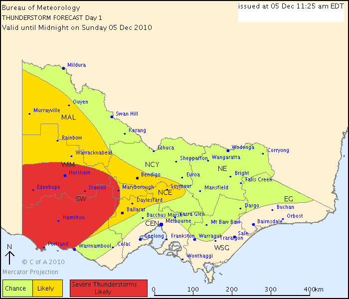
Re: Victoria: Rain/Storm event: 29th Nov - 5th Dec (Obs)
And the BoM's chart for today for reference. Looks very interesting for today as well!!
Australian Government Bureau of Meteorology
Victoria Regional Office
THUNDERSTORM FORECAST
Issued at 11:25 am Sunday, 5 December 2010,
Valid until midnight on Sunday, 5 December 2010.
Another unstable day across most of the State, with thunderstorms possible this afternoon and evening over all but coastal areas of central and eastern Victoria. The biggest risk is over the west and about the ranges where instability and lift is likely to be most significant. Any thunderstorms that develop today could become severe and produce heavy rainfall and flash flooding due to the very slow storm movement and fairly high moisture levels. Large hail is also a significant risk, while damaging wind gusts are only a low chance. Severe thunderstorms are most likely over the southwest in the area indicated.
Australian Government Bureau of Meteorology
Victoria
Fire Weather Briefing for Victoria
Issued at 11:58 am EDT on Sunday 5 December 2010.
Estimates Today:
The estimates today should provide generally good guidance. Thunderstorm
activity may produce local variations to wind speed and direction.
Weather Situation:
A high pressure system over the Tasman Sea is weakening. Another high pressure
system will pass south of Tasmania late today and will move over the Tasman Sea
on Monday. A low pressure trough over Western Australia will pass over South
Australia on Tuesday then reach central Victoria by late Wednesday.
24 Hour Rainfall to 9am:
Showers and thunderstorms affected mainly western and eastern districts over
the last 24 hours. The highest rainfall totals were 53mm at Mildura, followed
by 23mm at Stawell, most other totals were under 10mm.
Weather Today:
Drizzle patches over Gippsland. Isolated afternoon showers and thunderstorms
mainly over the west and about the ranges. Warm and humid with generally light
to moderate southeast to easterly winds, becoming fresh to locally strong near
the coast.
Australian Government Bureau of Meteorology
Victoria Regional Office
THUNDERSTORM FORECAST
Issued at 11:25 am Sunday, 5 December 2010,
Valid until midnight on Sunday, 5 December 2010.
Another unstable day across most of the State, with thunderstorms possible this afternoon and evening over all but coastal areas of central and eastern Victoria. The biggest risk is over the west and about the ranges where instability and lift is likely to be most significant. Any thunderstorms that develop today could become severe and produce heavy rainfall and flash flooding due to the very slow storm movement and fairly high moisture levels. Large hail is also a significant risk, while damaging wind gusts are only a low chance. Severe thunderstorms are most likely over the southwest in the area indicated.
Australian Government Bureau of Meteorology
Victoria
Fire Weather Briefing for Victoria
Issued at 11:58 am EDT on Sunday 5 December 2010.
Estimates Today:
The estimates today should provide generally good guidance. Thunderstorm
activity may produce local variations to wind speed and direction.
Weather Situation:
A high pressure system over the Tasman Sea is weakening. Another high pressure
system will pass south of Tasmania late today and will move over the Tasman Sea
on Monday. A low pressure trough over Western Australia will pass over South
Australia on Tuesday then reach central Victoria by late Wednesday.
24 Hour Rainfall to 9am:
Showers and thunderstorms affected mainly western and eastern districts over
the last 24 hours. The highest rainfall totals were 53mm at Mildura, followed
by 23mm at Stawell, most other totals were under 10mm.
Weather Today:
Drizzle patches over Gippsland. Isolated afternoon showers and thunderstorms
mainly over the west and about the ranges. Warm and humid with generally light
to moderate southeast to easterly winds, becoming fresh to locally strong near
the coast.
Jake - Senior AWF Forecaster
Feel free to send me a private message if you have any questions.
Feel free to send me a private message if you have any questions.
- droughtbreaker
- Supercell
- Reactions:
- Posts: 2844
- Joined: Wed Nov 25, 2009 7:50 pm
- Location: Mount Macedon, VIC, 520m asl
Re: Victoria: Rain/Storm event: 29th Nov - 5th Dec (Obs)
Cirrus anvil of that cell extending over the NW sky and into my area, so it is a decent sized storm.
Another tower going up close to here but further south of the one on radar currently.
Another tower going up close to here but further south of the one on radar currently.

Re: Victoria: Rain/Storm event: 29th Nov - 5th Dec (Obs)
Ah, go away storms! Promised the GF I'd have a day off haha
- Rhino
- Supercell
- Reactions:
- Posts: 1227
- Joined: Mon Nov 30, 2009 11:37 am
- Location: Carisbrook-Near Maryborough
Re: Victoria: Rain/Storm event: 29th Nov - 5th Dec (Obs)
That area around Daylesford and to it's west is going to explode, massive convection to my S-SW, hopefully will move nth.
Rhino.
Rhino.
Last edited by Rhino on Sun Dec 05, 2010 12:02 pm, edited 1 time in total.
- Jake Smethurst
- Supercell
- Reactions:
- Posts: 3583
- Joined: Mon Nov 23, 2009 8:49 pm
- Location: Cheltenham
Re: Victoria: Rain/Storm event: 29th Nov - 5th Dec (Obs)
Australian Government Bureau of Meteorology
Victoria Regional Office
TOP PRIORITY FOR IMMEDIATE BROADCAST
SEVERE THUNDERSTORM WARNING
for FLASH FLOODING and LARGE HAILSTONES
For people in parts of the Central, South West, Northern Country, North Central and Wimmera s.
Issued at 11:57 am Sunday, 5 December 2010.
Severe thunderstorms are likely to produce very heavy rainfall, flash flooding and large hailstones in the warning area over the next several hours. Locations which may be affected include Stawell, Ballarat, Ararat, Bendigo, Seymour, Daylesford, Maryborough, Castlemaine and Kyneton.
Jake - Senior AWF Forecaster
Feel free to send me a private message if you have any questions.
Feel free to send me a private message if you have any questions.
-
Supercellimpact
- Supercell
- Reactions:
- Posts: 1241
- Joined: Thu Oct 07, 2010 8:39 pm
- Location: Bendigo
Re: Victoria: Rain/Storm event: 29th Nov - 5th Dec (Obs)
That cell appears to be coming straight for bendigo.
- HarleyB
- Cumulonumbus Calvas
- Reactions:
- Posts: 839
- Joined: Sun Oct 10, 2010 9:39 pm
- Location: Wangaratta
Re: Victoria: Rain/Storm event: 29th Nov - 5th Dec (Obs)
Nice to see the BOM having it up nice and early in the piece today. Thumbs up