Thanks hillybilly. I'm at 195mtrs. I'll add to profile.hillybilly wrote:Rained all night in Sandy though mostly light. 48mm in the gauge and still rising. Expect to see quite a lot of water in the paddocks driving back to Melbourne today, though falls down here haven't been heavy enough to cause real problems (50mm falls are very common down here).
Great to see west Gippsland finally scoring. Been really lucking out lately in that region.
Hoping to see (about) 60mm in the gauge when I get home, which will put the event on about 80mm (give or take).
PS Ausmammal welcome on board. Good to have another local. What's your elevation?
Welcome New Members! We want to hear from you. Register, stop lurking and start posting!
Victoria: Rain/Storm Event (Obs) November 22-28 2010
Re: Victoria: Rain/Storm Event (Obs) November 22-28 2010
-
stratospear

- Supercell
- Reactions:
- Posts: 1261
- Joined: Sat Dec 19, 2009 9:38 am
- Location: Usually Bendigo
Re: Victoria: Rain/Storm Event (Obs) November 22-28 2010
Loddon Valley Hwy was borderline this morning with multiple water courses traversing the highway near Campbell's Forest. One or two near Bullock Crk are just about 4wd only now.
Many paddocks in flat areas are turning into lakes/rivers.
Many paddocks in flat areas are turning into lakes/rivers.
Re: Victoria: Rain/Storm Event (Obs) November 22-28 2010
droughtbreaker wrote:Well, the craziness just continues. Hard to keep up with all this now.
More solid rain overnight, ended up with close to 56mm for the 24hrs on top of 33.5mm the day before and 25mm on Thursday.
114.5mm all up for the entire event.
197.9mm for the month. Just a few showers away from 200mm for the month!368mm in the last 8 weeks.
1118.1mm for the year to date and the prospect of more heavy rain at times next week. This year just gets more and more insane. Eppalock full and spilling causing major flooding downstream. Werribee river flooded, Maribyrnong finally starting to indicate it can't take much more with minor flooding threatening Keilor and closer in to the city the river is rising to troubling levels but not yet threatening flood levels. Moderate flooding in Ballan as well.
You know what the funny thing is Andrew? They (BOM) have issued flood watches for the past 5 events for South Central Victoria and Melbourne but for some bizzare unknown reason they didn't put out one this time & now we have 3 of Melbournes largest river systems with some sort of flood warnings on them. really is it that suprising after all the rain of recent months that we do have these warnings and knowing the potential that this system could of delivered. Not good enough.
-
occluded

- Cumulonumbus Calvas
- Reactions:
- Posts: 611
- Joined: Tue May 04, 2010 3:26 pm
- Location: Mooroolbark 130m asl
Re: Victoria: Rain/Storm Event (Obs) November 22-28 2010
Just heard that a camping ground up Healesville way has been evacuated, looks like the Watts River is on the march again!Sniper wrote:As I type, a Flood Warning has just been issued for the Watts River @ Healesville (again!).
-
Blackee

- Site Admin/Moderator
- Reactions:
- Posts: 3869
- Joined: Tue Nov 24, 2009 8:57 pm
- Location: Elwood and Mansfield 370m
Re: Victoria: Rain/Storm Event (Obs) November 22-28 2010
VicRoads Road Closures as @ Sunday 28 November 11.04am
VicRoads advises that the roads listed below remain closed
as a result of floods and storm damage this weekend.
If you need to travel on roads you think may be affected and the road is not listed on this site, you can call the VicRoads Traffic Management Centre on 13 11 70 (24 hours a day, 7 days a week) for latest updates.
NORTHERN REGION
Bendigo-Murchinson Road - closed between the Midland Highway and Northern Highway due to flooding of Campaspe River
Bridgewater-Dunnolly Road - closed between the Wimmera Highway and the Calder Highway
Calder Highway - closed between Wedderburn and Charlton. Traffic heading southbound is being diverted via Boort. Traffic heading northbound is being diverted via the Loddon Valley Highway at Marong.
Calder Highway - closed at Marong
Pyreness Highway - closed at Muckleford Creek and at Newstead
Pyreness Highway - closed at Carisbrook at the intersection of Baringhup Road
(both closures on the Pyrenees Highway are between Maryborough and Castlemaine)
Wimmera Highway - closed at Tarnagulla and Logan due to flooding of Murphy's Creek
Loddon Shire - local roads closed
Baringhup Road - closed at Cairn Curran Reservior
Eddington Road - closed between Eddington and Eastville
Northern Grampians Shire - local roads closed
Cherry Tree Road - closed at Archdale Junction where the bridge has washed out
WESTERN METROPOLITAN MELBOURNE
Dohertys Road, Tarneit - closed between Tarneit Road and Derrimut Road
Cottrell Street, Werribee - closed between Market Street and Werribee Street
NORTH EASTERN METROPOLITAN MELBOURNE
Healesville-Yarra Glen Road - closed at various locations in and around Yarra Glen. Traffic management signage is in place and some access roads to Yarra Glen will be closed. Flooding may also restrict access to the Yarra Glen bypass.
Maroondah Highway - closed at Powelltown. Remains open elsewhere however flooding and damage has resulted in lanes being closed at two locations:
Lilydale - between Clarke Street and Olinda Creek Bridge
Yarra Glen - at Healesville-Yarra Glen Road
Melba Highway - remains open but flooding and damage have restricted access to one lane in some parts (in the area of Mt Slide). Drivers to reduce speed and follow any on-road signage.
Mansfield 370m and Elwood
- Lily
- Supercell
- Reactions:
- Posts: 4014
- Joined: Wed Nov 25, 2009 10:29 pm
- Location: Rowville/Lysterfield
Re: Victoria: Rain/Storm Event (Obs) November 22-28 2010
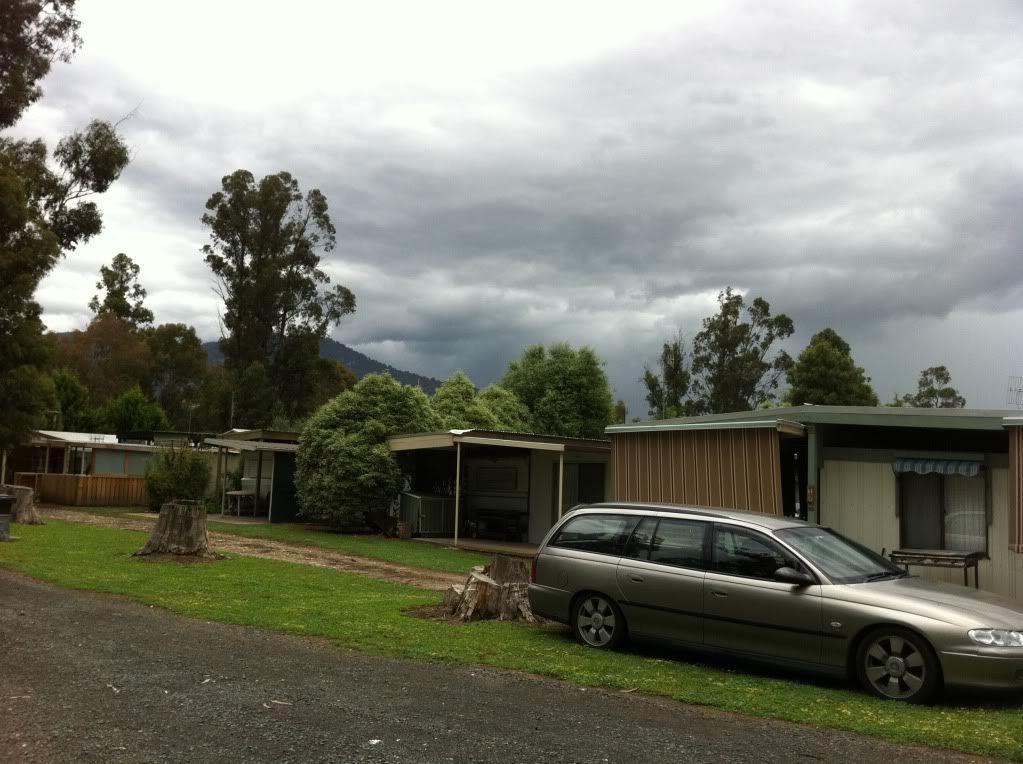
Well hello all! Just back from a hairy trip home from Eildon, went up yesterday morning expecting to have internet coverage but got up there to NOTHING! Very frustrating!
Storms came through early afternoon around 1-2pm, most of it slid just slightly to the west of us but we got the edge of it. Some lowerings in the cloud that I tried to get pics of, am currently downloading them so if they're any good will post. After the initial storm passed, the rain continued ALL afternoon, then ALL night. We were up at 3am to a vomiting child (heaven) and it was still raining, by 7am this morning when we got up it had finally abated, but the flooding around the park was substantial. A new building area in the park with a retaining wall has collapsed, campers very wet and grumpy too! Rain gauge well and truly overflowed so I can't accurately give a picture of how much we had there, but I would suggest in excess of 50-60mm.
Trip home was interesting to say the least, we came home via Alex and Yea. Ultima Thule creek at Alex is running very high and very strong, a footbridge has been washed away (pics to follow). A lot of minor flooding to creeks all the way through from Eildon to Yea, some creeks had burst their banks.
Drove through flood waters just outside of Molesworth, I would imagine that area would be getting closed soon as the flood heights continue to rise through the day, again pics to follow. Between Yea and Yarra Glen, some creeks have burst their banks but are not as yet causing any issues to the roads (though a couple of them were very close to flooding the roads when we went through). Melba Hwy between Castella and Dixons Creek is partially blocked due to land slips, then down into Yarra Glen there is substantial flooding throughout low lying areas.
Will post pics later on today, but glad to be home and get my daughter into bed where she should be
- Jake Smethurst
- Supercell
- Reactions:
- Posts: 3583
- Joined: Mon Nov 23, 2009 8:49 pm
- Location: Cheltenham
Re: Victoria: Rain/Storm Event (Obs) November 22-28 2010
Well hello everyone! I have been away since late yesterday and just got back!! Checked the radar and wowzers!! AMAZING rainfall band affected central and eastern parts of the state overnight. I am getting reports this morning of flooded conditions across all of these regions, so people stay safe on the roads if you need to travel. News has been reporting some rescues overnight thanks to flooded roads etc ... some MASSIVE falls through central and eastern parts of the state in the past 24 hours. Trully amazing, just goes to show what this cold air is doing this year!! (Thanks AV !!  )
)
We have missed most of the rainfall (as has most of western Victoria), with about 37mm for the event. Nontheless, that is a very good fall and will keep things green lasting into the Summer.
A reminder to keep track of the forecasts on the AWF and warnings, or travel on over the BoM website.
We have missed most of the rainfall (as has most of western Victoria), with about 37mm for the event. Nontheless, that is a very good fall and will keep things green lasting into the Summer.
A reminder to keep track of the forecasts on the AWF and warnings, or travel on over the BoM website.
Jake - Senior AWF Forecaster
Feel free to send me a private message if you have any questions.
Feel free to send me a private message if you have any questions.
-
Anthony Violi

- Supercell
- Reactions:
- Posts: 2652
- Joined: Mon Nov 23, 2009 9:03 pm
- Location: Lilydale
- Contact:
Re: Victoria: Rain/Storm Event (Obs) November 22-28 2010
Was at Healesville Yarra Glen Road last night, knew it wouldnt been long after i left there at midnight as there was water everywhere.
http://www.therealworldweatherforum.com" onclick="window.open(this.href);return false;
avweatherforecasts.com
avweatherforecasts.com
-
Supercellimpact

- Supercell
- Reactions:
- Posts: 1241
- Joined: Thu Oct 07, 2010 8:39 pm
- Location: Bendigo
Re: Victoria: Rain/Storm Event (Obs) November 22-28 2010
At eppalock spillway is going strong . Pics later .
-
Karl Lijnders

- Tornadic Supercell
- Reactions:
- Posts: 5771
- Joined: Sun Nov 22, 2009 11:17 pm
- Location: Knoxfield, Victoria
Re: Victoria: Rain/Storm Event (Obs) November 22-28 2010
Fantastic to hear SCI. Cannot wait for pictures!!!Supercellimpact wrote:At eppalock spillway is going strong . Pics later .
Drizzly showers coming through at regular intervals here. 1mm since 9am!
Former Owner - The Australian Weather Forum. Email me anytime - weatherman1000@hotmail.com
- Lily
- Supercell
- Reactions:
- Posts: 4014
- Joined: Wed Nov 25, 2009 10:29 pm
- Location: Rowville/Lysterfield
Re: Victoria: Rain/Storm Event (Obs) November 22-28 2010
92mm here since Thursday!
-
Karl Lijnders
- Tornadic Supercell
- Reactions:
- Posts: 5771
- Joined: Sun Nov 22, 2009 11:17 pm
- Location: Knoxfield, Victoria
Re: Victoria: Rain/Storm Event (Obs) November 22-28 2010
Welcome RG!! Great rainfall!!!
I think we will see similar falls over the course of this week.
I think we will see similar falls over the course of this week.
Former Owner - The Australian Weather Forum. Email me anytime - weatherman1000@hotmail.com
- HarleyB
- Cumulonumbus Calvas
- Reactions:
- Posts: 839
- Joined: Sun Oct 10, 2010 9:39 pm
- Location: Wangaratta
Re: Victoria: Rain/Storm Event (Obs) November 22-28 2010
As I mentioned earlier, the Goulburn has broken its banks for the second time this year...
The actual river bank is about 30 metres out of the picture...
- DSCI0061 (2).JPG (136.44 KiB) Viewed 5517 times
-
NoRelationToNed

- Cumulus
- Reactions:
- Posts: 51
- Joined: Wed Nov 25, 2009 8:40 pm
- Location: Kerang (home) Cohuna (work)
Re: Victoria: Rain/Storm Event (Obs) November 22-28 2010
http://plixi.com/photos/original/59608348" onclick="window.open(this.href);return false;
Found this pic of Eppalock spillway on Twitter:
Found this pic of Eppalock spillway on Twitter:
...from the border of the Mallee and the Northern Country, just south of the Murray.
- Jake Smethurst
- Supercell
- Reactions:
- Posts: 3583
- Joined: Mon Nov 23, 2009 8:49 pm
- Location: Cheltenham
Re: Victoria: Rain/Storm Event (Obs) November 22-28 2010
My own thunderstorm charts updated here http://australianweather.yolasite.com/ts-charts.php
Australian Government Bureau of Meteorology
Victoria Regional Office
THUNDERSTORM FORECAST
Issued at 11:17 am Sunday, 28 November 2010,
Valid until midnight on Sunday, 28 November 2010.
A trough has moved through all but the far east of the State. High moisture levels persist in the far northeast. There is a risk of afternoon storms in that area and a small chance of heavy rainfall.
Australian Government Bureau of Meteorology
Victoria
Fire Weather Briefing for Victoria
Issued at 10:50 am EDT on Sunday 28 November 2010.
Estimates Today:
The fire weather forecast should provide generally good guidance today,
although temperatures may fall a couple of degrees below the forecast this
afternoon.
Weather Situation:
A low pressure trough over eastern Victoria will continue to move slowly
eastwards during Sunday. The low pressure trough will drift westwards across on
Monday and Tuesday and is still expected to linger over western Victoria on
Wednesday.
24 Hour Rainfall to 9am:
Rain and thunderstorm activity produced rainfall in all districts over the last
24 hours with totals ranging from 5 to 20mm of the far west and far east, to 20
to 70mm elsewhere. There were numerous higher totals about the central and
eastern ranges, the highest being 97mm at Mt Buffalo Chalet, followed by 91mm
at Dohertys, 90mm at Upper Buckland, 89mm at Whitlands, 85mm at Cheshunt and
Lake william Hovell and 82mm at Mt Hotham and Charnwood.
Weather Today:
Scattered showers over southern and mountain areas becoming isolated in the
west. The chance of thunderstorms this afternoon in the far east. Fine over the
northwest. Cool, fresh southerly winds extending throughout, locally strong
about the central and Gippsland coast.
Australian Government Bureau of Meteorology
Victoria Regional Office
THUNDERSTORM FORECAST
Issued at 11:17 am Sunday, 28 November 2010,
Valid until midnight on Sunday, 28 November 2010.
A trough has moved through all but the far east of the State. High moisture levels persist in the far northeast. There is a risk of afternoon storms in that area and a small chance of heavy rainfall.
Australian Government Bureau of Meteorology
Victoria
Fire Weather Briefing for Victoria
Issued at 10:50 am EDT on Sunday 28 November 2010.
Estimates Today:
The fire weather forecast should provide generally good guidance today,
although temperatures may fall a couple of degrees below the forecast this
afternoon.
Weather Situation:
A low pressure trough over eastern Victoria will continue to move slowly
eastwards during Sunday. The low pressure trough will drift westwards across on
Monday and Tuesday and is still expected to linger over western Victoria on
Wednesday.
24 Hour Rainfall to 9am:
Rain and thunderstorm activity produced rainfall in all districts over the last
24 hours with totals ranging from 5 to 20mm of the far west and far east, to 20
to 70mm elsewhere. There were numerous higher totals about the central and
eastern ranges, the highest being 97mm at Mt Buffalo Chalet, followed by 91mm
at Dohertys, 90mm at Upper Buckland, 89mm at Whitlands, 85mm at Cheshunt and
Lake william Hovell and 82mm at Mt Hotham and Charnwood.
Weather Today:
Scattered showers over southern and mountain areas becoming isolated in the
west. The chance of thunderstorms this afternoon in the far east. Fine over the
northwest. Cool, fresh southerly winds extending throughout, locally strong
about the central and Gippsland coast.
Jake - Senior AWF Forecaster
Feel free to send me a private message if you have any questions.
Feel free to send me a private message if you have any questions.
Re: Victoria: Rain/Storm Event (Obs) November 22-28 2010
Not exactly sure how to embed it in here but here is the local footy ground at Marong covered in water from the Bullock Creek
" onclick="window.open(this.href);return false;"
" onclick="window.open(this.href);return false;"
-
fireone

- Cumulus
- Reactions:
- Posts: 82
- Joined: Sat Oct 30, 2010 11:51 am
- Location: Alexandra Vic. 3714 (www.alexandraweather.org)
- Contact:
Re: Victoria: Rain/Storm Event (Obs) November 22-28 2010
Goulburn Valley Highway is closed at Cathkin due to flooding of the Home Creek that flows into the Goulburn. Alternative route via Whanregarwen Road from Molesworth (heading north) thru Alexandra or
thru Alexandra (south bound).
A foot bridge (near Jack Shiel Gardens, Perkins Sreet, near Shire Office), Alexandra has been swept away in the flood waters. Believed to have happened around 4am Sunday morning.
The bridge is over the UT Creek that runs thru Alexandra. Last time this bridge devastation happened was in the early 1970`s. when the same bridge disappeared. 100mm at Alexandra in the 48 hours and upstream in the UT Creek catchement, near Eildon Fire Tower, 135mm.
FIREONE, Alexandra. { North Central } Vic.
Re: Victoria: Rain/Storm Event (Obs) November 22-28 2010
Upwey FS 10.7mm since 12am, Belgrave (Monbulk Rd) 36.6mm since 12am. Both today.
These figures btw I assume to be a daily figures and not since 9am. There are no indications only they have daily listed and no other information.
Note: The reason I'm listing both these is because I am in the middle of them.
These figures btw I assume to be a daily figures and not since 9am. There are no indications only they have daily listed and no other information.
Note: The reason I'm listing both these is because I am in the middle of them.
- Lily
- Supercell
- Reactions:
- Posts: 4014
- Joined: Wed Nov 25, 2009 10:29 pm
- Location: Rowville/Lysterfield
Re: Victoria: Rain/Storm Event (Obs) November 22-28 2010
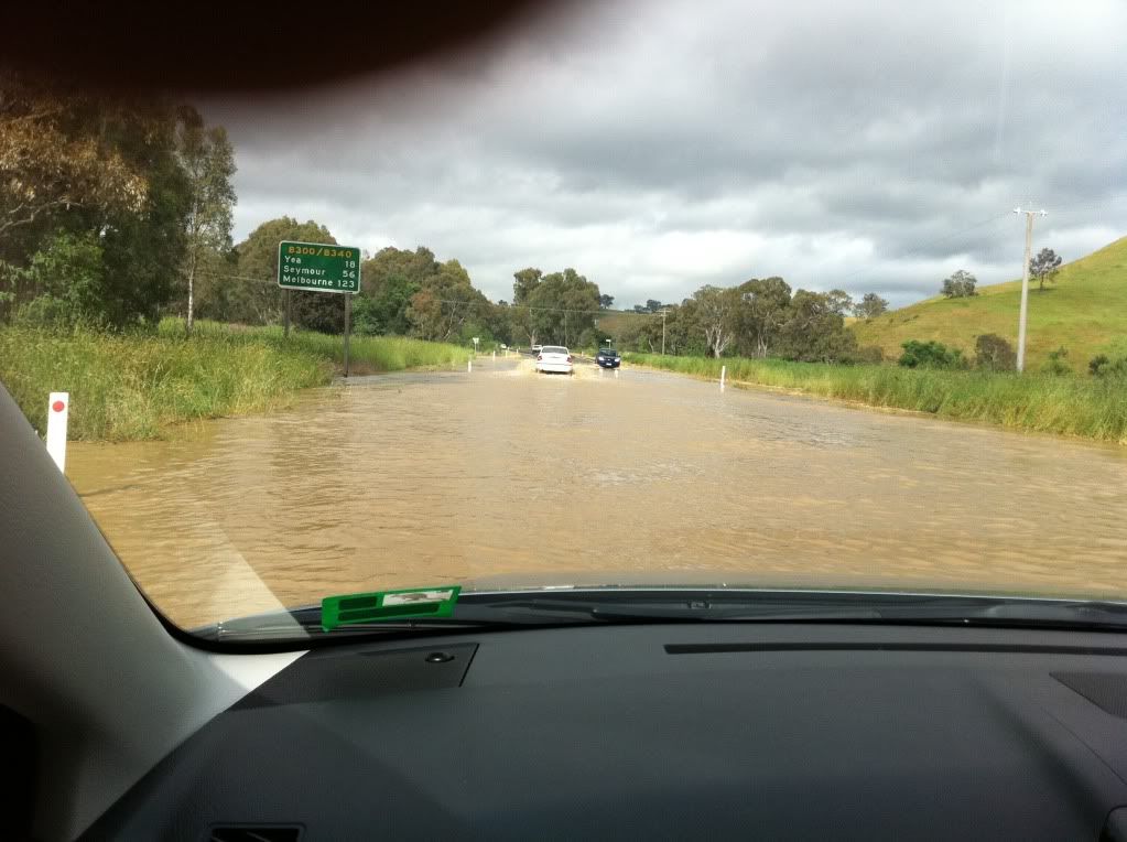
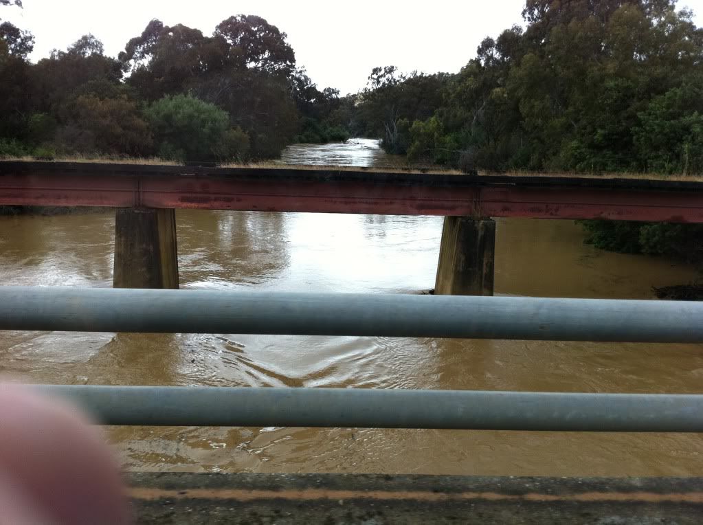
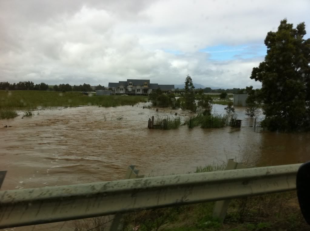
And here's some pics from our trip home today, including Ultima Thule footbridge that's washed away (as mentioned in Fireone's post). Also pics of Molesworth/Cathkin flooding that we drove through. As I said in my earlier post, the road would have to be closed soon as it was over the road for some distance and was rising.
I'll start a new thread and link here in a minute, don't want to clog this thread up with too many pics, but here's some to give an idea of our trip home. Quality's not crash hot, I apologise, were all taken on iPhone as I didn't take the camera for once My husband has a habit of getting his fingers in the way too lol.
Storm as it came through yesterday afternoon, mostly went just to our west:
UT Creek in Alex, including what's left of the footbridge. You can see in the photo the level the waters had risen to overnight by the debris on the banks.
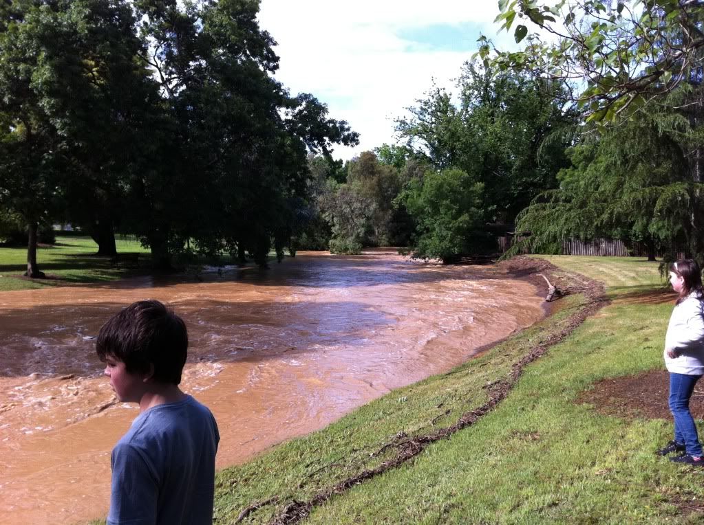
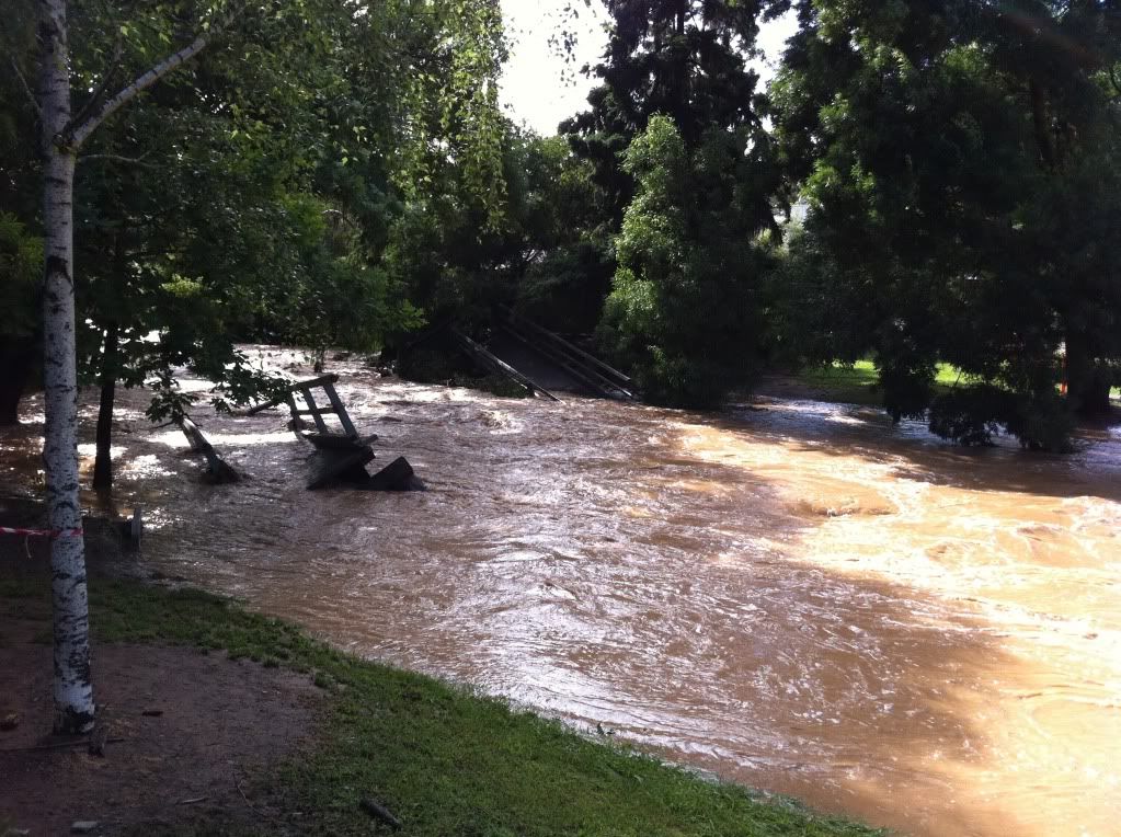
Floods we drove through just outside of Molesworth (Cathkin):
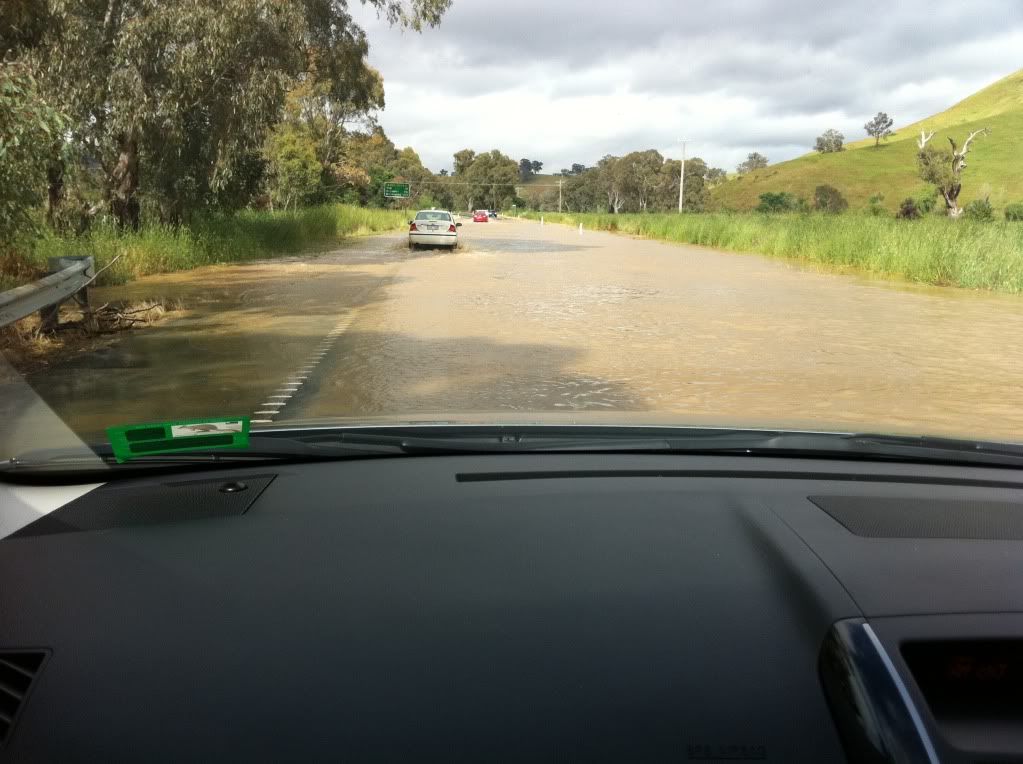
Goulburn at Molesworth:
Flooding at Yarra Glen:
I'll start a new thread and link here in a minute, don't want to clog this thread up with too many pics, but here's some to give an idea of our trip home. Quality's not crash hot, I apologise, were all taken on iPhone as I didn't take the camera for once
Storm as it came through yesterday afternoon, mostly went just to our west:
UT Creek in Alex, including what's left of the footbridge. You can see in the photo the level the waters had risen to overnight by the debris on the banks.
Floods we drove through just outside of Molesworth (Cathkin):
Goulburn at Molesworth:
Flooding at Yarra Glen:

Re: Victoria: Rain/Storm Event (Obs) November 22-28 2010
Final event totals for here (from Thursday through today)...
Home: 102mm
Bendigo Ap: 86.2mm
Home: 102mm
Bendigo Ap: 86.2mm