Welcome New Members! We want to hear from you. Register, stop lurking and start posting!
Victoria: Rain/Storm Event (Obs) November 22-28 2010
-
Anthony Violi

- Supercell
- Reactions:
- Posts: 2652
- Joined: Mon Nov 23, 2009 9:03 pm
- Location: Lilydale
- Contact:
Re: Victoria: Rain/Storm Event (Obs) November 22-28 2010
Out at the lovely Train Trak Winery in Coldstream for a wedding...seriously Pour down here. The band is slow and tilting a little so good totals through Central, the only question remains does it tilt and wrap or just meander it's way through..
http://www.therealworldweatherforum.com" onclick="window.open(this.href);return false;
avweatherforecasts.com
avweatherforecasts.com
-
Karl Lijnders

- Tornadic Supercell
- Reactions:
- Posts: 5771
- Joined: Sun Nov 22, 2009 11:17 pm
- Location: Knoxfield, Victoria
Re: Victoria: Rain/Storm Event (Obs) November 22-28 2010
Storm chase from yesterday....
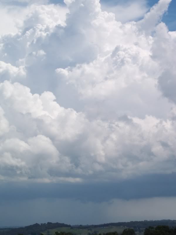
This was the Melbourne AP cell as it developed to maturity...From Ferntree Gully.
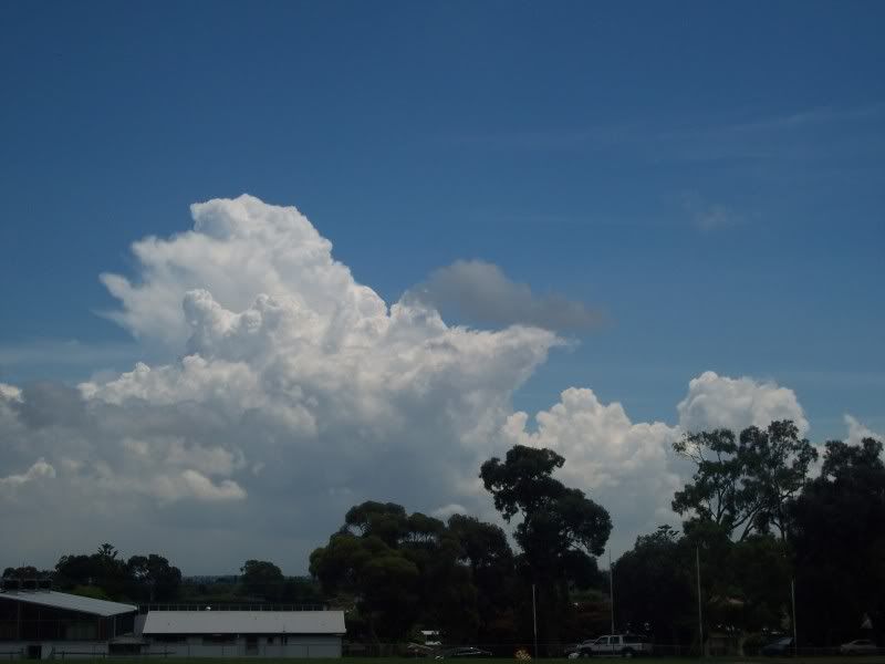
This was taken in Lilydale as the cell developed into a full blown thunderstorm over the NW suburbs. It dominated the environment
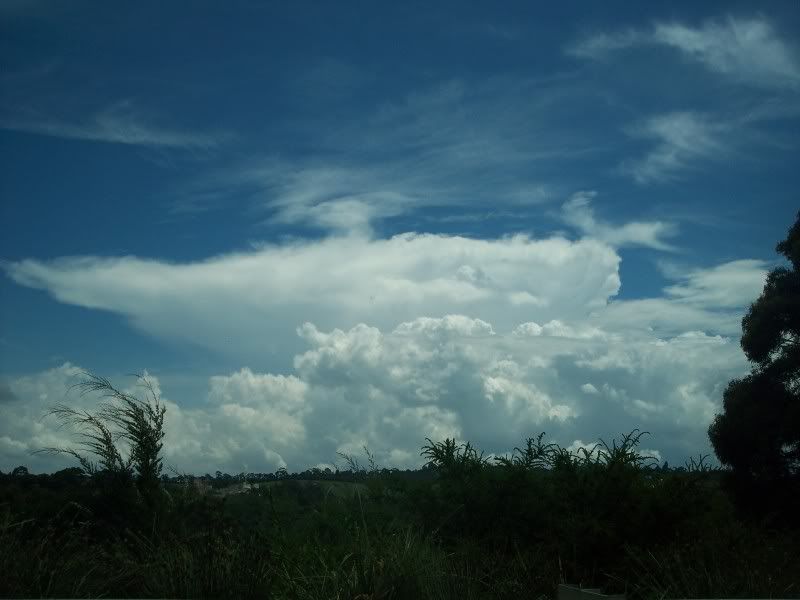
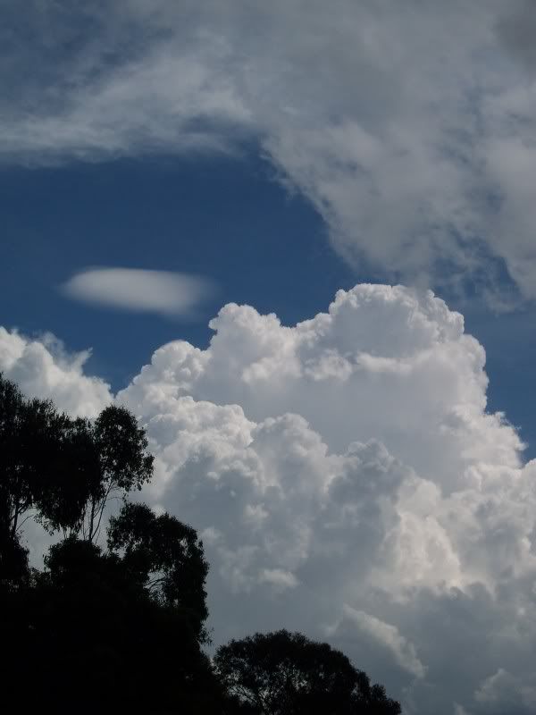
I travelled to Sugarloaf and this was taken on the dam wall. My favourite place in this type of seabreeze convergence.
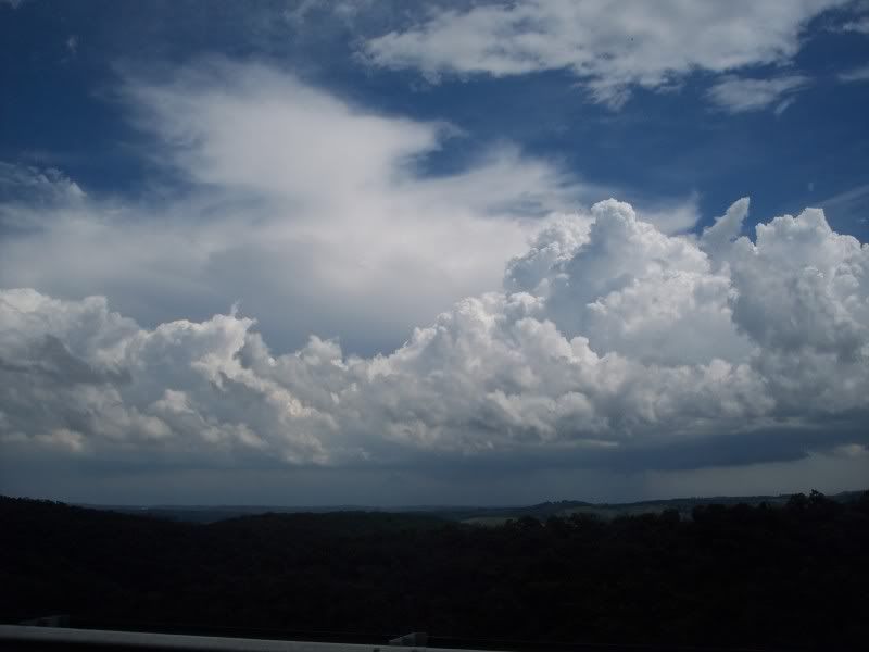
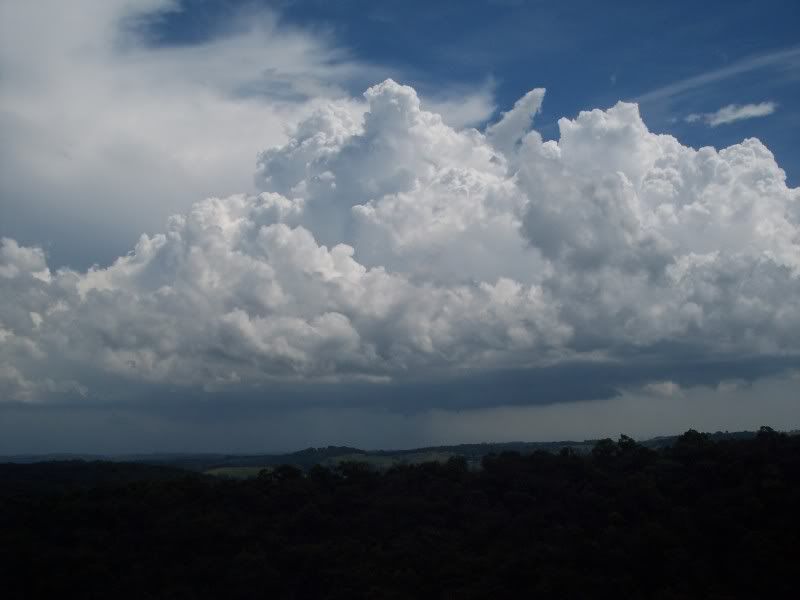
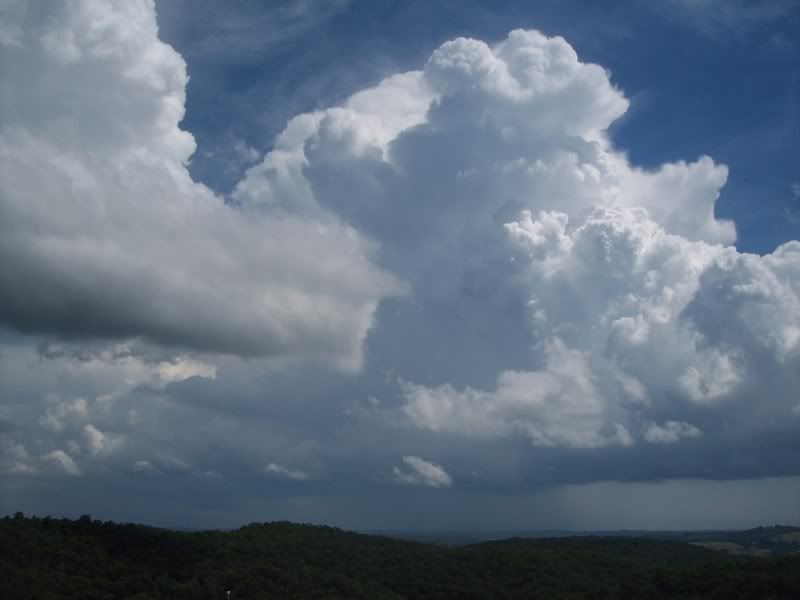
This core was the one that dumped 20-40mm over the Footscray region.
The fresh convection that then spawned the new and severe multicell over the inner eastern suburbs and then went on to pound the SE/E suburbs.
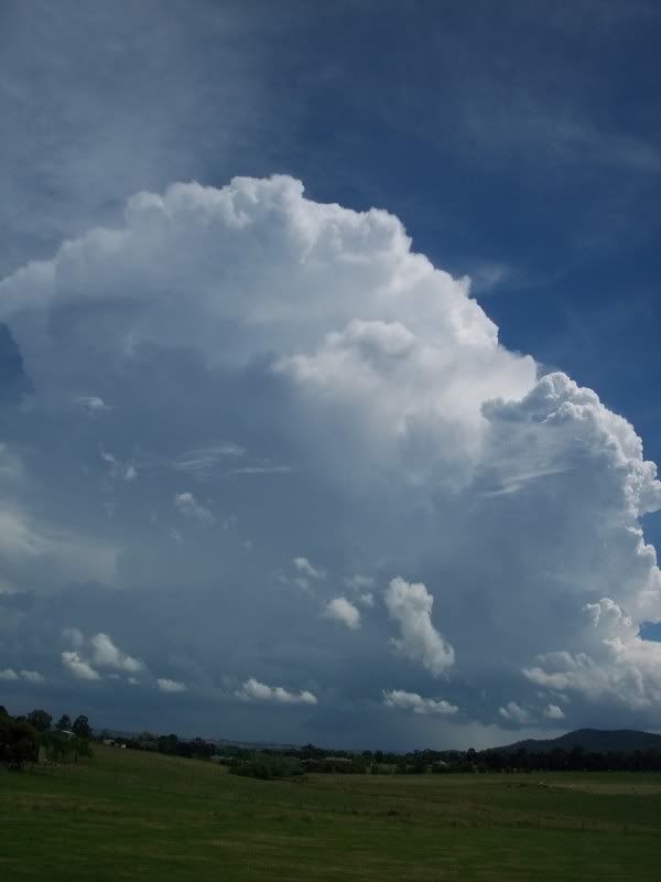
The full blown cell over my area and areas towards Ringwood which copped around 40mm yesterday afternoon.
This had three lowerings on it and a lovely rainfoot and hail shaft.
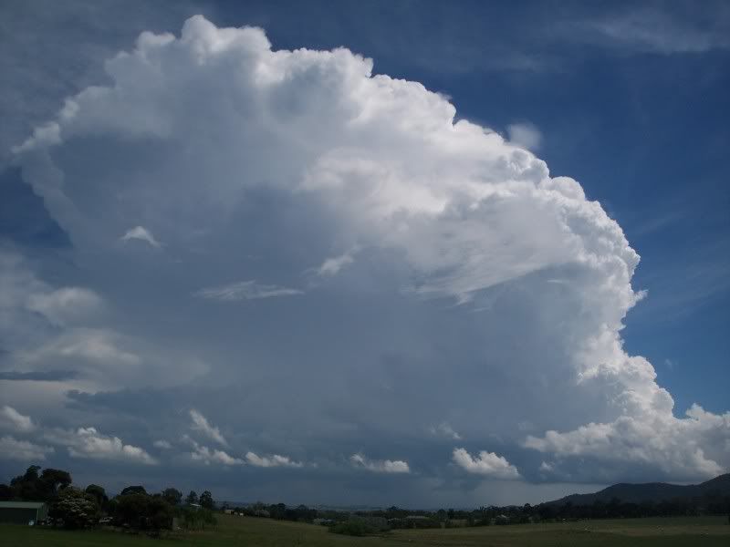
Not a bad afternoon yesterday!!
This was the Melbourne AP cell as it developed to maturity...From Ferntree Gully.
This was taken in Lilydale as the cell developed into a full blown thunderstorm over the NW suburbs. It dominated the environment
I travelled to Sugarloaf and this was taken on the dam wall. My favourite place in this type of seabreeze convergence.
This core was the one that dumped 20-40mm over the Footscray region.
The fresh convection that then spawned the new and severe multicell over the inner eastern suburbs and then went on to pound the SE/E suburbs.
The full blown cell over my area and areas towards Ringwood which copped around 40mm yesterday afternoon.
This had three lowerings on it and a lovely rainfoot and hail shaft.
Not a bad afternoon yesterday!!
Former Owner - The Australian Weather Forum. Email me anytime - weatherman1000@hotmail.com
-
dagget

- Cumulonimbus
- Reactions:
- Posts: 480
- Joined: Sun Nov 29, 2009 10:35 pm
- Location: Trentham (705m ASL)
Re: Victoria: Rain/Storm Event (Obs) November 22-28 2010
Amazing how localised the weather is, we have been having decent rain for a bit too long now so you are quite welcome to it.droughtbreaker wrote:Finally getting some decent rain here after light dribbly stuff for most of the day.
EC indicates some half decent rain overnight before mostly clearing Sunday morning. BOM seems to be a little more enthusiastic atm with rain in central areas until midday but it won't be for here.
Re: Victoria: Rain/Storm Event (Obs) November 22-28 2010
27mm for the event here 5km nth of Drouin, West Gippsland - very low cloud and light drizzle at present.
-
Petros

- Supercell
- Reactions:
- Posts: 2005
- Joined: Tue Dec 01, 2009 6:25 pm
- Location: Maffra, Gippsland, Vic
Re: Victoria: Rain/Storm Event (Obs) November 22-28 2010
Welcome RomG, please let us know your location so the rain totals mean something to us. 
Still calm with light steady rain here.
Still calm with light steady rain here.
- Monbulkian
- Cumulonimbus
- Reactions:
- Posts: 192
- Joined: Thu Nov 11, 2010 9:42 pm
- Location: Monbulk
Re: Victoria: Rain/Storm Event (Obs) November 22-28 2010
Fantastic photos from all and great updates from across the state. After a very frustrating day and night yesterday I awoke to rain. I haven't been home all day, checked the rain gauge at 7:30pm and we are sitting on 19mm since 11:30 last night. Total for the event 40.5mm. It is currently raining quite heavily so I'm sure that has increased but I can't get to the rain guage at the moment.
Driving up to Sydney in the morning so I won't be posting for a couple of days. Will give an update of the weather on my travels and a rain update from Monbulk upon my return
Driving up to Sydney in the morning so I won't be posting for a couple of days. Will give an update of the weather on my travels and a rain update from Monbulk upon my return
- droughtbreaker
- Supercell
- Reactions:
- Posts: 2844
- Joined: Wed Nov 25, 2009 7:50 pm
- Location: Mount Macedon, VIC, 520m asl
Re: Victoria: Rain/Storm Event (Obs) November 22-28 2010
Well, fortunes have turned rapidly here and we have now had 26mm for day. Probably about 20mm in the last 2 hours and more to come by the looks of things.
- droughtbreaker
- Supercell
- Reactions:
- Posts: 2844
- Joined: Wed Nov 25, 2009 7:50 pm
- Location: Mount Macedon, VIC, 520m asl
Re: Victoria: Rain/Storm Event (Obs) November 22-28 2010
The location is in the name.Petros wrote:Welcome RomG, please let us know your location so the rain totals mean something to us.
Still calm with light steady rain here.
- Rhino
- Supercell
- Reactions:
- Posts: 1227
- Joined: Mon Nov 30, 2009 11:37 am
- Location: Carisbrook-Near Maryborough
Re: Victoria: Rain/Storm Event (Obs) November 22-28 2010
Looks like about it for here so topped out with 88mm for the system, alot more than we needed but mother nature can be nasty at time's. Next week looks wet too so just does'nt stop when you don't really need much. 
Rhino.
Rhino.
- droughtbreaker
- Supercell
- Reactions:
- Posts: 2844
- Joined: Wed Nov 25, 2009 7:50 pm
- Location: Mount Macedon, VIC, 520m asl
Re: Victoria: Rain/Storm Event (Obs) November 22-28 2010
Have got 85.9mm now for the system (last three to four days) all of a sudden. It has been a really interesting system with lots of local rain areas and quite patchy, but eventually most people are scoring some really good periods of rain.
More incredibly I'm just about to tick over 170mm for the month after 170.1mm last month. I'll have to check but it would have to be one of the wettest 2 month periods in this area since 1974. If I could fluke another 30mm by Tuesday morning then it would be only the third 200mm+ month here since 1974. The big wet continues.
1089.6mm for the year now.
-
Petros
- Supercell
- Reactions:
- Posts: 2005
- Joined: Tue Dec 01, 2009 6:25 pm
- Location: Maffra, Gippsland, Vic
Re: Victoria: Rain/Storm Event (Obs) November 22-28 2010
Cloud level has lowered here and bearing down from the NNE. 7.5mm since 4:30pm and continuing on with the same light steady rain. Baro inched up from 1007 to 1010 hPa in this time so not feeling confident that the trought is going to move back over us tonight.
-
occluded

- Cumulonumbus Calvas
- Reactions:
- Posts: 611
- Joined: Tue May 04, 2010 3:26 pm
- Location: Mooroolbark 130m asl
Re: Victoria: Rain/Storm Event (Obs) November 22-28 2010
Just light drizzle tending to showers under a flat grey sky at the moment, most of the heavier stuff appears to be sitting on or north of the ranges for now at least?
Nearest AWS at Viewbank showing only 4.4mm since 9am - I have it on good authority that someone in the family will be getting a manual rainguage for his birthday, so I'll be able to provide some more localised readings soon
Quiet weekend with only two calls for tree down so far, both of which were taken care of by other agencies.
Just looked at the WZ 7-day forecast and first time in a while that I've seen rain or showers progged for all seven days?!
- droughtbreaker
- Supercell
- Reactions:
- Posts: 2844
- Joined: Wed Nov 25, 2009 7:50 pm
- Location: Mount Macedon, VIC, 520m asl
Re: Victoria: Rain/Storm Event (Obs) November 22-28 2010
I've actually had almost 40% of my annual average in the last 8 weeks.  This is a truly phenomenal year, can't stress it enough.
Rain has eased back again but it will be interesting to see what happens overnight.
Rain has eased back again but it will be interesting to see what happens overnight.
-
AUSSKY

- Storm Chaser
- Reactions:
- Posts: 538
- Joined: Wed Nov 25, 2009 11:59 pm
- Location: Trentham (700m ASL)
- Contact:
Re: Victoria: Rain/Storm Event (Obs) November 22-28 2010
Hi all,
chasing flash floods through the central ranges, played around with the trough, some roads near closed north of Heathcote...1 farmer reckoned they got 83mm out of a storm the night before last in just over an hour...and...got a 'tornado' at Shepparton..........will post a pic soon.......Clyve Herbert & Jane ONeill
PS: 119mm for the event so far in Trentham, road north of the lagoon under water, Trentham Falls thundering......Upper Coliban in spate!!!!!! photos of these things too sooon....
Australian Sky & Weather (AUSSKY)
Victoria - The State of Drizzle & Occasional Tornadoes
(1999 -2016)
Victoria - The State of Drizzle & Occasional Tornadoes
(1999 -2016)
-
Karl Lijnders
- Tornadic Supercell
- Reactions:
- Posts: 5771
- Joined: Sun Nov 22, 2009 11:17 pm
- Location: Knoxfield, Victoria
Re: Victoria: Rain/Storm Event (Obs) November 22-28 2010
Some wonderful rainy drizzle still falling now. 19mm since 9am back at home with good rain here in the SE suburbs at the moment.
Should see further falls of 10mm at this stage, possibly 25mm.
Look forward to your spread of pictures J&C.
Should see further falls of 10mm at this stage, possibly 25mm.
Look forward to your spread of pictures J&C.
Former Owner - The Australian Weather Forum. Email me anytime - weatherman1000@hotmail.com
Re: Victoria: Rain/Storm Event (Obs) November 22-28 2010
How is it looking compared to the amount of water that we had in the September event Rhino??Rhino wrote:Looks like about it for here so topped out with 88mm for the system, alot more than we needed but mother nature can be nasty at time's. Next week looks wet too so just does'nt stop when you don't really need much.
Rhino.
I know further over towards Bendigo we have a lot more water flowing than during that event.
-
AUSSKY
- Storm Chaser
- Reactions:
- Posts: 538
- Joined: Wed Nov 25, 2009 11:59 pm
- Location: Trentham (700m ASL)
- Contact:
Re: Victoria: Rain/Storm Event (Obs) November 22-28 2010
If anyone wants the name of this tatooist in Shepparton (who is absolutely brilliant)...just let Clyve know....
- This is the tornado that Clyve got at Shepparton!! <hehehehe>
- 271110jon188t.jpg (75.2 KiB) Viewed 5345 times
Australian Sky & Weather (AUSSKY)
Victoria - The State of Drizzle & Occasional Tornadoes
(1999 -2016)
Victoria - The State of Drizzle & Occasional Tornadoes
(1999 -2016)
-
Karl Lijnders
- Tornadic Supercell
- Reactions:
- Posts: 5771
- Joined: Sun Nov 22, 2009 11:17 pm
- Location: Knoxfield, Victoria
Re: Victoria: Rain/Storm Event (Obs) November 22-28 2010
Oh very nice!!! LOL!
Might have to get one. Rain on radar is underestimating here.
Keep an eye on the middle level deck that is dropping in the SW.
Might have to get one. Rain on radar is underestimating here.
Keep an eye on the middle level deck that is dropping in the SW.
Former Owner - The Australian Weather Forum. Email me anytime - weatherman1000@hotmail.com
Re: Victoria: Rain/Storm Event (Obs) November 22-28 2010
Upwey Firestation 23.11mm, Belgrave (along Mondbulk Rd) 16.26mm today since 12am. I''m in between both so I might just say I've had about 19 and a bit mm give or take 3 and a bit  . I'd get a rain guage but to many trees around to be effective. And this smiley looks so funnny>
  .......
-
Karl Lijnders
- Tornadic Supercell
- Reactions:
- Posts: 5771
- Joined: Sun Nov 22, 2009 11:17 pm
- Location: Knoxfield, Victoria
Re: Victoria: Rain/Storm Event (Obs) November 22-28 2010
Nice to have you Aus!! We needed that location covered!!
Still coming down with 21mm now with thick rain continuing.
Still coming down with 21mm now with thick rain continuing.
Former Owner - The Australian Weather Forum. Email me anytime - weatherman1000@hotmail.com