
Welcome New Members! We want to hear from you. Register, stop lurking and start posting!
New Years Week: becoming hot and humid with possible storms
- norfolk
- Supercell
- Reactions:
- Posts: 2024
- Joined: Thu Nov 26, 2009 7:03 pm
- Location: Caroline Springs, western Melbourne
- Contact:
Re: New Years Week: becoming hot and humid with possible storms
well all up about 10mm for the even is awesome. Ground is wet now dur to today's early drizzle which has passed. Cloudy and cool now which is nice but yes quite humid. Will only reach 27c today if winds turn to north or sum comes out, not sure if I can see that happening though.
- I_Love_Storms
- Supercell
- Reactions:
- Posts: 2812
- Joined: Wed Dec 02, 2009 2:01 pm
- Location: Hawthorn
Re: New Years Week: becoming hot and humid with possible storms
Dewpoints are looking very attractive today...
Coldstream 24/18.6 at 72% humidity
I would love to see the dewpoints get into the 20s around here and the temp peak above 30.
Coldstream 24/18.6 at 72% humidity
I would love to see the dewpoints get into the 20s around here and the temp peak above 30.
-
Karl Lijnders

- Tornadic Supercell
- Reactions:
- Posts: 5771
- Joined: Sun Nov 22, 2009 11:17 pm
- Location: Knoxfield, Victoria
Re: New Years Week: becoming hot and humid with possible storms
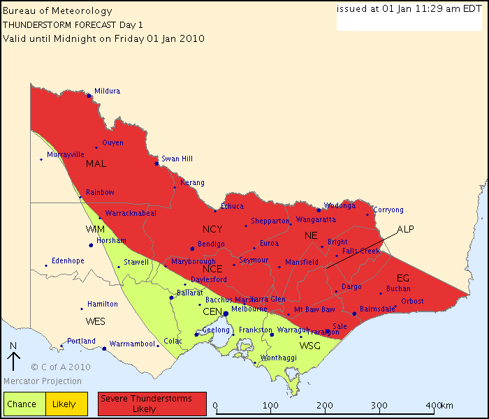
Australian Government Bureau of Meteorology
Victoria Regional Office
THUNDERSTORM FORECAST
Issued at 11:29 am Friday, 1 January 2010,
Valid until midnight on Friday, 1 January 2010.
An inland trough across central parts of the state will produce scattered thunderstorms this afternoon and evening across northern and eastern districts. These thunderstroms are likely to be severe with possible flash flooding, damaging winds and hail. There is also a chance of middle-level thunderstorms over southern central districts at night as the trough moves eastwards also with the risk of damaging winds, flash flooding and hail
Former Owner - The Australian Weather Forum. Email me anytime - weatherman1000@hotmail.com
- adon
- Cumulonumbus Calvas
- Reactions:
- Posts: 681
- Joined: Wed Dec 09, 2009 12:50 pm
- Location: Birchip NW Vic
Re: New Years Week: becoming hot and humid with possible storms
Thanks Karl how to you find those mate???
-
mick

- Supercell
- Reactions:
- Posts: 1453
- Joined: Mon Nov 30, 2009 6:45 pm
- Location: Mid North SA Baaaaaaaaaaaaaaa
Re: New Years Week: becoming hot and humid with possible storms
Yes a great treat for the end of the year, thunderstorms are now a treat, how sad. Wont get anywhere near 27 here today, drizzle and murk here atm.
- droughtbreaker
- Supercell
- Reactions:
- Posts: 2844
- Joined: Wed Nov 25, 2009 7:50 pm
- Location: Mount Macedon, VIC, 520m asl
Re: New Years Week: becoming hot and humid with possible storms
Looks a bit touch and go even here today going from that chart. I'm right on the boundary between 'chance' and 'severe thunderstorms likely'. There's a stack of low level cloud out there that is in no hurry to move on. 21C outside and very muggy like the whole state is today. Not very confident for today if I had to be honest although worth noting that models are firm on 10-15mm so there must be something on the cards today for most of us.
- adon
- Cumulonumbus Calvas
- Reactions:
- Posts: 681
- Joined: Wed Dec 09, 2009 12:50 pm
- Location: Birchip NW Vic
Re: New Years Week: becoming hot and humid with possible storms
They shut production at the mine off as a procaution last night for concern about the power supply. Lucky they did! Lost power 3 times and stuffed around with the control system! We would have been working all night tonight to get it back online and if more storms come..... reckon if we see any coming we will be shutting down too! That means I get to sit and watch!!!
:hangloose: btw LOVE this smiley!!!
:hangloose: btw LOVE this smiley!!!
- Rhino
- Supercell
- Reactions:
- Posts: 1227
- Joined: Mon Nov 30, 2009 11:37 am
- Location: Carisbrook-Near Maryborough
Re: New Years Week: becoming hot and humid with possible storms
Just on that boundary of severe storms to Andrew so am expecting some showers later today but storm chances might be better later today (going off stormcast) if I get anything. Anyone know if this cloud will clear any or this is as good as it will get? Damn, it's sticky though.
Rhino.
Rhino.
-
Karl Lijnders
- Tornadic Supercell
- Reactions:
- Posts: 5771
- Joined: Sun Nov 22, 2009 11:17 pm
- Location: Knoxfield, Victoria
Re: New Years Week: becoming hot and humid with possible storms
The cloud is trapped under an inversion closer into Melbourne but appears to be breaking from the NW currently so I think sunshine for you soon Rhino.
Sunny breaks out here and very sticky. Winds light and shifting between SW and NE.
Sunny breaks out here and very sticky. Winds light and shifting between SW and NE.
Former Owner - The Australian Weather Forum. Email me anytime - weatherman1000@hotmail.com
- Proteous
- Cumulonimbus
- Reactions:
- Posts: 200
- Joined: Fri Nov 27, 2009 4:57 pm
- Location: Paynesville Gippsland Lakes.
Re: New Years Week: becoming hot and humid with possible storms
26/18 in down town Paynesville with a light Southerly. Plenty of lightening last night along the coast which made a nice backdrop for the fireworks. Today is one of those out of the box days where there is plenty of activity on the lakes as people nurse their hangovers and get ready for hopefully another light display later.
- Dane
- Supercell
- Reactions:
- Posts: 1662
- Joined: Thu Nov 26, 2009 9:51 am
- Location: Sebastopol 420m ASL
- Contact:
Re: New Years Week: becoming hot and humid with possible storms
Still overcast Stratus and strato Cu here and temp has been steady all morning on about 19c. Looks like it wont get much higher maybe 21 or 22c. If you want storms today head north, there will be nothing here. 
- I_Love_Storms
- Supercell
- Reactions:
- Posts: 2812
- Joined: Wed Dec 02, 2009 2:01 pm
- Location: Hawthorn
Re: New Years Week: becoming hot and humid with possible storms
Yeah looks as though the SW has reached here too, what a shame, will it tend northerly again later?

Re: New Years Week: becoming hot and humid with possible storms
28.6C/17.4C @ 50% rh. Looks like I might be spectating again this arvo as we're prob gonna get stuck on the Southern side of the inland trough as it moves east towards the arvo based on Karls thunderstorm prog chart. Currently under a light Northerly and full sunshine, with a bit of remnant mid level cloud but no sign of convection occurring in any direction yet. Sun is hard on the eyes out there this morning with the glare.
Last edited by Pengaz on Fri Jan 01, 2010 12:21 pm, edited 1 time in total.
-
AUS_Twisted

- Storm Chaser
- Reactions:
- Posts: 652
- Joined: Wed Nov 25, 2009 6:15 pm
- Location: Dandenong North, Melb
Re: New Years Week: becoming hot and humid with possible storms
Happy New Year all!
I went down to Frankston pier about 20 mins before the rain started (was delayed by over a hour from picking up my brother in Narre I could however see that cell near Sale build on the way to my brothers which looked great) never even bothered to pull the camera out as the winds were to strong on the coast with water and sand blowing straight into us. Saw lots of flashes all over the place before heading back up to St Kilda while it was pooring rain, the rain was light and really annoying at St Kilda pier with the wind changing around 10:30 PM. Watched the fireworks from the pier in constant rain and wind then went home.
I went down to Frankston pier about 20 mins before the rain started (was delayed by over a hour from picking up my brother in Narre
-
Leasy

- Cumulonimbus
- Reactions:
- Posts: 216
- Joined: Wed Nov 25, 2009 6:50 pm
- Location: London, United Kingdom
Re: New Years Week: becoming hot and humid with possible storms
Very overcast and dreary here - only seen some short showers this morning, and have doubts that this will clear. It is really muggy though - quite uncomfortable. Temp is sitting at around 21c.
- adon
- Cumulonumbus Calvas
- Reactions:
- Posts: 681
- Joined: Wed Dec 09, 2009 12:50 pm
- Location: Birchip NW Vic
Re: New Years Week: becoming hot and humid with possible storms
Today feels a lot more promising than yesterday up here. More muggy less breeze and just that feeling in the air. Could be a good night. But on nightshift so hope if we get anything we shut down before.
- Rhino
- Supercell
- Reactions:
- Posts: 1227
- Joined: Mon Nov 30, 2009 11:37 am
- Location: Carisbrook-Near Maryborough
Re: New Years Week: becoming hot and humid with possible storms
Thanks Karl, and your spot on, cloud breaking up here now with some solid cumulus around. Sun starting to poke it's head out.
Rhino.
Rhino.
Last edited by Rhino on Fri Jan 01, 2010 12:53 pm, edited 1 time in total.
-
Anthony Violi

- Supercell
- Reactions:
- Posts: 2652
- Joined: Mon Nov 23, 2009 9:03 pm
- Location: Lilydale
- Contact:
Re: New Years Week: becoming hot and humid with possible storms
Currently in Sale on the way back...there is convection galore here, good deep convection, and a mid level deck developing as well, looking very promising for later on.
http://www.therealworldweatherforum.com" onclick="window.open(this.href);return false;
avweatherforecasts.com
avweatherforecasts.com
- I_Love_Storms
- Supercell
- Reactions:
- Posts: 2812
- Joined: Wed Dec 02, 2009 2:01 pm
- Location: Hawthorn
Re: New Years Week: becoming hot and humid with possible storms
I;m hoping that Lilydale gets it Hillybilly, what are your thoughts? Very humid here atm.
-
Karl Lijnders
- Tornadic Supercell
- Reactions:
- Posts: 5771
- Joined: Sun Nov 22, 2009 11:17 pm
- Location: Knoxfield, Victoria
Re: New Years Week: becoming hot and humid with possible storms
Got a nice view currently of some convection starting to take off to the N of Melbourne and across the eastern ranges. Difference in these storms is that they look to be nearly 200m off the ground today (eggageration  ) so expect some big falls if you get trained over with a few.
On my way back to the east of the convective line.
DJ - storms are a chance overnight with that upper trough feature, they will develop after this lot of convection clears through?
On my way back to the east of the convective line.
DJ - storms are a chance overnight with that upper trough feature, they will develop after this lot of convection clears through?
Former Owner - The Australian Weather Forum. Email me anytime - weatherman1000@hotmail.com